Thomas County lies in northwestern Kansas, where Colby serves as the county seat and the clearest transportation center on a broad High Plains landscape. US 24, K-25, and Interstate 70 meet around Colby, while Brewster, Rexford, Gem, and Menlo are much smaller communities spread across the county. Long valleys formed by Sappa Creek, Prairie Dog Creek, the Solomon River forks, and Saline River tributaries create a striking west-to-east pattern across otherwise open uplands. High-resolution map files are available for download in the section below.
This guide follows Colby and the surrounding communities across the road, water, and elevation views, with terrain ranging from about 870 to 1,062 meters. WebP previews are available for quick viewing, and the matching high-resolution JPG files can be downloaded together in one ZIP for printing, classroom work, or offline reference.
Table of Contents
Colby anchors the county where US 24, K-25, and I-70 come together
Colby sits near the center of Thomas County. US 24 crosses the city from west to east, K-25 provides the main north–south reference, and Interstate 70 runs just south of the urban area. Rail lines and local roads converge in the same corridor, making Colby the natural starting point for locating the county’s smaller communities.
Thomas County’s official history says the county was organized in 1885, with Colby first named the temporary county seat and then selected by voters as the permanent seat later that year. The Kansas Historical Society also notes that railroads reached the county during the 1880s and Colby by the end of the decade.
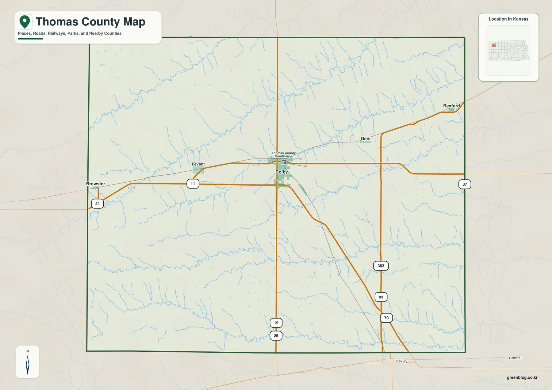
Brewster lies west of Colby along US 24, while Rexford and Gem occupy the northeastern part of the county. Menlo appears close to the eastern edge. South of the main urban corridor, rural roads and stream valleys become more important location references than towns.
Colby stands far above the other communities on the city index
The ranked city panel lists Colby at 5,387, Brewster at 459, Rexford at 146, Gem at 98, and Menlo at 24. These are map index values rather than current official population estimates, but they clearly show how strongly county services and settlement are concentrated in Colby.
Brewster is the second-largest index entry and provides a useful western US 24 reference. Rexford and Gem mark the northeastern rural area, while Menlo is a very small settlement near the eastern side. The spacing between communities reinforces the broad agricultural character of Thomas County.
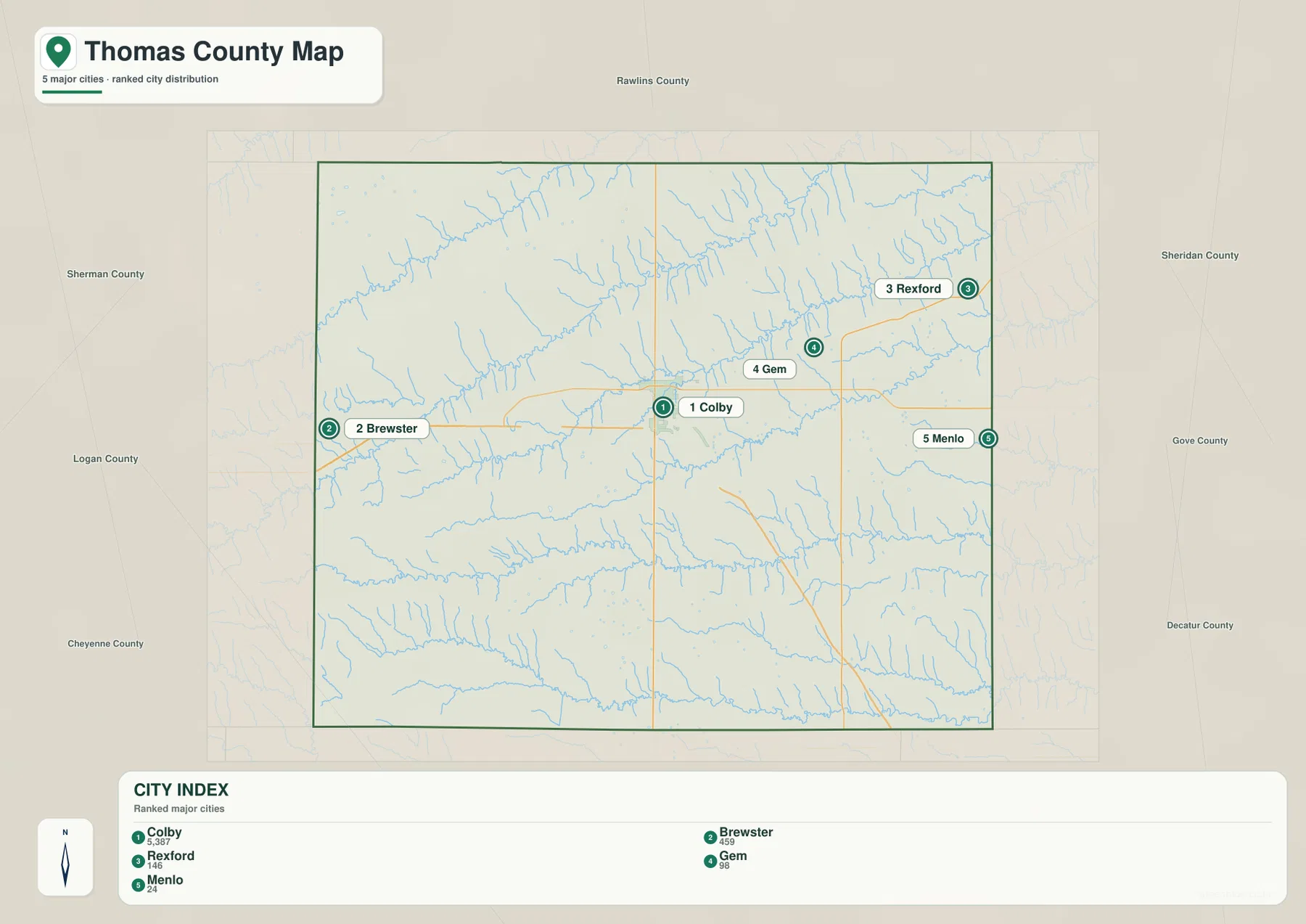
Thomas County’s official profile identifies Colby as the largest town and lists Rexford, Gem, Brewster, and Menlo among the other incorporated communities. Official census counts and the supplied city index are different datasets and should not be treated as interchangeable, but both show the same Colby-centered settlement pattern.
Sappa Creek and Prairie Dog Creek cut long valleys across the northern High Plains
The northern half of the water map is organized around Middle Fork Sappa Creek and South Fork Sappa Creek. South Fork Sappa Creek crosses a large part of the county on a diagonal, collecting many short tributaries that descend from the surrounding uplands. Prairie Dog Creek and North Fork Prairie Dog Creek create another long eastward drainage corridor farther south.
These features show why the county is more dissected than a simple plains landscape might suggest. High surfaces remain broad between the creeks, but each major drainage line develops a deep, narrow valley that becomes more strongly incised toward the east.
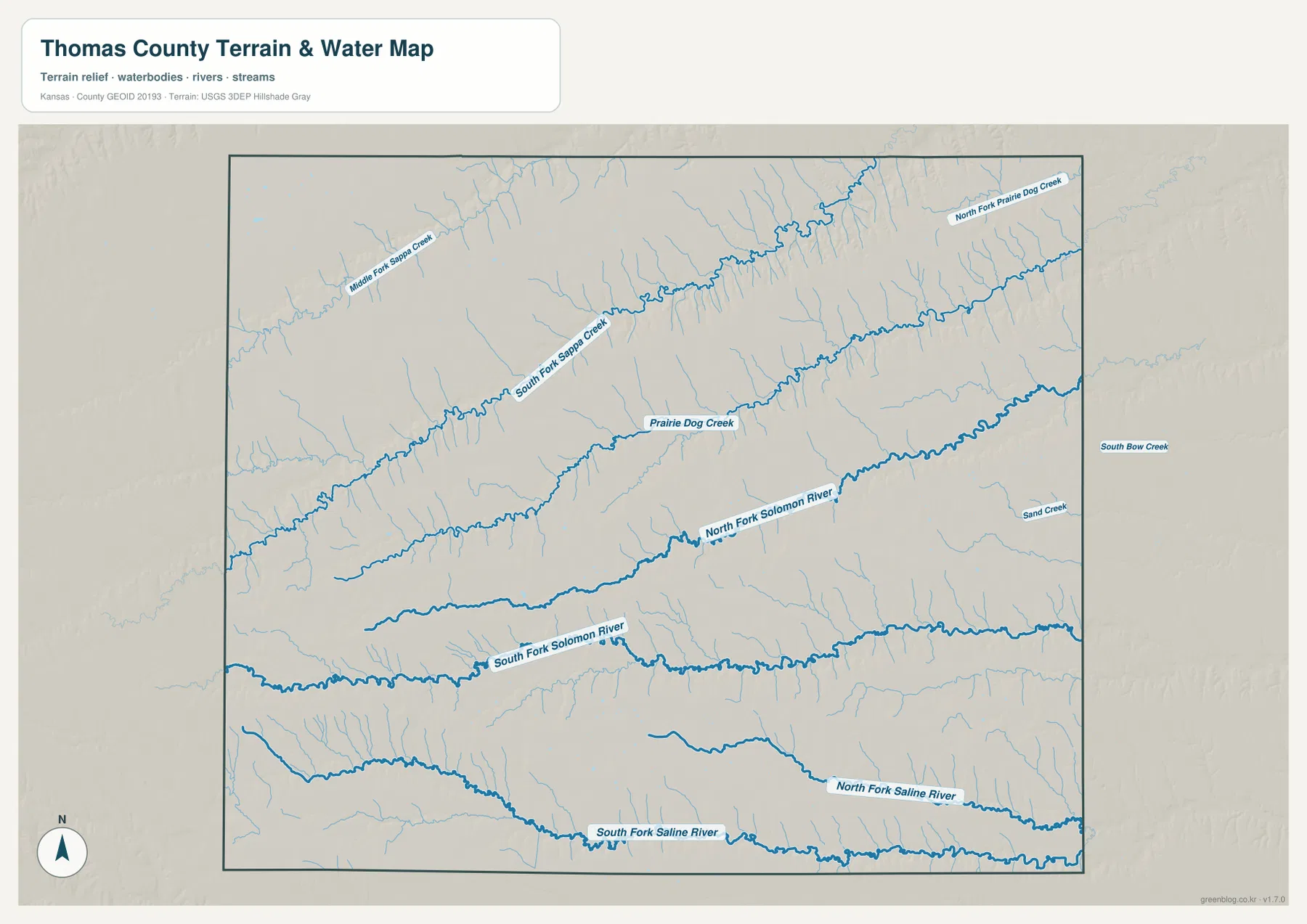
Across the central and southern portions, North Fork Solomon River and South Fork Solomon River form separate eastward valleys. Near the southern edge, North Fork Saline River and South Fork Saline River add two more broad drainage lines. Sand Creek and South Bow Creek appear on the eastern side, adding to the county’s repeated pattern of parallel valleys.
This water image is intended for geographic reference rather than floodplain, navigation, water-quality, parcel, or legal-access decisions. Stream flow and local conditions can change, so current agency information should be used whenever safety or property decisions are involved.
Elevation from 870 to 1,062 meters falls sharply from west to east
The elevation surface ranges from about 870 to 1,062 meters, with a mean near 969 meters. Brown and tan high ground dominates the western side, while greens become increasingly common toward the east. Nearly 200 meters of local relief separates the highest uplands from the lowest creek and river valleys.
The strongest low corridors follow Sappa Creek, Prairie Dog Creek, and the Solomon River forks. In the west, tributaries cut short, steep notches into the high plain. Farther east, the valleys become broader and more connected, producing a clearly terraced appearance across the county.
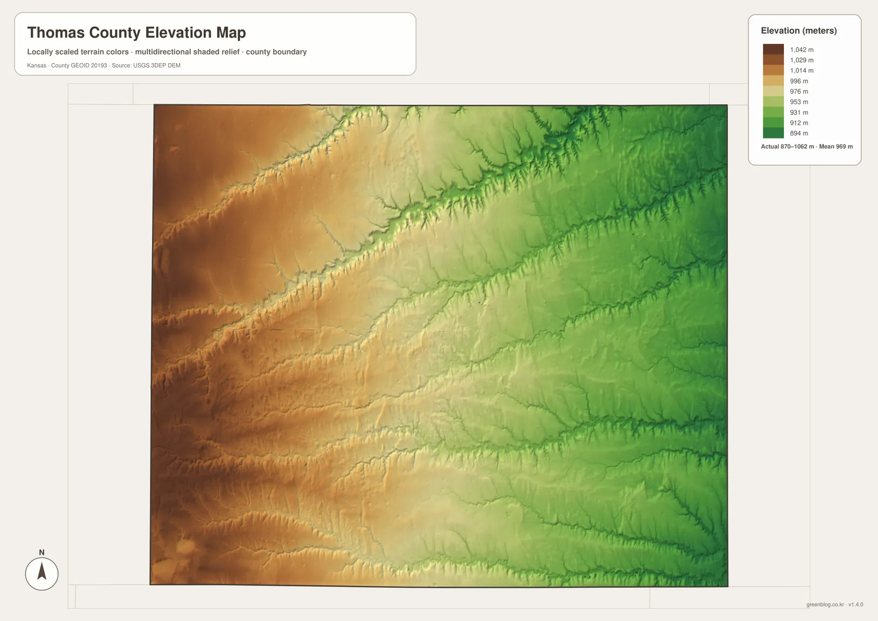
Colby occupies middle-elevation terrain near the county center rather than one of the deepest valleys. Around Rexford and Gem, the Sappa and Prairie Dog drainage networks create more closely spaced cuts. The same pattern repeats in the south where Solomon and Saline tributaries descend toward the eastern side.
The elevation surface is generalized for county-scale comparison. It is not survey-grade or engineering-grade measurement and should not be used for parcel elevations, construction grades, drainage design, or legal boundary work.
The Prairie Museum and Cooper Barn preserve the county’s High Plains story
The Prairie Museum of Art & History in Colby serves as the home of the Thomas County Historical Society and interprets the history of northwestern Kansas. Its outdoor campus includes a sod house, one-room school, 1930s farmstead, church, and the Cooper Barn.
The museum describes the Cooper Barn as the largest barn in Kansas. Together with the homestead and sod-house exhibits, it provides a useful cultural reference for the same treeless High Plains environment visible on the county maps, where agriculture and rail access shaped early settlement.
Dust Bowl history adds context to the open agricultural landscape
The Kansas Historical Society records severe drought and dust storms in Thomas County during the 1930s Dust Bowl years, compounded by low wheat prices. The modern map presents an orderly grid of farms, roads, and towns, but the county’s agricultural history was strongly shaped by climate variability and wind exposure on the High Plains.
Railroads helped Colby and neighboring towns grow during the late nineteenth century, while later drought and economic stress tested those same agricultural communities. That history makes the open western landscape more than a simple expanse of flat farmland.
The Brewster-to-Rexford side of the county reveals the west-to-east terrain drop
Traveling east from Brewster toward Colby on US 24 begins on higher western terrain. Continuing toward Rexford and Gem brings the route closer to the Sappa and Prairie Dog drainage systems, where the relief map shows lower ground and a denser pattern of tributary cuts.
The same west-to-east transition appears south of Colby. High uplands in the west give way to the North and South Fork Solomon valleys and, farther south, the Saline River forks. Because several drainage lines run roughly parallel, the county looks less like one continuous slope and more like a sequence of broad uplands separated by valleys.
For posters, classroom prints, or presentation slides, use the original JPG files in the download archive rather than enlarging the web previews. Small road labels, creek names, community text, and the elevation legend remain clearer at the higher resolution.
Frequently Asked Questions
Which community is largest on the supplied city index?
Colby ranks first at 5,387. Brewster is 459, Rexford 146, Gem 98, and Menlo 24. These are map index values rather than current official population estimates.
Why do so many creek and river valleys run roughly west to east?
The county’s high western plains drain toward lower ground in the east. Sappa Creek, Prairie Dog Creek, the Solomon River forks, and the Saline River forks follow that overall descent, producing several long, nearly parallel valleys across the county.
Can the 870–1,062 meter elevation image be used for surveying?
No. It is a generalized county-scale terrain image for comparing higher western plains with lower creek and river valleys. Parcel elevations, engineering grades, drainage design, and legal boundary work require more precise official data and, where needed, professional surveying.
Map File Information
The archive contains the Thomas County, Kansas general county map, city map, terrain-and-water map, and elevation map as original high-resolution JPG files.
- Included Files: Use only the versions confirmed in the article and supplied images
- File Type: Use the confirmed download contents
- Intended Use: Printing, education, presentations, and map-based projects
Related Maps
Sources and references
- Thomas County, Kansas: About Us — county seat, towns, railroads, and county history
- Kansas Historical Society: Thomas County, Kansas — High Plains setting, Dust Bowl history, Colby, and county development
- Prairie Museum of Art & History — Thomas County Historical Society, Cooper Barn, and High Plains exhibits
- U.S. Census Bureau TIGER/Line Shapefiles — county boundary and geographic reference data
- USGS National Hydrography — river and stream reference data
- USGS 3D Elevation Program — elevation and terrain reference data
Green Map creates custom-edited map images using open geographic data sources such as geoBoundaries, Natural Earth, OpenStreetMap, and government open data. These maps are edited visual materials, not raw data files, and are provided for education, documents, presentations, and graphic reference.