Howard County in southwestern Arkansas has a long north-to-south shape, with Nashville forming the main road hub in the lower southeastern portion and a much higher, more rugged upland occupying the broad northern section. The Cossatot River crosses the northwest, the Saline River winds through the northern interior, and many smaller creeks run through valleys farther south. This page shows Nashville, Dierks, Mineral Springs, Center Point, Saratoga, major roads, waterways, and an actual elevation range of about 79 to 502 meters. You can download the same four maps as high-resolution JPG files in one ZIP.
The county outline itself is useful for orientation. A broad northern block narrows sharply through the middle and then extends south in a long vertical section. Nashville sits toward the eastern side of that lower portion, Dierks is much farther north, Mineral Springs lies southwest of Nashville, and Saratoga is close to the southern end. Center Point appears between Dierks and Nashville. Because the communities are spread over such a long shape, it helps to locate those places first and then follow roads, streams, and elevation from north to south.
Table of Contents
Nashville anchors the southern road network while Dierks marks the transition north
Nashville is the most prominent urban area on the general county map. Route 371 runs west from the city, while Routes 27 and 355 continue south toward the Mineral Springs and Saratoga side. Route 369 provides a long northward connection through the eastern half of the county, and several smaller roads spread west and northwest from Nashville. Use the city as the starting point and then follow the map toward Center Point, Mineral Springs, Saratoga, and Dierks rather than trying to memorize every road number.
The Dierks area has a different road pattern. Routes 70 and 278 pass near the community, Route 4 continues north toward Route 84, and Route 246 crosses the broad northern section. North of Dierks, towns become sparse and road spacing increases while the terrain grows more rugged. The southern Nashville area has a denser network of local roads, while the northern uplands are organized around fewer routes crossing many creek valleys.
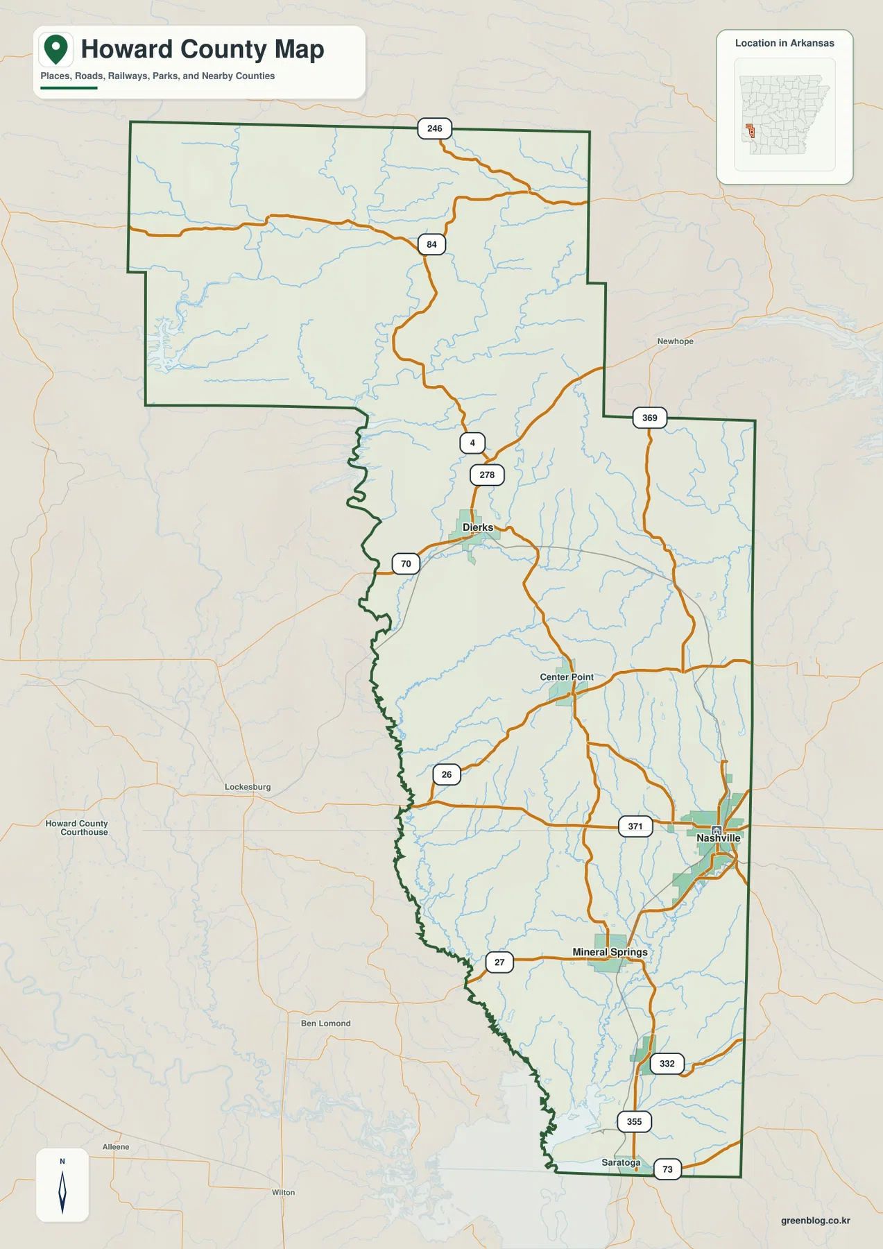
The western boundary is especially irregular through the middle of the county. From southwest of Dierks toward the area west of Nashville, the line repeatedly bends inward and outward near creek valleys and lower ground. The eastern side has longer straight segments, and much of the northern block is simpler in outline. Comparing the boundary with the water map helps explain why the west-central edge looks so different from the straighter eastern side.
Three city connections place Nashville within 6 to 16 miles of nearby communities
The city-connections map uses Nashville as the hub and shows direct point-to-point distances to Mineral Springs, Tollette, and Dierks. Mineral Springs is about 6 miles from Nashville, Tollette about 9 miles, and Dierks about 16 miles. These are straight-line distances rather than driving mileage. They are useful for comparing relative position, but actual road distance and travel time may be longer because routes follow the county’s road network rather than a direct line.
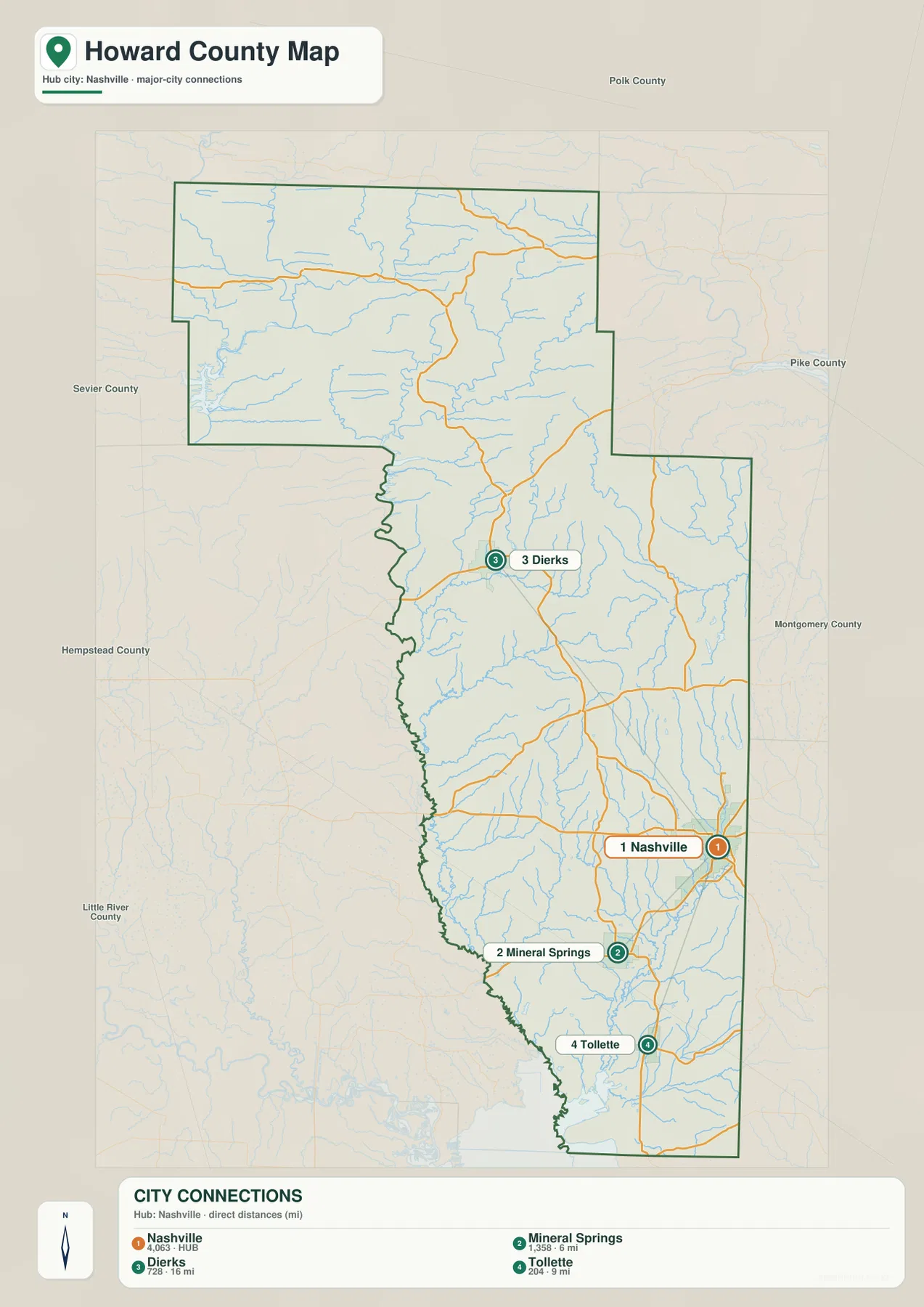
Direction matters as much as mileage. Mineral Springs lies southwest of Nashville, Tollette sits farther south in the narrow lower part of the county, and Dierks is far to the north. The three connections therefore point into very different parts of Howard County rather than along one road corridor. Returning to the general map after this view makes the roads between the communities much easier to follow.
Cossatot and Saline rivers dominate the northern water network
The Cossatot River is the most prominent labeled waterway in the northwestern part of the terrain and water map. It winds through the higher northern landscape close to the western side. East of the river, Harris Creek and White Oak Creek occupy narrower valleys. The Saline River crosses the north-central part of Howard County in a broad, winding channel, and Brushy Creek is labeled on its eastern side. These rivers and creeks create a much more strongly dissected landscape than the lower southern portion of the county.
Moving south from the large northern rivers, the drainage becomes a network of long named creeks. Holly Creek and Muddy Fork appear in the upper-middle section, while Messer Creek follows a long valley toward the irregular western boundary. Farther south, Coleman Creek, Rock Creek, and Blue Bayou cross the central-lower landscape. Dillard Creek, Mine Creek, and Ingram Creek continue through the southern part of the county. The map therefore shifts from large river corridors in the north to many narrower creek valleys farther south.
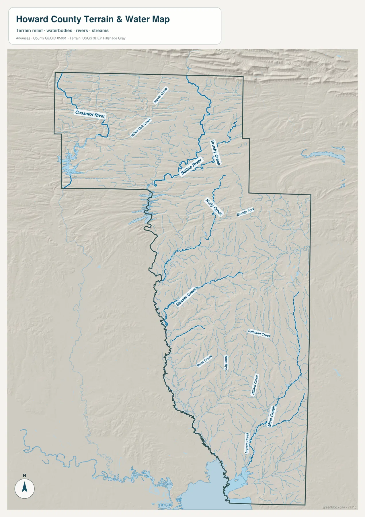
The southern half contains many short tributaries feeding the longer creeks. Around the Nashville and Mineral Springs side, narrow valleys repeat across the lower rolling terrain, and Mine Creek and Ingram Creek continue almost to the southern end of the county. Several watercourses also lie close to the irregular western boundary. This map is intended for geographic reference, not for judging current river stage, flood risk, fishing rules, or live access conditions.
Elevation climbs from about 79 meters in the south to more than 500 meters in the north
The supplied elevation map shows an actual countywide range of about 79 to 502 meters, with a mean near 175 meters. That is roughly 423 meters of relief within Howard County. Brown and tan colors dominate much of the broad northern section, where long ridges and narrow valleys repeat across the landscape. Green terrain becomes increasingly common through the middle and southern parts of the county, especially around Nashville, Mineral Springs, and Saratoga.
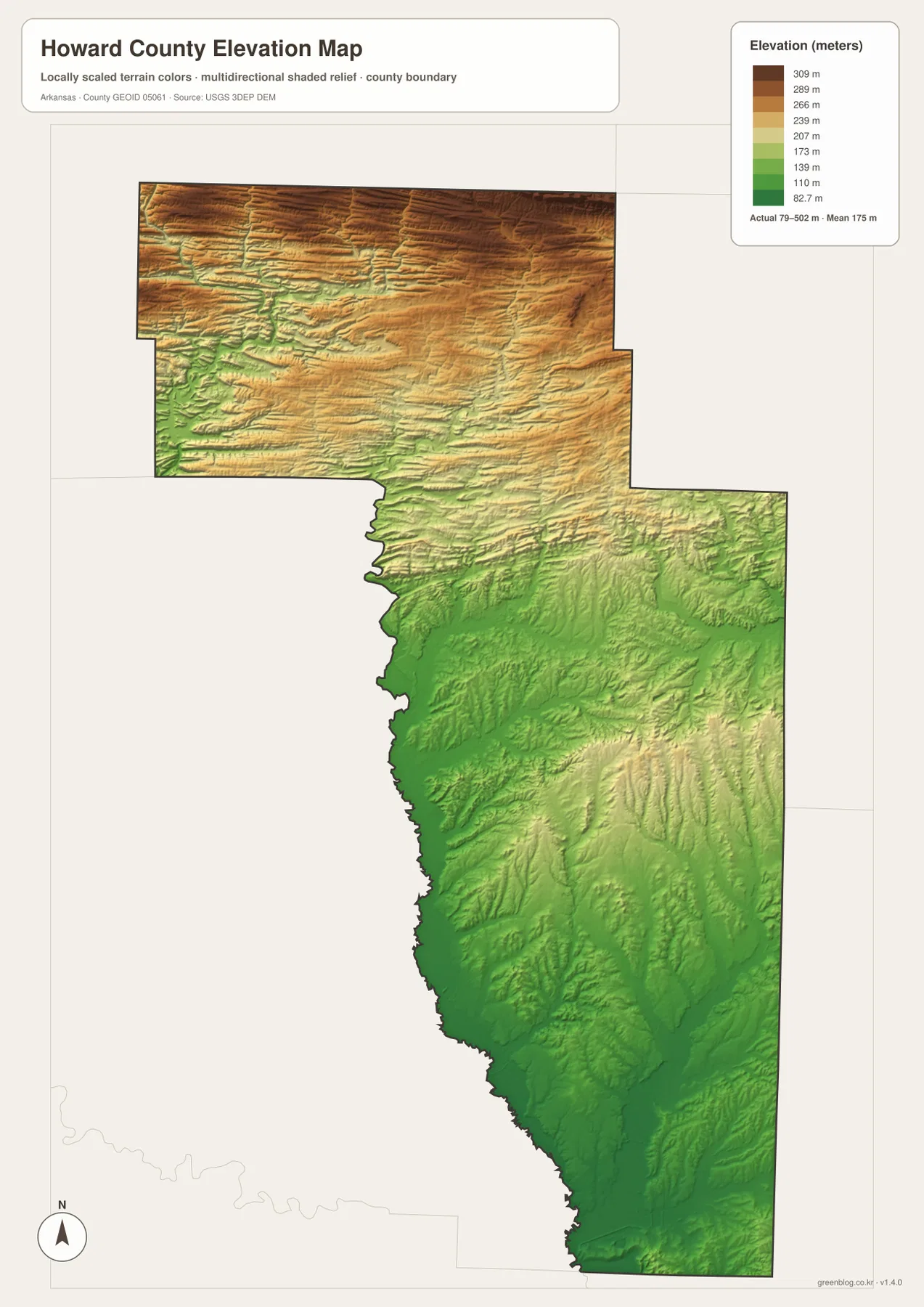
The northern terrain is not one isolated mountain. Instead, many elongated ridges are separated by narrow valleys that carry the Cossatot River, Harris Creek, White Oak Creek, and smaller tributaries. Around the Saline River, the valley floor appears lower than the ridges around it even though the surrounding northern landscape remains high overall. Switching between the water and elevation views shows why the large northern rivers bend repeatedly rather than following straight channels.
South of Dierks, brown highland colors gradually give way to more green. The Nashville, Mineral Springs, and Saratoga side is lower than the broad northern block, but it is not completely flat. Short ridges and narrow creek valleys still cross the southern half. The elevation image is intended for county-scale comparison, not survey-grade measurement, so precise parcel, road, or building heights require original USGS elevation data or a professional survey.
Following the county south from Dierks to Nashville reveals the clearest change
A practical way to compare the four map views is to begin around Dierks and move south toward Nashville. North of Dierks, the map is dominated by high ridges and the Cossatot and Saline river systems, while roads are relatively sparse. Passing Dierks and continuing through Center Point toward Nashville, elevation decreases, local roads become more frequent, and the water network changes from large river valleys to many long creeks. Reading the maps along one north-to-south path connects the road, water, and elevation information naturally.
Continuing south toward Mineral Springs, Tollette, and Saratoga makes the contrast stronger. The city-connections map shows Mineral Springs only about 6 miles from Nashville and Tollette about 9 miles away, while Dierks is about 16 miles to the north. The elevation map also becomes progressively greener in the lower county. Those two views together explain why Howard County links a high northern upland with a lower southern settlement and creek landscape.
High-resolution JPG files for roads, rivers, and elevation detail
The WebP images in the article are optimized for quick page viewing. The download ZIP contains the same four maps as high-resolution JPG files, each measuring 2572 × 3638 pixels in portrait orientation. Use the general map for communities and roads, the city-connections map for straight-line direction and distance from Nashville, the terrain and water map for the Cossatot and Saline rivers and named creeks, and the elevation map for comparing the high northern uplands with the lower southern half.
The JPG files are suitable for classroom reference, presentations, trip preparation, personal printing, and general orientation. They should not replace legal boundary records, parcel surveys, flood studies, engineering plans, or live navigation. When exact or current information is required, consult Census TIGER/Line boundaries, USGS hydrography, USGS elevation data, and the appropriate local or state source for the specific decision.
Frequently Asked Questions
How far are Mineral Springs, Tollette, and Dierks from Nashville on the city map?
The city-connections map shows straight-line distances of about 6 miles from Nashville to Mineral Springs, 9 miles to Tollette, and 16 miles to Dierks. These are not driving distances, so actual road mileage and travel time should be checked with a current road or navigation map.
Where is the highest terrain in Howard County?
The highest terrain on the supplied elevation map is concentrated in the broad northern section of the county. The actual displayed range is about 79–502 meters with a mean near 175 meters. Brown and tan ridges dominate north of Dierks, while lower green terrain becomes much more common around Nashville, Mineral Springs, and the southern end.
Where are the Cossatot and Saline rivers on the map?
The Cossatot River is labeled in the northwestern part of Howard County, while the Saline River winds through the north-central area. Harris Creek, White Oak Creek, and Brushy Creek are also labeled nearby. Comparing the water and elevation views shows these rivers occupying valleys within the county’s higher northern terrain.
Map File Information
The ZIP contains the general county map, city-connections map, terrain and water map, and elevation map as high-resolution JPG files for printing or offline reference.
- File Type: ZIP containing 4 JPG files
Related Maps
Sources and references
- U.S. Census Bureau TIGER/Line Shapefiles – county boundary and road data
- USGS National Hydrography – rivers, streams, and hydrography data
- USGS 3D Elevation Program – elevation and terrain data
Green Map creates custom-edited map images using open geographic data sources such as geoBoundaries, Natural Earth, OpenStreetMap, and government open data.
These maps are edited visual materials, not raw data files, and are provided for education, documents, presentations, and graphic reference.