Miami County sits on the southern edge of the Kansas City metropolitan area, with Paola serving as the strongest central reference on the supplied maps. Louisburg lies to the east, Osawatomie to the southwest, Fontana farther south, and Spring Hill reaches the northern edge. US 169, K-7, US 69, and K-68 give the county several major road corridors, but the physical landscape is just as important because lakes, creeks, and the Marais des Cygnes River cut broad valleys through rolling uplands. High-resolution map files are available for download in the section below.
This page combines town and road orientation with waterways and elevation. The WebP images are convenient online previews, while the original high-resolution JPG versions of all four supplied maps can be downloaded together in one ZIP for printing, classroom use, or offline reference. Hillsdale Lake, the Wea Creek system, Lake Miola, and the Marais des Cygnes River help explain why the county’s terrain varies so much from north to south and from the river valleys to the higher eastern hills.
Table of Contents
Paola is the easiest road reference between US 169, K-7, and the eastern US 69 corridor
Paola stands out near the middle of the general county map and is the easiest place from which to understand the road network. US 169 and K-7 run north–south just east of the city and continue toward Spring Hill, while local roads spread toward Osawatomie and the western side of the county. Louisburg occupies a different corridor in the east, where US 69 and K-68 provide the strongest route references.
Osawatomie is southwest of Paola, and Fontana lies farther south near the middle of the county. Bucyrus and Somerset appear as smaller northern and east-central places, while the southern half becomes increasingly rural. The main towns therefore do not form a single straight chain; they are distributed around Paola in several directions and connected by different highways and county roads.
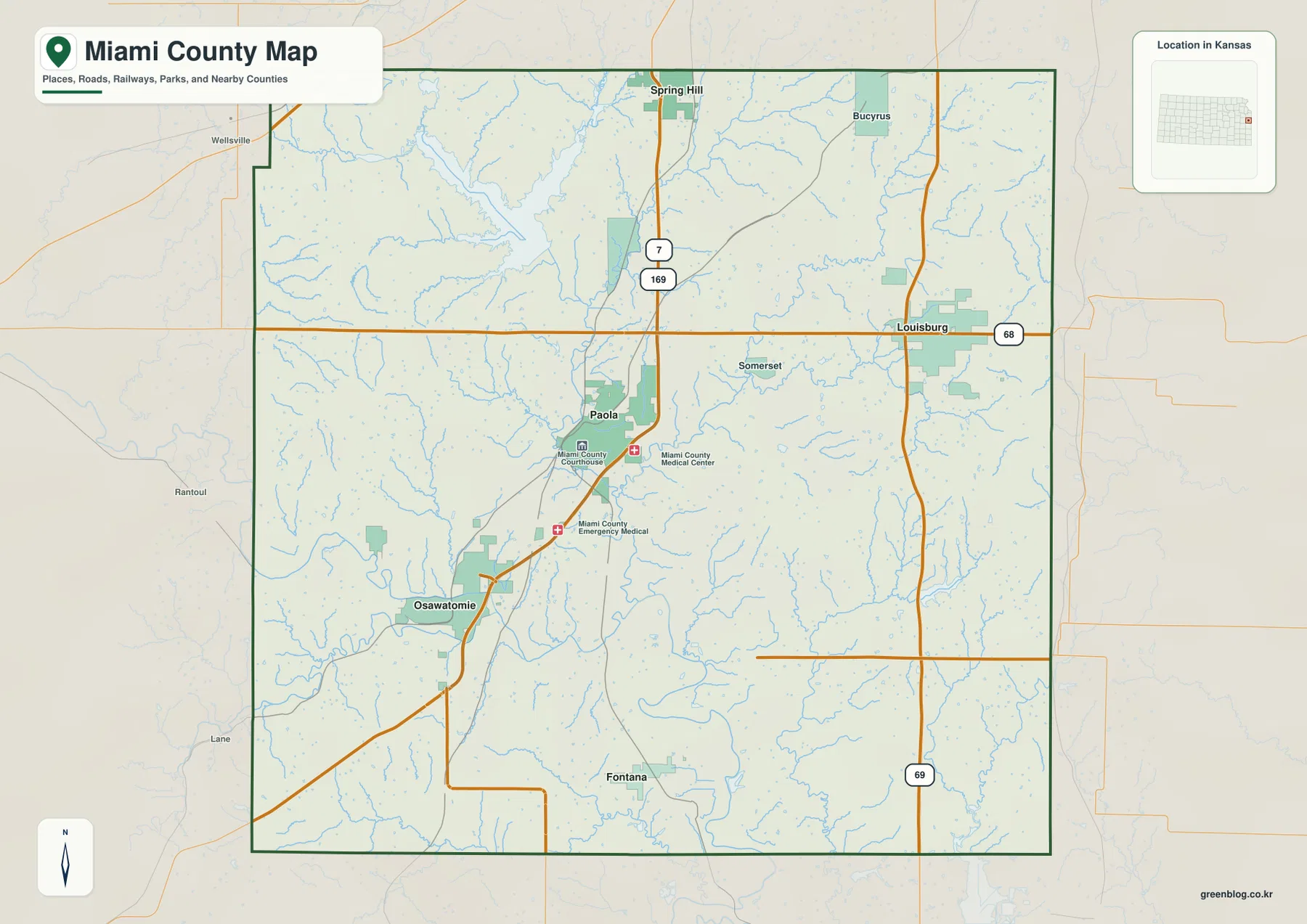
Hillsdale Lake is another major orientation feature in the north. It lies between the Spring Hill and Paola areas and occupies a much larger footprint than the smaller city lakes. Kansas Department of Wildlife and Parks describes Hillsdale State Park as a reservoir recreation area between Spring Hill and Paola, making the lake a useful landmark for understanding the northern half of Miami County.
Direct distances from Paola clarify the spacing of Louisburg, Osawatomie, and Fontana
The city-connections map reduces the county to four major communities. Its printed city index lists Paola at 5,770, Louisburg at 5,094, Osawatomie at 4,182, and Fontana at 409. These are the index figures used on the supplied map rather than a replacement for the latest official population estimates, but they explain the relative visual emphasis of the four city markers.
Paola is marked as the hub, with Louisburg about 10 direct miles to the east, Osawatomie about 8 direct miles to the southwest, and Fontana about 11 direct miles to the south. Those are straight-line distances, not driving distances, so actual road travel will be longer and depends on the route used. The map is most useful for comparing direction and spacing before moving to the more detailed road view.
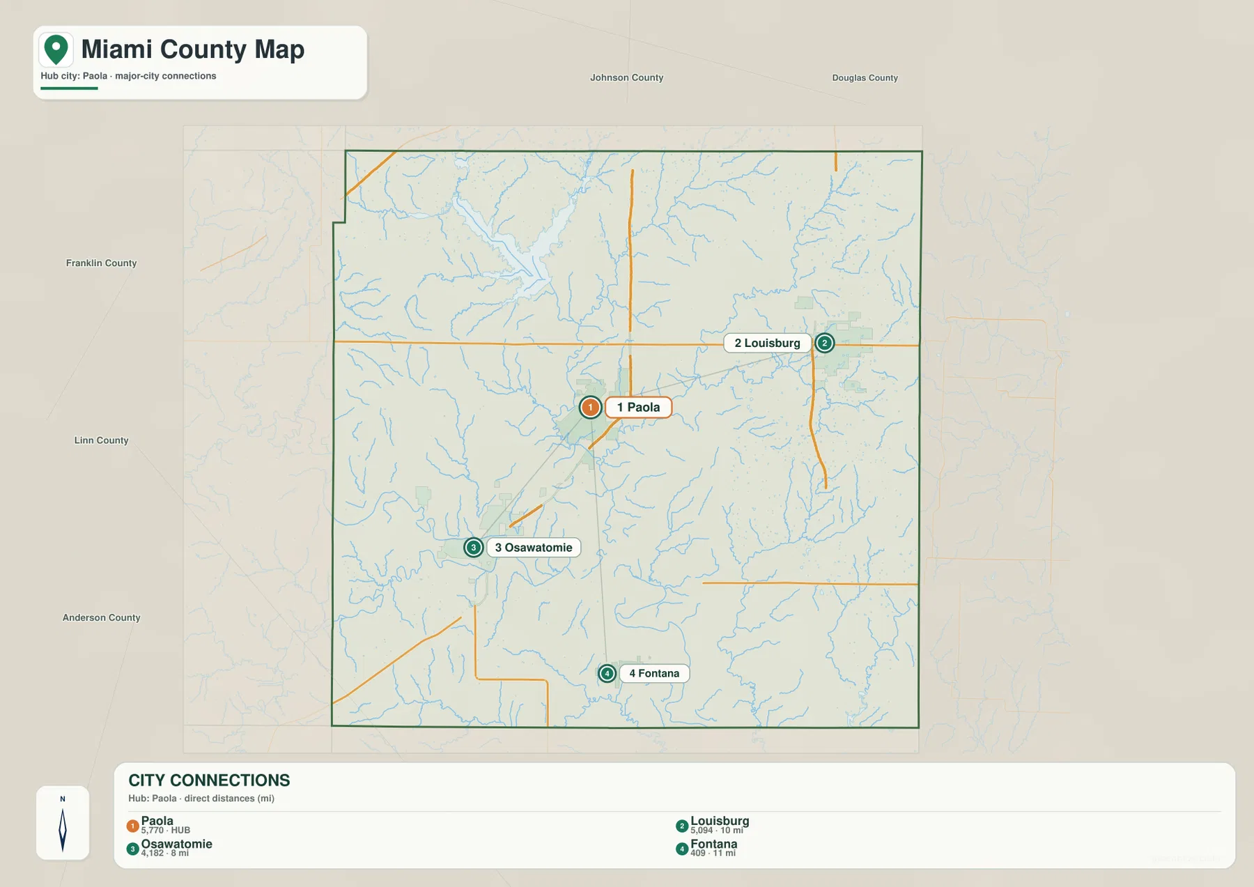
The distance pattern also matches the major road layout. Louisburg is reached through the eastern US 69 and K-68 side of the county, while Osawatomie belongs to the southwestern road and rail corridor below Paola. Fontana sits farther south in a quieter rural area where creeks and local roads become more visually important than large city blocks.
The Marais des Cygnes River defines the broad southern lowland
The Marais des Cygnes River is the most prominent named waterway on the terrain-and-water map. It passes the Osawatomie area, runs east across the southern half of the county, and then bends southeast. The river occupies a broad low corridor that becomes even more obvious on the elevation map, where the surrounding valley is one of the largest continuous green areas.
Several smaller drainage systems feed the county from higher ground. Bull Creek runs south from the Paola area, while North Wea Creek and South Wea Creek cut through the eastern half near Louisburg. Middle Creek occupies the southeast, and Elm Branch is labeled farther north. Their branching shapes show how water moves from the rolling uplands into larger river valleys.
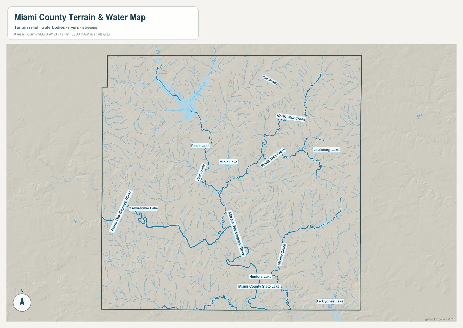
The county contains a notable collection of lakes. Lake Miola and Paola Lake are near Paola, Louisburg Lake is near the eastern city, and Osawatomie Lake lies just north of the Marais des Cygnes corridor. Farther south, Miami County State Lake and Hunters Lake are close together, and part of La Cygne Lake appears near the southeastern edge. Miami County’s official visitor information highlights lakes and outdoor recreation as a major part of the area’s landscape.
This layer is intended for geographic water reference, not floodplain, navigation, water-quality, parcel, or legal-access decisions. Stream depth and flow can change, and a mapped lake does not by itself indicate current boating or recreation rules. Use current agency information when safety, access, or facility status matters.
Elevation from about 242 to 352 meters separates river valleys from higher eastern hills
The elevation map spans roughly 242 to 352 meters, with a mean near 296 meters. The broadest low terrain follows the Marais des Cygnes River across the south and the connected drainage corridors through the center of the county. Higher brown and dark tan hills are especially prominent in the east and northeast, with additional ridges along parts of the western edge.
A large low corridor also extends south from the Hillsdale Lake area toward the center of the county. Around Paola, several creek valleys merge and divide the uplands into narrow ridges. East of Louisburg, the hills become more tightly dissected, while Middle Creek and other southeastern tributaries create lower strips between them.
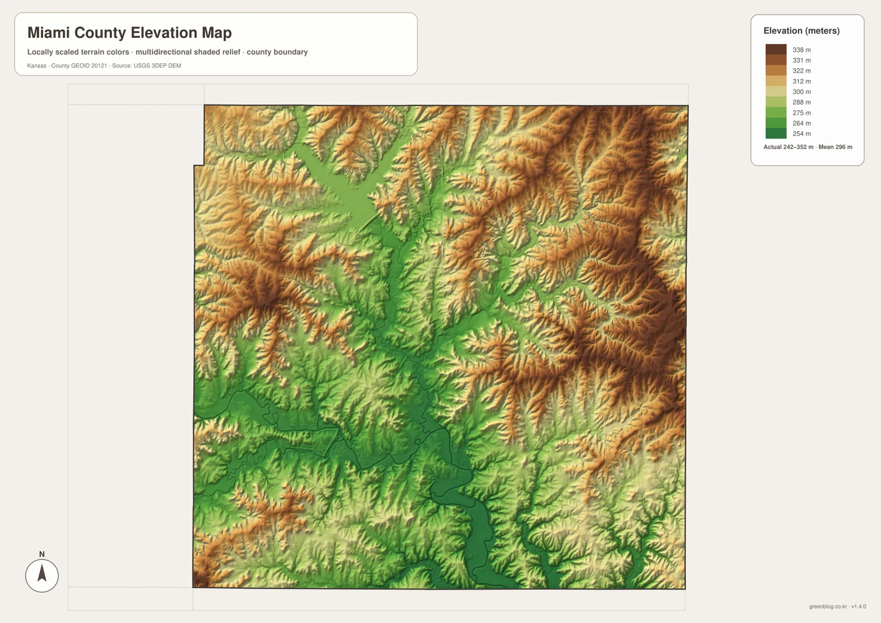
The connection between water and relief is easy to see when the two physical maps are compared. Green lowlands follow the Marais des Cygnes River, North and South Wea Creek, Bull Creek, and many smaller tributaries, while brown ridges occupy the ground between them. The result is a rolling landscape with deeply branching valleys rather than a uniformly flat surface.
This elevation surface is generalized for county-scale comparison. It should not be used to establish parcel elevations, construction grades, drainage design, or legal boundaries. Detailed site work requires more precise official elevation data and, when appropriate, professional field surveying.
Hillsdale Lake links the northern road network with a major reservoir valley
Hillsdale Lake is one of the strongest physical landmarks in northern Miami County. Kansas Department of Wildlife and Parks places Hillsdale State Park between Spring Hill and Paola and describes a large reservoir surrounded by park and wildlife land. The U.S. Army Corps of Engineers also notes that releases from Hillsdale Lake enter Big Bull Creek before reaching the Marais des Cygnes River.
That connection helps tie the map layers together. The general map shows the lake between northern communities and major roads, while the elevation surface shows a broad low valley extending south from the reservoir area. Looking at the lake together with Paola and Spring Hill gives a much clearer picture of northern Miami County than roads alone.
Osawatomie and the southern lakes sit close to the county’s main river corridor
Osawatomie occupies a distinctly different setting from Louisburg or Spring Hill because it lies close to the Marais des Cygnes River lowland. Osawatomie Lake appears just north of the main river corridor, and the surrounding terrain is broad and low compared with many of the eastern uplands. This relationship is especially clear on the elevation map, where the river valley forms a continuous green belt.
Farther south near Fontana, Miami County State Fishing Lake sits close to the Marais des Cygnes system. Kansas Department of Wildlife and Parks describes it as a 101-acre lake bordered by wooded hillsides and the river. On the supplied water map, it appears close to Hunters Lake within the southern lowlands, providing another useful reference for the rural part of the county.
Choose the road, city, water, or elevation layer for the task
Use the general county map when roads, towns, hospitals, county boundaries, and major lakes need to appear in one view. The city-connections map is better for quickly comparing Paola, Louisburg, Osawatomie, and Fontana and the straight-line distances from the Paola hub. It intentionally removes much of the detail that would distract from town spacing.
The terrain-and-water map is the best choice for the Marais des Cygnes River, Bull Creek, the Wea Creek system, Middle Creek, and the county’s many lakes. Switch to the elevation layer when the question involves the low river corridor or the higher eastern hills. Moving between those two physical maps makes the relationship between streams and valleys much easier to see.
For large prints or presentation slides, use the original JPG files in the ZIP rather than enlarging the web previews. The high-resolution versions preserve small road labels, creek names, town text, and the elevation legend more clearly. If only part of a map is cropped for a handout, keep enough surrounding context—such as a north arrow, highway number, or legend—to make the selected area understandable.
Frequently Asked Questions
Which direction are Louisburg and Osawatomie from Paola?
Louisburg is east of Paola and is shown about 10 direct miles away on the city-connections map. Osawatomie is southwest of Paola at about 8 direct miles. Those are straight-line measurements, so road travel is longer and depends on the route.
Where does the Marais des Cygnes River cross Miami County?
The river follows the southern lowlands near Osawatomie, runs eastward across the county, and then bends toward the southeast. Miami County State Fishing Lake and several tributaries lie close to this low river corridor, making the water and elevation maps especially useful together.
Can the 242–352 meter elevation map be used for surveying?
No. It is a generalized county-scale terrain surface for comparing valleys and uplands. Parcel elevations, engineering grades, drainage design, and legal boundary work require more precise official data and, where needed, professional field surveying.
Map File Information
The archive contains the Miami County, Kansas general county map, city-connections map, terrain-and-water map, and elevation map as original high-resolution JPG files.
- Included Files: Use only the versions confirmed in the article and supplied images
- File Type: Use the confirmed download contents
- Intended Use: Printing, education, presentations, and map-based projects
Related Maps
Sources and references
- Miami County, Kansas official visitor information — county communities, lakes, and outdoor recreation
- Kansas Department of Wildlife and Parks: Hillsdale State Park — Hillsdale Lake location and recreation context
- Kansas Department of Wildlife and Parks: Miami State Fishing Lake — lake and Marais des Cygnes River setting
- U.S. Census Bureau TIGER/Line Shapefiles — county boundary and geographic reference data
- USGS National Hydrography — river and stream reference data
- USGS 3D Elevation Program — elevation and terrain reference data
Green Map creates custom-edited map images using open geographic data sources such as geoBoundaries, Natural Earth, OpenStreetMap, and government open data.
These maps are edited visual materials, not raw data files, and are provided for education, documents, presentations, and graphic reference.