Pulaski County in central Georgia is organized around Hawkinsville, a county seat where several numbered roads meet before spreading toward the county edges. You can download all four maps on this page as high-resolution A3 JPG files in one ZIP archive: a county reference map, a city map, a terrain-and-water map, and an elevation map. Together they show much more than the outline alone, including Hawkinsville’s position, the directions of major roads, the Ocmulgee River and its tributaries, and a relatively low relief range of about 55 to 119 meters.
The map set is especially useful because Pulaski County does not have a long list of major cities competing for attention. Hawkinsville is the single ranked major city on the supplied city map, so the county is easier to understand by looking at the roads, neighboring counties, stream valleys, and gradual changes in elevation around that one center. WEBP images are used for the page previews, while the ZIP contains the larger JPG files intended for printing, classroom work, reports, and other reference uses.
Pulaski County was established in 1808, and the existing source material also connects Hawkinsville with the Ocmulgee River and local history. This article keeps the emphasis on what the provided maps actually show. Instead of repeating a general county description, it follows the visible road network from Hawkinsville, compares the surrounding county directions, traces named creeks toward the Ocmulgee, and then uses the elevation map to explain why the stream corridors appear lower than the ridges around them.
Table of Contents
Roads radiating from Hawkinsville inside the Pulaski County boundary
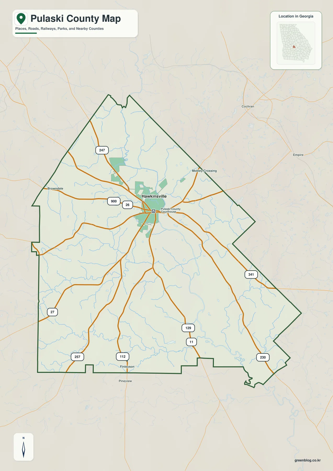
Hawkinsville sits in the northern half of the county, close to the center of the road network rather than at an outer corner. The Pulaski County Courthouse label appears beside the city, and several roads pass through or near the same area before continuing in different directions. The county outline is irregular: there is a narrow projection at the north, stepped sections along the west, and long diagonal boundaries toward the southeast. Looking at Hawkinsville together with that outline gives a much clearer sense of the city’s position than a simple dot on a statewide map.
The road labels visible on the map include 247 northwest of Hawkinsville, 26 and 900 near the central area, 341 running toward the southeast, and 129 with 11 heading south. Other labels include 112 and 257 to the southwest, 27 farther west-southwest, and 230 in the southeastern part of the county. These are useful orientation routes rather than a complete street network. Small local roads, private drives, and current turn-by-turn routing are outside the purpose of the map, so a navigation service is still the right tool for an actual trip.
Smaller place labels provide additional reference points. Browndale appears to the west, Mobley’s Crossing is northeast of Hawkinsville, and Finleyson is near the southern side of the county. Outside the boundary, Cochran, Empire, and Pineview help show what lies beyond Pulaski County. These labels are valuable when the goal is to explain direction and regional position rather than to create an exhaustive settlement list.
One major city, with six neighboring county directions around it
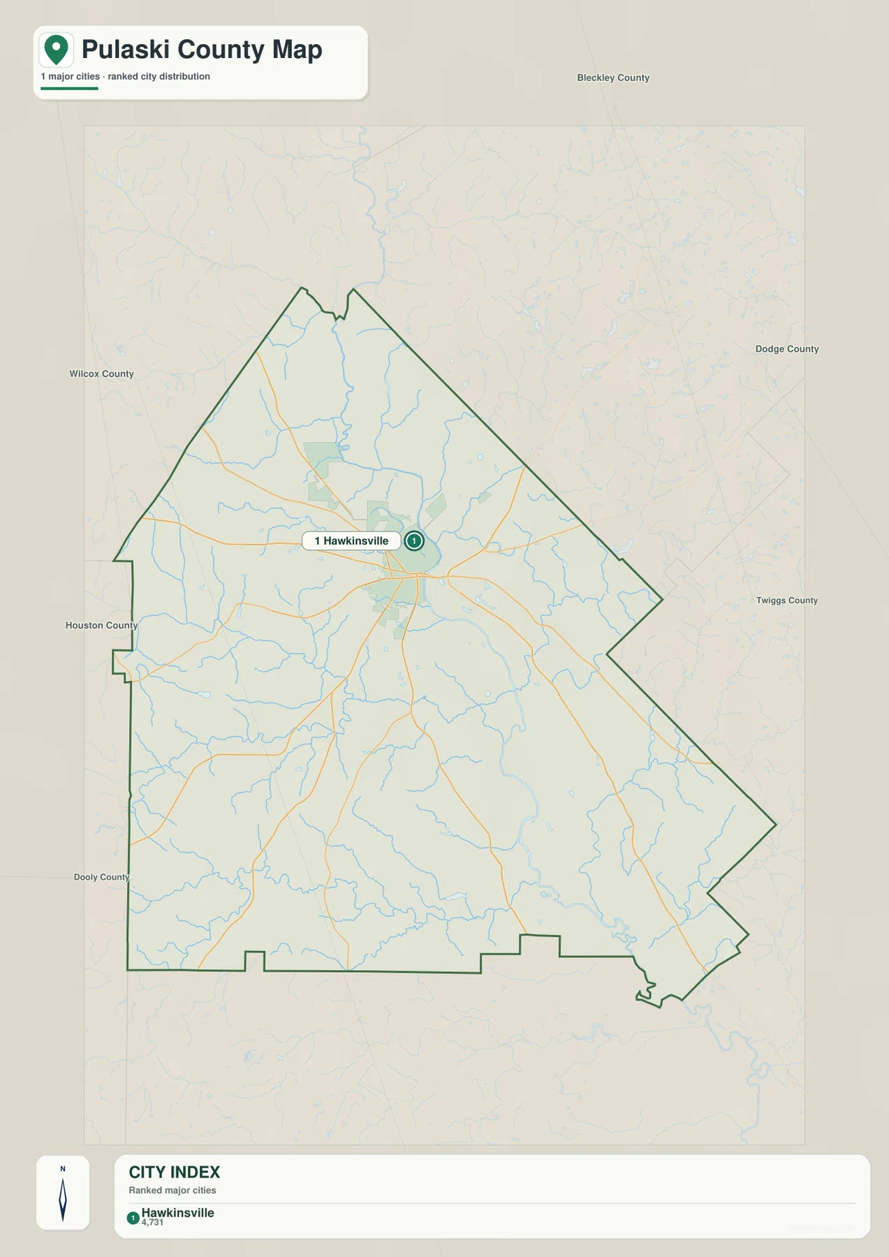
The city map is unusually simple because it ranks only Hawkinsville as a major city. There are no distance connectors to several peer cities, as there are on many county city maps. That makes Hawkinsville the natural reference point for the whole page. The map is therefore more useful for answering “where is the county’s main city relative to its boundaries and neighbors?” than for comparing a network of incorporated places.
The neighboring county labels add the missing regional context. Bleckley County is shown to the north, Dodge County to the east, and Twiggs County to the southeast. Dooly County lies to the southwest, Houston County to the west, and Wilcox County appears to the northwest. Pulaski County is consequently surrounded by several central Georgia counties rather than lying against a state line or coastline. Hawkinsville is positioned so that roads can extend toward several of those county directions from one central hub.
This layout also explains why a city-count description alone would be too thin for Pulaski County. The important geographic story is not a chain of multiple cities but a single county seat connected to a broad rural area, neighboring counties, and a dense drainage network. When the county map and city map are compared side by side, Hawkinsville’s role becomes much clearer without needing to add communities that the supplied city ranking does not include.
From Big Creek and Town Creek to the Ocmulgee River lowlands
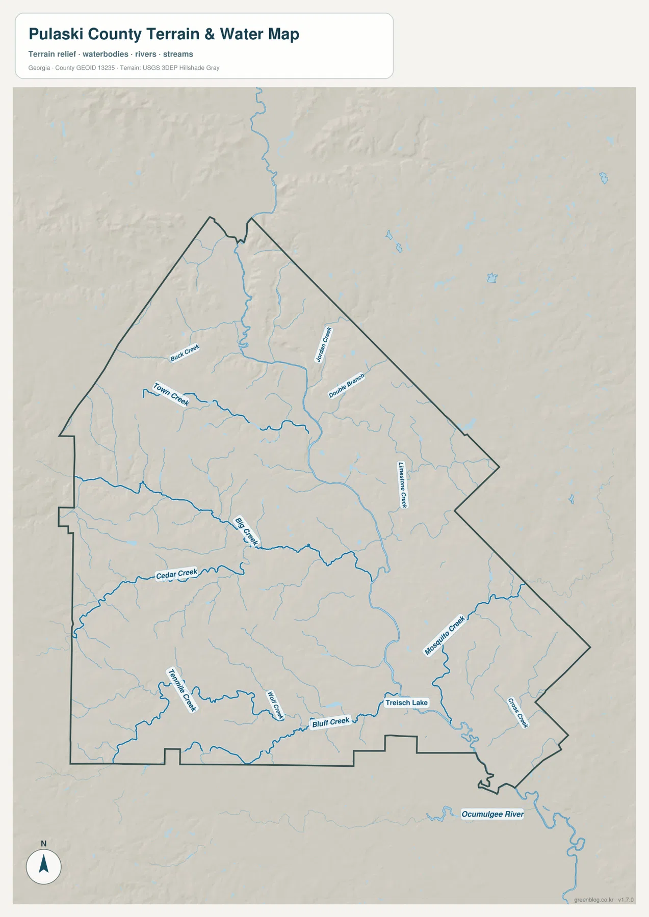
The largest named water feature is the Ocmulgee River, shown along the southeastern side below the county boundary. Inside the county, Big Creek forms a conspicuous central drainage line. Town Creek and Buck Creek are labeled in the northwestern part, while Jordan Creek and Double Branch appear farther northeast. Cedar Creek crosses the western interior, and Limestone Creek is labeled in the eastern half. The result is a branching network rather than a county dominated by one isolated stream.
Several more names appear in the southern half. Trennille Creek, Wolf Creek, and Bluff Creek occupy the southwest and south-central areas, while Mosquito Creek and Coal Creek are labeled toward the southeast. Treisch Lake appears near Mosquito Creek. These features help explain why the open spaces between the road corridors are not simply flat, undivided land. Small valleys and tributaries repeatedly cut across the county before water eventually reaches larger drainage routes.
The water map should not be used as a flood-hazard, boating, fishing-regulation, or parcel-boundary map. Its strength is geographic orientation: it shows where named streams lie relative to the county outline and how they fit into the terrain. For flood risk or legal water-boundary questions, current agency data is necessary. For understanding the county’s drainage pattern, however, the map is much clearer than trying to infer every creek from the road map alone.
A 55–119 m elevation range shaped by creek valleys and gentle ridges
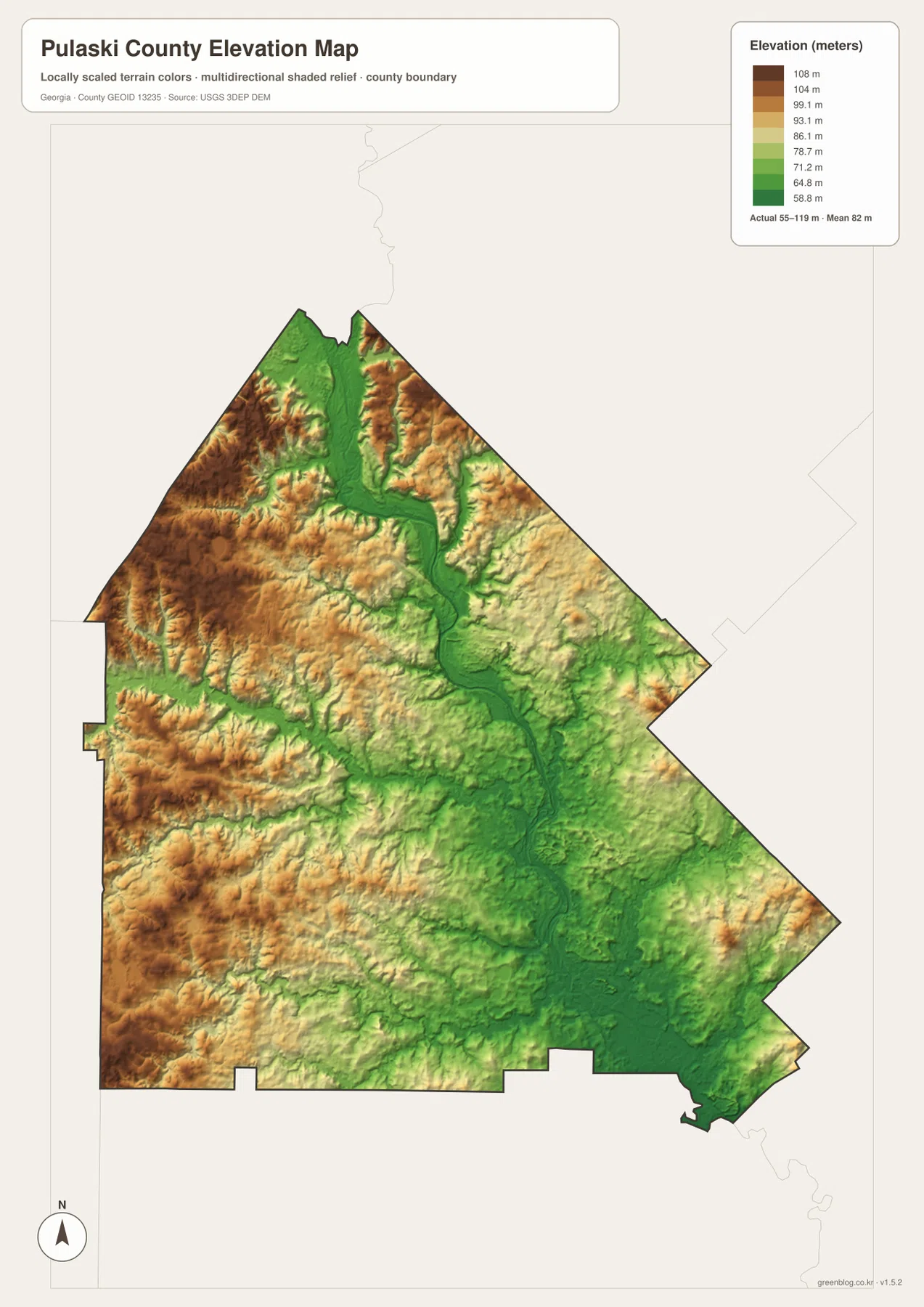
The elevation legend gives an actual county range of roughly 55 to 119 meters, with a mean near 82 meters. Those numbers are important because they show that Pulaski County is not a mountain county. The visible relief comes from modest differences between ridges and stream valleys. Brown and tan areas mark relatively higher ground, while green areas identify lower terrain, making the drainage network visible even before the creek labels are added.
Higher colors are more common along parts of the west and northwest, with additional raised ridges in the northeastern side. Lower green corridors branch through the center and continue toward the southeast, where the Ocmulgee River side of the county is especially low. Comparing this map with the terrain-and-water map shows a consistent relationship: Big Creek and other tributaries occupy lower valleys, while slightly higher ground remains between them.
This elevation image is intended for county-scale comparison, not engineering or survey work. The shaded relief and color ramp make broad differences easier to see, but they do not replace a site-specific elevation survey. For a classroom map, county profile, or general geographic reference, the 55–119 m range is enough to explain why the landscape appears gently rolling rather than completely flat and why the waterways follow the green valley corridors.
What changes when the roads, water, and relief are read together
Each map answers a different part of the same geographic question. The county map shows Hawkinsville and the principal road directions. The city map strips that information down to one major-city reference and the surrounding county names. The terrain-and-water map fills the rural spaces with Big Creek, Town Creek, Cedar Creek, Mosquito Creek, and other tributaries. The elevation map then explains why those waterways occupy narrow green corridors and why the land between them rises gradually.
South of Hawkinsville, the road labels 129 and 11 continue through a landscape crossed by multiple tributaries. The 112 and 257 directions to the southwest pass through areas where stream valleys divide slightly higher ground. To the southeast, the 341 and 230 corridors lead toward lower terrain closer to the Ocmulgee River side. Northwest of Hawkinsville, the 247 direction reaches terrain that is more often shown in higher tan and brown shades.
That combination is more useful than a generic statement that Pulaski County is “rural central Georgia.” It gives specific landmarks for explaining the county: Hawkinsville as the administrative and road center, the Ocmulgee River as the major river reference, a network of named creeks across the interior, and a modest but visible elevation contrast between valleys and ridges. Those details are all present in the supplied maps and can be used without inventing features that are not shown.
Choosing the right Pulaski County map for a report, class, or printout
Start with the county map when the main need is Hawkinsville, the county boundary, or the directions of the numbered roads. Use the city map when you want the cleanest possible view of Hawkinsville relative to Bleckley, Dodge, Twiggs, Dooly, Houston, and Wilcox counties. The terrain-and-water map is the better choice for named creeks and the Ocmulgee River, while the elevation map is best for comparing the 55–119 m range and the lower drainage corridors with the higher ground around them.
- Boundary and roads: Use the county map for Hawkinsville and road labels such as 247, 26, 341, 129/11, 112, 257, and 230.
- City and neighboring counties: Use the city map when Hawkinsville and the surrounding county directions are the main focus.
- Rivers and creeks: Use the terrain-and-water map for the Ocmulgee River, Big Creek, Town Creek, Cedar Creek, Mosquito Creek, and other named waterways.
- Terrain height: Use the elevation map for the roughly 55–119 m range, the 82 m mean, and the contrast between green valleys and higher ridges.
The downloadable ZIP is useful when the smaller webpage previews are not enough. It contains the same four map themes as high-resolution A3 JPG files, so you can keep the county reference, city, water, and elevation maps together for printing or document work. The ZIP avoids the need to save each preview separately and provides a consistent file set for presentations, lessons, local-history notes, and personal reference projects.
Frequently Asked Questions
Why does the city map rank only Hawkinsville?
The supplied city map identifies one ranked major city in Pulaski County, and that city is Hawkinsville. The purpose is therefore to use Hawkinsville as the county’s main location reference rather than to invent a multi-city comparison that the map does not contain.
Why are the Ocmulgee River side and the creek corridors greener on the elevation map?
Green represents relatively lower terrain within Pulaski County. The map’s actual range is about 55–119 m with a mean near 82 m, and stream valleys occupy the lower parts of that range. The southeastern Ocmulgee River side and branching interior drainage corridors are therefore shown lower than many western and northern ridges.
What is included in the downloadable ZIP?
The ZIP contains four high-resolution A3 JPG files: the county reference map, the Hawkinsville-centered city map, the terrain-and-water map, and the elevation map. The WEBP images in the article are lighter previews, while the JPG files are more suitable for printing and document work.
Map File Information
Download four high-resolution A3 JPG maps of Pulaski County in one ZIP archive: county, city, terrain-and-water, and elevation.
- Included Files: County map, city map, terrain-and-water map, elevation map
- File Type: 4 JPG files / ZIP archive
Related Maps
Sources and data references
- U.S. Census Bureau QuickFacts for Pulaski County
- New Georgia Encyclopedia entry for Pulaski County
- U.S. Census Bureau TIGER/Line boundary and road data
- USGS National Hydrography water data
- USGS 3D Elevation Program
Green Map creates custom-edited map images using open geographic data sources such as geoBoundaries, Natural Earth, OpenStreetMap, and government open data. These maps are edited visual materials, not raw data files, and are provided for education, documents, presentations, and graphic reference.