Download four high-resolution A3 JPG Polk County maps in one ZIP, with separate views for the county and roads, city connections, waterways, and elevation. Polk County sits in northwestern Georgia with Cedartown and Rockmart as the two most prominent city labels on the supplied maps. Roads cross the county from several directions, small creeks divide the interior into many short drainage areas, and the elevation surface shows a clear contrast between lower central ground and higher ridges along parts of the west and south. The maps on this page let you compare those patterns before choosing the file that best fits your purpose.
Cedartown is the county seat and works as the easiest starting point for orientation. Rockmart lies to the east, while Aragon appears to the northeast of Rockmart and Braswell is labeled near the eastern edge. Looking at the four maps side by side makes it easier to separate the road network from the creek network and to see that the county’s highest terrain is not concentrated around its main population centers.
Table of Contents
Cedartown, Rockmart, and the roads that organize the county
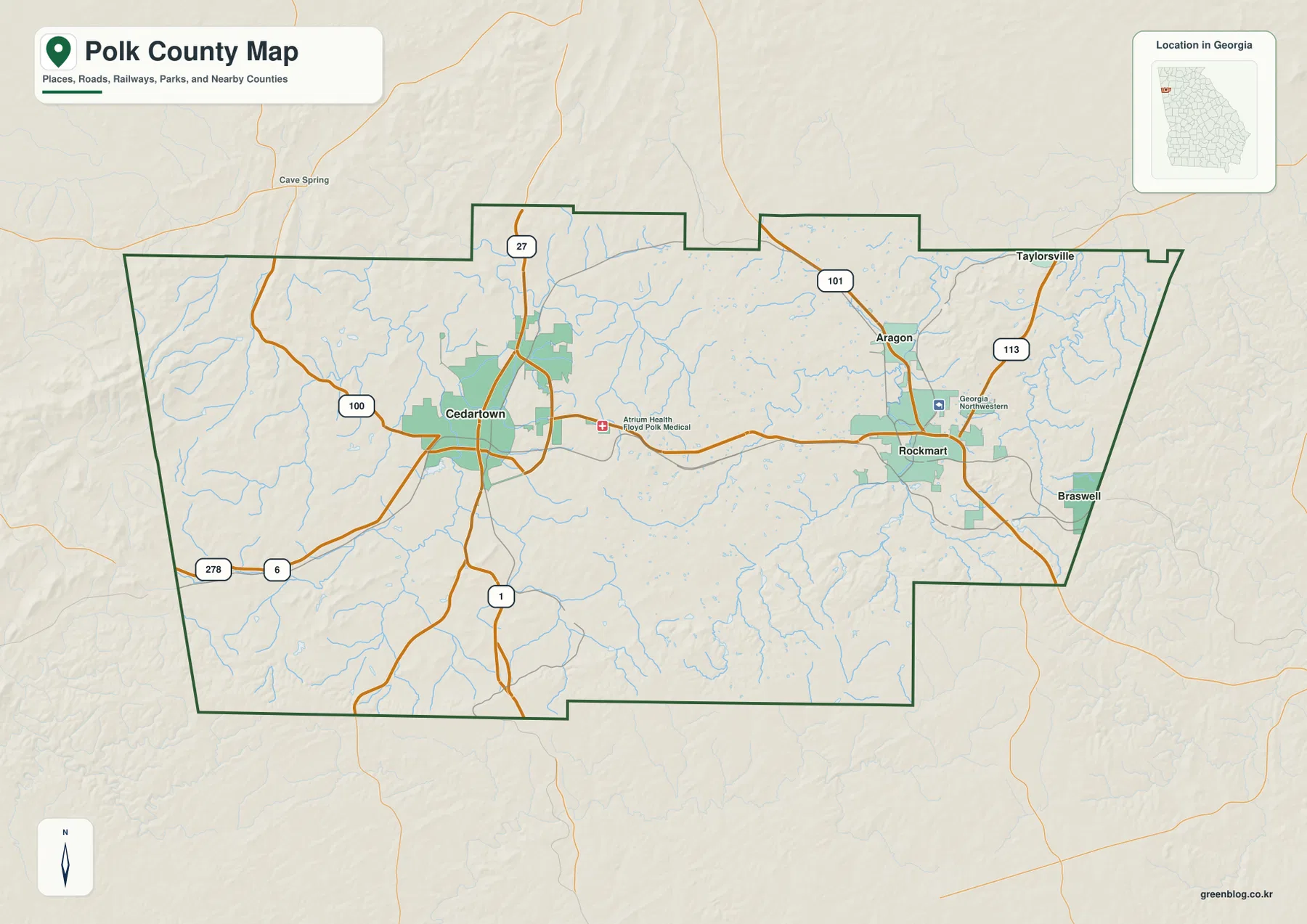
The general county map places Cedartown in the west-central part of Polk County and Rockmart in the east-central part. US 278 and Georgia 6 run across the county between these two areas, making the east-west relationship easy to see. Around Cedartown, US 27, Georgia 100, and Georgia 1 branch in different directions, while Georgia 101 and Georgia 113 are more prominent around Rockmart and Aragon. The result is a road pattern with two clearly visible urban centers rather than a single cluster of routes around one town.
The map also labels nearby places outside the county, including Cave Spring and Taylorsville, which help place Polk County within the surrounding part of Georgia. The county boundary has several steps and indentations, especially along the northern and eastern sides, so the outline is useful when a simple rectangular locator map would be too vague. It is still a county-scale reference: minor local streets, parcel lines, addresses, and every unincorporated community are outside the scope of this map.
Why Rockmart and Aragon both appear about 12 miles from Cedartown
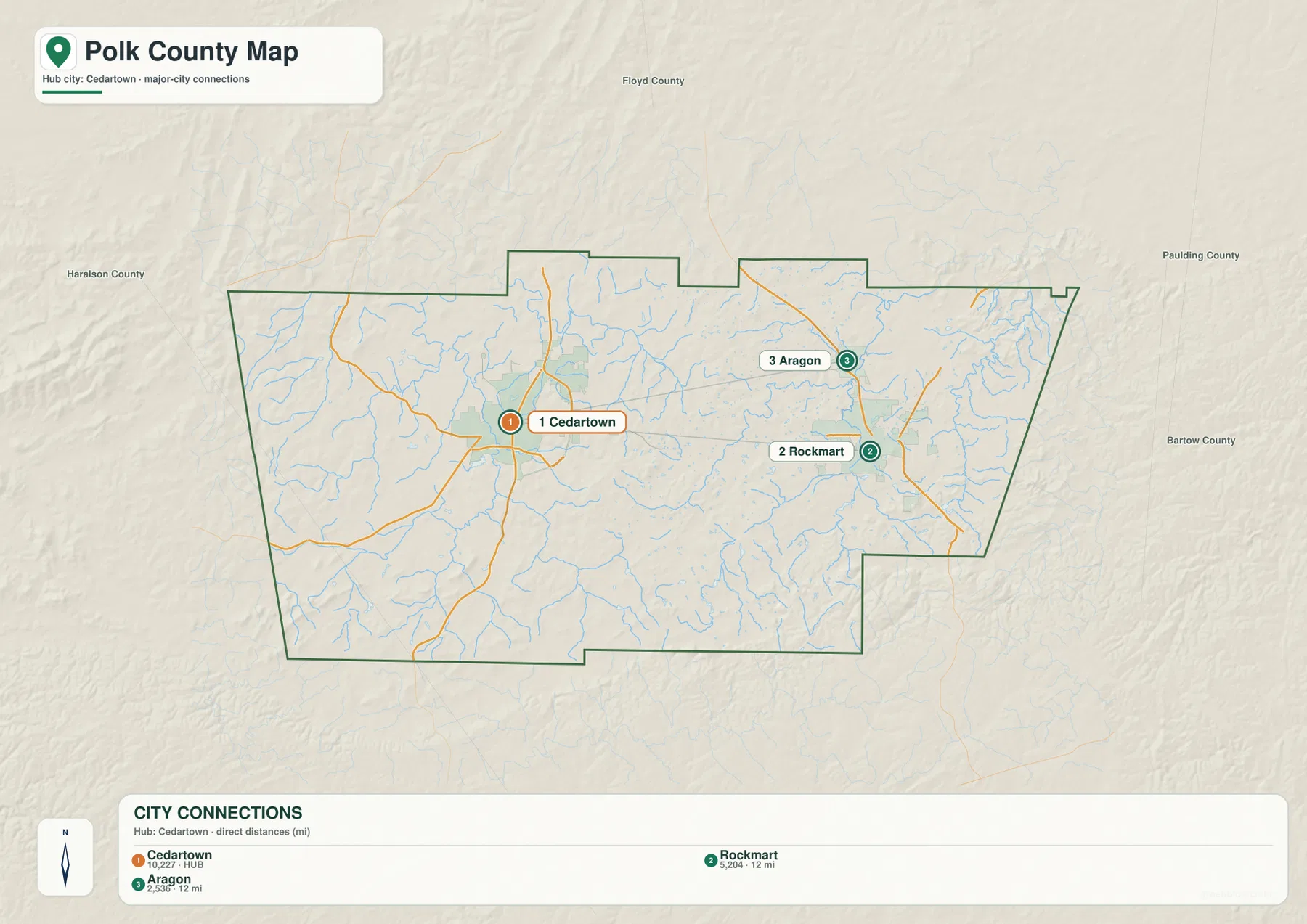
The city-connections map uses Cedartown as the hub and compares two other labeled cities. Rockmart is shown about 12 miles from Cedartown, and Aragon is also shown about 12 miles away. Those similar numbers do not mean the two places occupy the same part of the county. Rockmart lies almost due east of Cedartown, whereas Aragon is farther to the northeast, above Rockmart on the map.
These are straight-line distances, not driving distances. They measure the direct separation between the mapped city points and do not follow highway curves, intersections, or the route a driver would actually take. The city map is therefore most useful for quickly comparing direction and relative spacing. For travel time or turn-by-turn navigation, a current routing service is the appropriate source.
A county divided by many creeks rather than one dominant river
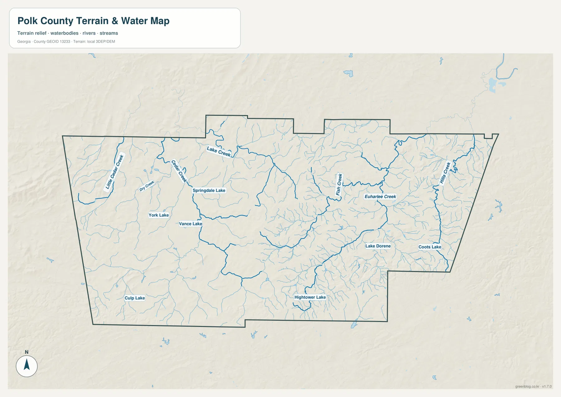
The water map gives Polk County a very different appearance from the road map. In the west, Little Cedar Creek, Cedar Creek, Dry Creek, and Lake Creek form part of a dense network of blue lines. Moving eastward, Fish Creek and Euharlee Creek become important named references, and Hills Creek is labeled near the eastern side. Many smaller unnamed tributaries fill the spaces between them, showing how extensively the county is cut by short stream valleys.
Several lakes are also distributed across the county rather than concentrated in one large reservoir. Springdale Lake, York Lake, and Vance Lake appear on the western half of the map. Lake Dorene and Coots Lake are labeled farther east, while Hightower Lake and Culp Lake provide additional reference points toward the south. This scattered pattern is useful when matching a creek or small lake to the surrounding part of the county.
The water map should be read as a geographic reference, not as a flood map or a legal water-boundary product. It does not show flood zones, water depth, safe access points, navigability, or parcel ownership along the banks. If one of those questions matters for a property or field visit, use the appropriate official dataset for that purpose rather than inferring it from this county overview.
From lower central valleys to ridges above 500 meters
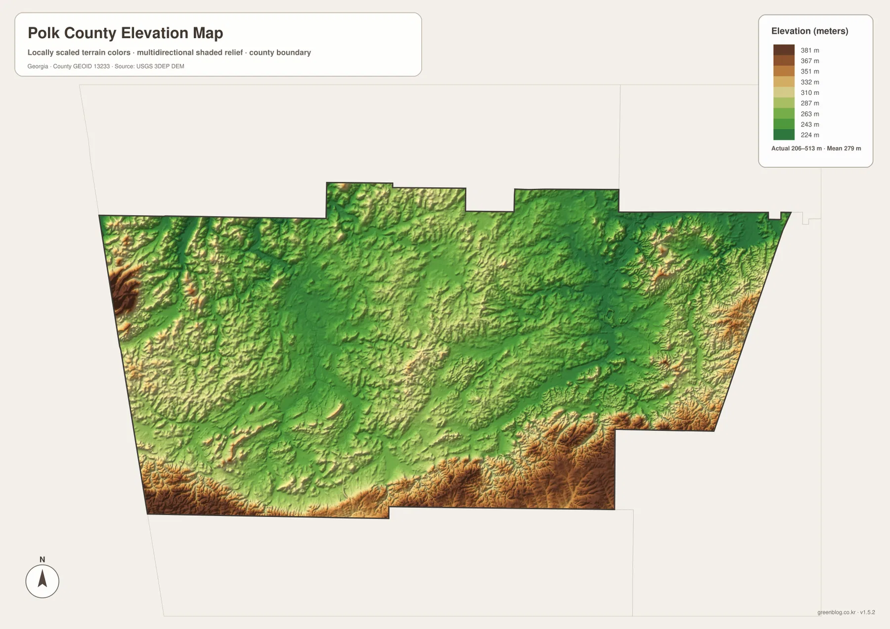
The elevation map lists an actual county range of about 206 to 513 meters, with a mean elevation of 279 meters. Green tones dominate much of the center and northeast, while warmer brown tones mark higher ground along portions of the western edge and the southern side. A particularly strong band of relief appears from the southeast toward the south-central boundary, where ridges stand out sharply against lower interior areas.
Comparing the elevation and water maps helps explain why the stream network looks so branched. Creeks generally occupy lower corridors between ridges, while smaller tributaries descend from higher ground into those corridors. The maps are generalized at county scale, so they are good for recognizing broad terrain differences but not for determining the exact elevation or slope of a building site, trail segment, or parcel.
What changes when the four maps are read together
The county map emphasizes roads, places, and the administrative outline, so Cedartown and Rockmart naturally appear to be the strongest organizing features. The water and elevation maps shift attention away from those city labels. Cedar Creek and its neighboring tributaries occupy the west, Euharlee Creek and Fish Creek help define the eastern interior, and the highest terrain is concentrated along ridges that do not simply follow the main road corridor.
This comparison is especially helpful when a place name alone does not explain the surrounding landscape. A location between Cedartown and Rockmart may be close to a major road while also lying near a creek valley, and another site only a few miles away may sit on noticeably higher ground. The maps do not replace local engineering, property, or navigation data, but they provide a clear first view of how settlement, water, and relief relate across the county.
A county established in 1851 with two enduring city reference points
The supplied Polk County article identifies 1851 as the county’s establishment year and notes manufacturing, railroad history, and the Silver Comet Trail as parts of its broader local background. Those historical details are not encoded directly in the four maps, but they add context for why Cedartown and Rockmart remain useful names when orienting yourself within the county. Cedartown is the county seat and the strongest western road hub on the map, while Rockmart is the main labeled center in the eastern half.
Aragon sits north of Rockmart and is treated as a separate city on the connection map. Braswell appears near the eastern edge on the general county map. Together, these labels show that Polk County cannot be understood only as a circle around Cedartown; its populated references extend eastward across a broad area with different roads, creeks, and terrain.
Choose the map by the question you need to answer
Use the county map when your first question is about boundaries, city locations, or the main numbered roads. The city-connections map is better when you want a quick directional comparison from Cedartown to Rockmart and Aragon. The water map is the strongest choice for named creeks and lakes, while the elevation map makes the south-and-west ridge pattern much easier to see than the other versions.
The WebP images in the article are optimized for on-screen viewing. The downloadable archive contains the four maps as high-resolution A3 JPG files, which are more suitable for printing, enlarged reference, or keeping an offline copy. Because each version removes some information and emphasizes something else, comparing two maps is often more useful than trying to force every question onto a single image.
Frequently Asked Questions
Are the 12-mile Cedartown–Rockmart and Cedartown–Aragon distances driving distances?
No. The city-connections map reports straight-line distances between the mapped city points. A driving route follows actual roads and can therefore be longer, so the 12-mile values should be used for spatial comparison rather than trip planning.
Does the Polk County water map show flood zones?
No. It identifies creeks, tributaries, and several lakes as geographic reference features. Flood hazards, regulatory floodplains, bank ownership, and water depth require separate official sources.
What is included in the Polk County map download?
The ZIP contains four high-resolution A3 JPG files: a county boundary and road map, a city-connections map, a water map, and an elevation map. The WebP images shown in the article are preview versions for the web.
Map File Information
The ZIP includes four high-resolution A3 JPG maps of Polk County: the county map, city-connections map, water map, and elevation map.
- File Type: Four high-resolution A3 JPG files in one ZIP
Related Maps
Sources and References
These sources provide additional county information and the authoritative data families used for boundary, hydrography, and elevation reference.
- U.S. Census Bureau QuickFacts for Polk County, Georgia
- New Georgia Encyclopedia: Polk County
- U.S. Census Bureau TIGER/Line Shapefiles
- USGS National Hydrography
- USGS 3D Elevation Program
Green Map creates custom-edited map images using open geographic data sources such as geoBoundaries, Natural Earth, OpenStreetMap, and government open data. These maps are edited visual materials, not raw data files, and are provided for education, documents, presentations, and graphic reference.