Wells County is centered on Bluffton, with Ossian to the north, Zanesville near the northwestern corner, Uniondale west of the middle, Poneto to the south, and Vera Cruz on the southeastern side. Route 1 provides the clearest north–south road reference through Ossian, Bluffton, and the Petroleum area, while Route 124 crosses the county through Bluffton. The physical maps add Wabash River, Rock Creek, Flat Creek, Big Creek, Eightmile Creek, several small lakes, and a relief surface ranging from about 196 to 285 meters. This Wells County Indiana Map page brings those roads, places, waterways, and terrain differences together. Below, you can download Wells County’s four 2572×3638 high-resolution JPG originals in one ZIP for close inspection or A3 printing.
Bluffton is the easiest fixed point for moving between the maps. Route 1 continues north toward Ossian and south toward Petroleum, Route 124 crosses east–west through the city, and Route 116 approaches from the northwest. Route 224 provides another strong east–west line farther north, while Routes 201 and 301 help place Vera Cruz and the eastern side. Once those roads are familiar, smaller places such as Craigville, Liberty Center, Keystone, and Markle are much easier to locate.
The elevation map shows a stronger terrain contrast than the general road map suggests. Its legend reports an actual range of about 196 to 285 meters and a mean of 255 meters. Lower green ground follows Wabash River and several creek corridors across the north and west-central part of the county, while higher tan and brown ground becomes much more extensive in the south and southeast. The southern extension contains some of the darkest high terrain on the map.
Table of Contents
Bluffton connects Ossian, Poneto, and the eastern road grid
Bluffton is the clearest starting point on the general county map. Route 1 passes through the city from north to south, while Route 124 crosses the county through the same area. Route 116 approaches Bluffton from the northwest, and Route 201 leaves toward the Vera Cruz side. The Wells County Sheriff’s Office is also labeled near Bluffton, providing another visible reference inside the main town area.
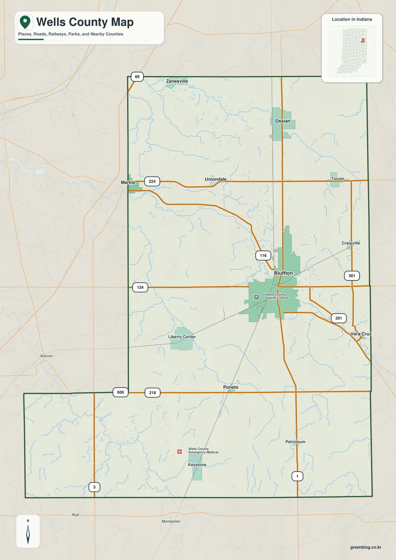
Ossian sits north of Bluffton near Route 1, while Zanesville is separated near the northwestern edge. Route 224 crosses the northern half from the Markle side through Uniondale toward Tocsin. The road spacing is wider here than around Bluffton, but the blue creek network becomes more visible, especially around Flat Creek and Big Creek.
South of Bluffton, Poneto is labeled near Route 218 and Petroleum sits farther south along Route 1. The southwestern extension contains Route 3 and the Keystone area, while Vera Cruz lies to the southeast near Routes 201 and 301. Craigville provides another eastern place reference north of Vera Cruz.
Use the general county view for named places, road directions, and the county boundary. It does not track temporary construction, closures, or current travel restrictions, so actual driving conditions should be checked with a current transportation source.
Bluffton and Ossian anchor six highlighted places across the county
The city view highlights Bluffton, Ossian, Zanesville, Uniondale, Poneto, and Vera Cruz. Bluffton provides the central reference, Ossian and Zanesville occupy the north, Uniondale lies west of the middle, Poneto sits farther south, and Vera Cruz marks the southeast. The simplified distribution makes the county’s long north–south shape and scattered outer communities easier to see than the full road map does.
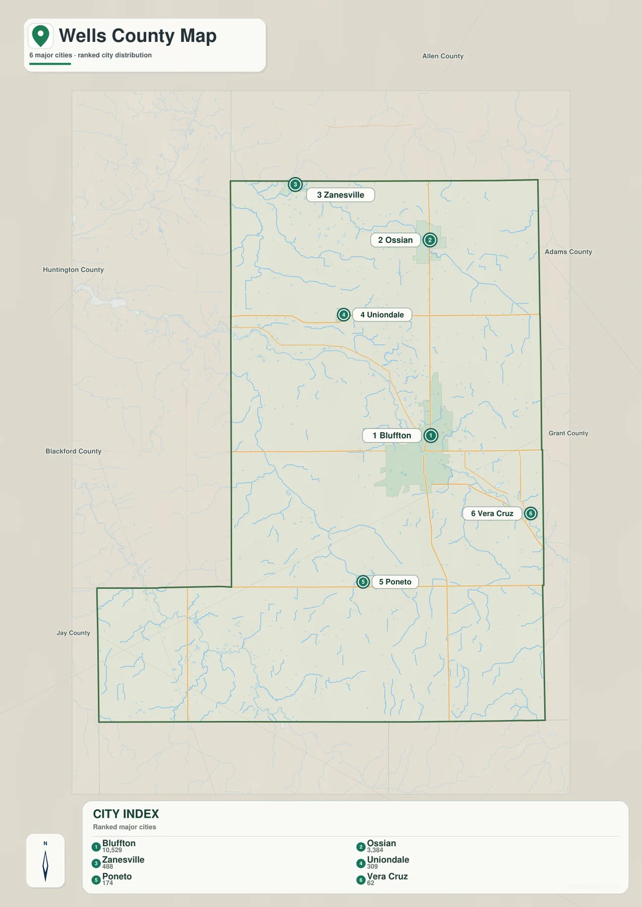
The Wells County CITY INDEX also prints numeric values beside the six place names, but the supplied graphic does not identify the year those figures represent or cite a separate statistical source. This page therefore does not present them as current official population. A recent U.S. Census release should be used when up-to-date population counts are needed.
Allen County is labeled to the north, Adams County to the east, Grant County toward the southeast, and Blackford, Jay, and Huntington counties around the west and southwest. Those neighboring names help explain the county’s irregular southwestern extension and make the edge locations of Zanesville and Vera Cruz easier to place.
The settlement pattern also provides a useful guide to the water map. Flat Creek and Big Creek occupy the northern side between the Zanesville–Ossian area and the central interior. Wabash River and Rock Creek lie west of Bluffton, while Johns Creek and Sixmile Creek provide separate eastern and southeastern drainage references.
Wabash River and the creek network divide the county into several low corridors
Wabash River is the strongest named water feature in the west-central part of the terrain-and-water map. Rock Creek forms another long corridor south of it, while Flat Creek and Big Creek occupy the northwestern and northern interior. Eightmile Creek stretches across the northeastern side and gives the eastern half a separate drainage reference.
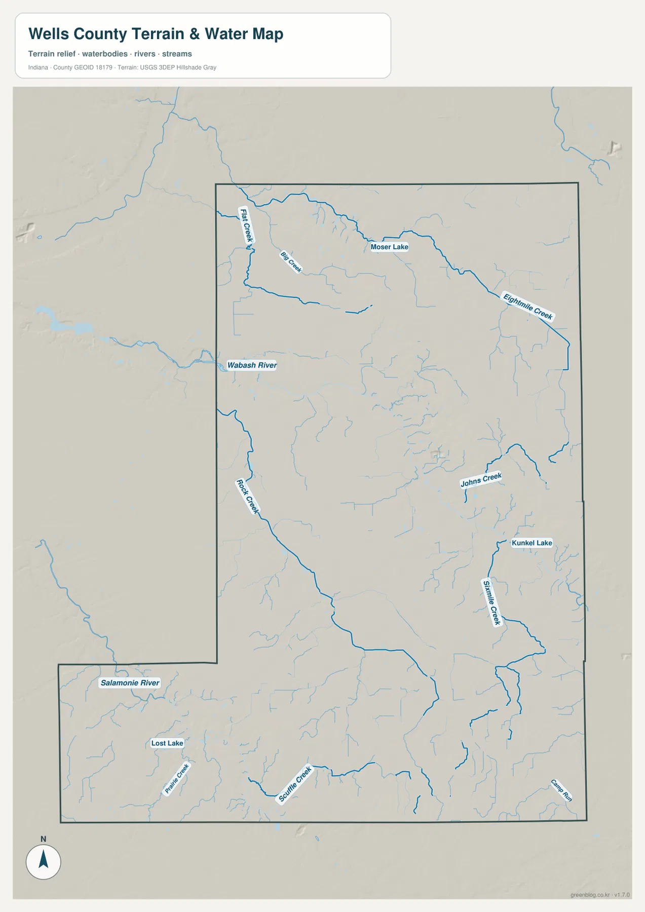
Moser Lake is labeled in the north between the Big Creek and Eightmile Creek areas. Farther south and east, Johns Creek bends through the interior and Kunkel Lake appears as a separate small-water reference beside the Sixmile Creek system. These lakes are shown independently rather than as one connected lake group.
The southwestern extension has its own water pattern. Salamonie River appears near the western edge, Lost Lake is labeled farther inside, and Prairie Creek and Scuffle Creek cross the southern terrain. Camp Run is marked near the southeastern edge. Those features make the southern extension much more detailed on the water map than it appears on the road view.
Use this hydrology view to locate Wells County rivers, creeks, runs, and lakes at county scale. For Wells County, this water overview is only a location reference; flood boundaries, parcel limits, legal water lines, channel depth, and navigation conditions require the current agency records created for those purposes.
The 196–285 meter surface rises toward the south and southeast
The elevation legend gives Wells County an actual range of about 196 to 285 meters and a mean of 255 meters. Lower green terrain follows Wabash River and several northern and west-central creek corridors. Tan and brown ground becomes much more extensive across the south and southeast, with the southern extension containing some of the county’s highest-looking terrain.
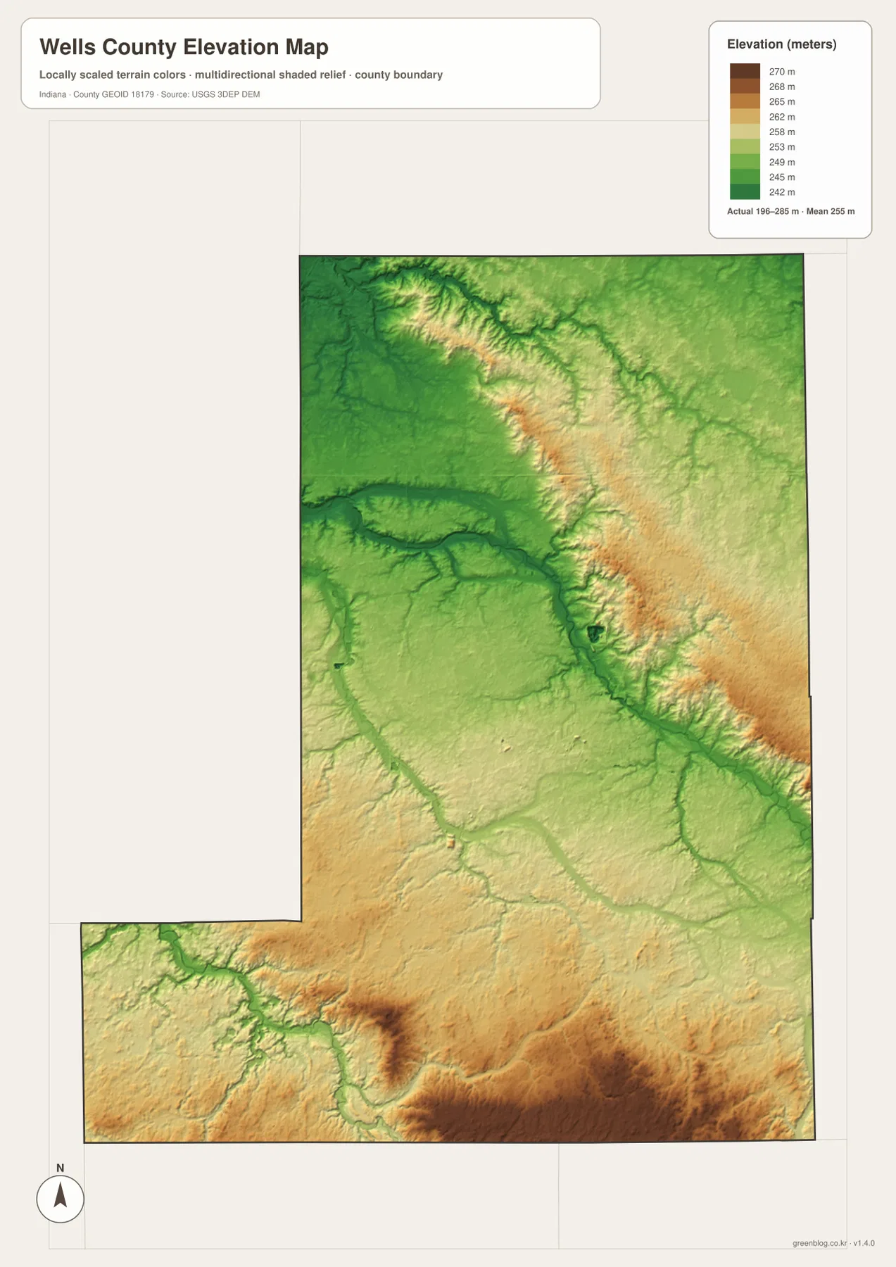
The northern half is not completely flat. Big Creek and Eightmile Creek create lower green corridors between gently higher ground, and several narrow ridges appear between the channels. The west-central Wabash corridor is broader and lower, making it easy to match the relief image with the water map.
In the south, Salamonie River and Prairie Creek cut lower paths through otherwise higher terrain. Farther southeast, the relief rises again into darker brown ground. Wells County is therefore better understood as a mix of higher southern and eastern surfaces separated by lower river-and-creek corridors than as a smooth slope in one direction.
The relief image is intended for broad countywide comparison rather than surveyed point elevations. For an exact height at a Wells County building, road point, field, or parcel corner, use the underlying elevation dataset or a professional survey.
Keep Bluffton fixed while comparing roads, water, and elevation
For basic orientation, start with Bluffton, Ossian, Route 1, Route 124, and Route 224. The city view is cleaner when the goal is simply to compare Zanesville, Uniondale, Poneto, and Vera Cruz around the central town. Once those locations are familiar, Craigville, Keystone, Petroleum, and other smaller places are easier to find.
For the physical landscape, locate Wabash River and Rock Creek first, then add Flat Creek, Big Creek, Eightmile Creek, Johns Creek, and Sixmile Creek. Open the elevation map at the same locations and the relationship becomes clear: lower green corridors follow the main waterways, while the southern and southeastern parts of the county rise into higher ground.
The page uses smaller WebP previews for quick browser viewing. For Wells County, the ZIP preserves four full-resolution JPG originals—general county, city, terrain-and-water, and elevation—at 2572 by 3638 pixels each. Those files retain more detail for A3 output and for zooming in on road numbers, creek names, lake labels, and smaller places.
A practical comparison routine is to keep Bluffton fixed, follow Route 1 north and south, trace Wabash River and Rock Creek on the water view, and finish by comparing the lower green corridors with the higher southern and southeastern terrain.
Frequently Asked Questions
What is the easiest place to use as a starting point on the Wells County maps?
Bluffton is the best starting point because Route 1 and Route 124 provide clear north–south and east–west references. From Bluffton, Ossian, Poneto, Vera Cruz, and the outer road network become much easier to place.
Do the numbers in the Wells County city index represent current population?
The supplied city graphic lists numeric values with Bluffton, Ossian, Zanesville, Uniondale, Poneto, and Vera Cruz, but it does not state a statistical year or cite a separate source. This page therefore does not present those values as current official population. Use a recent U.S. Census release when current population figures are needed.
Where does the elevation map show the highest-looking terrain?
The broadest high tan-brown terrain appears across the south and southeast, especially in the southern extension, while Wabash River and several creek corridors remain lower. The legend reports an actual elevation range of about 196–285 meters and a mean of 255 meters.
Map File Information
The ZIP contains the high-resolution JPG originals for Wells County’s general, city, terrain-and-water, and elevation views. Use the Wells County JPG originals when you need a closer look at route numbers, creek labels, lake names, or when preparing an A3 print.
- Printable Size: 2572×3638 px each
Related Maps
Sources and References
The place, road, water, and elevation descriptions above are based on the supplied Wells County maps and asset information. The references below provide official county information and source data for readers who need more detail.
- Wells County Government – official county government and local information
- U.S. Census Bureau TIGER/Line Shapefiles – official geometry for county boundaries, roads, and named places
- USGS National Hydrography – source information for Wells County rivers, creeks, runs, and lakes
- USGS 3D Elevation Program – elevation-source information for the county relief surface
Green Map creates custom-edited map images using open geographic data sources such as geoBoundaries, Natural Earth, OpenStreetMap, and government open data.
These maps are edited visual materials, not raw data files, and are provided for education, documents, presentations, and graphic reference.