Sherman County lies along the far western side of Kansas, where Goodland anchors a broad High Plains landscape and Kanorado sits close to the Colorado line. Interstate 70, US 24, and K-27 make Goodland the county’s clearest transportation reference. Beaver Creek tributaries cut across the northern and central uplands, while the North Fork Smoky Hill River forms a separate southern corridor. The terrain also drops noticeably from the high western plains toward lower eastern drainage valleys. High-resolution map files are available for download in the section below.
This guide follows Goodland and Kanorado across the road, water, and elevation views, with terrain ranging from about 1,000 to 1,222 meters. WebP previews are available for quick viewing, and the matching high-resolution JPG files can be downloaded together in one ZIP for printing, classroom work, or offline reference.
Table of Contents
Goodland anchors the county where I-70, US 24, and K-27 meet
Goodland sits slightly south of the county’s center and serves as the strongest road reference in Sherman County. Interstate 70 crosses the area east–west, US 24 follows the broader Goodland corridor, and K-27 provides a north–south route through the city. These roads connect the Colorado-border side near Kanorado with Ruleton, Goodland, Edson, and points farther east.
Sherman County government is based in Goodland, and City of Goodland history describes a fierce county-seat contest in 1887 involving Goodland, Sherman Center, Eustis, and Voltaire. Goodland ultimately secured the county seat, and the modern map still shows how government, roads, rail lines, and urban development concentrate in the same place.
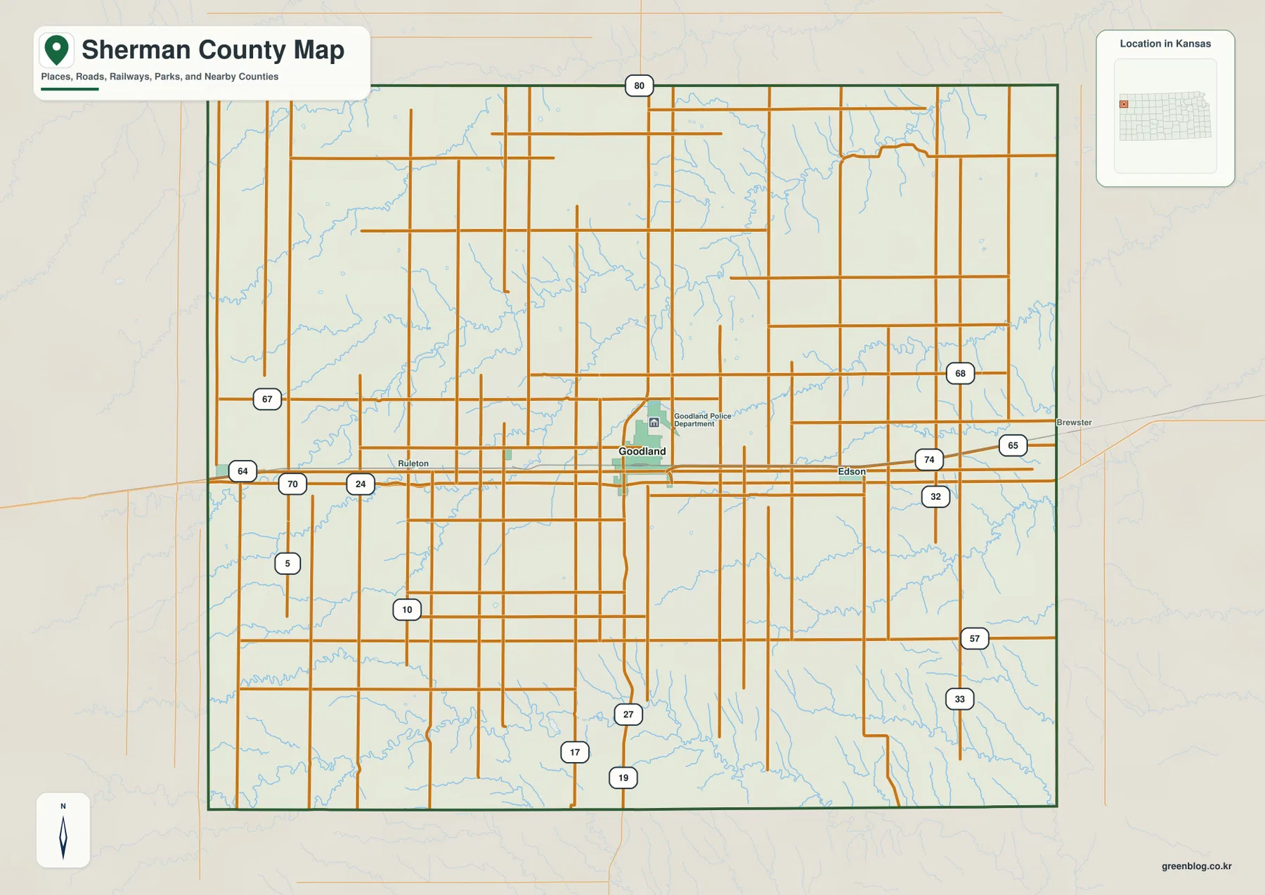
Outside Goodland, settlement becomes sparse very quickly. Ruleton lies to the west and Edson to the east, while large parts of the northern and southern county are agricultural High Plains where road junctions and stream valleys provide more useful location cues than town centers.
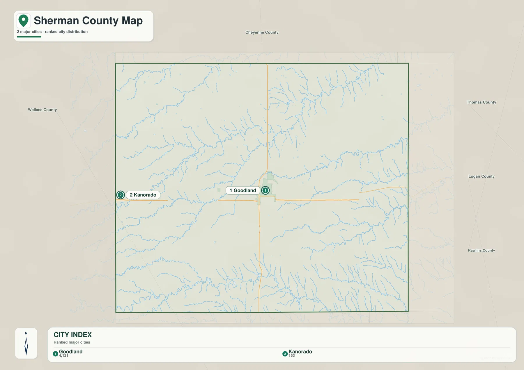
The city panel contains only Goodland and Kanorado
The ranked city panel lists Goodland at 4,121 and Kanorado at 153. These are map index values rather than current official population estimates, but they clearly show how strongly Sherman County’s settlement is concentrated in Goodland.
Kanorado sits near the Colorado boundary and remains much smaller than Goodland. The two communities share the broad I-70 and US 24 transportation corridor, but long stretches of farms, local roads, and creek-cut terrain separate the county’s western edge from its administrative center.
Goodland’s central role also reflects railroad and county-seat history. City museum material explains how the community grew rapidly in the late 1880s as buildings, records, and businesses shifted from rival settlements toward the new county seat.
Beaver Creek forks cut deeply into the northern and central High Plains
The water map is dominated by the Beaver Creek system. Middle Beaver Creek enters from the west and runs toward the central county, while South Beaver Creek continues through the interior and South Fork Beaver Creek creates a distinct northeastern valley. Little Beaver Creek adds a smaller drainage along the northwestern edge.
Farther east, Middle Fork Sappa Creek forms another long corridor across the east-central part of the county, and South Fork Sappa Creek cuts through the southeast. Sappa Creek and Sandy Creek provide additional drainage references in the southwest.
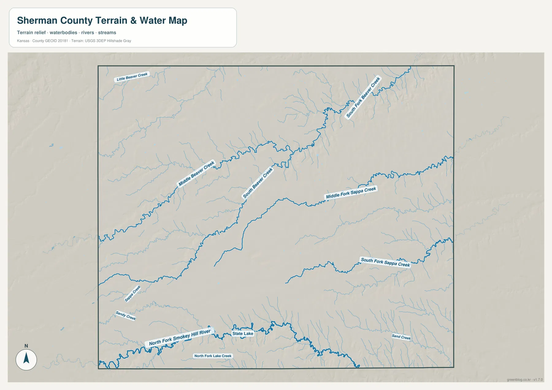
Along the southern side, the North Fork Smoky Hill River forms a separate west–east low corridor. State Lake and North Fork Lake Creek appear nearby, while Sand Creek drains the southeastern area. The combination of Beaver, Sappa, and Smoky Hill tributaries gives Sherman County several distinct drainage zones rather than one dominant river valley.
This image is intended for geographic reference rather than floodplain, navigation, water-quality, parcel, or legal-access decisions. Water levels and channel conditions can change, so current agency information should be used whenever safety or access matters.
Elevation from 1,000 to 1,222 meters falls sharply from west to east
The elevation surface ranges from about 1,000 to 1,222 meters, with a mean near 1,114 meters. Brown and tan high ground dominates the west and southwest near the Colorado side, while greener lower terrain becomes more extensive toward the eastern and northeastern drainage valleys.
Middle Beaver Creek and South Beaver Creek cut clear lower corridors through the central and northern uplands. The North Fork Smoky Hill River forms another long low band across the south, and numerous short tributaries carve narrow valleys into the high western plain.
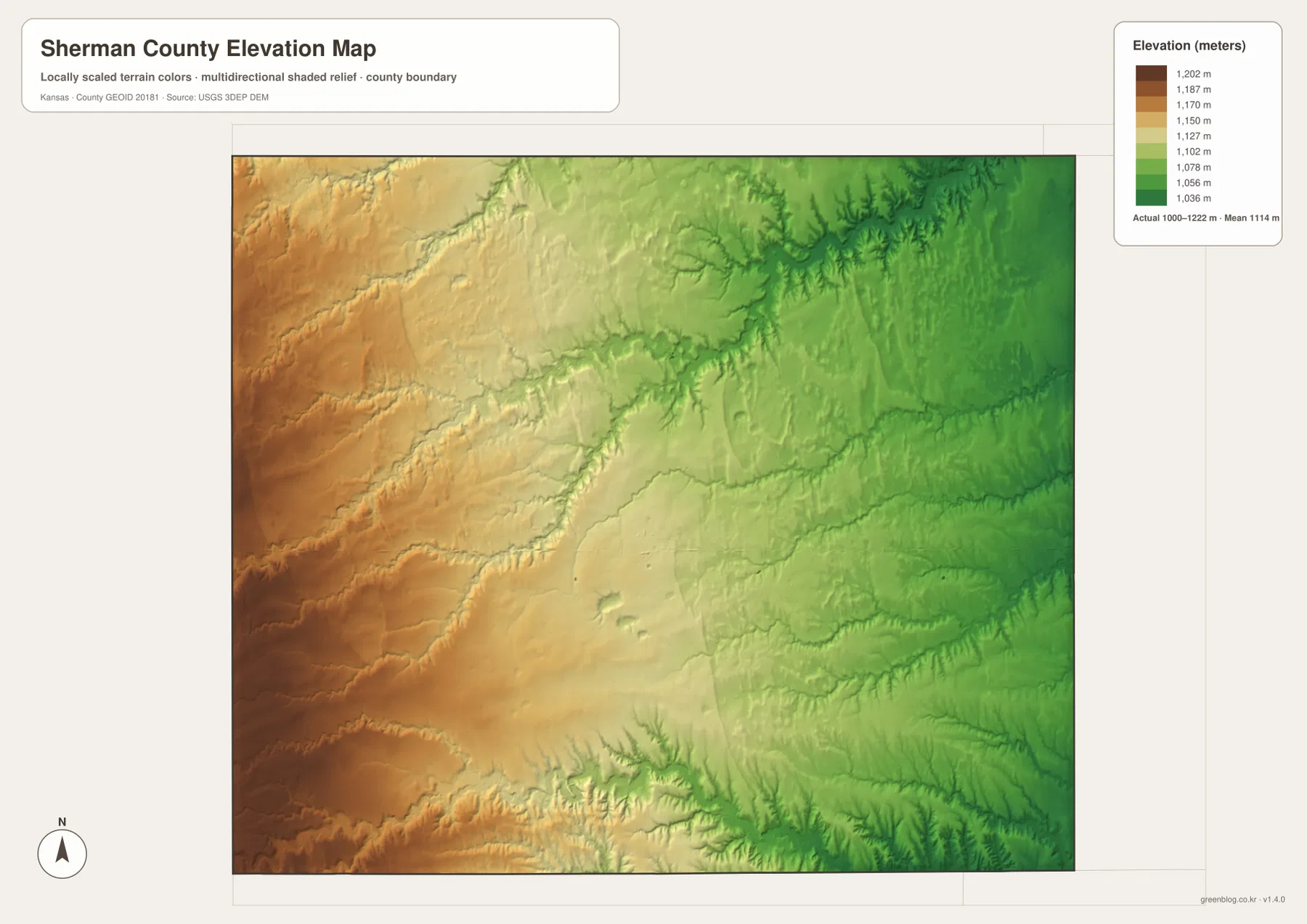
Goodland stands on broad intermediate terrain rather than at either elevation extreme. Traveling west toward Kanorado generally gains elevation, while moving east toward Edson and the Sappa drainage brings more connected low valleys into view.
The elevation surface is generalized for county-scale comparison. It is not survey-grade or engineering-grade measurement and should not be used for parcel elevations, construction grades, drainage design, or legal boundary work.
The High Plains Museum preserves Goodland and Sherman County history
The City of Goodland operates the High Plains Museum as a local history institution for Goodland, Sherman County, and the surrounding High Plains. The museum was approved in 1959, opened in 1960, and now preserves more than 8,000 objects connected with Native American history, settlement, railroads, agriculture, and community life.
For map readers, the museum adds context to the otherwise simple-looking county pattern. Goodland’s road concentration and county-seat role are products of settlement and transportation history, not just the geometric center of a rectangular western Kansas county.
Goodland’s Big Easel turns sunflower agriculture into a landmark
Pioneer Park in Goodland contains a giant Van Gogh sunflower reproduction created as part of Cameron Cross’s Van Gogh Project. City material dates the installation to 2001 and describes a 24-by-32-foot painting mounted on an approximately 80-foot steel easel.
Goodland was selected in part because of the area’s connection with sunflower agriculture. The artwork is not a terrain feature, but it provides a memorable local reference that links the High Plains farming landscape with the city’s public identity.
From Kanorado through Goodland, the High Plains gradually break into eastern valleys
Traveling east from Kanorado begins on some of the county’s highest ground. The landscape remains broad and open toward Goodland, but farther east the Beaver and Sappa systems create increasingly visible lower corridors and more heavily dissected terrain.
The southern comparison is different: the North Fork Smoky Hill River creates a separate lowland that runs across the bottom of the county. Viewing the road, water, and elevation maps together therefore reveals three useful geographic zones — high western plains, creek-cut eastern terrain, and the southern Smoky Hill corridor.
For posters, classroom prints, or presentation slides, use the original JPG files in the download archive rather than enlarging the web previews. Small road labels, creek names, community text, and the elevation legend remain clearer at the higher resolution.
Frequently Asked Questions
Why does the city map show only Goodland and Kanorado?
The supplied ranked-city dataset contains two entries for Sherman County: Goodland at 4,121 and Kanorado at 153. Smaller place names such as Ruleton and Edson can appear on the general map, but they are not part of the ranked city panel.
Where is the county’s strongest elevation change?
The western High Plains near the Colorado side are the highest, while the Beaver and Sappa creek systems and the North Fork Smoky Hill River create lower terrain farther east and south. The full mapped range is about 1,000–1,222 meters.
Can the 1,000–1,222 meter elevation image be used for surveying?
No. It is a generalized county-scale terrain image for comparing high western plains with lower creek and river valleys. Parcel elevations, engineering grades, drainage design, and legal boundary work require more precise official data and, where needed, professional surveying.
Map File Information
The archive contains the Sherman County, Kansas general county map, city map, terrain-and-water map, and elevation map as original high-resolution JPG files.
- Included Files: Use only the versions confirmed in the article and supplied images
- File Type: Use the confirmed download contents
- Intended Use: Printing, education, presentations, and map-based projects
Related Maps
Sources and references
- Sherman County, Kansas official government website — county administration and Goodland county-seat context
- City of Goodland: Why is Goodland the County Seat? — 1887 county-seat competition and Goodland history
- City of Goodland: High Plains Museum — Sherman County and northwestern Kansas history collections
- City of Goodland: Goodland’s Big Easel — Van Gogh Project and sunflower landmark information
- USGS National Hydrography — river and stream reference data
- USGS 3D Elevation Program — elevation and terrain reference data
Green Map creates custom-edited map images using open geographic data sources such as geoBoundaries, Natural Earth, OpenStreetMap, and government open data. These maps are edited visual materials, not raw data files, and are provided for education, documents, presentations, and graphic reference.