Johnson County forms the southwestern side of the Kansas City metropolitan area and contains one of the clearest urban-to-rural contrasts in Kansas. Olathe is the county seat, while Overland Park is the largest city shown on the map. Shawnee, Lenexa, Leawood, and Gardner add major population centers, and I-35, I-435, K-10, and U.S. 69 connect a dense eastern suburban network with the more open west and southwest. High-resolution JPG versions of the maps can be downloaded together from the ZIP box below. High-resolution map files are available for download in the section below.
The natural landscape is just as varied. The Kansas River follows the northern and northwestern edge, while Mill Creek, Kill Creek, and Cedar Creek cut through the central and western uplands. Indian Creek and the Blue River create lower corridors through the eastern urban area. Olathe Lake, Gardner Lake, Cedar Lake, and Park Lake add smaller water references. Elevation ranges from about 225 to 349 meters with a mean near 300 meters.
The Kansas Historical Society records Johnson County as one of the original Kansas counties established in 1855 and identifies Olathe as the county seat. The county was once part of the Shawnee Indian Reservation, and the Shawnee Indian Mission, major westward trails, Bleeding Kansas conflicts, rail development, wartime industry, and postwar suburbanization all shaped the landscape seen today. The modern map therefore combines metropolitan growth with much older transportation and settlement geography.
Table of Contents
I-35 and K-10 connect Olathe with the wider metropolitan area
Olathe sits slightly south of the county center and provides the clearest administrative reference. I-35 enters from the Gardner side, passes through Olathe, and continues northeast toward Lenexa and Merriam. K-10 runs from De Soto across the western county toward Lenexa, while U.S. 69 forms a major north-south route through the Overland Park side. I-435 ties together the northeastern suburban network.
The eastern side of the county is a nearly continuous patchwork of city boundaries: Overland Park, Leawood, Prairie Village, Mission, Merriam, Roeland Park, Shawnee, and Lenexa occupy much of the area. West of that urban belt, De Soto, Gardner, and Edgerton are separated by larger tracts of open land. Road spacing widens noticeably as the map moves away from the metropolitan core.
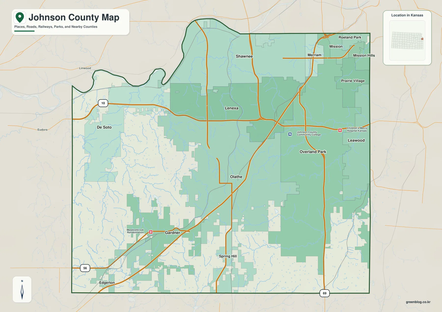
De Soto is a useful western reference near K-10 and the Kansas River, while Gardner and Edgerton organize the southwestern I-35 and U.S. 56 corridor. Spring Hill sits near the southern boundary and helps orient travel toward Miami County. The map is designed for county-scale understanding rather than live navigation, so construction, congestion, and temporary detours should be checked through current transportation sources.
Overland Park is largest, but Olathe remains the county seat
The city distribution map ranks Overland Park first and Olathe second, followed by Shawnee, Lenexa, Leawood, and Gardner. The displayed values are 200,306 for Overland Park, 145,057 for Olathe, 68,542 for Shawnee, 58,384 for Lenexa, 33,809 for Leawood, and 24,526 for Gardner. These figures reflect the source used for the map and may differ from later estimates.
This ranking highlights an important feature of Johnson County: population and county administration are not concentrated in the same city. Overland Park is the largest urban center, while Olathe contains the county seat and major government offices. Shawnee and Lenexa fill much of the north-central suburban area, Leawood sits near the Missouri line, and Gardner anchors the growing southwest.
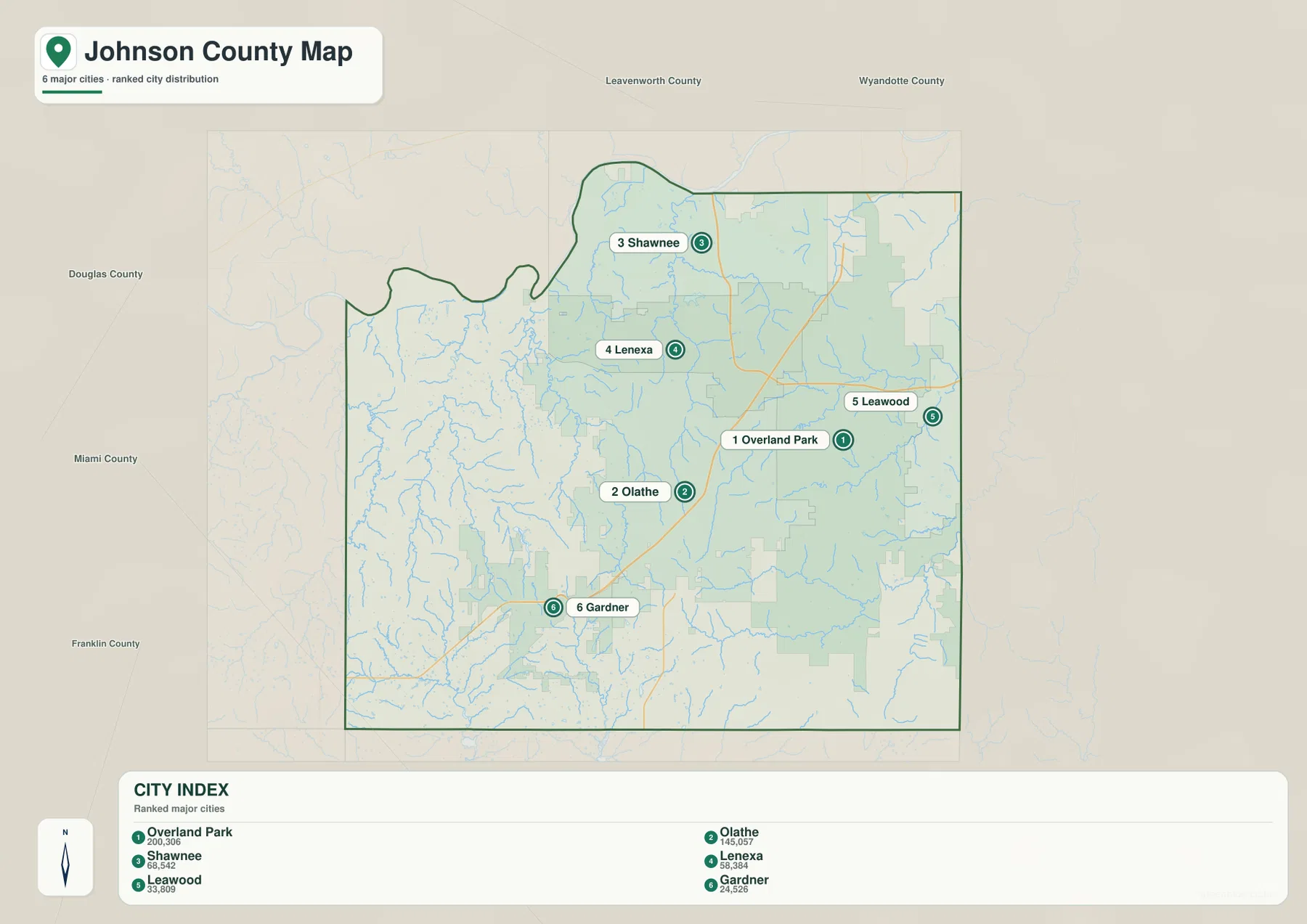
The Kansas Historical Society lists Olathe as the county seat, and Johnson County’s Administration Building is also located there. Reading the city map with that fact in mind prevents a common assumption that the largest city must also be the administrative center.
The Kansas River and western creeks form the broadest lowlands
The Kansas River is the largest water feature touching Johnson County and follows much of the northern and northwestern edge. Near De Soto and west of Shawnee, the river occupies some of the lowest terrain on the map. Captain Creek and Kill Creek drain the western rural landscape toward the river system, while Mill Creek cuts northward through the Shawnee and Lenexa area.
Cedar Creek runs through the central-western county and helps define the lower terrain west of Olathe. Olathe Lake and Cedar Lake appear nearby, while Gardner Lake provides another clear reference farther southwest. These smaller lakes and creek valleys are especially noticeable in the less urbanized half of the county, where the surrounding ridges and open land remain visible.
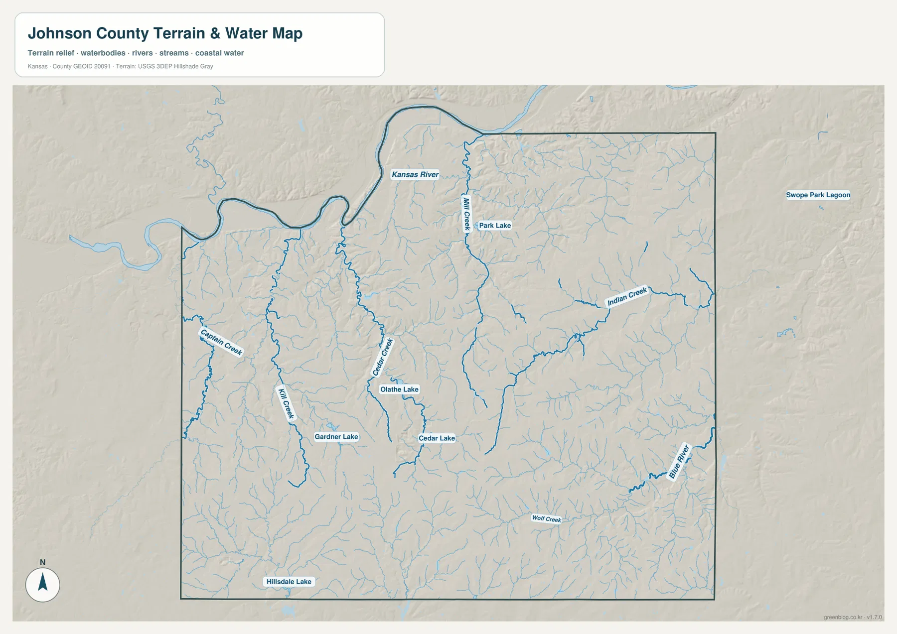
Indian Creek is one of the strongest eastern urban drainages and crosses the Overland Park and Leawood side before continuing toward the Blue River system. The Blue River itself follows the eastern edge, and Wolf Creek crosses the southeast. Park Lake is also labeled in the north-central area. These waterways are useful geographic references, but the map is not a live flood, streamflow, or water-quality product.
Elevation ranges from 225-meter river bottoms to 349-meter uplands
Johnson County ranges from approximately 225 to 349 meters in elevation and averages near 300 meters. The lowest dark-green terrain follows the Kansas River across the north and northwest. Lower corridors also appear along the Blue River and Indian Creek, while central and southern uplands around and south of Olathe rise into tan, orange, and brown colors.
Mill Creek, Kill Creek, and Cedar Creek carve narrow green valleys through otherwise higher terrain. The eastern suburbs are heavily developed, but the elevation surface shows that they are not flat: Indian Creek and the Blue River repeatedly cut into ridges beneath the street network. The southern county is especially rolling, with closely spaced tributaries dividing the higher ground.
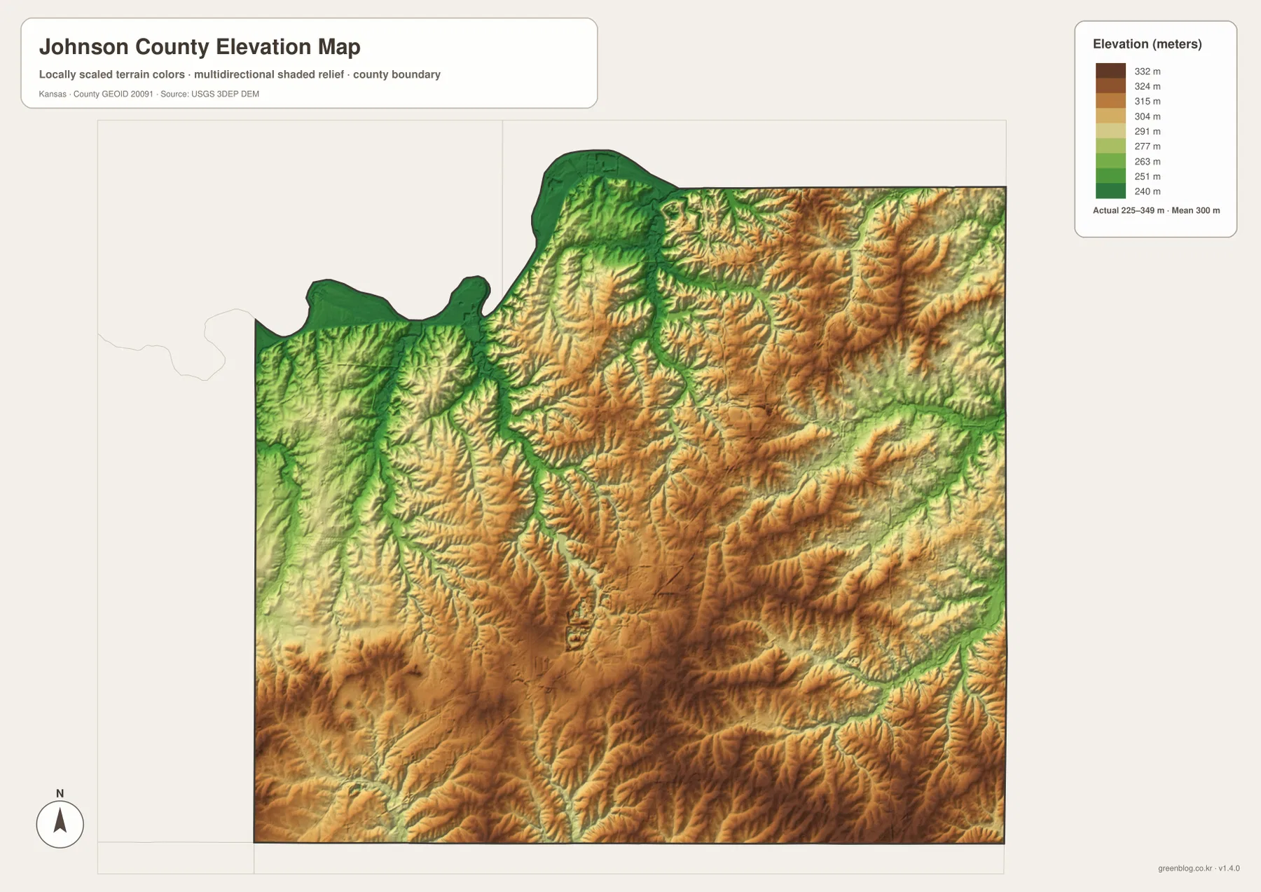
This surface is intended for county-scale comparison rather than survey-grade measurement. It should not be used to establish exact parcel elevations, design drainage, or replace engineering and legal survey data. Its main value is showing that more than 120 meters separate the mapped minimum from the highest uplands, despite the county’s strongly suburban appearance.
A dense urban east gives way to a more open rural west
Few Kansas counties show an internal land-use contrast as clearly as Johnson County. The eastern half contains continuous city boundaries, dense streets, hospitals, offices, neighborhoods, and major highways. Moving west toward De Soto or southwest toward Gardner and Edgerton, development becomes less continuous and agricultural or open land occupies much larger areas.
The Kansas Historical Society links this modern pattern to several waves of transportation and employment growth. The Strang Line connected the area more closely with Kansas City in the early twentieth century, and World War II brought the Olathe Naval Air Station and Sunflower Ordnance Works. Postwar suburban housing and office development then accelerated growth across eastern Johnson County.
That growth is still visible in the modern map. Overland Park, Lenexa, Shawnee, and Leawood form a dense metropolitan block, while western creek valleys and the southwest retain more open space. The contrast between those two settings is one of the most useful ways to understand Johnson County before focusing on individual streets or neighborhoods.
Shawnee Mission and three major westward trails add historical depth
Johnson County was once part of the Shawnee Indian Reservation, and the county name honors Reverend Thomas Johnson, who established a mission to the Shawnee in 1829. The Shawnee Indian Mission in present-day Fairway remains one of the county’s best-known historic sites and reflects a much older geography than the current suburban street network.
The Santa Fe, Oregon, and California trails also passed through the county. Travelers moving west from the Kansas City area crossed what are now parts of Olathe and Gardner before continuing across the plains. The Lone Elm Campground Swale preserves evidence of those routes and shows that Johnson County was an important travel corridor long before interstate highways.
Its position next to Missouri also placed the county inside the violence of Bleeding Kansas and the Civil War. Olathe was raided by Quantrill’s men in 1862, and Spring Hill was attacked the following year. Those events provide a striking contrast with the highly developed metropolitan county visible today.
Using the map files for metropolitan and terrain comparison
For road orientation, begin with Olathe and Overland Park, then follow I-35, K-10, and U.S. 69 to place Shawnee, Lenexa, Gardner, and De Soto. For physical geography, start with the Kansas River and Mill Creek in the north, then compare Kill Creek and Cedar Creek in the west with Indian Creek and the Blue River in the east.
The high-resolution JPG files in the ZIP are better suited than the reduced web previews for printing, classroom work, metropolitan-versus-rural comparison, local-history projects, and close inspection of labels. Current traffic, live stream conditions, parcel boundaries, and exact elevations should always be checked against the latest authoritative sources when those details matter.
Frequently Asked Questions
Are the largest city and county seat the same place in Johnson County?
No. Overland Park is the largest city shown on the map, while Olathe is the county seat. Johnson County’s principal government offices are based in Olathe, so population rank and administrative role should be treated separately.
Where do the Kansas River and Blue River lie in the county?
The Kansas River follows the northern and northwestern edge near De Soto and Shawnee, creating the broadest lowland. The Blue River runs near the eastern edge, where Indian Creek and several smaller urban streams feed into the lower terrain.
What does the 225–349 meter elevation map show most clearly?
It shows the strongest contrast between the low Kansas River and major creek valleys and the higher central and southern uplands around and south of Olathe. The surface is useful for regional comparison, but exact parcel or engineering elevations require more precise data.
Map File Information
Download the high-resolution JPG files corresponding to the Johnson County general, city distribution, terrain-and-water, and elevation maps in one ZIP archive.
- Included Files: Use only the versions confirmed in the article and supplied images
- File Type: Use the confirmed download contents
- Intended Use: Printing, education, presentations, and map-based projects
Related Maps
Sources and references
- Johnson County, Kansas official website — county government and local administrative information
- Johnson County Administration Building — county government seat in Olathe
- Kansas Historical Society — Johnson County, Kansas — county history, Shawnee Mission, westward trails, and postwar growth
- Johnson County AIMS — Watersheds Map — Kansas River, Mill Creek, Kill Creek, Blue River, lakes, and drainage references
- U.S. Census Bureau TIGER/Line — boundary, road, and geographic data resources
- USGS 3D Elevation Program — elevation data information
Green Map creates custom-edited map images using open geographic data sources such as geoBoundaries, Natural Earth, OpenStreetMap, and government open data.
These maps are edited visual materials, not raw data files, and are provided for education, documents, presentations, and graphic reference.