Smith County lies along the Nebraska border in north-central Kansas, with Smith Center serving as the main administrative and road reference. Kensington, Lebanon, Gaylord, Athol, and Cedar are spread across a broad rural landscape rather than one continuous urban corridor. US 36 crosses the central county, US 281 connects the Smith Center area with the south, and the North Fork Solomon River creates a wide low valley across the southern tier. High-resolution map files are available for download in the section below.
This guide follows Smith Center and the surrounding communities across the road, water, and elevation views, with terrain ranging from about 457 to 665 meters. WebP previews are available for quick viewing, and the matching high-resolution JPG files can be downloaded together in one ZIP for printing, classroom work, or offline reference.
Table of Contents
Smith Center anchors the county along the US 36 corridor
Smith Center sits near the middle of the county and is the clearest reference for local roads and services. US 36 provides the principal east–west route, while US 281 reaches south from the Smith Center area. County roads and smaller state highways spread outward toward Kensington, Lebanon, Gaylord, and the surrounding agricultural townships.
The Kansas Historical Society records a contested early county-seat history. Cedarville first won an election, but accusations of irregularities led to another vote, and Smith Center became the permanent county seat. The modern map reflects that outcome: public facilities and road connections are more concentrated around Smith Center than around the smaller communities.
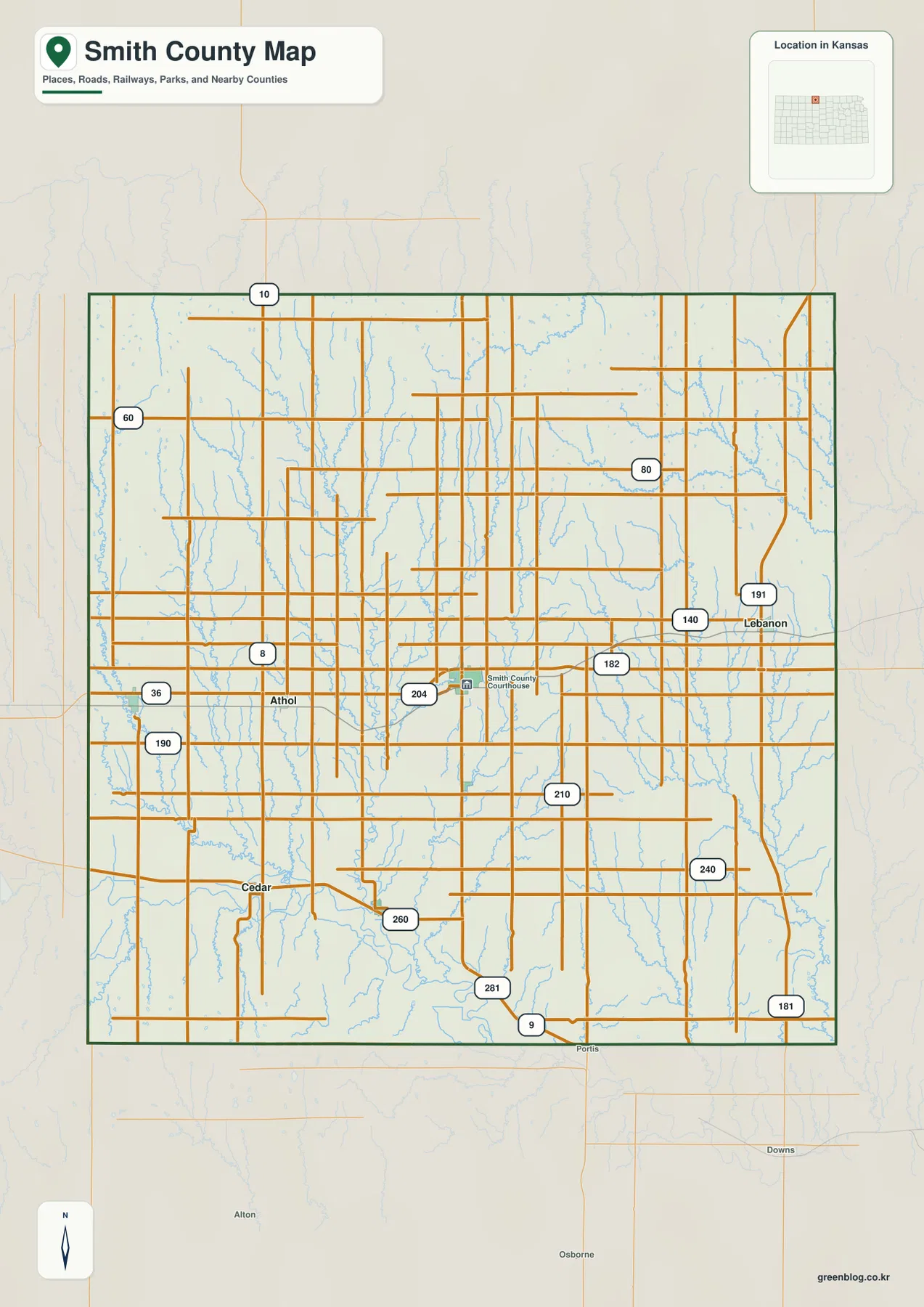
Kensington and Athol lie west of Smith Center, while Lebanon marks the eastern side of the county. Gaylord and Cedar sit farther south near the North Fork Solomon River drainage. The spacing between towns is wide enough that roads, streams, and township-scale landmarks remain important for orientation.
Smith Center leads the ranked city distribution
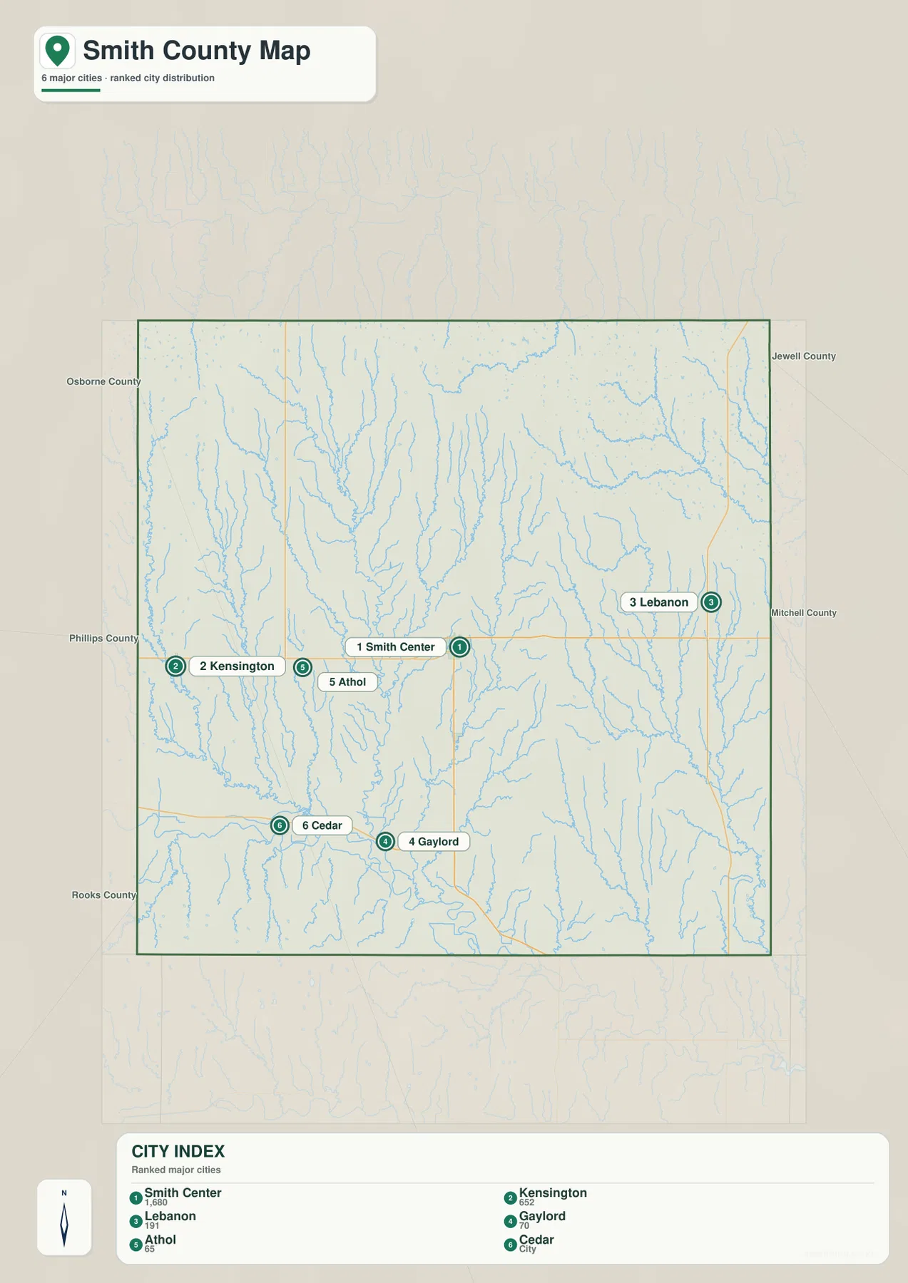
The supplied city panel lists Smith Center at 1,680, Kensington at 652, Lebanon at 191, Gaylord at 70, and Athol at 65, with Cedar included as the sixth ranked community. These values are map indices rather than current official population estimates and should not be presented as census counts.
The settlement pattern is scattered rather than linear. Smith Center occupies the middle, Kensington and Athol form western references, Lebanon is separated on the east, and Gaylord and Cedar sit closer to the southern river country. The arrangement makes the county’s rural scale immediately visible.
Kansas Historical Society census material also identifies Smith Center as the county’s largest community. The census figures and supplied map index are different datasets, but both reflect the same broad hierarchy of one main county-seat town surrounded by much smaller communities.
The North Fork Solomon River forms the county’s broad southern lowland
The strongest water feature on the terrain map is the North Fork Solomon River across the south. The river enters from the west and bends eastward through a broad, low corridor that contrasts sharply with the more dissected uplands farther north.
West Beaver Creek and Middle Beaver Creek descend from the northern and northwestern uplands, cutting long valleys toward the Solomon system. East Cedar Creek and other western tributaries create additional breaks in the high ground, while Spring Creek forms another major north–south valley through the central county.
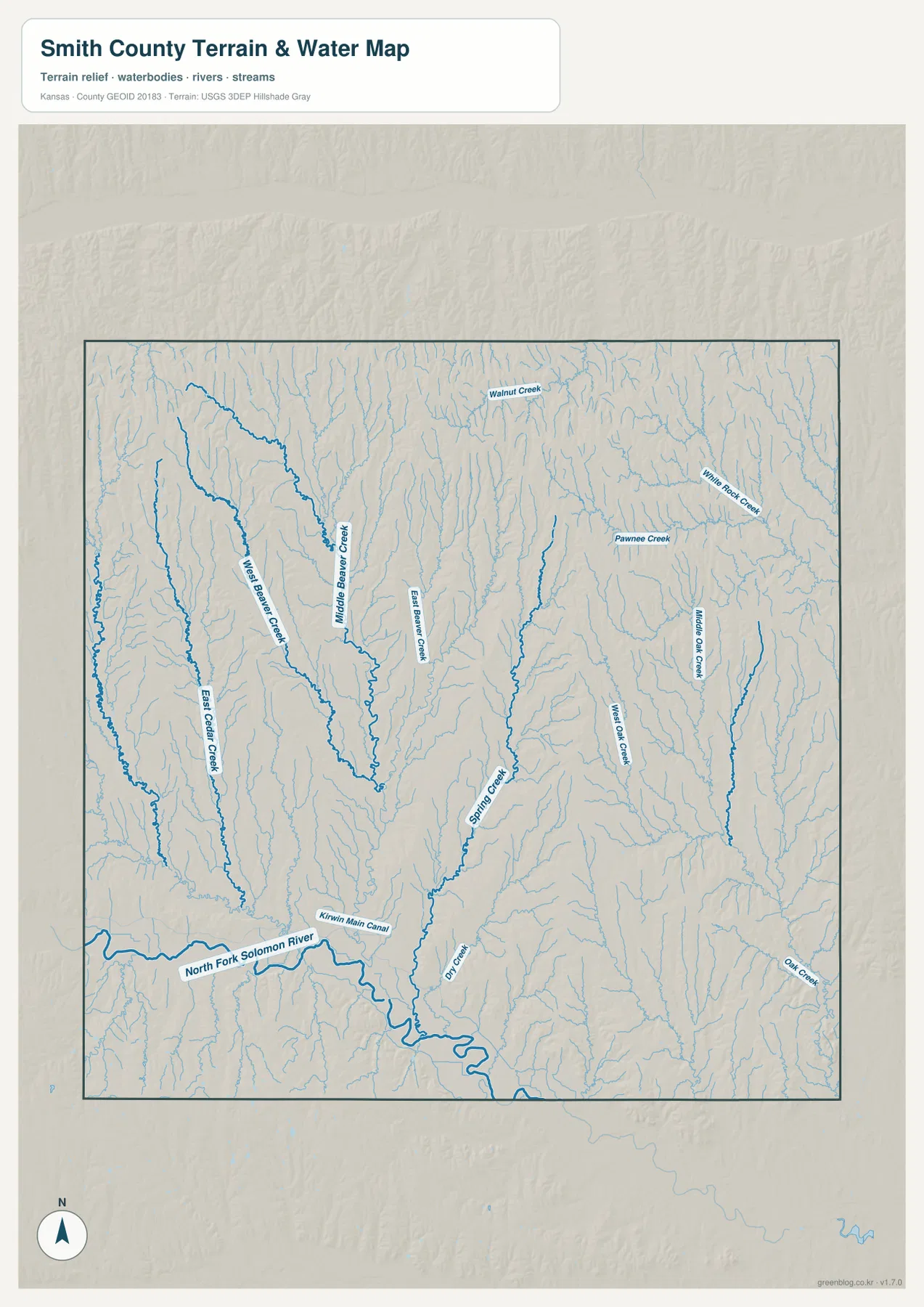
The eastern half contains West Oak Creek, Middle Oak Creek, White Rock Creek, and Pawnee Creek, while Walnut Creek crosses the northern terrain. The Kirwin Main Canal is also marked near the North Fork Solomon River in the southwest, adding an agricultural water-management feature to the natural drainage network.
This image is intended for geographic reference rather than floodplain, navigation, water-quality, irrigation-rights, parcel, or legal-boundary decisions. Stream conditions and access can change, so current agency information should be used whenever safety or property decisions are involved.
Elevation from 457 to 665 meters drops strongly toward the Solomon valley
The elevation surface ranges from about 457 to 665 meters, with a mean near 556 meters. The north and northwest contain extensive brown and tan uplands, while the North Fork Solomon River appears as a broad green lowland across the south. More than 200 meters of relief separates the county’s highest uplands from its lowest valley terrain.
West Beaver Creek, Middle Beaver Creek, White Rock Creek, and other tributaries cut narrow green corridors southward through the higher terrain. As these streams approach the Solomon valley, low ground widens and becomes more continuous.
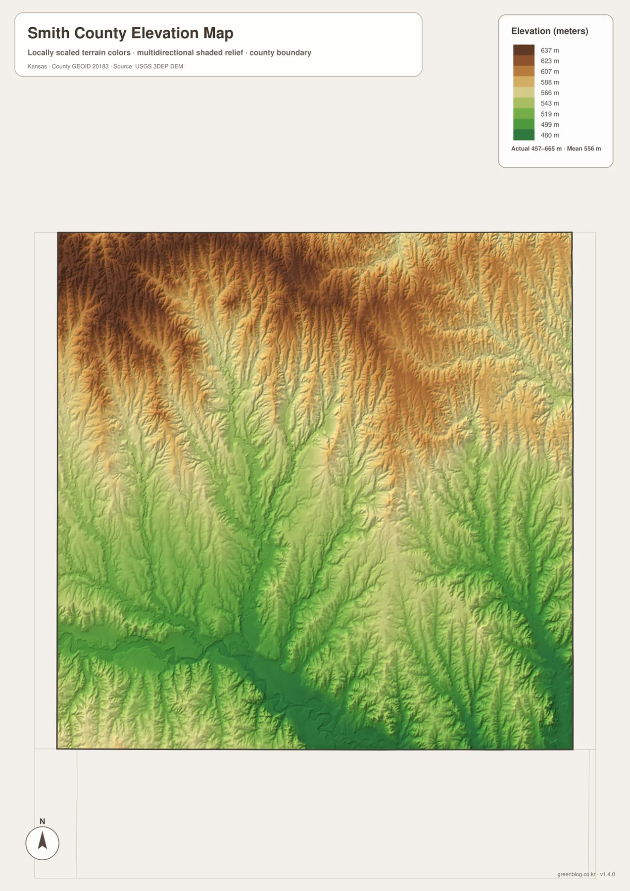
Smith Center occupies intermediate terrain rather than the deepest river lowland. Lebanon sits among heavily dissected eastern hills, while Gaylord and Cedar are closer to the broad lower valley in the south. The change is easy to miss on the road map but very clear on the relief image.
The elevation surface is generalized for county-scale comparison. It is not survey-grade or engineering-grade measurement and should not be used for parcel elevations, construction grades, drainage design, or legal boundary work.
Near Lebanon is the geographic center of the contiguous 48 states
The U.S. Geological Survey places the geographic center of the conterminous 48 states near Lebanon in Smith County, at approximately 39°50′ N and 98°35′ W. USGS also notes that no government agency has established an officially monumented center point; the well-known Lebanon monument was created locally after residents hired engineers to mark a commemorative location.
That distinction makes Lebanon unusually recognizable for such a small Kansas town. On the county map, Lebanon sits east of Smith Center among a dense network of rural roads and creek valleys. Its geographic-center association gives the eastern side of Smith County a national point of interest that is independent of city size.
The Home on the Range story began along West Beaver Creek
The Kansas Historical Society records that Dr. Brewster Higley moved to Smith County in 1871 and later lived in a small cabin along West Beaver Creek. Inspired by his surroundings, he wrote the poem “My Western Home,” which eventually became the song “Home on the Range.” Kansas adopted the song as its official state song in 1947.
The music is also tied to Smith County. Daniel Kelley, who lived in Gaylord, is credited with developing an early melody for Higley’s words. The Home on the Range Cabin and the West Beaver Creek landscape therefore connect the county’s physical geography with one of Kansas’s best-known cultural symbols.
South of Smith Center, the land falls toward Gaylord, Cedar, and the Solomon River
Traveling south from Smith Center on US 281 and local roads moves from central uplands toward the broad North Fork Solomon River lowland. Around Gaylord and Cedar, tributary valleys widen as they approach the main river, and the elevation map shows increasingly continuous green terrain.
Heading north or northwest from Smith Center produces the opposite pattern. Higher ground becomes more extensive and creek valleys cut deeper, narrower channels into the uplands. Comparing the road, water, and elevation views together explains why travel across the county can feel different even when the road grid remains fairly regular.
For posters, classroom prints, or presentation slides, use the original JPG files in the download archive rather than enlarging the web previews. Small road labels, creek names, community text, and the elevation legend remain clearer at the higher resolution.
Frequently Asked Questions
Why is Lebanon associated with the geographic center of the United States?
USGS places the geographic center of the contiguous 48 states near Lebanon in Smith County. The agency also explains that no government body established an officially monumented center; the familiar local monument is a commemorative marker created by residents.
How is Home on the Range connected to Smith County?
Brewster Higley wrote the poem that became “Home on the Range” after settling in Smith County near West Beaver Creek. Daniel Kelley of Gaylord is credited with an early musical setting, and Kansas later adopted the song as its official state song.
Can the 457–665 meter elevation image be used for surveying?
No. It is a generalized county-scale terrain image for comparing high northern uplands with the lower North Fork Solomon River valley. Parcel elevations, engineering grades, drainage design, and legal boundary work require more precise official data and, where needed, professional surveying.
Map File Information
The archive contains the Smith County, Kansas general county map, city map, terrain-and-water map, and elevation map as original high-resolution JPG files.
- Included Files: Use only the versions confirmed in the article and supplied images
- File Type: Use the confirmed download contents
- Intended Use: Printing, education, presentations, and map-based projects
Related Maps
Sources and references
- Kansas Historical Society: Smith County, Kansas — county-seat history, regional background, and Lebanon geographic-center context
- Kansas Historical Society: Home on the Range — Brewster Higley, West Beaver Creek, Gaylord, and the origin of the Kansas state song
- U.S. Geological Survey: Geographic Centers — geographic center of the conterminous 48 states near Lebanon
- U.S. Census Bureau TIGER/Line Shapefiles — county boundary and geographic reference data
- USGS National Hydrography — river and stream reference data
- USGS 3D Elevation Program — elevation and terrain reference data
Green Map creates custom-edited map images using open geographic data sources such as geoBoundaries, Natural Earth, OpenStreetMap, and government open data. These maps are edited visual materials, not raw data files, and are provided for education, documents, presentations, and graphic reference.