You can download four high-resolution JPG maps of Mellette County in one ZIP file from this page. The article starts with White River near the middle of the county and Wood farther east, then follows the road network, the White River and Little White River systems, Cottonwood Creek, White Thunder Creek, and the county’s pronounced elevation differences. The elevation legend gives an actual range of about 496 to 860 meters, and the maps show a clear contrast between higher ground in the southwest and west interior and lower creek valleys along the north and east.
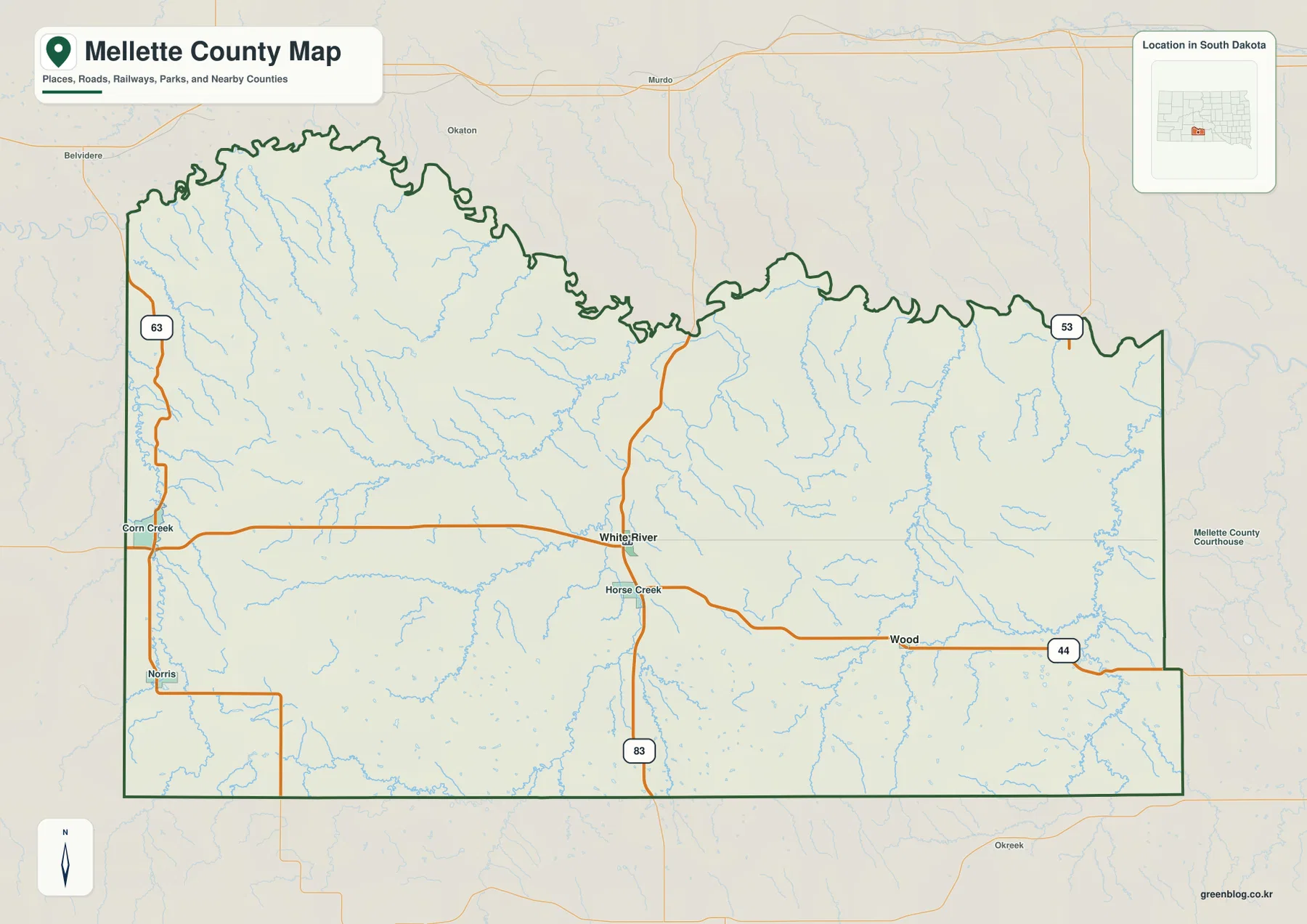
The county outline itself is useful for orientation. The southern and eastern edges are comparatively straight, while the northern side has a much more irregular shape. White River sits close to the center of the road network, Wood lies east along the 44 corridor, Corn Creek is on the west, and Norris is farther southwest. Horse Creek is labeled just south of White River, giving another reference point for following the main roads through the interior.
The map also makes it clear that Mellette County is not simply a flat road grid. Short blue tributaries cover much of the county, particularly along the northern edge and through the eastern half. Road 63 follows the west side, 83 runs south from the White River area, 44 crosses the eastern interior near Wood, and 53 appears at the northeast edge. Comparing those roads with the stream network is the quickest way to understand how towns, valleys, and higher prairie ground fit together.
Table of Contents
Use White River as the anchor for roads and place names
White River is the most practical starting point on the general county map. It lies near several road intersections and is close to the north-south route labeled 83. An east-west road extends from the Corn Creek side through White River and continues toward Horse Creek and Wood. Once White River is located, the western and eastern halves of the county are much easier to compare without relying on the county boundary alone.
On the west, road 63 runs close to the county edge and passes the Corn Creek area before continuing south toward Norris. The northeast has a 53 label near the boundary, while the east-central road labeled 44 runs through the Wood area. These are static map references rather than live road conditions. Construction, closures, surface conditions, and travel times need a current transportation source.
The numerous blue tributaries are nearly as important as the roads. Many short channels descend toward larger creeks, and the eastern half contains especially dense drainage lines. The terrain-and-water map adds names to several of those features, making it possible to connect the general road map with White River, Cottonwood Creek, Little White River, White Thunder Creek, and Oak Creek.
The city map shows White River and Wood without mileage connectors
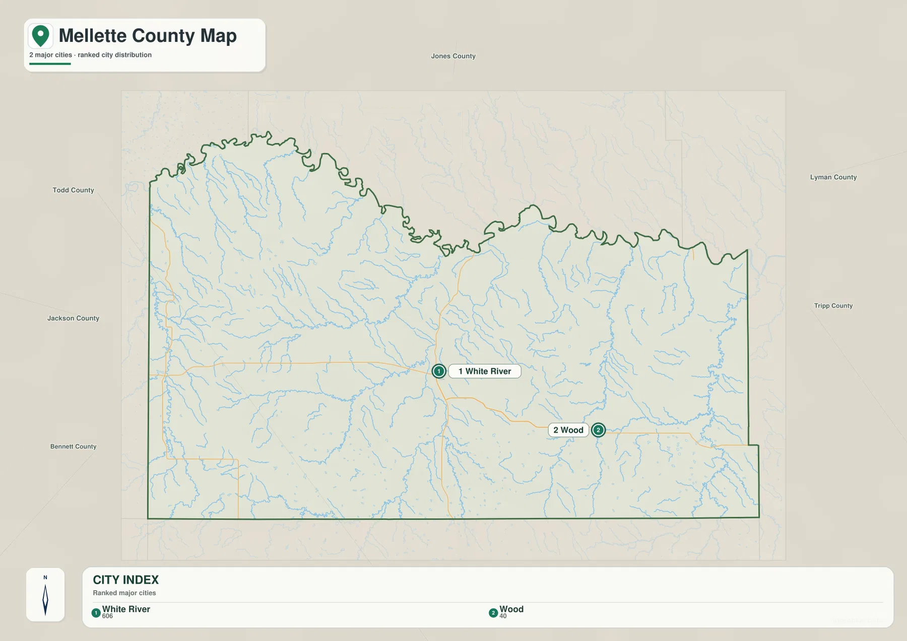
The city-distribution map emphasizes only two places: White River and Wood. White River occupies the more central position, while Wood lies to the east. The general map shows a road corridor between the two areas, but the city map does not draw a connector line and does not print a mileage value. The visual spacing should therefore be read as relative position, not as a measured straight-line or driving distance.
The CITY INDEX numbers are locator numbers for the two labels. They are not mileage, elevation, or a ranking of importance. What the map reliably tells the reader is simple: White River is the central reference and Wood is the eastern reference. For an actual road distance, travel time, or direct measurement, a separate routing or distance source is required.
Those two place names are useful anchors on the other maps as well. White River is near a part of the county where several central and northern drainages can be compared, while Wood sits closer to the eastern network associated with White Thunder Creek, Oak Creek, and their tributaries. Checking the same two areas on the elevation map also shows that the surrounding terrain is not uniform.
White River and Little White River belong to different parts of the county
The terrain-and-water map contains two similar river names that should be kept separate. White River is labeled along the northwestern edge, where it follows a winding course near the county boundary. Little White River is farther south and runs through the south-central interior. Their names are related, but the supplied map clearly places them in different parts of the county.
Between those river areas, Cottonwood Creek crosses the central part of the county and bends north. Pine Creek and Dry Creek are labeled farther south near the Little White River system. East of the center, White Thunder Creek forms a long north-south drainage and Butler Creek joins nearby. Oak Creek is labeled farther east, while Kicker Creek appears to the northeast. Together these named creeks explain the dense blue network that is already visible on the general map.
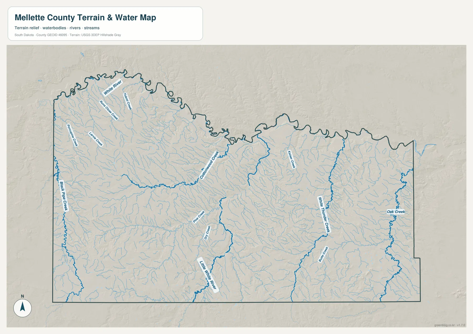
This water layer is a geographic reference for stream names and locations. It does not show real-time flow, water depth, water quality, flood zones, or navigability. A blue stream line also should not be treated as a parcel boundary or a legal property line. For current source geometry and official hydrography, consult a dataset such as USGS National Hydrography.
Elevation spans about 496–860 m, with the strongest high ground in the southwest
The elevation legend reports an actual range of approximately 496 to 860 meters and a mean near 681 meters. The southwest and much of the western interior contain broad tan and brown areas, marking the higher side of the county. The northern margin and many eastern drainage corridors are greener and lower. The difference between the listed minimum and maximum is about 364 meters, a substantial amount of relief at county scale.
The middle of the county is more varied than either extreme. Low corridors associated with Cottonwood Creek and the Little White River cut through higher ridges and rolling ground. Farther east, White Thunder Creek, Oak Creek, and smaller tributaries follow long green valleys separated by higher interfluves. The water and elevation maps line up well: the most continuous low areas generally follow the larger stream corridors.
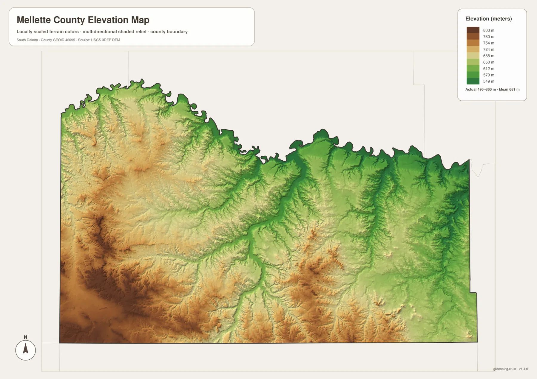
The elevation colors are intended for county-scale comparison. They are not survey measurements for a road point, house site, field corner, or engineering location. If a precise elevation is required, use an official DEM source such as the USGS 3D Elevation Program or an appropriate site survey.
Compare White River and Wood across the four map layers
White River works well as a western-central comparison point. On the general map it is a road junction and place-name anchor. On the water map it sits near the part of the county influenced by the winding northern White River and several central tributaries. On the elevation map, low creek corridors and higher nearby ridges appear together. That combination shows why a single elevation description cannot capture the whole White River area.
Wood provides a useful eastern comparison. It can be found along the 44 road corridor on the general map, and the eastern water layer contains numerous tributaries associated with White Thunder Creek and Oak Creek. The east is generally lower than the high southwestern interior, but it still contains ridges between the valleys. Looking at the same location on the road, water, and elevation maps gives a much clearer picture than treating each layer as a separate list of features.
The WebP images in the article are sized for convenient screen viewing. The download archive contains the corresponding original JPG files for the general county map, city-distribution map, terrain-and-water map, and elevation map. Each JPG is 3638 × 2572 pixels, making the originals more suitable for A3 printing, presentations, classroom materials, or closer label inspection.
Frequently Asked Questions
Does the city map give a mileage between White River and Wood?
No. The city-distribution map shows the relative locations of White River and Wood but includes no connector line and no mileage label. Use a separate routing or distance source when an actual measurement is needed.
Are White River and Little White River the same river on this map?
No. The supplied terrain-and-water map labels White River near the northwestern edge and Little White River in the south-central part of the county. They should be treated as separate mapped features.
Can the 496–860 m elevation range be used as an exact property elevation?
No. Those figures describe the county-wide elevation range, while the colored surface is meant for broad terrain comparison. Use official DEM or survey data for an exact elevation at a specific location.
Map File Information
The ZIP contains the original high-resolution JPG files for the Mellette County general map, city-distribution map, terrain and water map, and elevation map.
- Included Files: 4 JPG maps
- Printable Size: 3638 × 2572 px each
Related Maps
Sources and references
- U.S. Census Bureau TIGER/Line Shapefiles – official geographic source for county boundaries and base mapping data.
- USGS National Hydrography – official source for rivers, streams, lakes, and hydrographic data.
- USGS 3D Elevation Program – official source for elevation and DEM products.
- 2020 Census PL County Name API – Census API that can be used to verify Mellette County and South Dakota identifiers.
Green Map creates custom-edited map images using open geographic data sources such as geoBoundaries, Natural Earth, OpenStreetMap, and government open data.
These maps are edited visual materials, not raw data files, and are provided for education, documents, presentations, and graphic reference.