Harrison County sits in north-central Kentucky, with Cynthiana serving as the main road and settlement center and Berry marking the northern part of the county. U.S. 27 runs through Cynthiana, while KY 36, KY 62, and KY 32 spread into the surrounding countryside. The maps on this page compare those roads with named waterways and elevation, and the original high-resolution JPG files can be downloaded together in one ZIP. High-resolution map files are available for download in the section below.
The county becomes easier to follow once two features are fixed in mind: Cynthiana and the South Fork Licking River. The city occupies the south-central part of the county, while the river bends through lower ground nearby and continues among a dense network of tributary valleys. Higher ridges are more extensive in the west and southwest, creating a noticeable contrast with the central river corridor.
Table of Contents
Cynthiana organizes the road pattern around U.S. 27
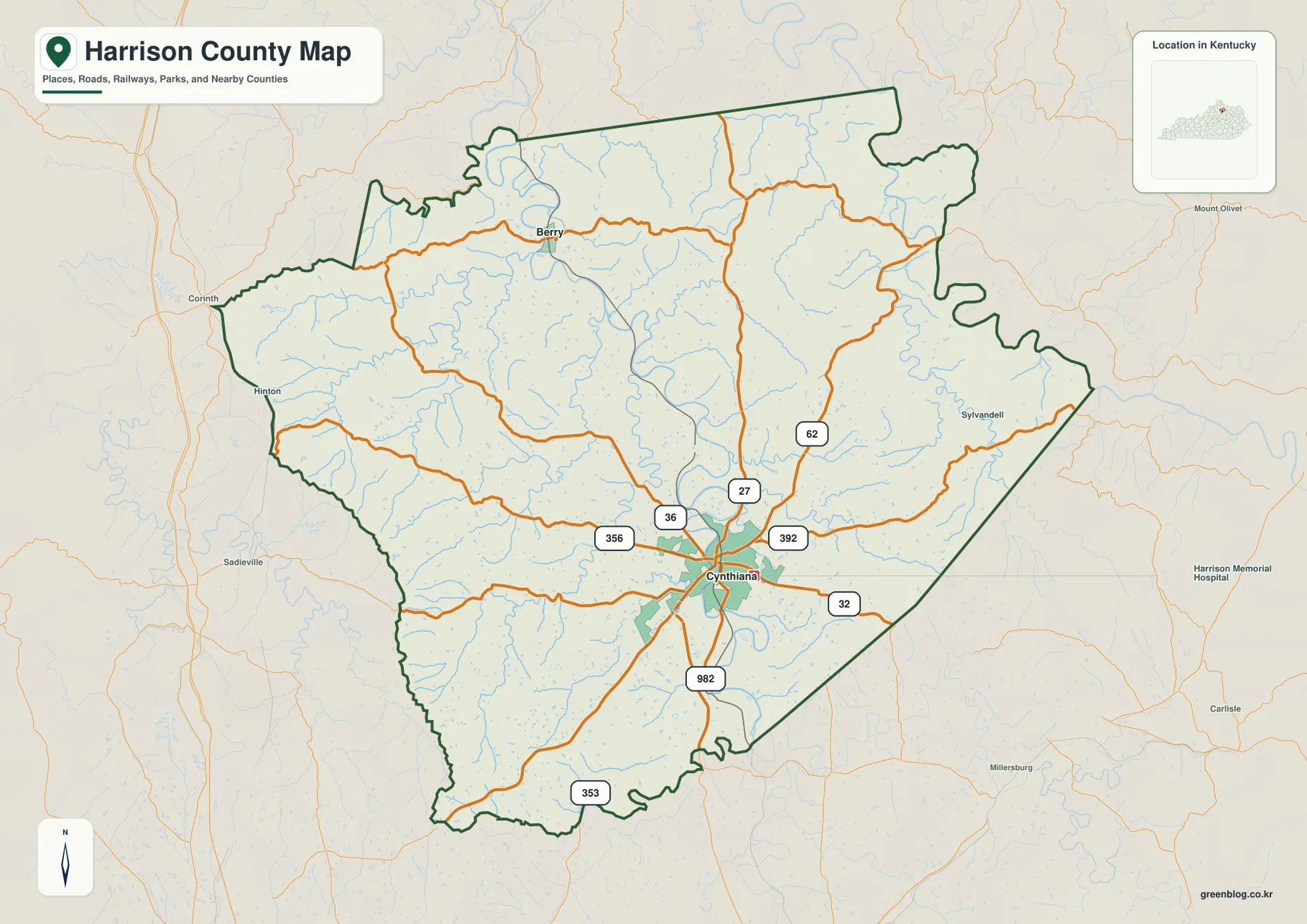
Cynthiana is the clearest place label on the county map and also the point where the major roads are easiest to separate. U.S. 27 crosses the city on a north-south course, KY 36 extends west and northeast, and KY 62 and KY 32 leave the city in different directions. Shorter routes such as KY 356, KY 392, and KY 982 fill in the rural areas between those larger corridors.
The Harrison County boundary is irregular rather than rectangular, especially along the north and east. That matters when reading roads near the edge because nearby routes and place names remain visible outside the county line. Hinton appears toward the west side, while the eastern side extends toward the Sylvandell area along KY 32. Keeping the heavy boundary line in view prevents a neighboring road or creek from being mistaken for a feature inside Harrison County.
This county map is designed for regional orientation rather than parcel research or live navigation. It works well for locating Cynthiana, Berry, the primary numbered highways, and the county outline on one page. Exact property boundaries, current closures, or turn-by-turn driving information require the appropriate official or navigation source.
Cynthiana and Berry reveal a strongly uneven city distribution
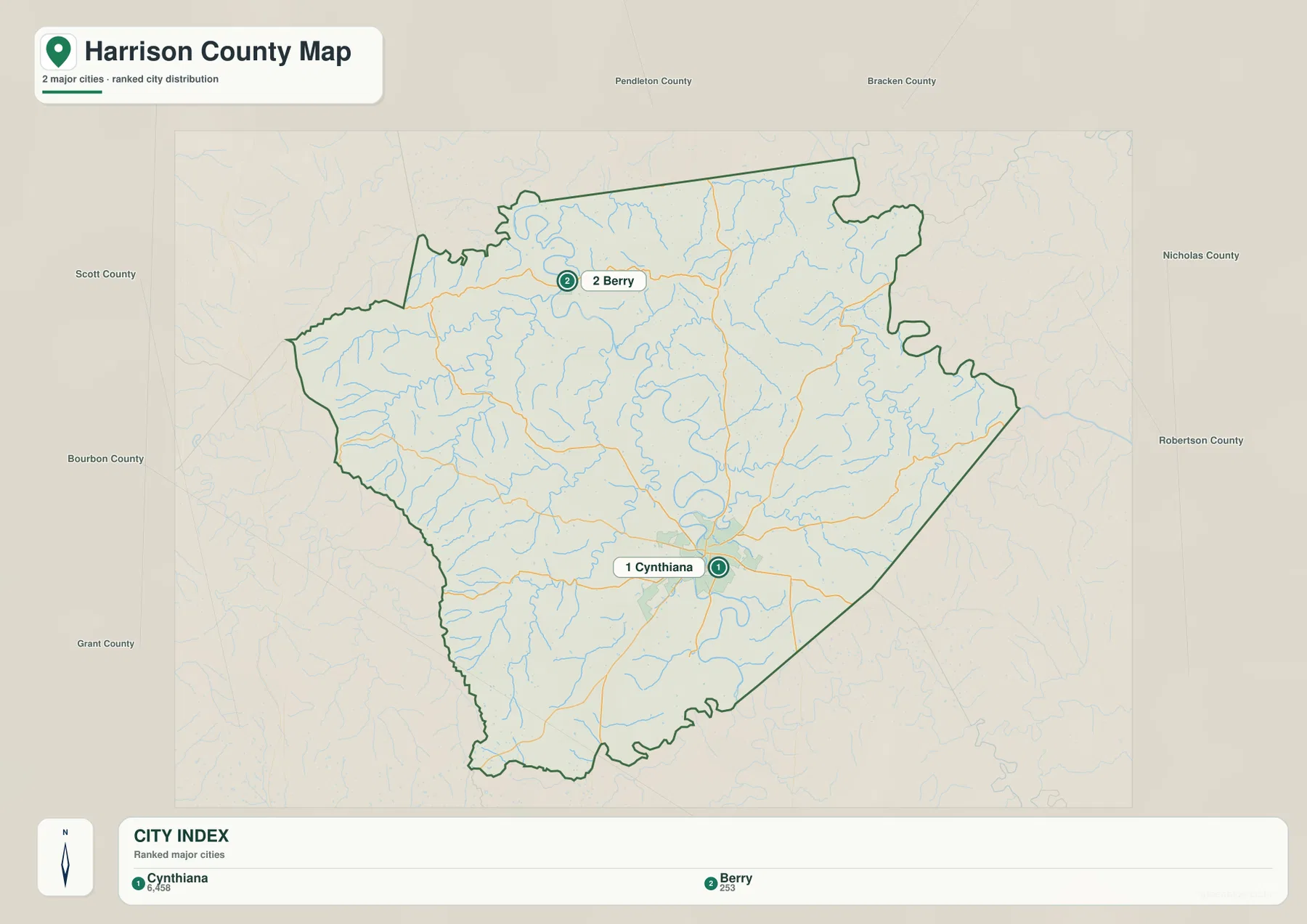
The city map ranks Cynthiana and Berry as the two principal city references in the package. Its index shows 6,458 for Cynthiana and 253 for Berry, a wide gap that reflects how strongly the county is centered on Cynthiana. Those figures are map reference values rather than a replacement for current Census estimates, so up-to-date demographic work should use the latest official population data.
The geographic contrast is just as important as the numeric one. Cynthiana sits in the south-central county where several major routes meet, while Berry occupies a much smaller northern setting among local roads and stream valleys. The county therefore does not read as a chain of similarly sized towns. A single dominant city is surrounded by a broad rural landscape, with Berry serving as a convenient northern marker.
For a presentation or classroom handout, the city view removes most road and water labels and leaves the settlement pattern clear. When a route between the two places matters, the county map adds the necessary highway detail. Switching between the two views keeps the city relationship legible without crowding every label onto the same page.
The South Fork Licking River occupies the county’s central low corridor
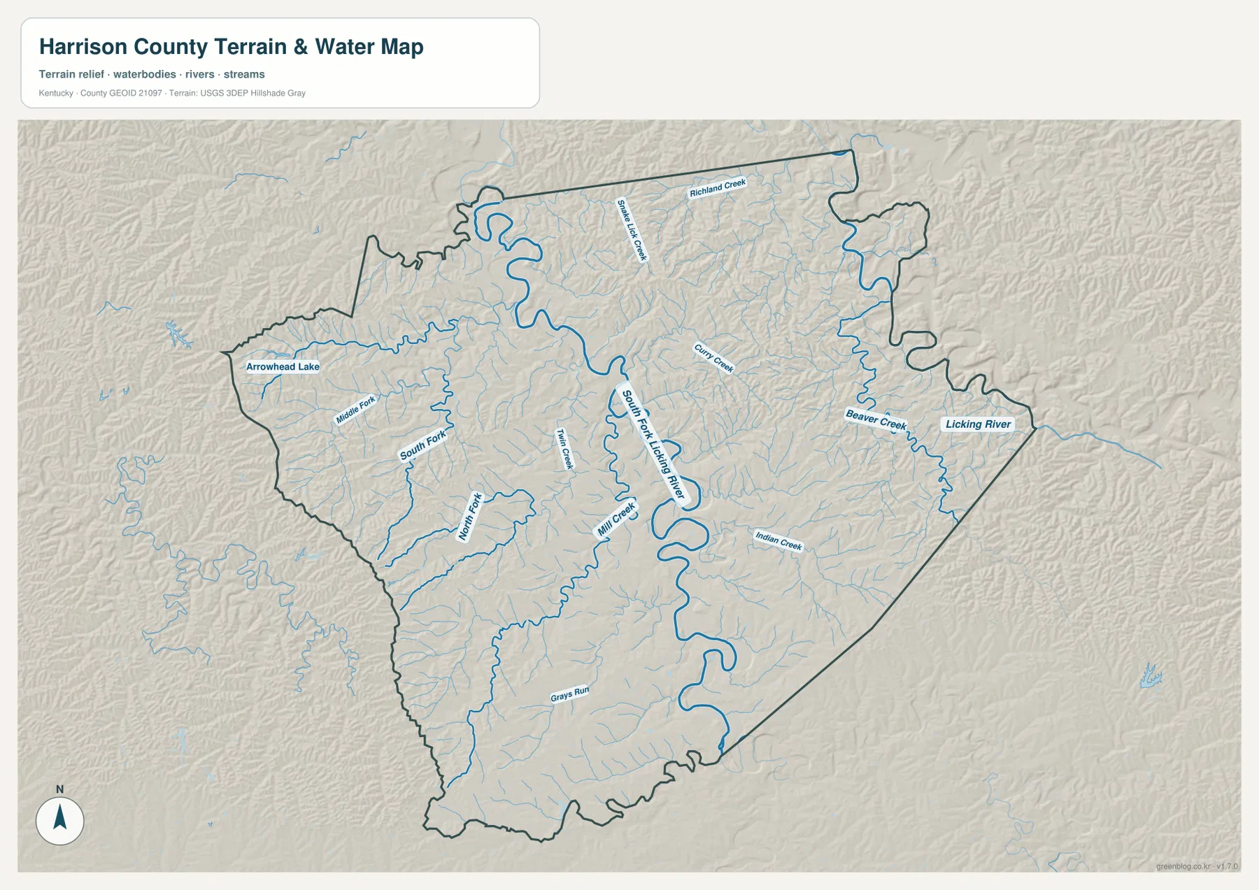
The South Fork Licking River is the strongest water feature on the terrain-and-water map. It makes broad bends through the middle of Harrison County and is joined by a large number of smaller streams. Richland Creek, Snake Lick Creek, Curry Creek, and Beaver Creek appear in the northern and eastern parts of the county, while Indian Creek, Mill Creek, Twin Creek, and Gray’s Run occupy other branches of the network.
On the western side, Middle Fork and South Fork labels identify additional parts of the Licking River system. Arrowhead Lake provides a separate small-water landmark in the northwest. These names are valuable when two rural roads look similar because a nearby creek often distinguishes one valley from another more clearly than the road pattern alone.
Cynthiana-Harrison County Tourism describes paddling and fishing opportunities on the local Licking River forks, connecting the mapped waterways with recreation in the county. The map itself remains a static geographic reference: it does not report current river stage, flood insurance zones, water quality, navigation conditions, or land ownership. Those questions require current agency information.
Elevation rises from river bottoms toward broad western and southwestern ridges
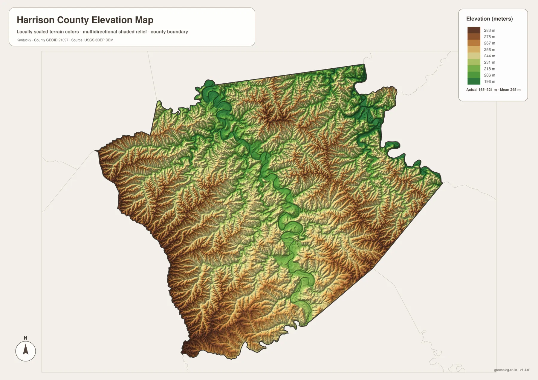
The elevation map records an actual range of about 165 to 321 meters and a mean of 245 meters. Lower colors follow the South Fork Licking River and several tributary valleys through the central county. Narrow low corridors also appear farther north and east where smaller streams have cut into the rolling ground.
Higher terrain is more extensive across the west and southwest. Elevated ridges also repeat along parts of the southern boundary, while the east contains shorter steep sections separated by narrow valleys. Harrison County is not mountainous, but the frequent shift from creek bottom to ridge produces repeated changes in slope over short distances.
The road map reflects that terrain. U.S. 27 maintains a relatively direct county-wide course, whereas many smaller rural roads bend along valleys or cross between ridges. The elevation colors describe relative county-scale height; they are not survey measurements for a parcel, building, drainage design, or construction project.
Roads and creeks together make rural locations easier to distinguish
A rural location in Harrison County is often easier to identify by combining a road with a creek than by using either feature alone. North of Cynthiana, U.S. 27 leads toward Berry, and nearby stream names separate one valley from the next. East or west of the city, KY 36, KY 62, and KY 32 can be checked against the bends of the South Fork Licking River or against named tributaries.
The western countryside contains fewer large place labels, so terrain becomes a stronger clue. A creek on the water map can be matched with a lower strip on the elevation map, while the adjoining brown or tan areas mark higher ridges. This comparison is particularly effective where several local roads curve through similar-looking farmland and one stream name is the clearest distinguishing feature.
Berry works the same way for the northern county. Once the city is located, nearby roads, creeks, and the irregular county boundary can be matched across the map set. This approach keeps the county readable without treating every small road label as equally important.
Match the map file to the detail you need to print or compare
The county map combines boundaries, Cynthiana, Berry, U.S. 27, state highways, and surrounding place labels. The city map removes most of that detail and concentrates on the two ranked city locations. The terrain-and-water map carries the densest collection of stream names, while the elevation map separates lower valleys from higher rolling ground through the 165–321 meter range.
The download archive contains the original high-resolution JPG versions of the county map, city map, terrain-and-water map, and elevation map. These larger files are better suited to enlarging small labels or preparing an A3 print than the WebP previews embedded on the page. All four use the same Harrison County extent, so they can be compared side by side without reconciling different boundaries.
Frequently Asked Questions
Which city is the clearest first reference point in Harrison County?
Cynthiana is the clearest starting point because it sits in the south-central county where U.S. 27 and several state routes meet. Berry is the secondary city reference for the northern part of the county.
Where should I look for the South Fork Licking River and its tributaries?
The terrain-and-water map contains the most detailed stream labeling. It shows the South Fork Licking River together with Richland Creek, Snake Lick Creek, Beaver Creek, Indian Creek, Mill Creek, and other tributaries. The elevation map can then be used to compare those stream valleys with the higher ridges beside them.
Is the 165–321 meter elevation map suitable for surveying?
No. The map summarizes county-wide relief with a mean elevation of 245 meters and is intended for comparing valleys and ridges. Exact property elevations, engineering design, and legal surveying require detailed source data or a qualified survey.
Map File Information
The ZIP contains the original high-resolution JPG files for the four Harrison County maps described on this page.
- Included Files: county map, city map, terrain and water map, and elevation map
Related Maps
Sources and references
Local recreation and Licking River context are available from Cynthiana-Harrison County Tourism and its recreation guide. County boundary and road references can be checked through the U.S. Census Bureau TIGER/Line program and Kentucky Transportation Cabinet maps.
Water-feature reference data are available through USGS National Hydrography, and elevation source information is available through the USGS 3D Elevation Program. The maps on this page are county-scale geographic references rather than live traffic, flood, parcel, or survey products.
Green Map creates custom-edited map images using open geographic data sources such as geoBoundaries, Natural Earth, OpenStreetMap, and government open data. These maps are edited visual materials, not raw data files, and are provided for education, documents, presentations, and graphic reference.