Knox County occupies a varied part of northeastern Nebraska where the Missouri River forms the northern edge and the Niobrara River reaches the Missouri near the village of Niobrara. Creighton, Bloomfield, Crofton, Wausa, Verdigre, and Niobrara are spread across broad agricultural uplands and deeply cut stream valleys, while Center serves as the county seat. Highway 12 crosses the northern tier, Highway 84 serves the eastern interior, and Highways 13, 14, 59, and 121 connect several southern communities. This page compares settlements, roads, rivers and creeks, and an elevation range of about 368 to 589 meters. Four original high-resolution JPG maps can also be downloaded together in a ZIP file for printing or closer viewing. High-resolution map files are available for download in the section below.
Knox County is easier to understand through its rivers and relief than through a single urban center. Official county material describes a northern boundary shaped by the Missouri and a western section crossed by the Niobrara before the two rivers meet. The courthouse is in Center, even though the ranked city map places Creighton first by its printed city index. On the elevation sheet, low green river valleys contrast strongly with higher brown hill country in the east-central and southeastern parts of the county. Reading those layers together explains why roads and communities are distributed so differently from one part of Knox County to another.
Table of Contents
Highway 12 organizes the northern river towns while smaller routes serve the interior
Highway 12 provides the simplest first reference across northern Knox County. It runs from the Niobrara area eastward through the Lindy corridor and toward Crofton, keeping much of the route relatively close to the northern river country. Niobrara lies near the meeting of the Niobrara and Missouri rivers, while Santee is farther northeast near the Missouri. Verdel sits near the northwestern side of the county and helps orient the border toward Boyd and Holt counties.
The middle and south rely on a different set of roads. Bloomfield occupies the east-central interior along Highway 84, and Wausa lies farther southeast near Highway 121. Creighton is in the southern interior near Highways 13 and 59, while Verdigre is farther west along Highway 14. Center lies between the Verdigre and Bloomfield sides of the county and functions as the government center. The road pattern therefore works more like a web of smaller regional routes than a single dominant highway spine.
Smaller place names such as Bazile Mills, Santee, Lindy, and Magnet add useful rural reference points. Bazile Mills lies north of the Creighton area, while Magnet is near the southeastern edge beyond Wausa. These places do not appear in the ranked six-city map, but they matter when reading the road and stream network. The general county sheet is therefore the better choice when the task is locating a small community, a highway, or the county boundary rather than comparing settlement size.
Six ranked communities show how settlement is spread across the county
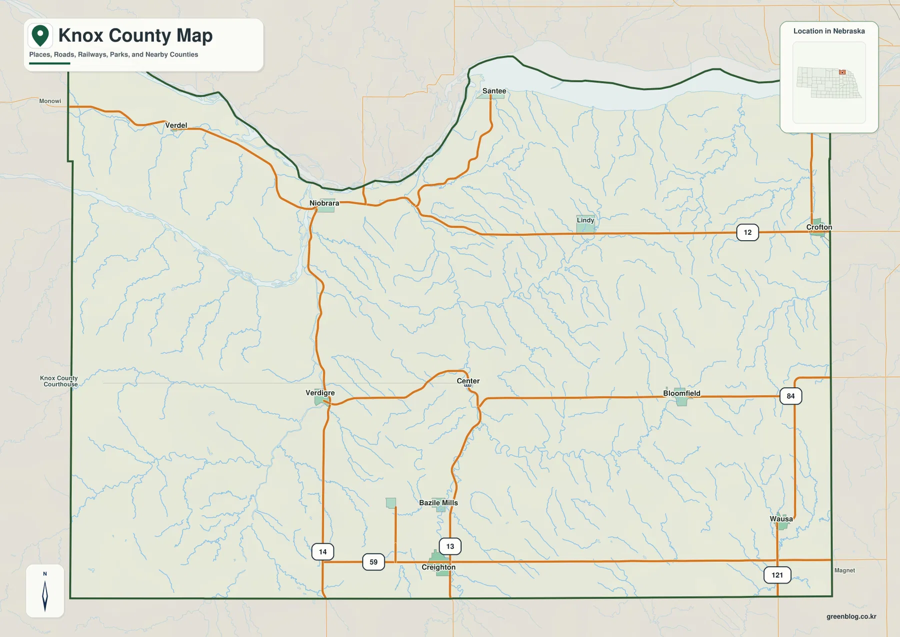
The city-distribution map ranks six major communities. Creighton is first, followed by Bloomfield, Crofton, Wausa, Verdigre, and Niobrara. The graphic prints index values of 1,222 for Creighton, 959 for Bloomfield, 902 for Crofton, 698 for Wausa, 613 for Verdigre, and 353 for Niobrara. Those values belong to the supplied map and should be treated as a map index rather than a live population table; current demographic questions are better checked against recent Census data.
The geography of the six places matters as much as their ranking. Creighton is in the southern interior, Bloomfield is east-central, Crofton is in the northeast, Wausa is in the southeast, Verdigre is in the southwest, and Niobrara is near the northwestern river junction. The pattern spreads major communities around the county rather than concentrating them in one corridor. A different town therefore becomes the most useful reference depending on whether the reader is looking at the Missouri side, the southern farm country, or the western Niobrara drainage.
Center is absent from the ranked six-city list, but that does not reduce its administrative importance. Knox County’s official website places the courthouse in Center, where county offices operate today. The distinction is useful: the city-distribution map is showing relative settlement size, while county government functions are centered in a smaller community. Creighton can rank first on one map while Center remains the county seat.
The Niobrara–Missouri confluence defines the northwestern corner
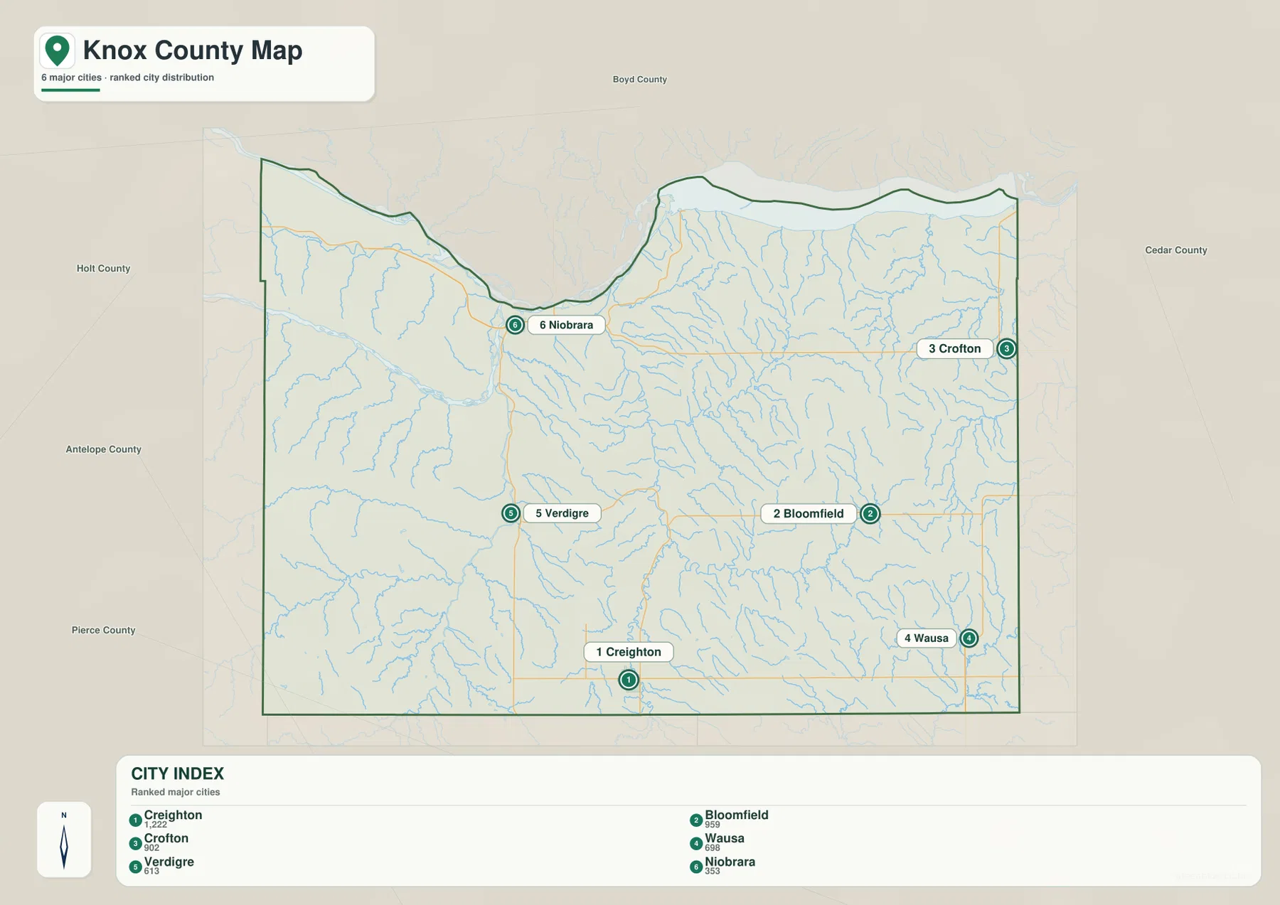
The two strongest water features are the Missouri River and Niobrara River. The Missouri forms the northern edge of Knox County, while the Niobrara enters from the west, curves toward the village of Niobrara, and joins the Missouri. Nebraska Game and Parks describes Niobrara State Park as being situated at that confluence. The meeting of two large rivers creates one of the county’s most distinctive natural settings and provides an easy landmark for the entire northwest.
South and west of the Niobrara are smaller streams including Ponca Creek and Painter Creek. The Verdigre area contains North Branch Verdigre Creek and Middle Branch Verdigre Creek, which descend through the western uplands toward larger drainage corridors. On the elevation map, the same streams occupy narrow green valleys between tan and brown ridges, so the water and relief layers reinforce one another.
The Missouri boundary is also strongly shaped by terrain. The county line bends with the river, and broad low ground lies below steeply dissected bluffs. Nebraska’s Wild and Scenic River documentation treats the lower Niobrara and an adjoining Missouri reach in Knox County as nationally important river segments. Even without that designation, the map itself makes the contrast clear: the river floors are some of the lowest parts of the county, and the land rises rapidly southward.
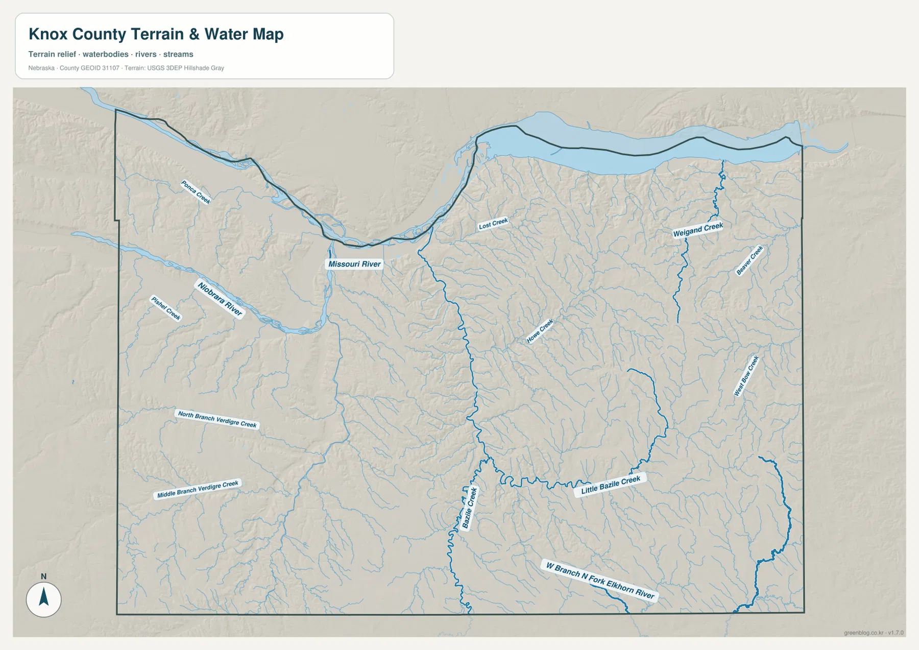
This is a general water-reference map rather than a flood, navigation, parcel, or real-time river product. Current water levels, access, boat ramps, and flood conditions can change. Visitors heading to Niobrara State Park or other river sites should check current information from Nebraska Game and Parks or the relevant agency. For regional map reading, the main purpose is to show how the two large rivers and many tributaries organize the county.
Bazile Creek and eastern tributaries dissect the higher hill country
Bazile Creek is one of the most prominent interior streams on the water map. It runs generally northward through the central part of the county, while Little Bazile Creek approaches from the east. Together they form a useful natural reference between the Bloomfield and Creighton sides of the county. The valleys are narrower and more winding than the broad Missouri floodplain, which makes the interior terrain feel much more broken.
The northeast includes Weigand Creek and Beaver Creek, while Home Creek lies farther toward the center-east. In the southeast, the West Branch North Fork Elkhorn River reaches toward the county boundary. These waterways do not all drain toward the same immediate river, which is why Knox County’s internal drainage pattern is more complex than the two large northern rivers alone would suggest.
The hill country around those eastern streams is especially clear on shaded relief. Brown and tan ridges are repeatedly cut by narrow green valleys, creating a dense branching texture. Rather than describing eastern Knox County simply as “higher,” it is more accurate to see it as a dissected upland where local relief changes quickly between ridges and creek bottoms.
A 368–589 meter elevation range separates river bottoms from eastern uplands
The supplied elevation map gives an actual county-wide range of about 368 to 589 meters, with a mean near 488 meters. The lowest dark-green terrain follows the Missouri and Niobrara river valleys, while the highest brown and dark-tan colors are concentrated in the east-central and southeastern hill country. The roughly 221-meter difference between the mapped low and high points is substantial enough to create very different landscapes within one county.
Along the northern river edge, low green ground is bordered by steeply rising tributary slopes. The contrast is especially visible around the Niobrara confluence and along the northwestern side near Verdel. In a short horizontal distance, the map shifts from river-bottom green to yellow and brown uplands. This explains why the river corridor feels physically distinct from the broad agricultural interior.
The east-central area has the opposite character. High brown ridges cover a large block east of the county center, and Weigand Creek, Beaver Creek, Little Bazile Creek, and many unnamed tributaries cut narrow lower channels through it. Creighton and Wausa lie in somewhat more moderate southern terrain, but even there the surface is repeatedly broken by small valleys rather than being completely flat.
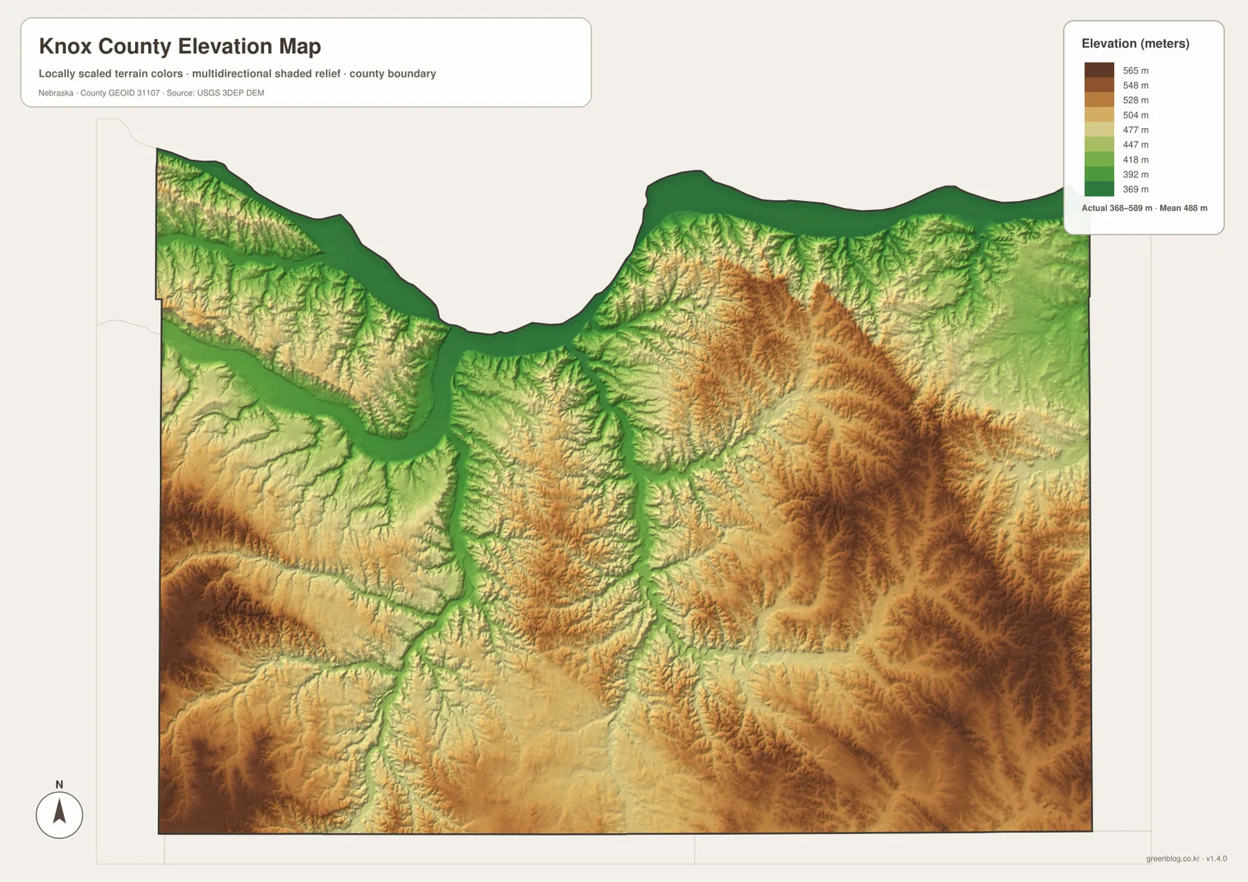
The elevation surface is generalized for county-scale comparison. It is not survey-grade information for a parcel, building site, drainage design, road grade, or engineering project. Those tasks require current detailed elevation data such as the USGS 3D Elevation Program and, where appropriate, professional measurements. For regional study, however, the map makes the river-bottom versus upland contrast immediately visible.
Niobrara State Park makes the two-river landscape easy to visualize
Niobrara State Park provides a real-world example of the northwest terrain. Nebraska Game and Parks places the park at the confluence of the Niobrara and Missouri rivers and offers hiking, camping, fishing, boating, and wildlife viewing. On the map, the park area sits beside the lowest river terrain but close to steep bluffs and tributary valleys rising to the south.
The elevation sheet shows why the park landscape is more varied than a flat riverbank. Green lowlands are squeezed against higher tan and brown slopes, and many short drainage lines cut toward the rivers. The result is a rapid change in relief around the confluence. That setting differs sharply from the higher agricultural hill country near Bloomfield and Wausa even though both are part of the same county.
The Niobrara area also carries historical importance. History Nebraska records that Niobrara once served as the county seat before government eventually moved to Center. Today the two places represent different functions on the map: Niobrara is a natural and recreational landmark at the river junction, while Center is the administrative focus in the interior. Remembering that distinction makes both the county history and the modern geography easier to understand.
Choose the map by whether the question is about communities, water, or relief
The general county map is the best first choice for Niobrara, Crofton, Bloomfield, Wausa, Creighton, Verdigre, Center, and the numbered highways. It keeps settlements, roads, county boundaries, and nearby places in one view. The city-distribution map strips away most of that background and makes the relative size and spread of the six ranked communities easier to compare.
The terrain-and-water map is more useful for the Missouri–Niobrara confluence, Bazile Creek, the Verdigre Creek branches, Weigand Creek, and other smaller streams. The elevation map answers a different question by showing where the county is high or low. Viewed together, those two sheets explain why low green valleys closely follow the major rivers and why the eastern tributary network is carved into much higher ground.
A practical study sequence is to locate the towns and highways first, trace the two major rivers and key creeks on the water map, and then compare the same locations with the elevation surface. The WebP images on the page are convenient previews, while the original JPG files are better for enlarging labels or printing. These are general-reference products, so legal boundaries, flood determinations, live road conditions, river levels, surveying, and engineering work should use the latest authoritative source for the specific task.
Frequently Asked Questions
Where is the Knox County seat?
Center is the current county seat. Creighton is the largest ranked community on the supplied city map, but the courthouse and county offices are located in Center.
Do the Niobrara and Missouri rivers meet inside Knox County?
Yes. The Niobrara reaches the Missouri near the village of Niobrara in the northwestern part of the county. Niobrara State Park is located at the confluence area.
Can the 368–589 meter elevation range be used for surveying or construction?
No. The elevation map is a generalized county-scale reference. Parcel surveys, construction, drainage design, and road engineering require current detailed elevation data and professional measurements.
Map File Information
The county, city-distribution, terrain-and-water, and elevation maps are available together in one ZIP file. It contains four original high-resolution JPG maps suitable for detailed viewing and printing.
- Included Files: County map, city-distribution map, terrain-and-water map, elevation map
- File Type: JPG files in a ZIP archive
Related Maps
Sources and references
These official and public sources provide additional context for county government, local communities, Niobrara State Park, administrative boundaries, waterways, and elevation.
- Knox County, Nebraska – About Our County – county overview and government information
- Knox County Nebraska – Live Here – community information
- Nebraska Game and Parks – Niobrara State Park – confluence-area park information
- U.S. Census Bureau TIGER/Line – administrative boundary data
- USGS National Hydrography – river and stream data
- USGS 3D Elevation Program – elevation data
Green Map creates custom-edited map images using open geographic data sources such as geoBoundaries, Natural Earth, OpenStreetMap, and government open data. These maps are edited visual materials, not raw data files, and are provided for education, documents, presentations, and graphic reference.