Owen County centers on Spencer, with Gosport in the northeastern extension, Patricksburg to the west, and Coal City near the southwest edge. You can download the high-resolution JPG ZIP directly from this page. The larger originals make it easier to read road shields, creek names, lake labels, and the county’s heavily cut relief. This Owen County Indiana Map page combines the Spencer road network with a two-place city index, White River and the Cagles Mill Lake drainage, and a 153–284 meter elevation surface dominated by valleys and short ridges.
Spencer is the best place to begin because it is the county seat and the clearest developed center. State Road 46 runs east-west through the area, State Road 43 provides an eastern reference, and U.S. 231 with State Road 67 leads south into the hillier lower county. Patricksburg sits west along State Road 246, while Coal City marks the southwest near State Road 157. Gosport lies apart in the northeastern projection of the county and provides a useful eastern reference near lower White River terrain.
The physical maps show why roads alone do not explain Owen County well. White River bends through the southern and southeastern lowlands, Rattlesnake Creek runs through the interior, and smaller valleys such as Lick Creek and Raccoon Creek cut deeply into the hills. Cagles Mill Lake and Mill Creek provide a separate northern water reference. The elevation legend reports an actual range of about 153 to 284 meters and a mean of 206 meters, with broad green lowlands along the major valleys and densely broken higher ground to the north and east.
Table of Contents
Spencer ties the east–west road line to U.S. 231 and the southern hills
Spencer has the most obvious developed footprint on the general map. State Road 46 crosses the county through the town, State Road 43 provides another eastern marker, and U.S. 231 with State Road 67 continues south through a landscape of curving roads and creek valleys. In a county with few large settlements, this road concentration makes Spencer more useful for orientation than any other town label.
West of Spencer, State Road 246 leads toward Patricksburg through a broad rural section. The county boundary steps inward on the west before widening again farther south, and the road pattern becomes more irregular as the terrain breaks into short hills and stream cuts. Coal City sits near the southwestern edge and is easiest to place with State Road 157 and the surrounding local roads.
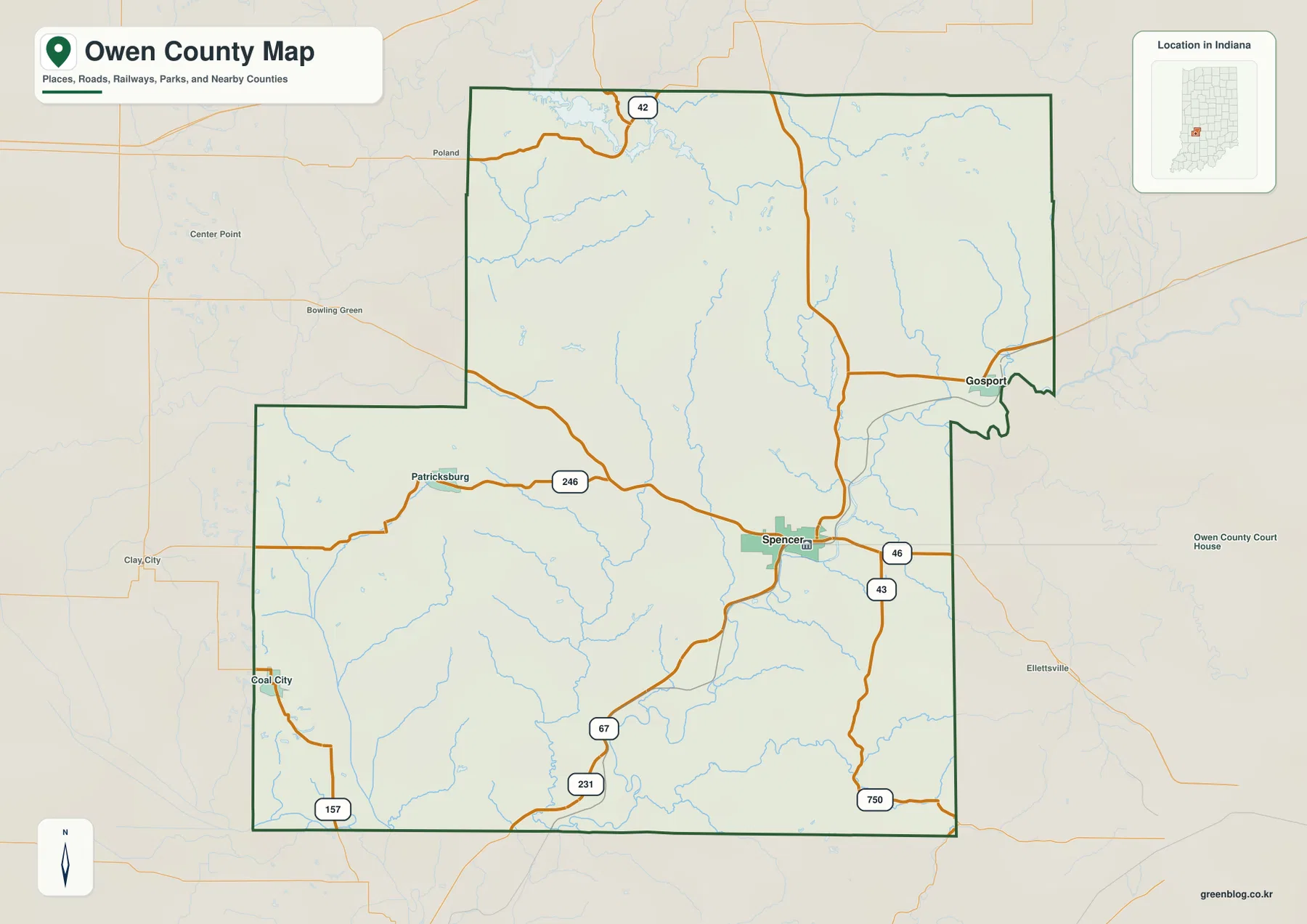
Gosport occupies the narrow northeastern part of the county. The approach from Spencer follows the larger northward road system before turning toward the east, and the town sits close to lower river terrain that becomes especially obvious on the elevation map. Its position also helps explain the irregular eastern boundary, which pushes outward around the Gosport area before returning south.
State Road 42 appears across the northern side near the Cagles Mill Lake area. Nearby places outside the county, including Poland, Center Point, and Bowling Green, provide useful surrounding references on the basemap, but the article focuses on the Owen County roads and settlements inside the green boundary. This distinction is helpful in a map where the county outline has several steps and projections rather than a simple rectangle.
The city index reduces Owen County to Spencer and Gosport
The supplied city index contains only two ranked places. Spencer is printed at 2,481 and Gosport at 1,303. These figures belong to the supplied map edition rather than a live demographic feed. The simplified view is useful because it removes the dense road and creek network and shows the county’s main population reference near the center-east and a second town in the northeastern projection.
| Rank | Place | Value printed on map | Position |
|---|---|---|---|
| 1 | Spencer | 2,481 | Center-east |
| 2 | Gosport | 1,303 | Northeast |
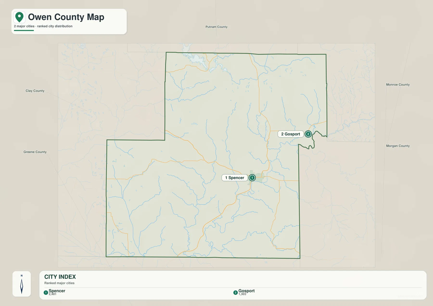
Spencer and Gosport serve different geographic roles. Spencer is the road and administrative center tied to State Road 46 and the routes leading south, while Gosport helps define the northeastern edge and the lower White River side of the county. Even with only two ranked places, the index clearly separates the central road hub from the eastern river-oriented town.
Patricksburg and Coal City appear on the general map but not in the city index. Return to the general map when those smaller settlements, county roads, or boundary details matter. Use the index only when the goal is a quick comparison of Spencer and Gosport. For current population totals, consult a current official statistical source rather than treating the printed index values as live counts.
White River shapes the south while Cagles Mill Lake anchors the north
White River is the strongest water feature in the southern and southeastern part of the terrain-and-water map. Its broad bends occupy a low corridor, with Raccoon Creek and Fish Creek joining the surrounding drainage network. The river valley also appears as one of the widest green areas on the elevation map, making it an easy feature to follow even when road labels disappear.
Rattlesnake Creek runs through the center and helps divide the interior hills into long narrow ridges. Lick Creek and Brush Creek organize the southwest, while Limestone Creek provides an eastern reference near the Gosport side. The repeated creek valleys are important because Owen County is not a place where one river alone explains the terrain; smaller channels cut the uplands into a dense pattern of hills and hollows.
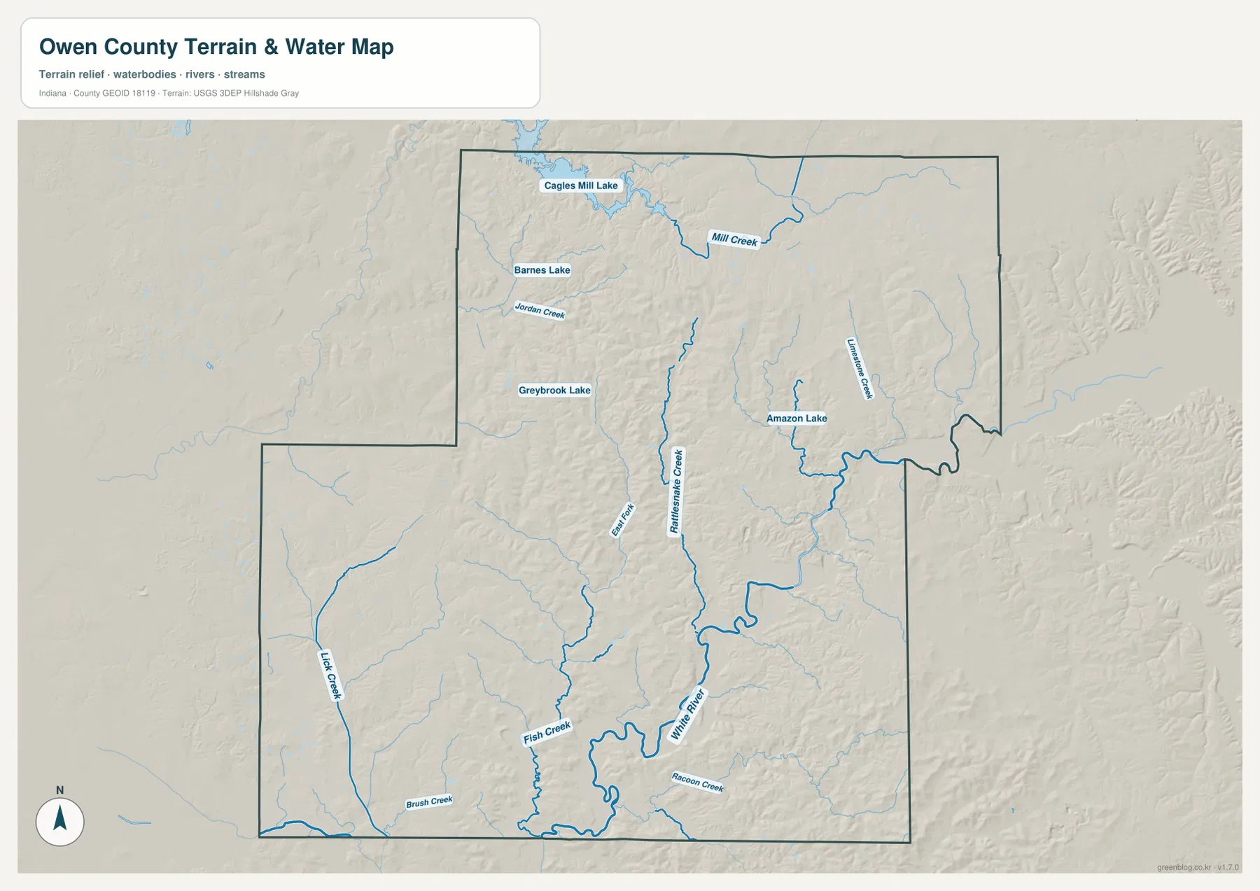
Cagles Mill Lake appears along the northern edge with Mill Creek feeding the lake area. Indiana DNR describes Cagles Mill as a 1,400-acre lake and notes that Mill Creek is part of the same system that includes Cataract Falls. On this county map, the lake works best as a northern landmark rather than a feature that dominates the whole county, and it contrasts strongly with White River in the south.
Barnes Lake and Greybrook Lake add smaller western and west-central water references, while Amazon Lake appears farther east. They are much smaller than White River or Cagles Mill Lake, but their fixed shapes help relocate creek valleys in the hillier interior. The terrain-and-water image is intended for geographic orientation; flood status, current water conditions, navigation rights, property ownership, and legal water boundaries require the appropriate current agency source.
The 153–284 m relief drops into White River lowlands and rises sharply through the north and east
The elevation legend gives an actual Owen County range of about 153 to 284 meters and a mean of 206 meters. Low terrain appears in green, while yellow, tan, and brown mark higher ground. The southwest and White River corridor contain broad low areas, while the northern and eastern county is dominated by tightly packed ridges and narrow stream-cut valleys.
The northern half is especially rugged. Around the Cagles Mill Lake and Mill Creek side, green drainage cuts push into higher tan and brown hills. Similar ridge-and-valley relief continues across the northeast, where lower terrain around the Gosport and river side contrasts with nearby high ground over short distances.
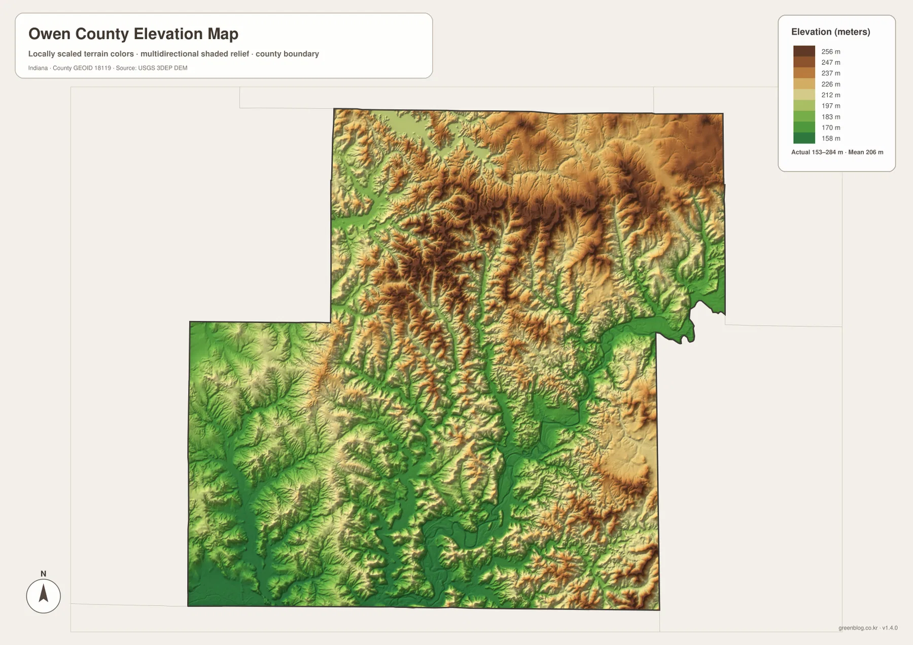
Spencer sits within a mixed landscape of creek valleys and moderate hills. Moving south toward White River, the relief drops into a broader low corridor. Coal City and the southwestern county also contain substantial low ground, but short ridges remain common, so the area is not a flat plain. The elevation image helps explain why so many local roads curve around or between the hills.
Indiana DNR’s Cagles Mill Lake information adds useful northern context by describing Mill Creek, Cataract Falls, and the older bedrock landscape around the lake system. The county-scale elevation map is still meant for relative terrain comparison rather than site measurement. For parcel elevations, road grades, drainage design, or construction in Owen County, use original USGS elevation data or measurements from a qualified survey.
Keep Spencer fixed while matching roads to White River, Rattlesnake Creek, and Cagles Mill Lake
For settlements and roads, begin with Spencer at State Road 46 and then add State Road 43, U.S. 231, and State Road 67. Move west to Patricksburg, southwest to Coal City, and northeast to Gosport. State Road 42 and the Cagles Mill Lake side provide a useful northern reference when the county’s stepped boundary becomes harder to follow.
The city index is the quickest way to compare Spencer and Gosport without the dense road and creek network. Return to the general map for Patricksburg, Coal City, or smaller road labels. The two printed city values belong to this map edition, so present-day Owen County population totals should come from a current official statistical source.
For physical geography, find White River first and then add Rattlesnake Creek, Lick Creek, and Raccoon Creek. In the north, switch to Cagles Mill Lake and Mill Creek. Matching those features to the elevation view reveals the main pattern: low river and creek corridors separated by short, steep ridges that become especially pronounced across the northern and eastern county.
The WebP images on this page are reduced previews. The Owen County archive contains four original 3638×2572-pixel JPG files covering the general county map, city index, terrain-and-water map, and elevation map. The full-size Owen County JPGs are the better choice when small road shields, creek names, lake labels, or hill details need to remain legible in print.
A useful comparison is to keep Spencer fixed as the main reference. Find Gosport, Patricksburg, and Coal City on the general map, compare Spencer and Gosport on the city index, move to the water view to locate White River and Cagles Mill Lake, and finish on the elevation image by comparing the broad low valleys with the tighter northern and eastern ridges.
Frequently Asked Questions
What is the county seat of Owen County?
Indiana county information and the Indiana State Library identify Spencer as the Owen County seat. On the supplied map, Spencer is the largest developed center and sits where State Road 46 connects with routes leading south toward U.S. 231 and State Road 67.
How do White River and Cagles Mill Lake help orient the map?
White River provides the main southern and southeastern lowland reference, while Cagles Mill Lake marks the northern edge with Mill Creek. Using both features separates the broad southern river valley from the more tightly cut northern hill-and-lake country.
Can the 153–284 m elevation range be used for exact site measurements?
No. The image gives a county-wide range with a mean of 206 meters and is intended for comparing river and creek lowlands with surrounding ridges. For an Owen County parcel, building site, road grade, or drainage project, consult original terrain data or a qualified survey rather than this county-scale relief image.
Map File Information
The Owen County ZIP combines the general road-and-place map, two-place city index, terrain-and-water map, and elevation map as full-resolution JPG originals.
- File Type: ZIP containing four 3638×2572px JPG files
Related Maps
Sources and References
The article is based primarily on the supplied Owen County map set and asset manifest. The following official sources provide county, Spencer, Cagles Mill Lake, boundary, hydrography, and elevation context.
- Owen County Government Offices – official county government and Spencer administrative information
- Indiana DNR – Cagles Mill Lake, Lieber & Cataract Falls SRA – official information on Cagles Mill Lake, Mill Creek, and Cataract Falls
- Indiana Historical Bureau – Owen County Courthouse – official historical context for Spencer and the county seat
- U.S. Census Bureau TIGER/Line Shapefiles – boundary reference for Owen County and its place framework
- USGS National Hydrography – reference data for White River, creeks, and mapped lakes
- USGS 3D Elevation Program – source terrain data for detailed elevation work
Green Map creates custom-edited map images using open geographic data sources such as geoBoundaries, Natural Earth, OpenStreetMap, and government open data.
These maps are edited visual materials, not raw data files, and are provided for education, documents, presentations, and graphic reference.