Pearl River County stretches across a large part of southern Mississippi, with Poplarville in the northern half and Picayune near the south end connected by the I-59 and US 11 corridor. The county also changes noticeably from the low, winding Pearl River side in the west to higher pine-covered hills toward the north and northeast. This page brings those patterns together in boundary, city, water, and elevation views, and the matching high-resolution A3 JPG map files can be downloaded as one ZIP archive.
The maps are most useful when read together rather than as four versions of the same picture. One view explains roads and the unusual county outline, another isolates the two main cities, the water map shows a dense network of creeks and small lakes, and the elevation surface makes the west-to-east terrain contrast immediately visible. That combination is especially helpful here because settlement, roads, streams, and relief do not all follow the same pattern.
Table of Contents
A long county between Poplarville and Picayune
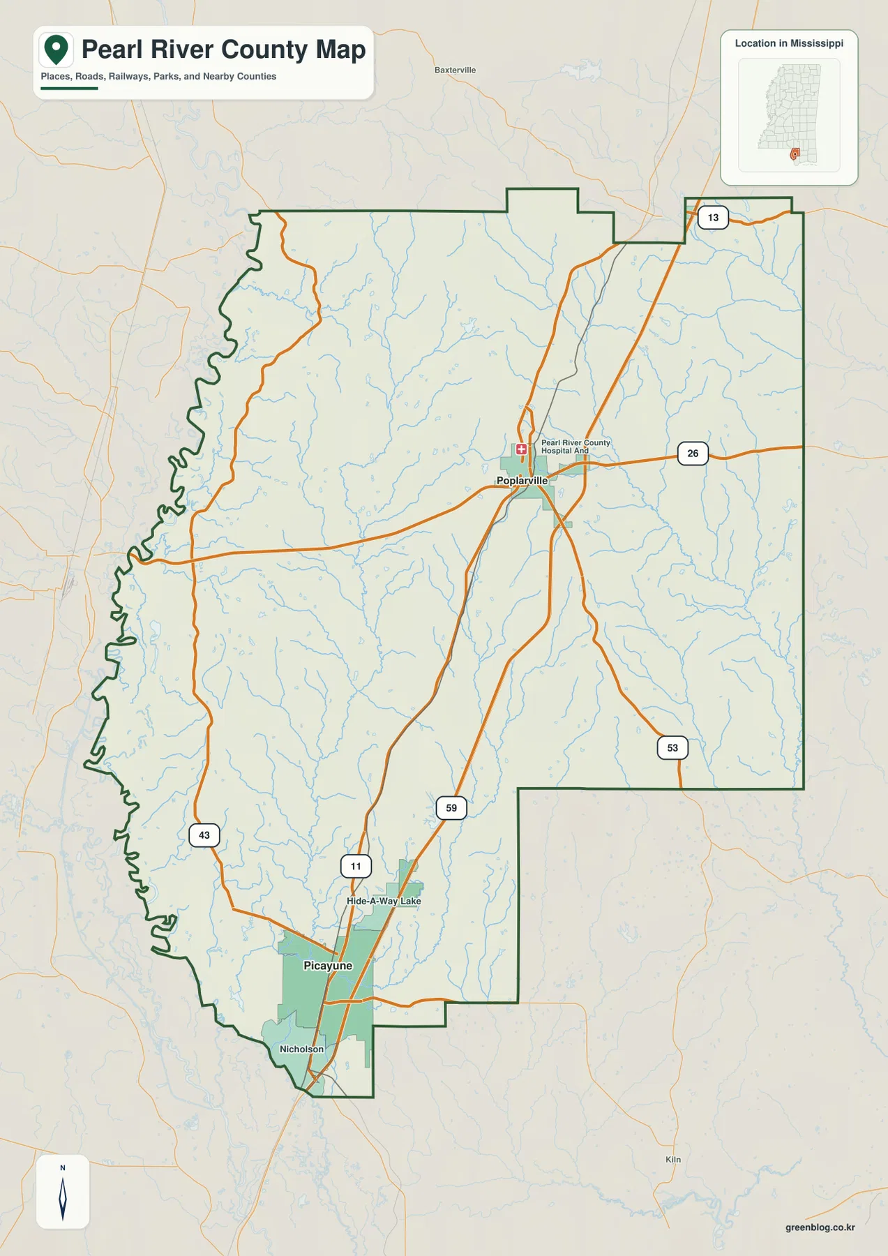
The county reference map makes the north-south shape clear. Poplarville sits near the middle of the northern half, while Picayune lies much closer to the southern edge. Nicholson and Hide-A-Way Lake appear nearby in the south. I-59 and US 11 provide the strongest continuous road connection between the two principal centers, so a traveler moving through the county sees a long sequence rather than one compact urban area.
Several state routes give the interior a second layer of structure. MS 26 crosses Poplarville from west to east, MS 43 runs down the western side, and MS 53 and MS 13 appear on the eastern and northeastern side of the county. Those roads help explain why Poplarville functions as a crossroads even though Picayune is the larger southern city. The map is still a county-scale reference, however, so subdivision streets, local forest roads, and minor access roads are intentionally simplified.
The boundary is just as distinctive as the road network. Much of the eastern side follows straighter administrative segments, while the western edge bends repeatedly along the Pearl River side. The county also has a broad indentation in the southeast and narrows again around the Picayune-Nicholson area. That irregular outline is one reason a county map is more useful than a simple city-to-city route diagram when placing Pearl River County among its neighbors.
The I-59 corridor separates the county seat from the larger city
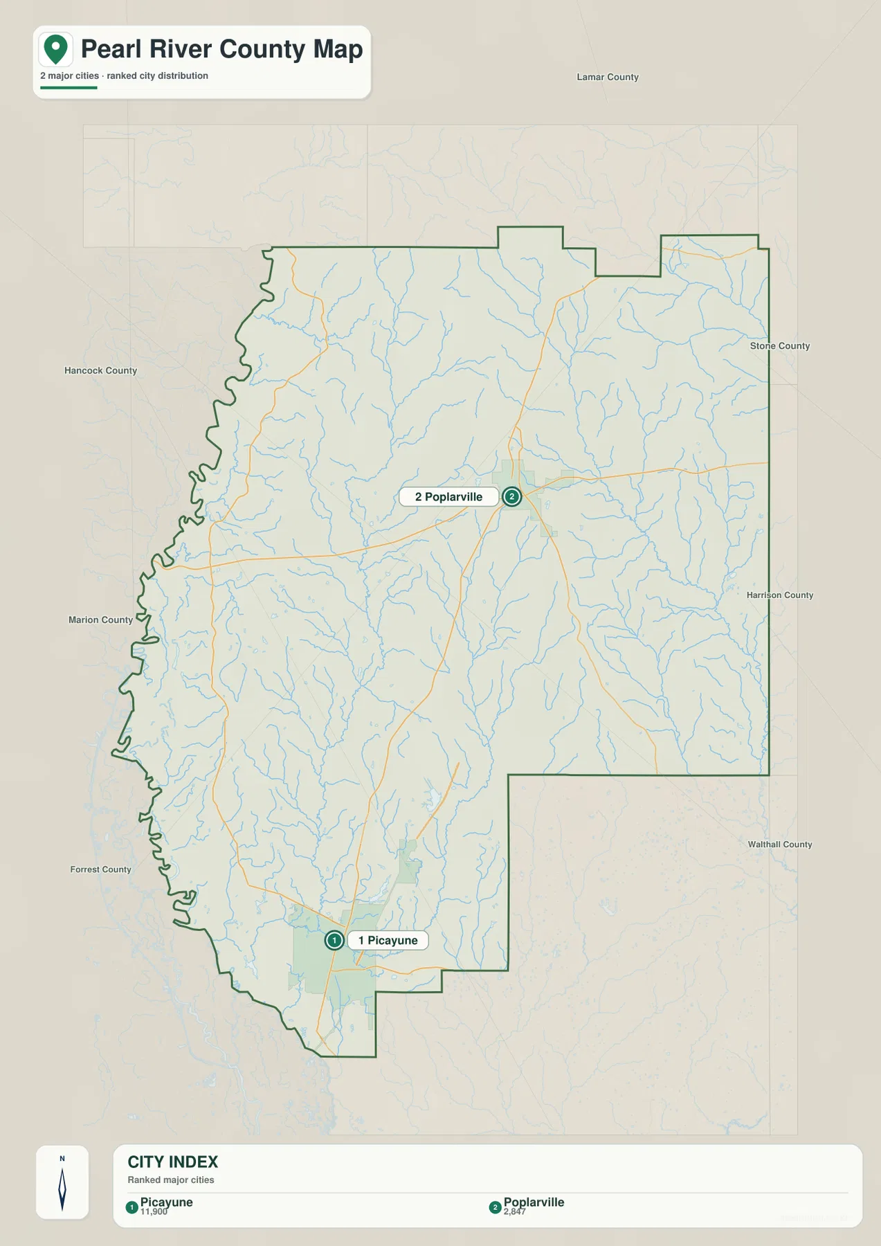
The city map deliberately strips away most smaller place labels and emphasizes Picayune and Poplarville. Its city index lists Picayune at 11,900 and Poplarville at 2,847. The important point is not simply that one number is larger: Poplarville is the county seat, while Picayune forms the stronger population and commercial center in the south. Administrative importance and urban size therefore sit in different parts of the county.
That split helps explain the role of I-59 and US 11. Poplarville anchors the northern part of the corridor, and the same general route continues south toward Picayune and the Louisiana approach. The current county material also identifies communities such as McNeill and Carriere between the two main centers, although the ranked city preview itself labels only Picayune and Poplarville. Reading the map this way avoids treating the city index as a complete list of every community in the county.
Neighbor labels provide useful regional orientation. Lamar County lies to the north, Stone and Harrison counties are on the eastern side, and Walthall County appears beyond the southeastern part of the outline. Hancock, Marion, and Forrest counties are shown around the west and southwest. On the western side, the Pearl River system also provides an important reference toward Louisiana. Together, those labels place the county between inland Piney Woods country and the broader Gulf Coast-New Orleans sphere to the south.
Elevation rises from the Pearl River lowlands into northeastern hills
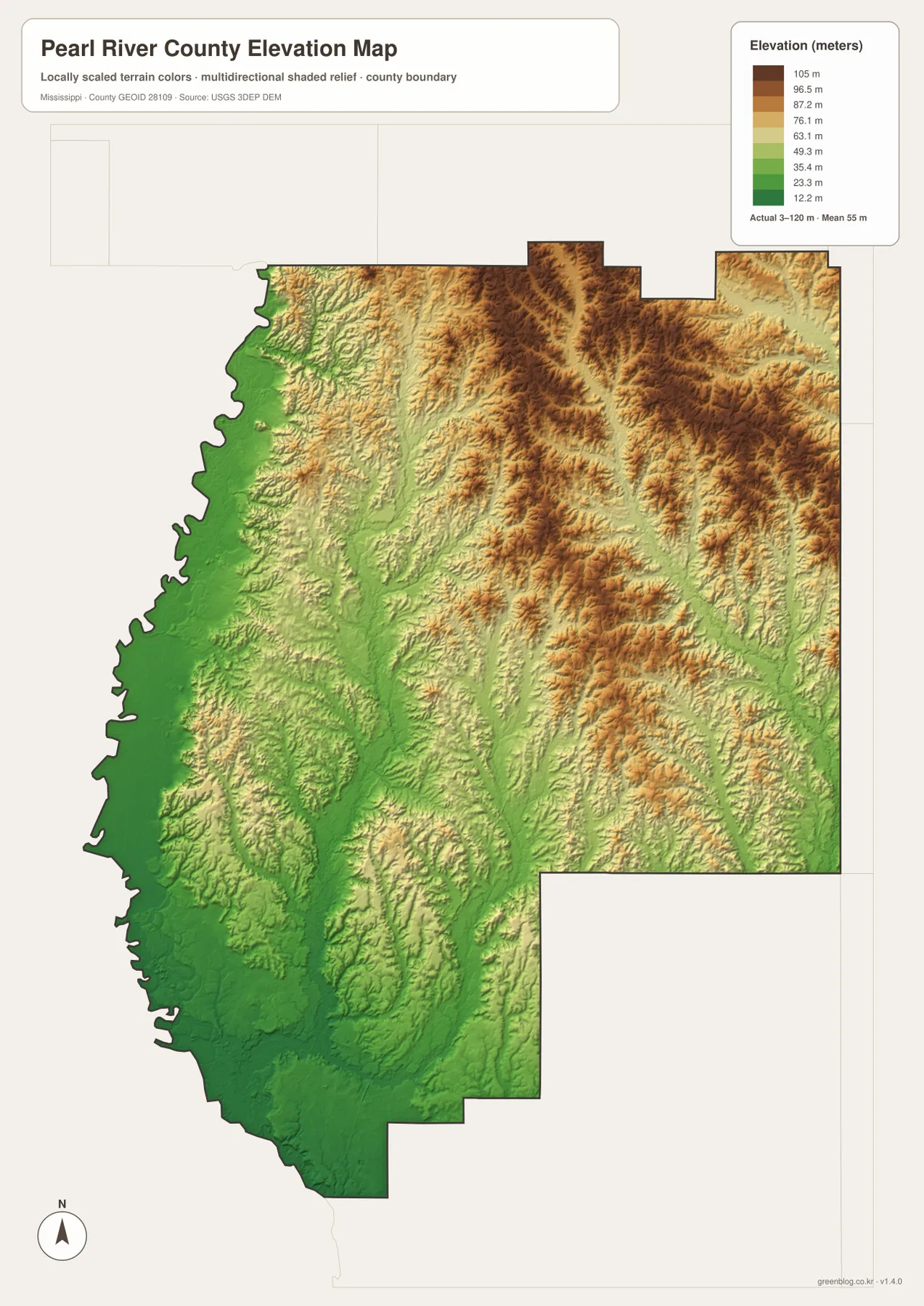
The elevation map reports an actual range of about 3 to 120 meters and a county mean of 55 meters. Darker greens dominate the western edge and the southern end, while tan and brown tones become much more common across the north-central and northeastern parts of the county. The change is not a single escarpment. Instead, many narrow ridges and valleys create a rolling surface that becomes progressively more pronounced away from the low Pearl River side.
This terrain difference helps connect several features that look separate on the other maps. The winding western boundary occupies some of the lowest ground. Farther east, streams cut through a more dissected landscape, producing long green valleys between higher ridges. Poplarville sits closer to this transition zone, whereas the Picayune-Nicholson area is surrounded by lower colors overall. The map therefore adds a physical explanation for why the same county contains broad river lowlands and noticeably hillier Piney Woods terrain.
The elevation surface is intended for county-scale comparison, not engineering or parcel work. Its shaded relief and color classes make regional differences easy to see, but they should not be treated as survey-grade measurements for a building site, drainage project, or property boundary. For those purposes, a more detailed elevation product or field survey is necessary.
Creeks and small lakes fill the space between the ridges
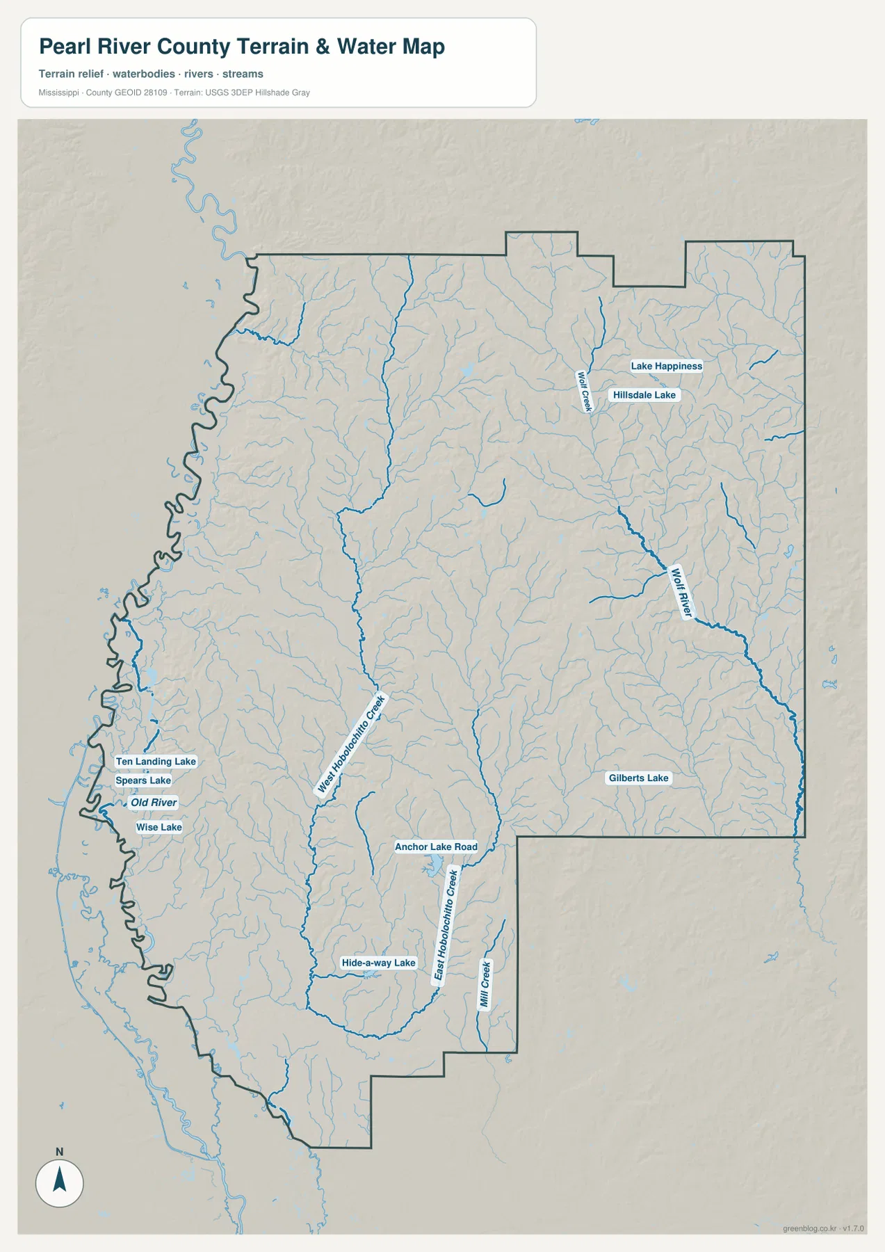
The water map shows how densely Pearl River County is crossed by small streams. Wolf Creek appears in the northeast near Lake Happiness and Hillsdale Lake, while Wolf River follows a stronger channel along the eastern side. In the central and southern parts of the county, West Hobolochitto Creek and East Hobolochitto Creek create two separate north-south drainage lines. Mill Creek is also labeled farther south. These channels do not simply parallel I-59, so the road and water maps reveal different ways the county is organized.
A cluster of small water bodies appears near the western lowlands: Ten Landing Lake, Spears Lake, Old River, and Wise Lake are all labeled close to the irregular west edge. Hide-a-way Lake appears farther south in the interior, and Gilberts Lake is mapped on the eastern side. When these labels are compared with the elevation colors, the concentration of water around low ground makes much more sense than it does on a road-only map.
This is a water-reference and terrain map, not a flood-risk, navigation, or legal-boundary product. A blue stream line shows the mapped location of a water feature at county scale; it does not establish whether nearby land floods, whether a channel is navigable, or where a surveyed property line lies. The practical use here is to understand the relationship among waterways, low terrain, roads, and communities.
Population and area put the map’s large footprint in context
| Measure | Value |
|---|---|
| County seat | Poplarville |
| FIPS code | 28109 |
| 2020 census population | 56,145 |
| July 2025 population estimate | 59,363 |
| 2025 Gazetteer land area | 811.508 sq mi |
| 2025 Gazetteer water area | 7.836 sq mi |
| 2020 population divided by 2025 land area | about 69.2 residents per sq mi |
Pearl River County covers more than 811 square miles of land, which helps explain why Poplarville and Picayune feel far apart on the map and why there is so much rural space between major labels. The 2020 census counted 56,145 residents, while the July 2025 estimate is 59,363. Those figures come from different reference dates, so the later number should be read as an estimate rather than as a second decennial census count.
Dividing the 2020 population by the 2025 Gazetteer land area gives about 69.2 residents per square mile. That countywide average does not mean people are distributed evenly. The city map shows a substantial difference between Picayune and Poplarville, while the water and elevation maps show broad river lowlands, wooded hills, and stream valleys where settlement is much less concentrated. The average is useful for scale, but the maps explain the uneven geography behind it.
Choose the view that matches the question
For basic orientation, the county reference map is the best starting point because it combines the boundary, Poplarville, Picayune, Nicholson, and the major road network. The city map is more useful when the question is specifically about the two principal centers and their different roles. It removes much of the background detail and keeps attention on the large separation between the county seat and the larger southern city.
The water map is the stronger choice for explaining the Pearl River side, the Hobolochitto Creek branches, Wolf River, and the small lakes that occupy low ground. The elevation map answers a different question: why the west and south look flatter while the north and northeast become more rugged. In a presentation or lesson, pairing the road map with either the water or elevation view can make the relationship between human routes and physical terrain much easier to explain.
The on-page images use WebP previews for faster viewing. For printing, offline reference, or editing, the ZIP below contains the matching original high-resolution JPG files in an A3 layout. The archive includes the county reference map, city map, water and terrain map, and elevation map.
Frequently Asked Questions
Does the Pearl River make up the entire western county boundary?
The Pearl River system is an important reference for the Louisiana-facing side of the county, but the full boundary should not be imagined as one smooth, uninterrupted main channel. The map shows a winding west edge and lowland water features, so the administrative line and individual river channels need to be read carefully rather than treated as identical everywhere.
Why are Poplarville and Picayune both important on the map?
Poplarville is the county seat and the administrative center. Picayune, however, is the larger city in the map’s ranked city index and forms the stronger southern population and commercial center. Showing both locations prevents the common assumption that the county seat must also be the largest city.
Can the 3–120 meter elevation range be used for site-level engineering?
No. The elevation map is designed to compare broad terrain across the county, such as the low Pearl River side and the higher northeastern hills. It is not a survey-grade surface for construction, parcel drainage, or precise site elevations. Those tasks require more detailed official elevation data or a professional survey.
Map File Information
The Pearl River County map set is packaged as original high-resolution A3 JPG files for printing and reuse.
- Included Files: 4 JPG maps
- File Type: JPG
Related Maps
Sources and References
- U.S. Census Bureau QuickFacts – reference for the 2020 population and July 2025 estimate.
- U.S. Census Bureau 2025 Gazetteer Files – reference for county land and water area.
- Mississippi Department of Transportation official highway map – reference for major state and federal routes.
- USGS National Hydrography – official reference for rivers, streams, and mapped water features.
- USGS 3D Elevation Program – official reference for elevation data.
- Pearl River Community College – county institution reference for Poplarville’s educational role.
Green Map creates custom-edited map images using open geographic data sources such as geoBoundaries, Natural Earth, OpenStreetMap, and government open data. These maps are edited visual materials, not raw data files, and are provided for education, documents, presentations, and graphic reference.