Vanderburgh County is centered on Evansville, where the county’s largest urban area meets the Ohio River lowlands and a broad network of roads and creeks. US 41 crosses the county from north to south, I-69 curves around the eastern side, and Route 66 provides an important east–west reference through the Evansville area. North of the city, Highland and Darmstadt provide separate inland markers, while Melody Hill extends the developed area toward the east. This Vanderburgh County Map page connects those places with Pigeon Creek, Little Pigeon Creek, western tributaries, the Ohio River edge, and a 104–185 meter relief surface. You can download the four 2572×3638 high-resolution JPG originals in one ZIP below, covering Vanderburgh County’s general, city, terrain-and-water, and elevation views for close inspection or A3 printing.
Evansville and US 41 are the easiest fixed references. US 41 continues north through the middle of the county, while I-69 forms a second north–south route on the eastern side. Route 57 is another northeastern reference, Route 66 crosses the urban area, and Route 62 approaches from the southwest. The road network becomes less dense beyond Evansville, where small communities, stream valleys, and rolling ground become more prominent.
The elevation map shows a strong contrast between the low southern part of the county and the higher western and northern ridges. Its legend reports an actual range of about 104 to 185 meters and a mean of 129 meters. Green low ground spreads across Evansville and the Ohio River side, while brown hills are concentrated in the west and northwest and reappear in the northeast. Pigeon Creek and other channels follow lower corridors between those uplands.
Table of Contents
Evansville connects US 41, I-69, and the county’s main road directions
Evansville is the clearest starting point on the general county map. US 41 runs north–south through the central county, and I-69 creates a broad eastern arc before continuing south. Route 66 crosses the Evansville area from west to east, while Route 57 provides another reference in the northeast. Route 62 reaches the county from the southwest. Together, these roads make the urban half of Vanderburgh County easy to organize.
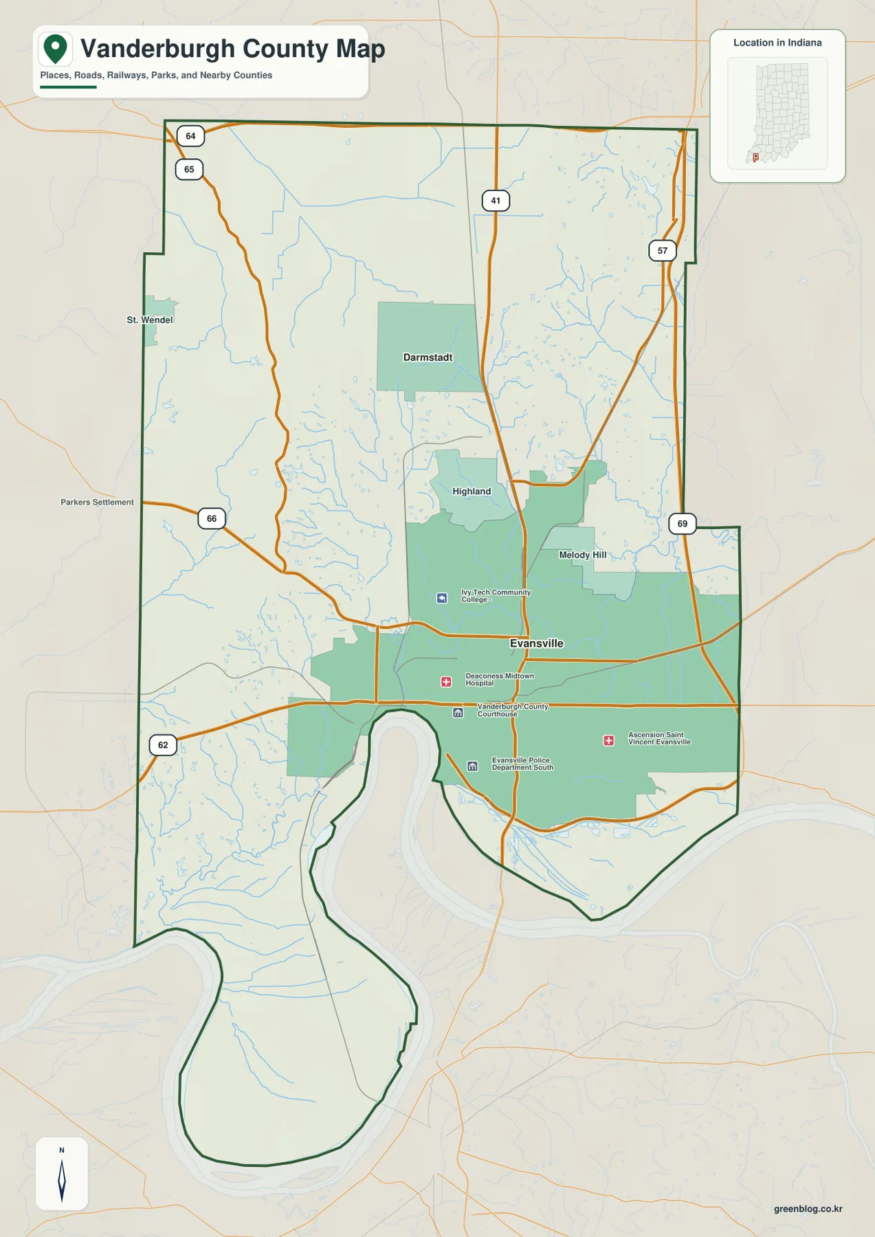
Highland sits north of the Evansville core near the US 41 side, while Darmstadt lies farther north in the interior. Their separation is easier to see once the dense southern city area is distinguished from the wider road spacing in the north. St. Wendel and Parkers Settlement also appear on the western side, where the terrain becomes more rolling and stream valleys are more visible.
Melody Hill lies east of the main Evansville center, close to the I-69 side of the developed area. The eastern road network is therefore easier to follow from I-69 and Route 57 than from US 41. This part of the county also contains several smaller drainage channels that become clearer on the terrain-and-water view.
The southern boundary follows the broad Ohio River bends rather than a straight line, so roads near the river also change direction. The general map is useful for named places, route direction, and county shape, but it does not track temporary construction, closures, or current travel restrictions. A live road source should be used for trip planning.
Evansville dominates the south while Darmstadt marks the northern interior
The city map highlights Evansville and Darmstadt, removing most secondary road detail and making the settlement pattern easy to see. Evansville occupies a large portion of the southern county, while Darmstadt sits well to the north in the interior. The two-name view makes the difference between the major southern city and the smaller northern community much clearer than the full road map.
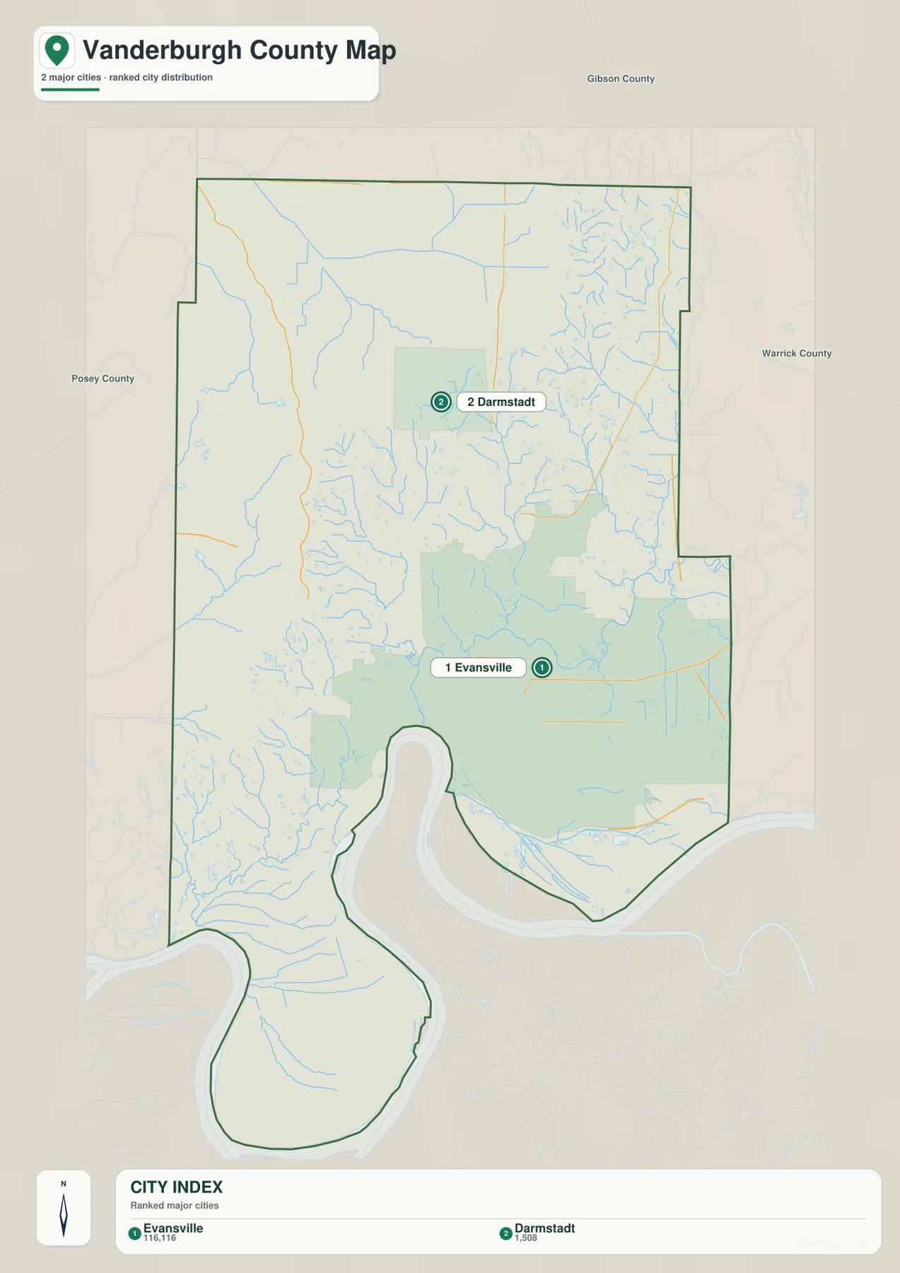
The CITY INDEX prints numeric values beneath Evansville and Darmstadt, but the supplied graphic does not state a statistical year or a separate source for those values. This page therefore does not present them as current official population. A recent U.S. Census release should be used when current population counts are needed.
Gibson County is labeled to the north, Warrick County to the east, and Posey County to the west. Those neighboring labels help place Vanderburgh County around Evansville and show why the major city sits close to several regional boundaries rather than in the geographic center of a large rural county.
The settlement pattern also helps organize the water map. Pigeon Creek and Little Pigeon Creek pass through the central and northern interior, while western tributaries such as Little Creek and Locust Creek occupy more rolling ground. Eagle Creek provides a separate southeastern water reference near the Ohio River side.
Pigeon Creek and Little Pigeon Creek form the main interior drainage corridor
Pigeon Creek is the strongest named interior water feature on the terrain-and-water map. It bends through the central county toward the Evansville side, while Little Pigeon Creek descends from farther north. Locust Creek joins the central drainage area from the west, and many smaller channels occupy the surrounding valleys.
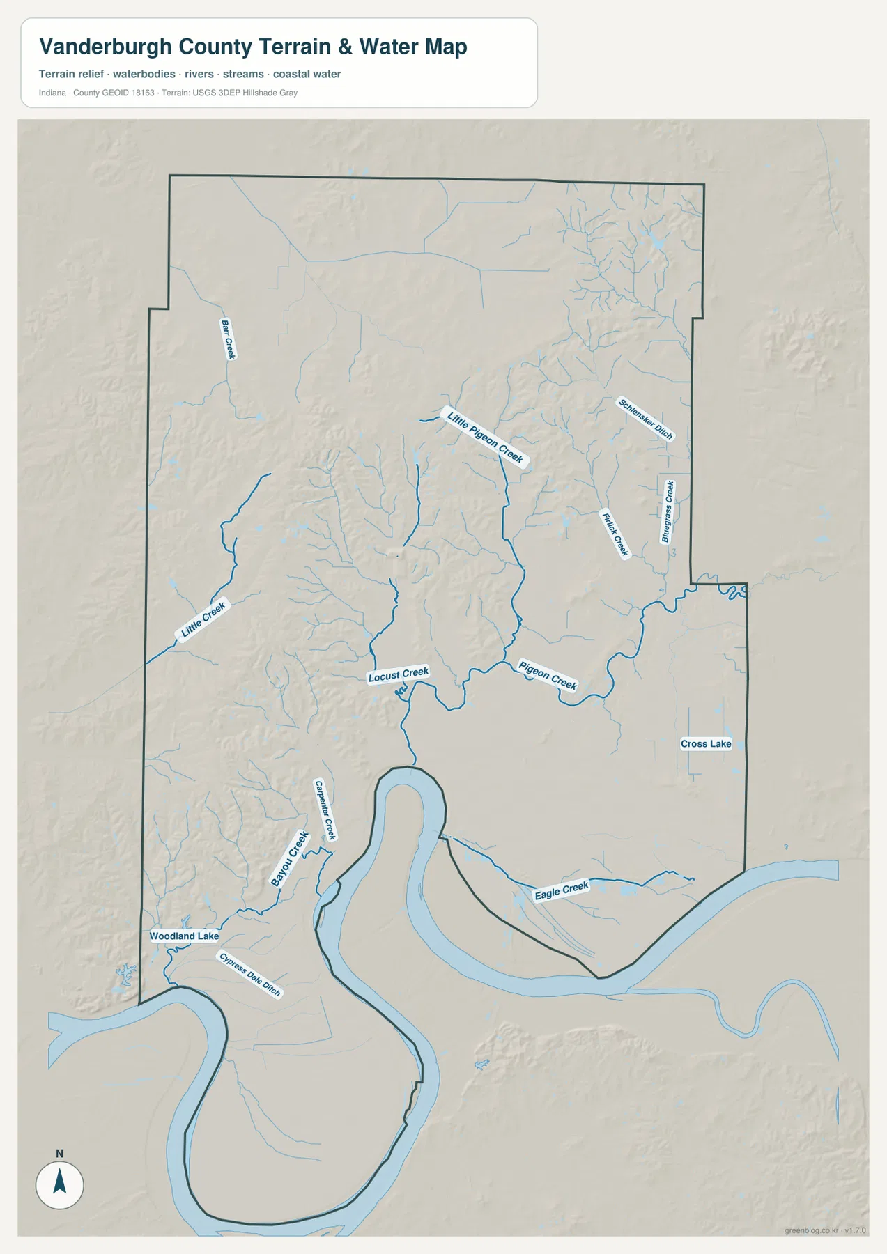
Little Creek curves through the western side, while Big Creek is labeled farther northwest. Near the southwest, Bayou Creek and Carpenter Creek descend toward the Ohio River lowlands, and Woodland Lake provides a separate small-water reference. These western channels occupy lower valleys inside some of the county’s highest terrain.
Eagle Creek crosses the southeastern interior toward the river side, while Cross Lake is labeled farther east. Schmucker Ditch and additional small channels appear in the northeast. The eastern half therefore has its own set of drainage corridors rather than being one broad flat surface.
Use this hydrology view to locate Vanderburgh County creeks, lakes, and drainage channels at county scale. It is not intended to define flood boundaries, parcels, legal water lines, water depth, or navigation conditions; those questions require current agency data created for those purposes.
The 104–185 meter surface separates the Ohio River lowlands from western and northern hills
The elevation legend gives Vanderburgh County an actual range of about 104 to 185 meters and a mean of 129 meters. Green low ground covers much of the Evansville area and the southern Ohio River side. The west and northwest contain much more tan and brown relief, and higher ridges also appear in the northeast. The contrast is strong enough to be visible even at county scale.
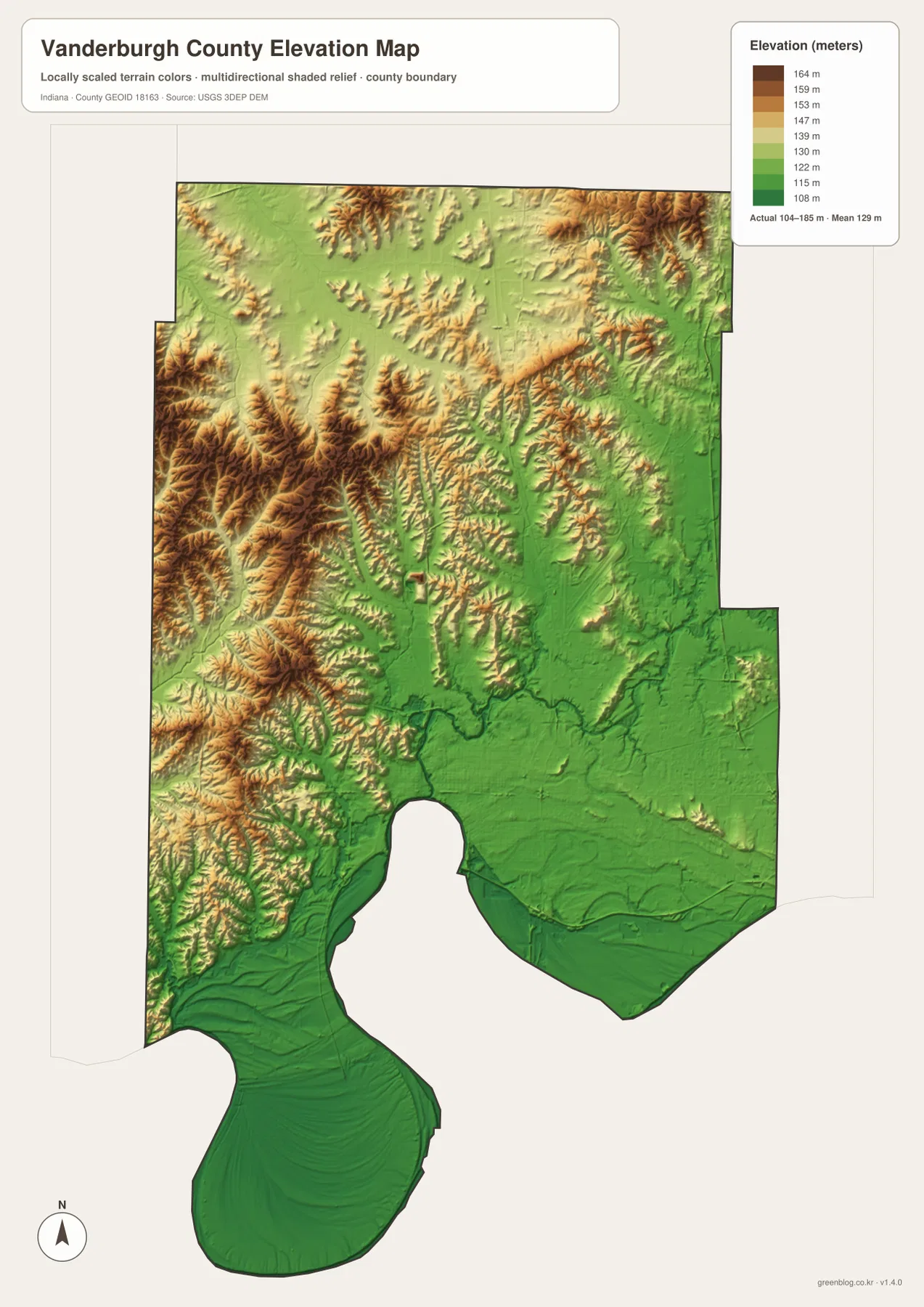
The western hills are deeply cut by small stream valleys. Little Creek, Locust Creek, Bayou Creek, and nearby channels align with green or light-green corridors inside the brown terrain. The result is a landscape of short ridges and hollows rather than one flat elevated block.
In the north and northeast, higher ground is also interrupted by Pigeon Creek and Little Pigeon Creek tributaries. Moving south toward Evansville, the surface becomes lower and broader until it meets the Ohio River lowlands. The physical map therefore explains why the urban area and the main central drainage system occupy much of the same lower part of the county.
The relief image is intended for broad comparison across Vanderburgh County rather than surveyed point elevations. If you need the exact elevation of a building, road point, field, or parcel corner in Vanderburgh County, use the underlying elevation data or a professional survey rather than this county overview.
Keep Evansville fixed while comparing roads, creeks, and elevation
For basic orientation, start with Evansville, US 41, I-69, and Route 66. The city view is cleaner when the only question is how Evansville and Darmstadt are positioned relative to one another. Once those two places are familiar, Highland, Melody Hill, St. Wendel, and the outer roads become easier to place.
For the physical landscape, find Pigeon Creek, Little Pigeon Creek, Locust Creek, and Eagle Creek on the water map. Then open the elevation image at the same locations. The southern city-and-river side remains low, while the western and northern margins rise into rolling hills cut by narrow drainage valleys.
The page uses smaller WebP previews for quick browser viewing. For Vanderburgh County, the ZIP preserves all four full-resolution JPG originals at 2572 by 3638 pixels: the general county, city, terrain-and-water, and elevation views. Those full-size files preserve more detail for Evansville-area roads, Pigeon Creek labels, and A3 printing.
A simple comparison routine is to keep Evansville fixed, locate US 41 and I-69, trace Pigeon Creek through the interior, and finish by comparing the green southern lowlands with the higher brown ridges on the west and north.
Frequently Asked Questions
What is the easiest place to use as a starting point on the Vanderburgh County maps?
Evansville is the easiest starting point because US 41, I-69, and Route 66 provide clear road references around the main urban area. From there, Darmstadt lies north, Highland is closer to the US 41 side, and Melody Hill extends east toward I-69.
Do the numbers in the Evansville–Darmstadt city index represent current population?
The supplied city graphic does not state a year or a separate statistical source for its numeric values, so this page does not present them as current official population. Use a recent U.S. Census release when current population figures are needed.
Where does the elevation map show the strongest terrain contrast?
The clearest contrast is between the low Evansville–Ohio River side in the south and the higher western and northwestern hills. The legend reports an actual elevation range of about 104–185 meters and a mean of 129 meters, with additional higher ridges in the northeast.
Map File Information
The ZIP contains four high-resolution JPG originals for Vanderburgh County: the general county map, city map, terrain-and-water map, and elevation map. Choose the original JPGs when you want to zoom in on Evansville-area road numbers, creek labels, or prepare an A3 print.
- Printable Size: 2572×3638 px each
Related Maps
Sources and References
The place, road, water, and elevation descriptions above are based on the supplied Vanderburgh County maps and asset information. The official references below can be used when more detailed source data or county information are needed.
- Vanderburgh County Government – official county government and local information
- U.S. Census Bureau TIGER/Line Shapefiles – official county boundary, road, and place geometry
- USGS National Hydrography – official river, creek, and inland-water information
- USGS 3D Elevation Program – official elevation-source and program information
Green Map creates custom-edited map images using open geographic data sources such as geoBoundaries, Natural Earth, OpenStreetMap, and government open data.
These maps are edited visual materials, not raw data files, and are provided for education, documents, presentations, and graphic reference.