Download four high-resolution JPG maps of McDonough County, Illinois, in one ZIP from this page, then use the article views to compare Macomb, Bushnell, Colchester, Argyle Lake, the La Moine River system, and the county’s elevation. Macomb sits near the middle of the county, while Bushnell is in the northeast, Colchester is southwest, and Industry is farther south. Across the northern half, Route 9 connects Sciota, Good Hope, and Bushnell in a clear east-west line that contrasts with the more branching road pattern around Macomb.
The terrain adds a second strong organizing feature. The northwest and north-central parts of McDonough County stand higher, while the La Moine River and East Fork La Moine River cut lower valleys through the center and southwest. Argyle Lake lies west of Macomb in a wooded, hilly setting, and several smaller lakes and creeks appear across the interior. The elevation map reports an actual range of about 124 to 245 meters, with a mean near 203 meters, so the difference between the uplands and the stream valleys is easy to see.
Table of Contents
Route 9 defines the north while Macomb organizes the center
The county map has two useful reference patterns rather than a single road hub. Macomb occupies the central area, where several roads meet around the courthouse and developed city blocks. Farther north, Route 9 runs almost straight from Sciota through Good Hope to Bushnell. That northern line gives the county a recognizable east-west corridor, while Macomb sits distinctly to the south and connects with Colchester, Industry, Bardolph, and Adair through separate routes.
Colchester lies southwest of Macomb, near Routes 336 and 110 on the western side. Industry is farther south along the Route 67 corridor. Bushnell has a north-south connection along Route 41, and the eastern edge includes Route 95 near Bardolph and Route 136 near Adair. Prairie City sits close to the northeastern boundary. The result is a county where northern towns are tied together by one strong road line, while central and southern communities are linked by several intersecting routes.
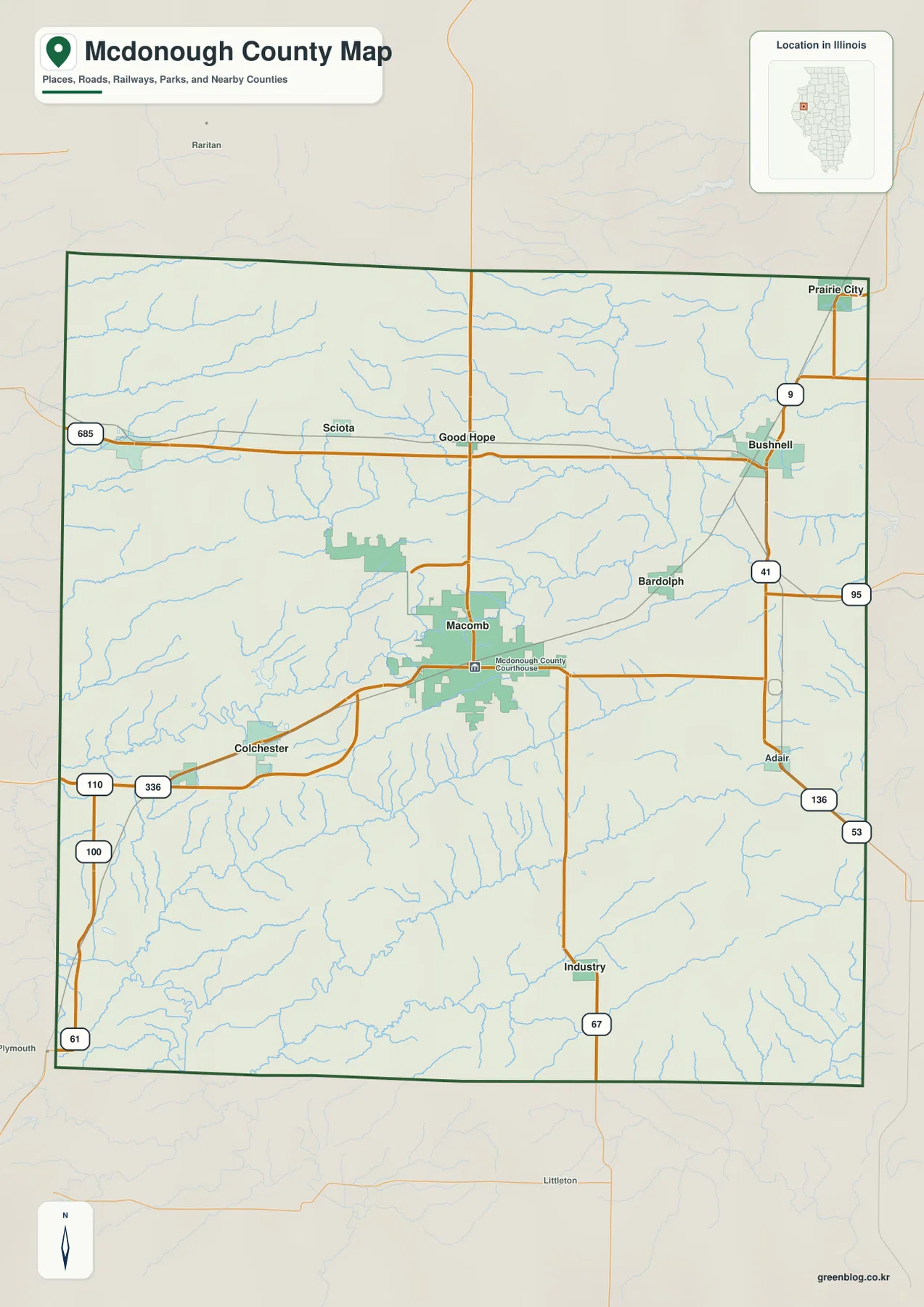
The surrounding labels also help with orientation. Raritan is shown beyond the northwest side, Plymouth appears outside the southwest corner, and the county’s eastern boundary sits close to Prairie City and Adair. These outside references make the county outline easier to place within western Illinois. The map is designed for geographic orientation rather than live navigation, so current traffic conditions, road closures, and driving times should still be checked with a dedicated road service.
Six ranked cities spread from Blandinsville to Industry
The ranked city map highlights six communities and removes most of the extra road detail. Its index lists Macomb at 14,894, Bushnell at 2,677, Colchester at 1,128, Blandinsville at 666, Industry at 569, and Good Hope at 438. Macomb is by far the largest highlighted place and sits near the center. Bushnell marks the northeast, Colchester the southwest, and Industry the south, while Blandinsville and Good Hope occupy the northern half.
The northern places are especially useful for showing the county’s width. Blandinsville lies near the western side, Good Hope is closer to the north-central area, and Bushnell is near the eastern side. On the general county map, Sciota and Route 9 fill in the space between them. South of that line, Macomb forms a separate central focus. Colchester and Industry then extend the settlement pattern toward the southwest and south rather than continuing the northern corridor.
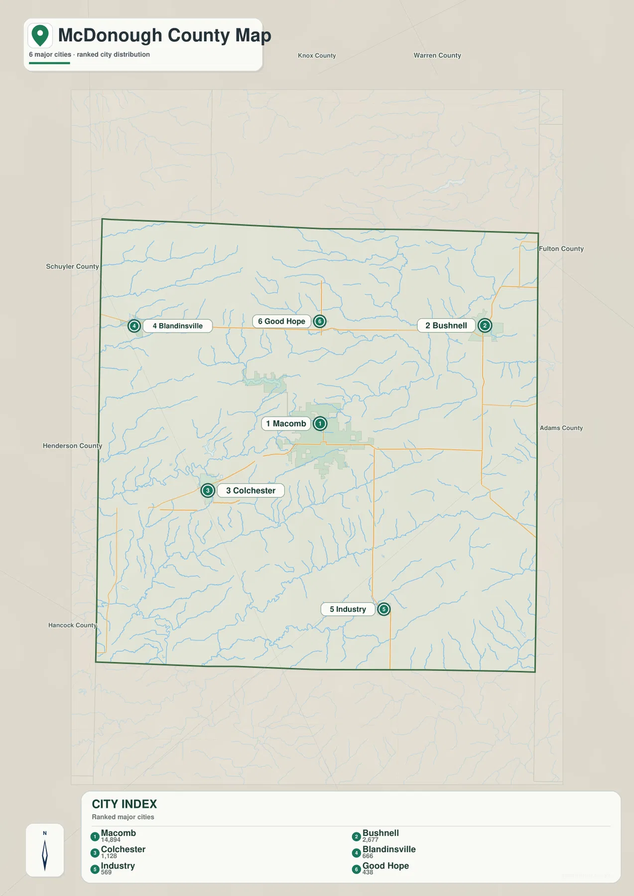
The city map is intentionally simpler than the county map. Find Bushnell or Colchester here first, then switch back to the road view to see the highways and smaller places around them. This avoids using the ranked map as a crowded road reference and makes the differences among the six communities easier to see. It also shows that McDonough County does not have one continuous urban strip; its towns are spaced across a broad rural landscape.
Argyle Lake sits beside the East Fork La Moine River valley
The terrain and water map is organized around the La Moine River system. East Fork La Moine River crosses the county through a long central valley, bending from the west toward the northeast. Argyle Lake lies west of Macomb close to that river corridor, while Spring Lake sits farther north. Illinois DNR describes Argyle Lake State Park as about 7 miles from Macomb and centered on a 93-acre lake within wooded, rolling terrain, which fits the hilly western setting visible on the supplied maps.
North of the East Fork, Farmers Fork approaches from the central-northern area and Drowning Fork runs through the northeast. Kepple Creek appears farther east. South Branch La Moine River follows the northwestern side, with Little Creek below it. These waterways occupy a network of shallow and deep valleys rather than a single straight drainage line. On the elevation map, many of the same channels appear as green cuts through higher tan and brown ground.
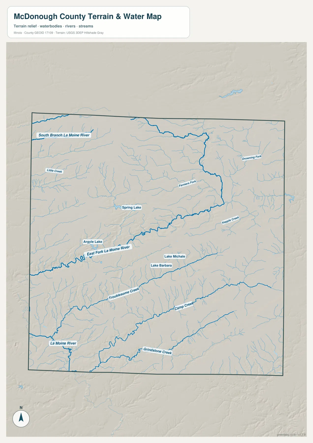
The southern half has another set of named channels. Troublesome Creek crosses the south-central interior toward the La Moine River, Camp Creek runs farther south, and Grindstone Creek appears near the lower edge of the county. Lake Michele and Lake Barbara sit close together near the middle-south area. The map is a geographic water reference rather than a flood-risk map, legal water-boundary product, navigation chart, or drainage-engineering document.
From 245 m uplands in the northwest to low La Moine River valleys
The elevation map reports an actual range of about 124 to 245 meters and a mean near 203 meters. The broadest high ground occupies the northwest and north-central parts of McDonough County, where brown and dark tan colors cover large areas. Small tributaries cut into that higher surface, so it remains rolling rather than perfectly flat. The southwest is much lower, with deep green terrain around the La Moine River and its tributary valleys.
A long lower corridor also follows East Fork La Moine River across the middle of the county. Around Macomb, the terrain sits closer to these middle and lower elevations than to the highest northwestern uplands. Farther east, the landscape becomes more subdued but still contains narrow green valleys and gentle ridges. Troublesome Creek and Camp Creek create additional low bands across the southern half, reinforcing the close relationship between the drainage network and the county’s relief.
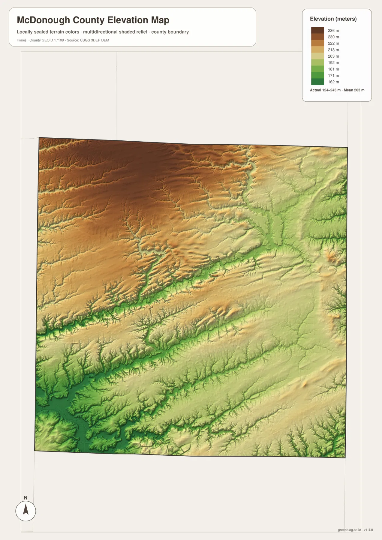
The elevation surface is generalized for county-scale comparison and should not be treated as survey-grade height, parcel elevation, or engineering data. For ordinary map reading, it is especially useful beside the water map. The East Fork La Moine River, Troublesome Creek, and Camp Creek line up with lower green corridors, while the terrain around Argyle Lake and the northwest rises into broader hills and uplands.
Read Macomb, Argyle Lake, and Bushnell across the four maps
Use the county map when roads, the full settlement pattern, and the county boundary matter most. The ranked city map is better for comparing Macomb, Bushnell, Colchester, Blandinsville, Industry, and Good Hope without extra labels. The terrain and water map is the clearest view for Argyle Lake and the La Moine River system, while the elevation map explains the contrast between the higher northwest and the lower central and southwestern valleys.
Macomb is a useful place to follow through all four views. The county map shows its central road position, and the city map shows how much larger it is than the other highlighted communities. The water map places it near the East Fork La Moine River valley, while the elevation map shows that this central area is lower than the broad northwestern uplands. Argyle Lake adds a western example of lake, creek, and hill relationships, and Bushnell provides a northeastern reference tied to Route 9 and a different set of small valleys.
Frequently Asked Questions
Which map is best for comparing Macomb, Bushnell, and Colchester?
The ranked city map is the quickest comparison. Macomb is central, Bushnell is northeast, and Colchester is southwest. Good Hope and Blandinsville occupy the northern half, while Industry is farther south. Switch to the county map when you also want Route 9, the Macomb road network, and the smaller settlements between the highlighted cities.
Why are the southwest and river valleys lower on the McDonough County elevation map?
The La Moine River, East Fork La Moine River, Troublesome Creek, and other streams occupy lower valleys that appear green on the elevation map. The northwest and north-central parts of the county rise into broader tan and brown uplands. Comparing the water and elevation maps makes the relationship clear because the named rivers and creeks follow many of the same low corridors.
What files are included in the downloadable ZIP?
The ZIP contains four high-resolution JPG files: the county and road map, ranked city map, terrain and water map, and elevation map. Each image is 2572 × 3638 pixels. Smaller WebP versions are used in the article for faster viewing, while the JPG files are better for close inspection and print. The water and elevation maps are general geographic references rather than flood, legal-boundary, survey, or engineering products.
Map File Information
Download the McDonough County county map, ranked city map, terrain and water map, and elevation map together as high-resolution JPG files.
- Included Files: Use only the versions confirmed in the article and supplied images
- File Type: Use the confirmed download contents
- Intended Use: Printing, education, presentations, and map-based projects
Related Maps
Sources and references
- U.S. Census Bureau TIGER/Line Shapefiles – county boundaries, roads, and place reference
- USGS National Hydrography – La Moine River, creeks, lakes, and other hydrography reference
- USGS 3D Elevation Program – elevation and terrain reference
- Illinois DNR – Argyle Lake State Park – official information about Argyle Lake and the hilly park landscape west of Macomb
- Macomb Area Convention & Visitors Bureau – local information for Macomb and McDonough County
Green Map creates custom-edited map images using open geographic data sources such as geoBoundaries, Natural Earth, OpenStreetMap, and government open data.
These maps are edited visual materials, not raw data files, and are provided for education, documents, presentations, and graphic reference.