Dade County occupies Georgia’s far northwestern corner, where the state narrows between Tennessee and Alabama. On a county outline it can look almost detached from the rest of Georgia, but the terrain explains why the boundary and transportation pattern developed this way. Sand Mountain rises on the west, Lookout Mountain forms the high eastern side, and Lookout Valley runs between them with Trenton near the middle.
This page brings together four views of the same county: a boundary-and-road reference map, a city map centered on Trenton, a terrain-and-water map, and an elevation map. The images shown in the article are lightweight WEBP previews. A single download box farther down the page provides all four maps as high-resolution A3-proportioned JPG files in one ZIP archive, so readers can use the larger versions for print, presentations, or offline reference.
Dade is small enough that the same few landmarks keep reappearing, yet each map answers a different practical question. The county map is best for roads and surrounding places, the city view isolates Trenton, the water map makes Lookout Creek and smaller tributaries easier to trace, and the elevation map reveals the steep separation between the valley floor and the mountain plateaus. Reading them together is especially useful here because straight-line distance alone does not describe travel across the ridges.
Table of Contents
Why Dade County has such a distinctive corner-of-Georgia shape
Dade County touches Tennessee along its northern edge and Alabama along much of its western side. Walker County is the only Georgia county that directly adjoins it, on the east and southeast. That unusual arrangement gives the county an interstate setting unlike most of Georgia: Chattanooga lies just beyond the northern boundary, while routes toward northeastern Alabama continue south and west without first passing through another Georgia county.
The basic statistics also show how compact the county is. The 2020 Census counted 16,251 residents, and the July 1, 2025 estimate was 16,154. Land area in 2020 was 173.97 square miles, and the county FIPS code is 13083. Population is not spread evenly across that area because the valley floor provides the most continuous corridor for roads, services, and settlement.
| Item | Value |
|---|---|
| State | Georgia |
| County seat | Trenton |
| Established | 1837 |
| 2020 population | 16,251 |
| 2025 population estimate | 16,154 |
| 2020 land area | 173.97 sq mi |
| FIPS code | 13083 |
The county reference map is the best place to start because it shows the boundary together with the road network, streams, and a useful selection of local labels. Trenton sits in the central valley, with New England and Wildwood farther north. West Brow and Lookout Mountain appear toward the eastern high ground, while Chattanooga Valley outside the county helps orient the reader to the broader north Georgia–Tennessee setting.

Interstate 59 and U.S. 11 follow the long valley corridor through the county, linking Alabama, Trenton, and the Chattanooga area. Georgia 136 turns east from Trenton and climbs toward Lookout Mountain and Walker County, cutting across the direction of the valley rather than following it. Interstate 24 runs near the northeastern transportation zone close to Tennessee. The road pattern therefore mirrors the terrain: north–south travel is concentrated in the low corridor, while east–west travel has to cross higher ground.
Trenton is the single ranked city on the supplied city map
The city map intentionally simplifies the county to one ranked major city: Trenton. Because only one city is ranked, this edition does not draw city-to-city connector lines or show connector distances. The benefit is clarity. A reader can see immediately that the county seat is not at the northern state line or on the eastern plateau, but near the middle of the long valley that carries the main transportation corridor.
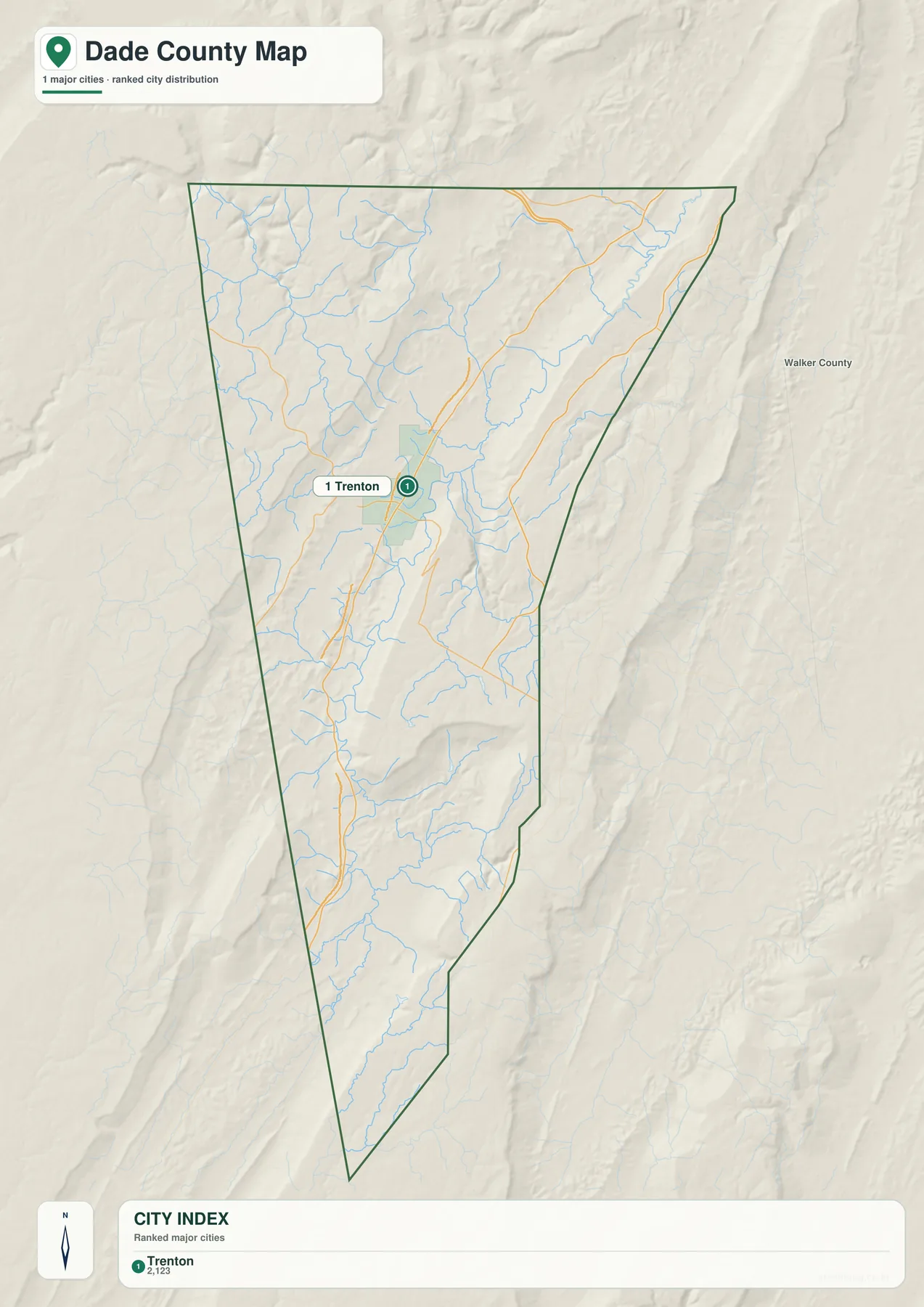
That central position makes Trenton a practical reference point for describing the rest of Dade. Wildwood and New England are north of town toward the Chattanooga side of the county, while Rising Fawn is south along the valley. Upland communities such as New Salem and Head River are better understood relative to the ridges rather than as part of one continuous urban strip.
The map should not be treated as a complete municipal directory. It is a ranked city-distribution graphic, so small unincorporated communities are not all labeled. It also does not imply that travel time is proportional to the distance seen on the page. A location on Lookout Mountain may appear close to Trenton in plan view, but drivers still have to gain substantial elevation on a limited set of mountain roads.
For a presentation, this city view is useful when the goal is simply to mark the county seat without the visual detail of every road and creek. For trip planning or local address work, the reference map and current navigation data are more appropriate. The simplified city map works best as an orientation image, especially when paired with the elevation view later on this page.
Lookout Creek and smaller tributaries define the water map
Dade County does not revolve around one large lake. Instead, the supplied water map shows a network of creeks and branches descending from the surrounding high ground into longer valley channels. Lookout Creek is the most prominent named waterway in the central and southern part of the county. Town Creek, Big Spring Branch, and Haddon Creek appear nearby, while the northern section includes Cole City Creek, Murphy Hollow Creek, Squirrel Town Creek, and Pole Creek.
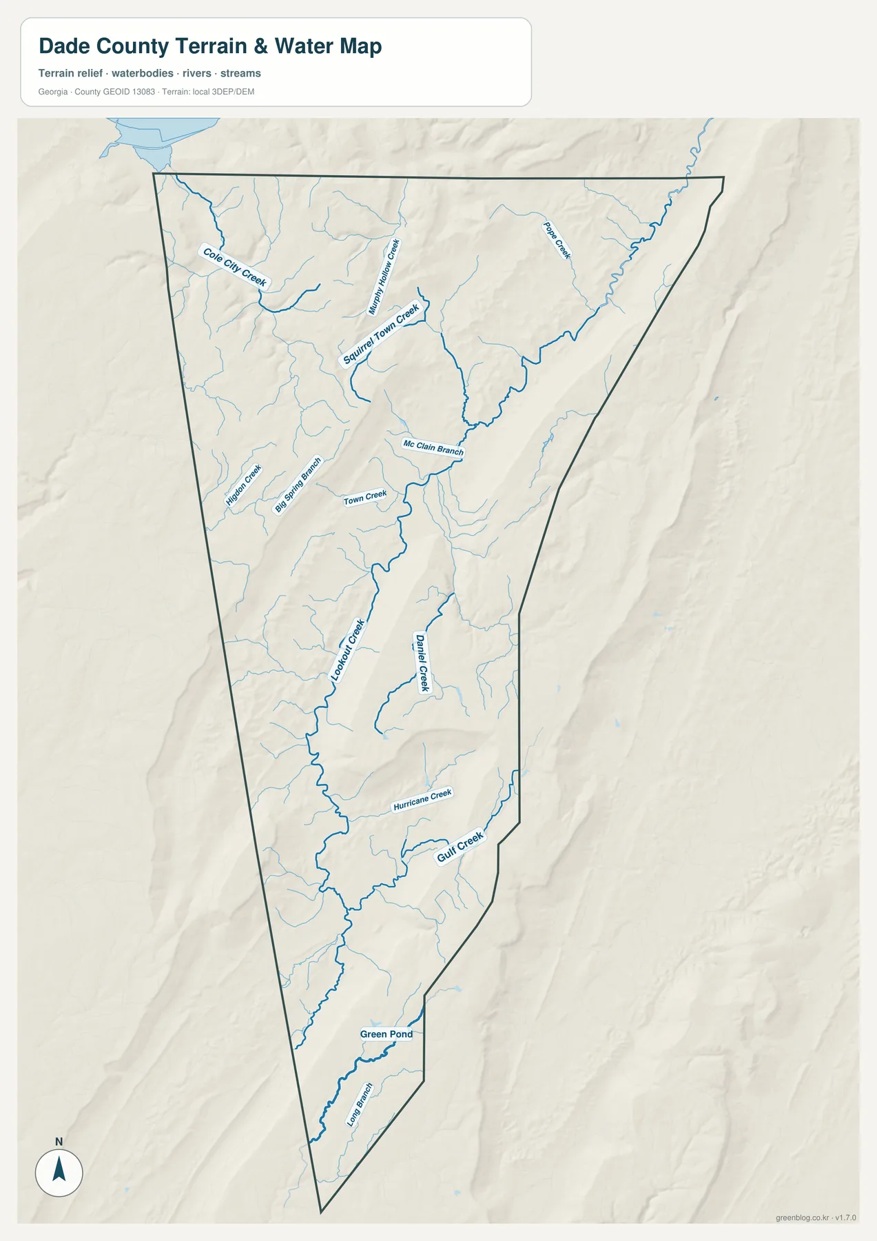
Farther east and south, Daniel Creek is labeled separately, followed by Hurricane Creek, Gulf Creek, Green Pond, and Leon Branch in the southern portion of the map. The shaded terrain behind the blue lines is important: many short tributaries begin on higher slopes and descend toward lower corridors, so their direction makes more sense when the relief is visible. The result is a county where water and topography are tightly connected even though no large body of water dominates the landscape.
Lookout Creek runs through the valley that also contains Trenton and the main north–south transportation corridor. Daniel Creek is especially useful for understanding the Cloudland Canyon side of the county. Existing county and park material describes Daniel Creek cutting through the canyon area and feeding waterfalls and cascades, which connects the water map to one of Dade County’s best-known natural landmarks.
This graphic is a county-scale water reference, not a flood-risk, parcel, boating, or emergency-navigation map. It does not supply real-time stream levels, property boundaries, crossing conditions, or regulatory flood zones. Anyone making a field, safety, construction, or access decision should use the current specialized source from the responsible agency.
The elevation map explains the mountain-and-valley contrast
The elevation image gives the clearest explanation for Dade County’s north–south organization. Its legend shows an actual elevation range of roughly 195 to 690 meters, with a mean of 394 meters. Lower ground is represented in green, while higher ridges and plateau surfaces shift through tan and brown. The central low corridor is therefore immediately visible between higher terrain on both sides.
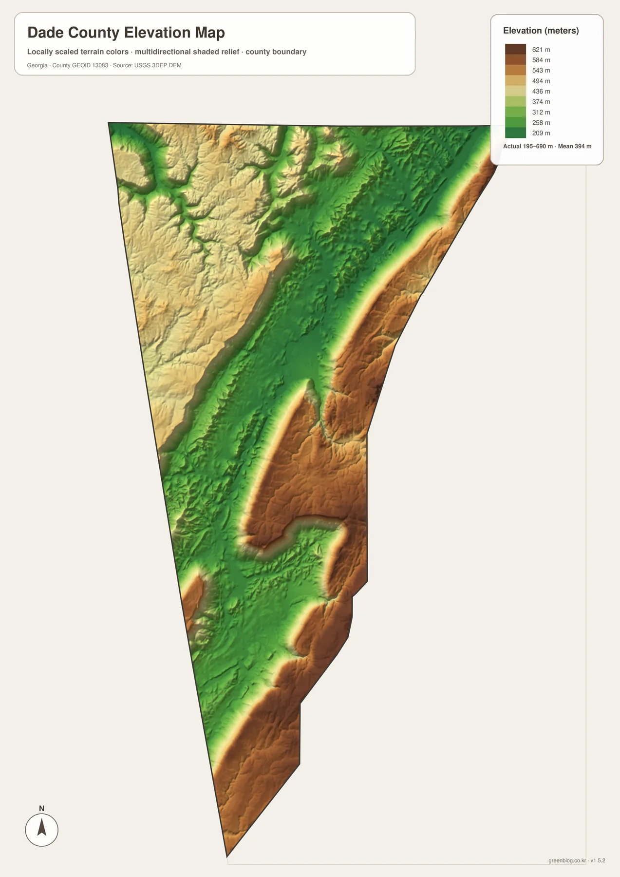
Lookout Mountain forms the most striking high band on the east. Sand Mountain also stands above the valley on the west, producing the broad three-part arrangement described in local planning material: western mountain, central valley, eastern mountain. Trenton occupies the lower middle corridor, which helps explain why the town, U.S. 11, and I-59 line up in the same general direction.
Cloudland Canyon sits along the western edge of Lookout Mountain, where the high plateau breaks sharply toward lower land. Georgia’s park material describes canyons approaching 1,000 feet in depth, along with sandstone cliffs, waterfalls, caves, and cascading streams. The county elevation map is generalized, but it still makes the setting of that canyon much easier to understand than a flat boundary outline can.
The elevation surface is not survey-grade data and should not be used to obtain engineering elevations or construction slopes at a specific property. Its purpose is regional comparison: which parts of the county are lower, where the mountain belts rise, and why roads crossing east or west may be more difficult than roads following the valley. Detailed topographic or engineering work requires a more precise source.
Cloudland Canyon, county history, and everyday connections beyond the state line
Dade County was created from western Walker County on December 25, 1837. It was named for U.S. Army Major Francis Langhorne Dade, who died during the Second Seminole War. Salem became the county seat in 1839 and was renamed Trenton the following year. The modern map still places Trenton in the geographic role that makes sense for an administrative center: in the valley, where the county’s principal road corridor is easiest to reach.
The mountains had a direct effect on transportation history. According to the county’s own historical account, motorists could not drive directly from Dade to the rest of Georgia before the state completed a road connection in 1939; they had to pass through Alabama or Tennessee. Georgia 136 now crosses from Trenton over Lookout Mountain toward Walker County. The story makes far more sense when the road map and elevation map are viewed together.
The familiar “State of Dade” nickname grew around that physical isolation. The county history page treats the popular claim of a formal 1860 secession as a myth rather than a documented independent state. For map readers, the more useful point is that geography created a real sense of separation even though the county remained part of Georgia.
Cloudland Canyon State Park is one of the strongest examples of the eastern plateau landscape. Georgia’s Department of Natural Resources lists the park at 3,538 acres and highlights deep canyons, sandstone cliffs, caves, waterfalls, and streams. Daniel Creek passes through this terrain, so the park links the elevation and water maps in a way that a simple county outline cannot show.
Agriculture remains another important piece of the county that is easy to overlook behind the mountain scenery. The 2022 Census of Agriculture recorded 180 farms covering 31,350 acres. Agricultural sales were about $52.65 million, with livestock, poultry, and related products accounting for 98 percent of sales value; the reported broiler inventory was about 1.69 million. Farms, timber tracts, rural estates, transportation development, and protected natural areas therefore occupy the same relatively small county.
Northern Dade also functions within the wider Chattanooga labor and service region. The previously compiled Census figure for mean travel time to work in 2020–2024 is 27.2 minutes, and the Wildwood area is included in a multistate transportation-planning context. These connections are a reminder that a state line on the map is an administrative boundary, not a complete description of where residents travel for work, shopping, education, or services.
Choosing the most useful map and downloading the full-size files
Start with the county reference map when you need boundaries, roads, place names, and a general sense of orientation. Use the city map when the single question is where Trenton sits inside Dade County. The water map is better for tracing Lookout Creek, Daniel Creek, and smaller tributaries, while the elevation map is the quickest way to explain the difference between the low central valley and the two mountain belts.
- County boundary, roads, surrounding communities, and general orientation: county reference map
- Simple county-seat location with minimal visual clutter: city map
- Lookout Creek, Daniel Creek, tributaries, and terrain relationships: water map
- Relative height, valley floor, ridges, and plateau edges: elevation map
The WEBP images on the page are intended for fast viewing. The downloadable archive contains four high-resolution JPG files at 2572×3638 pixels, matching an A3-style portrait layout. Those larger files are more suitable for printing, slides, worksheets, or documents where the labels need to remain readable at a larger size.
Each map still has limits. The county reference map is not a parcel or legal-boundary product, the city map is not a complete list of communities, the water map is not a flood map, and the elevation map is not an engineering surface. Use these files to understand the county and communicate its geography, then consult the current official specialist map when a decision depends on exact conditions.
Frequently Asked Questions
Which map is best for understanding why Dade County looks so narrow?
Use the county reference map together with the elevation map. The outline shows the long north–south county boundary, while the elevation colors reveal the lower valley between Sand Mountain and Lookout Mountain. That combination explains both the county’s shape and the concentration of roads through the middle.
Does the city map show distances from Trenton to other Dade County communities?
No. The supplied city map ranks only one major city, Trenton, so it does not draw city-to-city connector lines or list connector distances. It is intended to show the county seat’s position within the county. For driving distance or travel time, use current road and navigation data.
Can the water and elevation maps be used for flood, property, or engineering decisions?
No. The water map is a county-scale reference for named streams and terrain, not a flood-zone or navigation product. The elevation map shows generalized relative height and relief rather than survey-grade measurements. Property, safety, construction, and regulatory decisions require the current authoritative map for that specific purpose.
Map File Information
Dade County A3 map files
- Printable Size: 2572×3638 pixels each
Related Maps
- A Clinch County Map
- A Columbia County Georgia Map
- Adel and Little River on the Cook County Georgia Map
Sources and reference material
Population and land-area figures can be checked through the U.S. Census Bureau QuickFacts page for Dade County. The county’s formation, the 1939 road connection, and the “State of Dade” story are covered by Dade County’s official history page. Land-use and transportation context can also be reviewed in the Georgia Department of Community Affairs Dade County–Trenton comprehensive-plan record.
Agricultural figures come from the USDA 2022 Census of Agriculture county profile, while the canyon description and park acreage are available from Georgia DNR’s Cloudland Canyon State Park page. For the underlying types of official geographic data, readers can consult Census TIGER/Line, USGS National Hydrography, and the USGS 3D Elevation Program. These specialized sources should be used when a task requires more detail than the county-scale maps on this page.
Green Map creates custom-edited map images using open geographic data sources such as geoBoundaries, Natural Earth, OpenStreetMap, and government open data. These maps are edited visual materials, not raw data files, and are provided for education, documents, presentations, and graphic reference.