Linn County occupies the far eastern side of Kansas, where the county line meets Missouri and a network of small towns, creeks, lakes, and low river country spreads across a mostly rural landscape. Mound City is the county seat, while Pleasanton, La Cygne, Linn Valley, Parker, Prescott, and Blue Mound provide useful landmarks for finding different parts of the county. The maps on this page separate those features into clear views so you can follow roads, compare towns, trace waterways, and see the change in elevation from the western uplands toward the eastern river corridor.
High-resolution A3 JPG map files are available to download as well as the web previews shown below. The larger files are useful for printing, classroom work, presentations, or any project where small road and water labels need to remain legible. Instead of treating the maps as four copies of the same information, the guide below explains what each view adds and how the layers work together when you are trying to understand Linn County.
Table of Contents
Start with Mound City and the Missouri side of the county
The easiest way to orient yourself is to place Mound City near the south-central part of the county and then look east toward the Missouri state line. Pleasanton sits farther east, La Cygne and Linn Valley are in the northeastern part of the county, Parker is to the northwest, Blue Mound is toward the southwest, and Prescott lies near the southeastern side. That spread is important because Linn County does not revolve around one dense city center. Its communities are separated by farms, local roads, stream valleys, and open country.
The road pattern gives those place names a practical frame. US-69 runs through the eastern side near Pleasanton, while K-52 crosses the La Cygne area. K-7 provides a useful north-south reference near Mound City and continues toward the southern part of the county. When you are planning a route or simply trying to understand how two towns relate to each other, combining the road numbers with the town labels is more useful than looking at either one by itself.
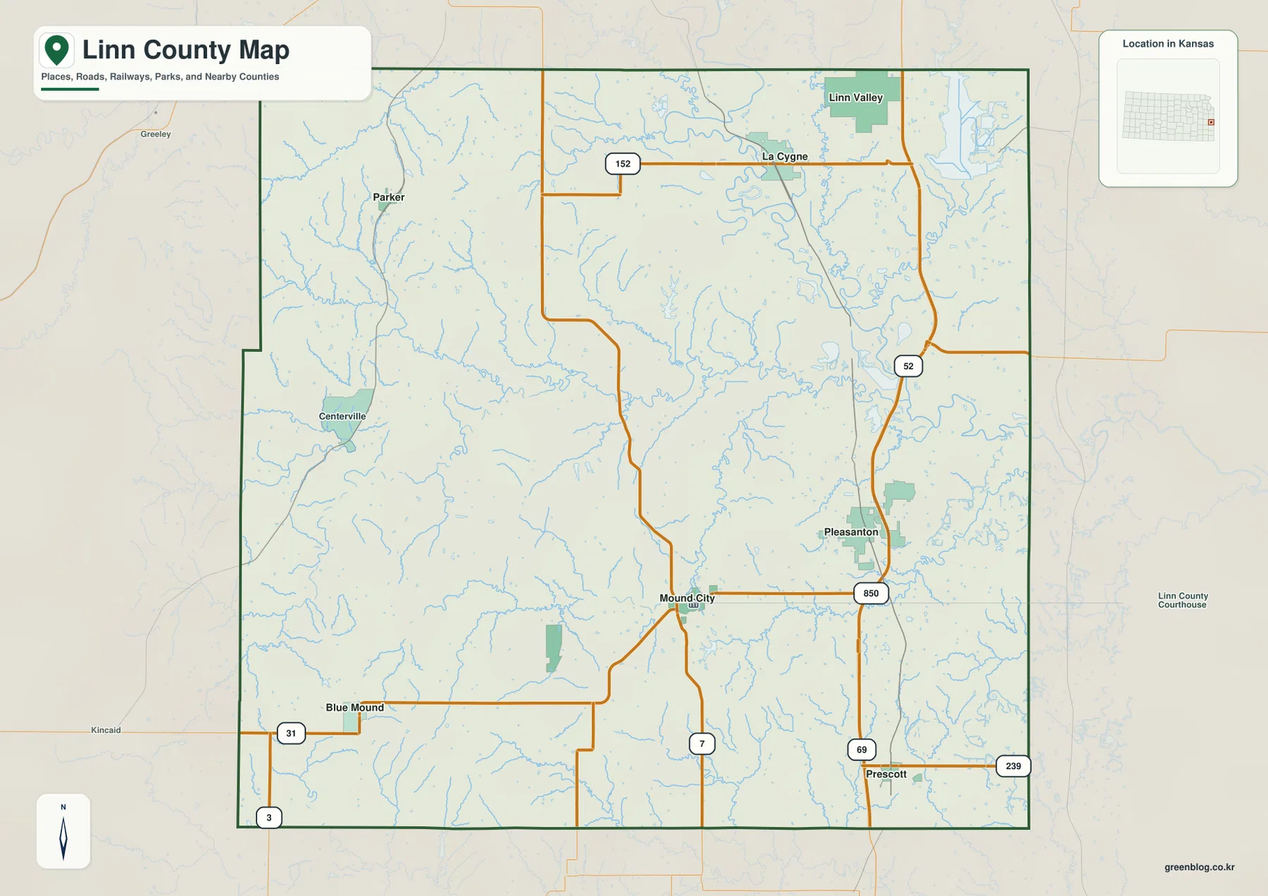
This general map works best as the first stop because it keeps the county in one frame. It shows how the eastern communities relate to the Missouri side, how Mound City sits farther inland, and how smaller roads fan out toward the west and southwest. The many blue stream lines also hint that water has a strong influence on the landscape even before you switch to the dedicated terrain-and-water map.
The six-city view shows how far apart Linn County’s communities are
The city map removes much of the road detail and makes the settlement pattern easier to compare. Pleasanton is the most prominent city in the index used on this map, La Cygne and Linn Valley form a northeastern group, Mound City sits lower and farther west, and Parker and Prescott occupy opposite sides of the county. The simplified design is useful when the question is not how to drive between towns but where the towns are relative to one another.
That distribution also explains why a single town label cannot stand in for the whole county. Someone looking only at Pleasanton would miss the northwestern placement of Parker, the southwestern direction of Blue Mound, and the administrative role of Mound City. Likewise, a reader focused on La Cygne may not realize how far south Prescott lies until the communities are shown together. The city map turns those relationships into a quick visual comparison.
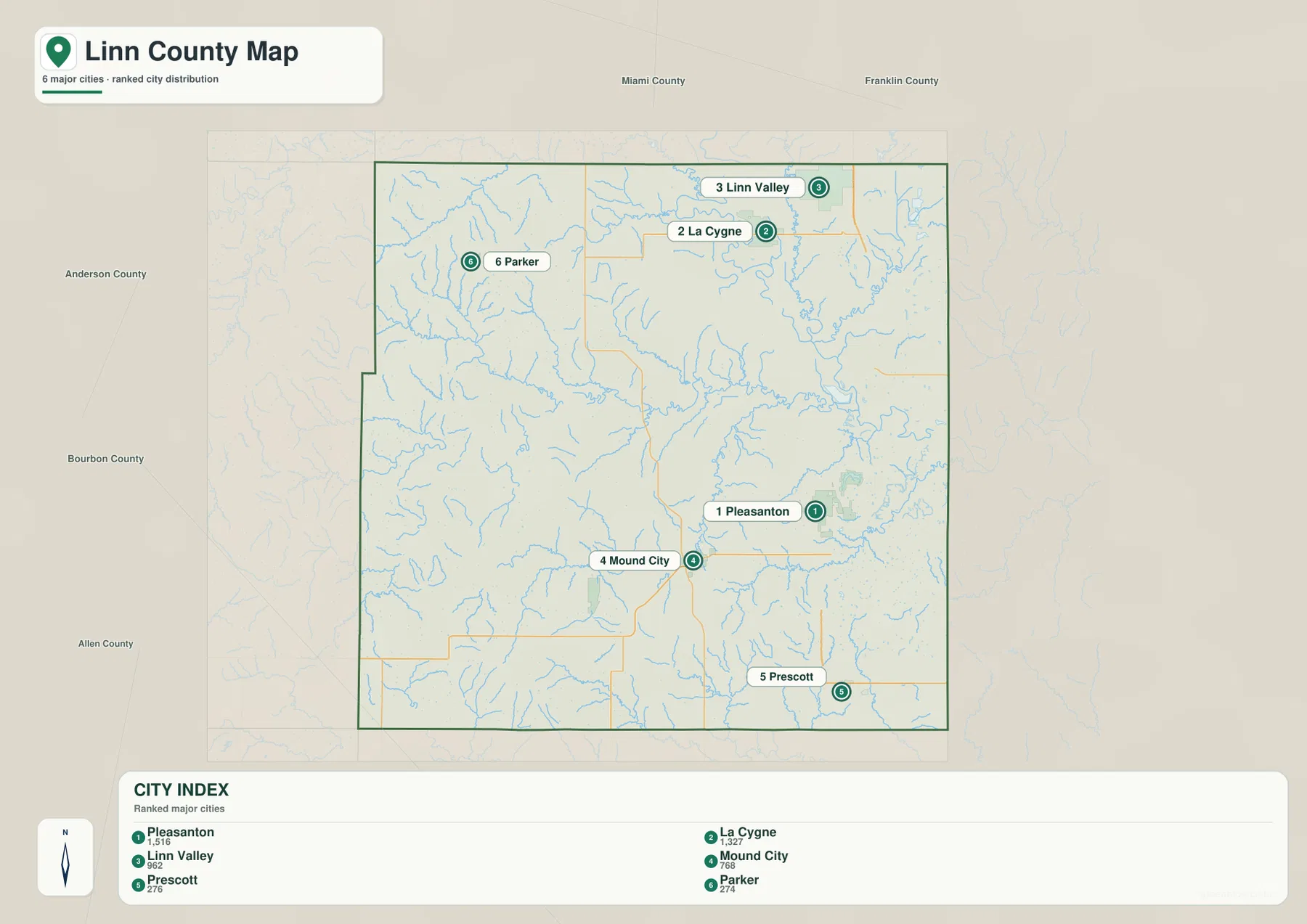
For school projects, presentations, or a simple county overview, this is often the cleanest map to use. If you need to explain a route, return to the general county map; if the question is why a town sits near a particular lowland or stream, move on to the water and elevation views. The maps are most useful when each is used for the job it handles best rather than trying to make one image carry every detail.
Marais des Cygnes and the Sugar creeks shape the eastern lowlands
The terrain-and-water map makes the Marais des Cygnes River the strongest feature on the eastern side of Linn County. The river bends through the northeastern and eastern part of the map, while tributaries such as Middle Creek and North Sugar Creek feed into the same broad drainage system. Farther west and south, Big Sugar Creek and Little Sugar Creek cross the interior, and Mine Creek provides another clear east-west water reference in the southeastern half of the county.
Several lakes add smaller landmarks to the drainage picture. Pleasanton Lake and Pleasanton City Lake sit near the Pleasanton area, while Lake De Lago appears farther west. City Lake, Johnson Lake, and Bradley Lake are shown in the southwestern portion of the map. These names make the water map useful for readers who are searching for a specific stream or lake and do not need the full road network competing for attention.
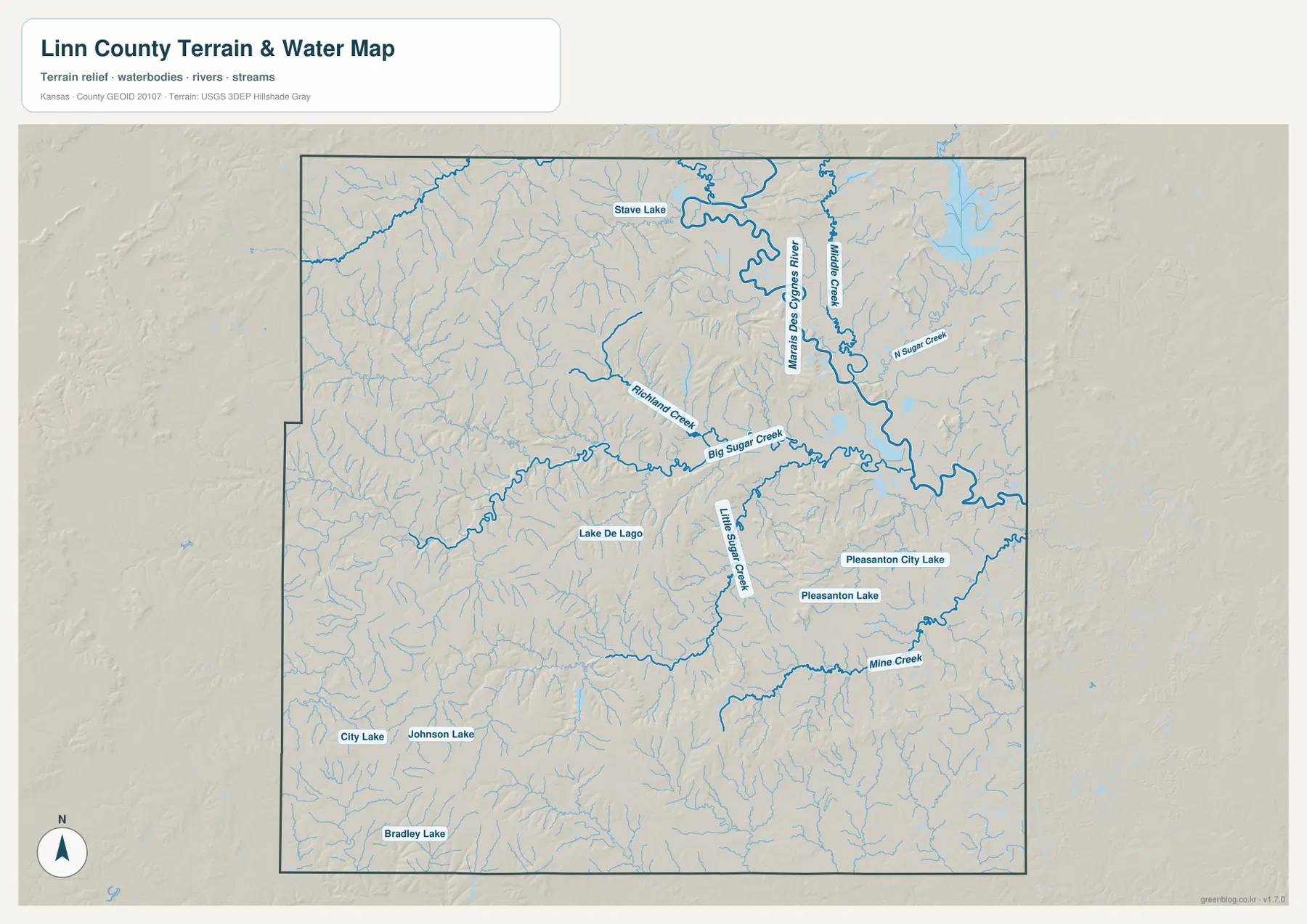
The shaded relief is just as useful as the blue water lines. Stream valleys cut into the surrounding land, and the Marais des Cygnes corridor occupies a noticeably lower part of the county than many areas to the west. This helps explain why the water network looks so dense: small tributaries descend from higher ground and eventually join larger creeks and the river system. It also gives a stronger geographic context to towns such as La Cygne and Pleasanton than a road-only map can provide.
Higher western ridges give way to lower river country in the east
The elevation map shows an overall Linn County range of about 229 to 342 meters, with a displayed mean of roughly 281 meters. The western and southwestern parts of the county contain more of the higher brown and tan terrain, while broad green areas mark lower ground toward the east and northeast. The county is not mountainous, but it is also not a perfectly flat plain. Numerous short ridges and shallow valleys create a textured surface across the western half.
The Marais des Cygnes River corridor is one of the clearest low areas. In the elevation view, lower terrain expands around the river and its tributaries, while higher ridges become more pronounced as you move west. Mound City lies in a useful transition zone between those two patterns. Pleasanton and La Cygne are associated with generally lower eastern terrain, whereas the Blue Mound direction includes more of the higher southwestern uplands.
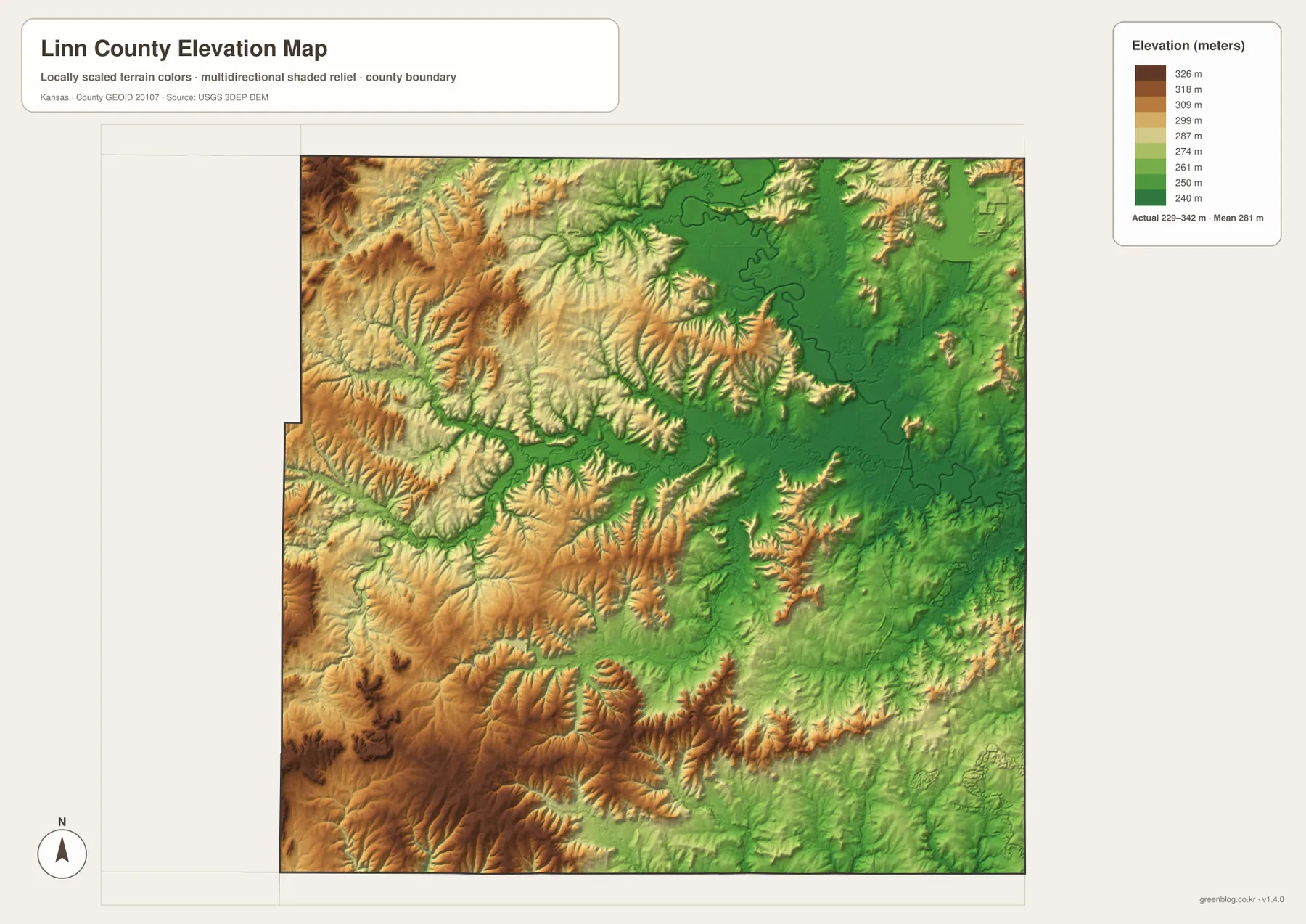
This map is appropriate for explaining county-scale relief, comparing ridges with valleys, or understanding why streams occupy particular corridors. It should not be used as a survey document for a parcel, building site, or engineering project. The colors summarize terrain over a broad area; precise work requires official elevation data, professional surveying, and the standards appropriate to the project.
Pleasanton and La Cygne show how the maps connect
Pleasanton is a useful example because several map layers meet there. On the general county map, the city is close to US-69 and sits well east of Mound City. On the water map, Pleasanton Lake, Pleasanton City Lake, Little Sugar Creek, and Mine Creek provide nearby natural references. The elevation view then adds the larger pattern: the eastern side around Pleasanton is generally lower than many of the ridges farther west.
La Cygne works in a similar way. K-52 gives the town a clear road reference, Linn Valley lies nearby to the north, and the Marais des Cygnes River curves through the surrounding northeastern landscape. Looking at those features together makes the town easier to place than simply memorizing a point on the map. It also shows why the eastern side of Linn County feels different from the rougher western terrain: the road network, towns, and waterways occupy a broad river-influenced lowland.
Mine Creek and Marais des Cygnes also anchor local history
Two names visible on the physical landscape appear repeatedly in Linn County history. The Kansas Historical Society describes the county as an important border-conflict area during the territorial and Civil War periods and identifies the Marais des Cygnes Massacre and the Battle of Mine Creek among its significant historic events. A modern map is not a reconstruction of nineteenth-century roads or troop movements, but locating Mine Creek and the Marais des Cygnes drainage gives readers a useful geographic frame before consulting historical maps and site-specific material.
The same approach works for a visit. First use the county map to understand where Mound City, Pleasanton, La Cygne, and the major roads are today. Then use the water map to locate the named creeks and river corridors associated with historic place names. Finally, consult the responsible historical agency or site operator for current access, hours, parking, trails, and any detailed interpretive maps. Keeping modern geography and historical reconstruction separate prevents a general county map from being asked to do more than it was designed to do.
Choose the map by the question you need to answer
Use the general county map when you need towns, major roads, streams, and the county outline together. Choose the city map when the relative positions of Pleasanton, La Cygne, Linn Valley, Mound City, Parker, and Prescott matter more than route details. The terrain-and-water map is the strongest choice for the Marais des Cygnes River, Sugar Creek branches, Mine Creek, or local lakes. The elevation map is best when you need to explain the higher western uplands and the lower eastern river country.
For printed work, the downloadable originals are preferable to enlarging the web previews. The archive contains four A3 high-resolution JPG files, so labels, shaded relief, and water names remain clearer on a large page. In presentations, keeping each map title and legend visible helps the audience understand what the colors and symbols mean. You can also place two maps side by side—for example, the city view next to the water view—to show how settlement locations relate to the drainage network without crowding everything into one image.
These maps are reference tools rather than legal or survey documents. They are well suited to general location checks, classroom geography, county comparisons, and visual explanations of roads, communities, waterways, and relief. For property boundaries, engineering elevations, emergency routing, or other tasks where precision affects a decision, use the appropriate official records and professional data source.
Frequently Asked Questions
Which map shows the Marais des Cygnes River most clearly?
Use the terrain-and-water map. It shows the Marais des Cygnes River as the large winding waterway in the northeastern and eastern part of Linn County and also labels tributaries such as Middle Creek and North Sugar Creek. The general county map includes the river too, but the dedicated water view is better when stream names and the surrounding low terrain matter.
What is the easiest way to compare Mound City and Pleasanton?
The city map gives the quickest position comparison: Mound City is south-central and Pleasanton is farther east. Use the general county map when roads are important because Pleasanton is close to US-69 while Mound City provides a central reference near K-7. If you also need nearby lakes and creeks around Pleasanton, add the terrain-and-water map.
Can the elevation map provide a survey elevation for a property?
No. The map is a county-scale reference that shows a broad elevation range of about 229 to 342 meters and the contrast between higher ridges and lower river valleys. It is useful for understanding terrain patterns, but it does not replace a survey or site-specific engineering data. Precise property or construction work should use professional and official sources.
Map File Information
The Linn County, Kansas download includes the county map, city map, terrain-and-water map, and elevation map as A3 high-resolution JPG files. Use the archive when you need larger originals for printing, class materials, or presentations.
- Included Files: Use only the versions confirmed in the article and supplied images
- File Type: Use the confirmed download contents
- Intended Use: Printing, education, presentations, and map-based projects
Related Maps
Sources and references
- Linn County, Kansas official website — county government and local information
- Kansas Historical Society: Linn County, Kansas — county history and major historic events
- U.S. Fish & Wildlife Service: Marais des Cygnes National Wildlife Refuge — river corridor and floodplain environment
- U.S. Census Bureau TIGER/Line Shapefiles — boundary and geographic reference data
- USGS National Hydrography — hydrography reference data
- USGS 3D Elevation Program — elevation and terrain reference data
Green Map creates custom-edited map images using open geographic data sources such as geoBoundaries, Natural Earth, OpenStreetMap, and government open data.
These maps are edited visual materials, not raw data files, and are provided for education, documents, presentations, and graphic reference.