You can download four high-resolution JPG maps of Minnehaha County in one ZIP file from this page. The article uses Sioux Falls, I-90, and I-29 as practical reference points, then follows the Big Sioux River through the center, Skunk Creek and Willow Creek across the west, and the stream-cut country around Brandon and the southeast. The elevation map adds a county-wide range of about 345 to 555 meters, making the higher western ground and lower central river corridor easy to compare.
Sioux Falls occupies the south-central part of the county and sits near the crossing of the two main interstate corridors. I-90 runs east-west between the Hartford and Brandon areas, while I-29 heads north through the Crooks–Baltic–Dell Rapids direction. That simple road framework is enough to orient most of the towns before the water and elevation layers are used.
The drainage pattern does not follow the road grid. Big Sioux River forms the dominant central valley, Skunk Creek and Willow Creek cut separate western corridors, and Split Rock Creek helps define the eastern side. The elevation colors show that those valleys are lower than the surrounding land, especially where the broad western uplands are cut by long green stream corridors.
Table of Contents
Use Sioux Falls, I-90, and I-29 to orient the county
The general county map becomes straightforward once Sioux Falls and the two interstates are located. I-90 crosses the southern part of the county and links the Hartford side in the west with the Brandon side in the east. I-29 turns north from the Sioux Falls area and continues toward Crooks, Baltic, and Dell Rapids, so it provides a natural northward reference through the center of the county.
Farther east, Valley Springs and Garretson help mark the edge of the county and the transition toward the Split Rock Creek region. Colton and the northwest side sit west of the I-29 corridor and are easier to place after Hartford is found. Numbered roads such as 11, 115, and 38 are useful location guides, but the map is not a live traffic product and does not report construction, closures, or travel time.
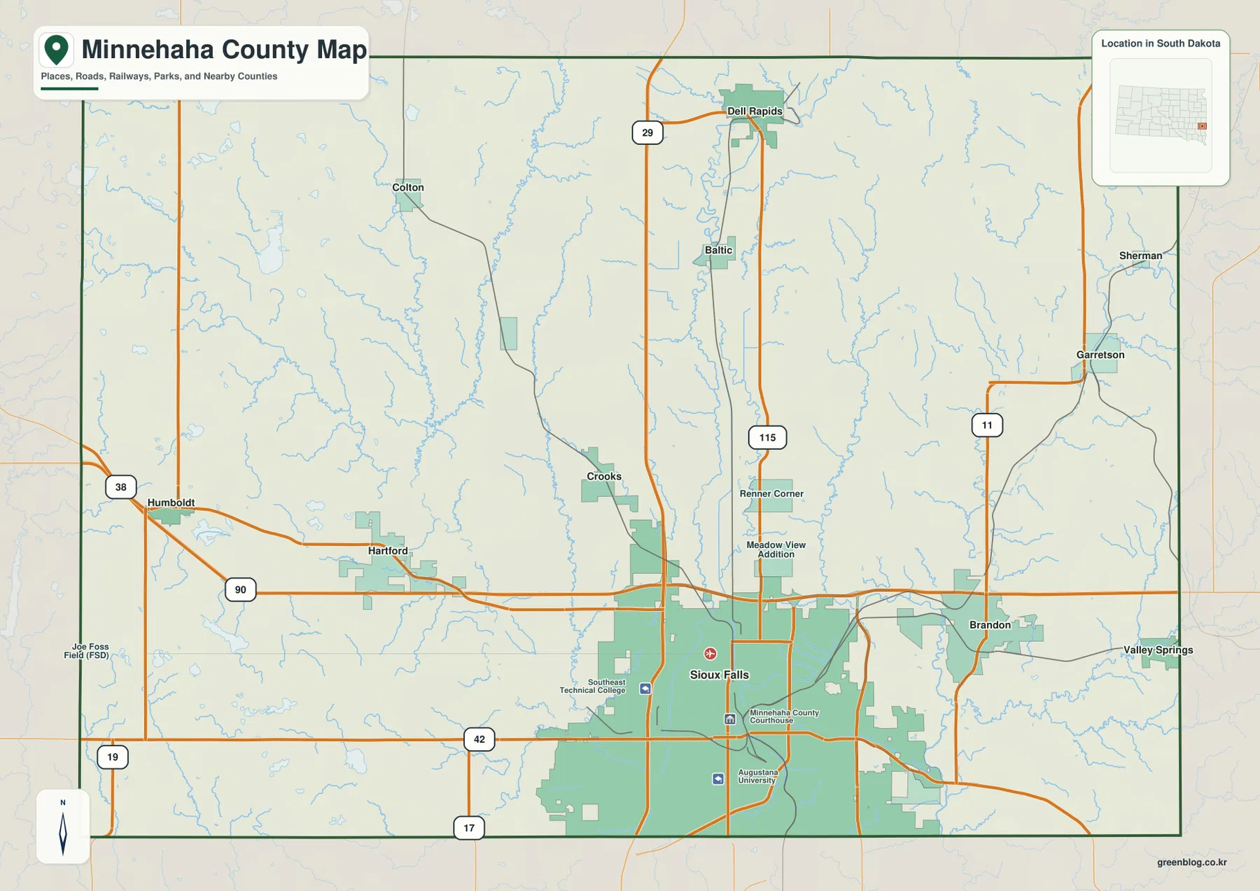
Water features are already visible on the general map. Big Sioux River passes through the central corridor, and tributaries become especially noticeable north of Sioux Falls and across the Brandon–Garretson side. Carrying those same positions over to the terrain-and-water map makes it easier to see how roads and settlements relate to the valleys rather than treating the road grid as the whole geography of the county.
The city map spreads six major places from Sioux Falls north to Dell Rapids
The city-distribution map places Sioux Falls at the large southern end of the county. Brandon and Hartford create a useful east-west comparison around it, while Crooks, Baltic, and Dell Rapids extend the mapped settlement pattern northward. The result is not a single straight chain of towns, but the I-29 corridor still provides a useful way to understand how the northern places relate to Sioux Falls.
No connector lines or mileage labels appear on this city map. The gaps between markers should therefore be read as relative position rather than measured distance. CITY INDEX numbers identify the mapped places and do not represent mileage, population rank, elevation, or travel sequence; actual straight-line and driving distances require a separate distance or routing source.
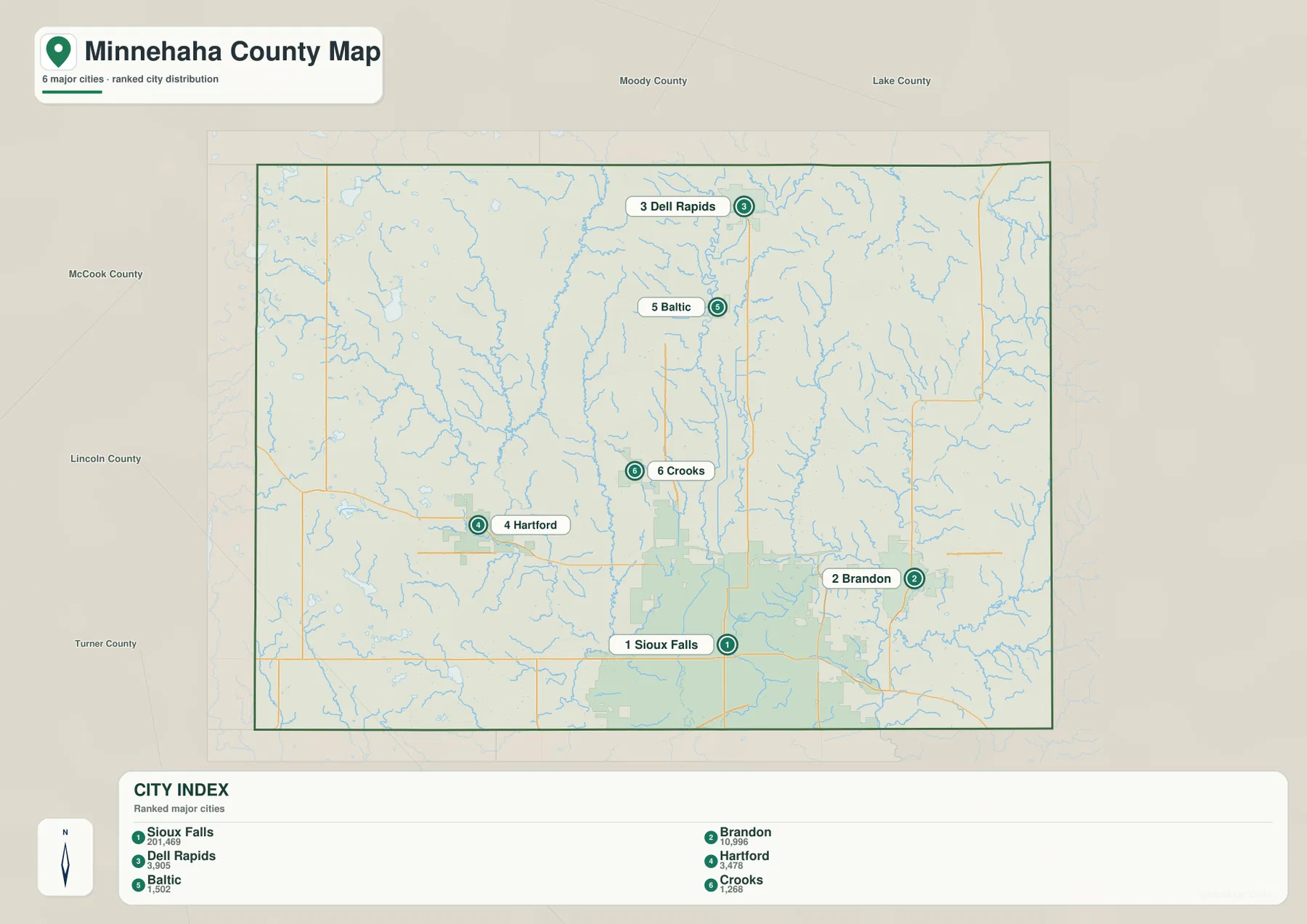
The city names become more informative when they are checked across the other layers. Dell Rapids is a useful northern reference on the Big Sioux corridor, Hartford helps locate the western creek country, and Brandon sits close to the eastern drainage network. That cross-check keeps the map discussion focused on place relationships rather than on lists of town names.
Big Sioux River, Skunk Creek, and Willow Creek divide the central and western terrain
Big Sioux River is the strongest continuous water feature on the terrain-and-water map. It runs south through the middle of the county and creates the central low corridor that passes the Sioux Falls area. West of it, Skunk Creek follows another long valley, while Willow Creek cuts through the southwest. Together, those three streams make the central and western drainage structure easy to recognize.
The east has a more branched pattern. Split Rock Creek is the main named reference near the Brandon and Garretson side, with smaller tributaries spreading across that part of the county. Western water bodies such as Wall Lake and Diamond Lake add a different type of feature, so the west combines upland creek valleys with scattered lakes rather than matching the eastern stream network exactly.
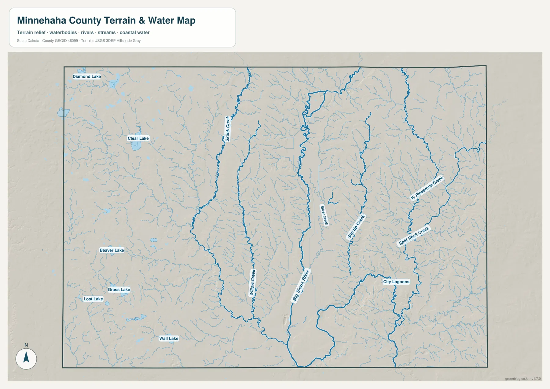
This water layer is a geographic reference for stream and lake names and positions. It does not show real-time flow, water depth, water quality, flood zones, or navigability, and a blue line should not be treated as a legal or parcel boundary. For current hydrographic source data, consult an authoritative dataset such as USGS National Hydrography.
Elevation ranges from about 345 to 555 m, with the west higher than the Big Sioux valley
The elevation legend gives an actual range of about 345 to 555 meters and a mean near 470 meters. Broad tan and brown areas cover much of the western half, while the Big Sioux River corridor is markedly greener and lower through the center. Lower stream-cut terrain also appears toward the southeast, producing a county-scale difference of roughly 210 meters between the listed minimum and maximum.
The western upland is interrupted by valleys rather than forming one uniform high surface. Skunk Creek and Willow Creek create lower strips through the higher colors, and smaller low pockets appear around western lakes. East of the Big Sioux River, ridges still rise between tributaries, so the map is best understood as a series of uplands separated by stream valleys rather than a simple west-to-east slope.
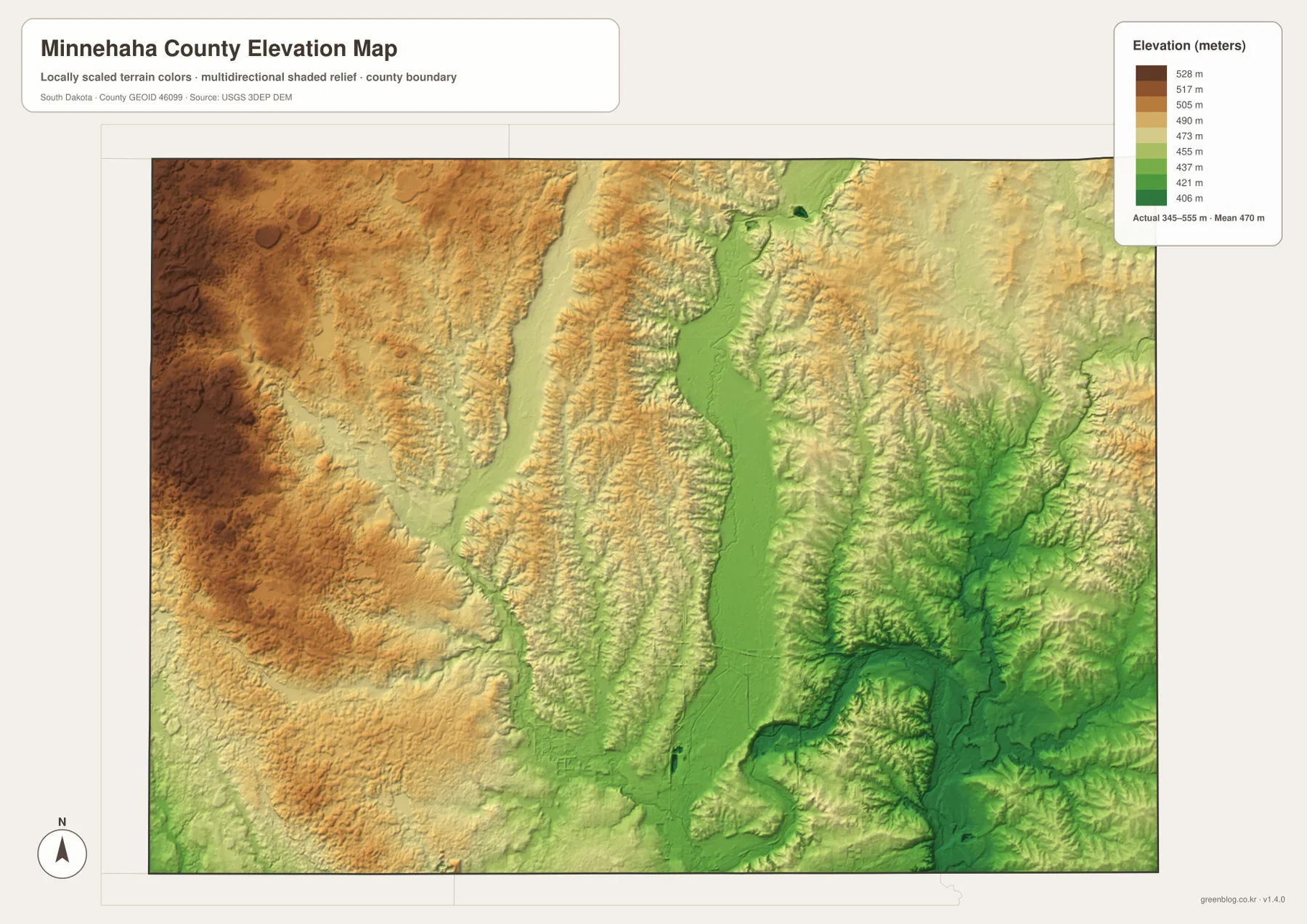
The elevation surface is intended for broad county comparison and is not a survey-grade measurement. An exact elevation for a road point, farm corner, building site, or engineering location should come from an official DEM source such as the USGS 3D Elevation Program or from an appropriate site survey.
Compare Brandon and Hartford to see the east-west difference
Brandon is a useful eastern reference because it lies east of Sioux Falls and close to the Split Rock Creek drainage. On the elevation map, lower stream corridors alternate with higher ridges, so the eastern side is more varied than a single flat lowland. Following Brandon across the general, water, and elevation maps shows how a city can sit close to both valley floors and higher nearby ground.
Hartford provides the western comparison. It is close to I-90 on the general map and lies nearer the Skunk Creek and Willow Creek region on the water map. The elevation layer shows broader high ground west of Hartford, interrupted by the lower creek valleys. Looking back and forth between Brandon and Hartford makes the county’s east-west differences easier to understand without reducing them to a list of directions.
The WebP images in the article are optimized for screen viewing. The download archive contains the corresponding original JPG files for the general county map, city-distribution map, terrain-and-water map, and elevation map. Each JPG is 3638 × 2572 pixels, which is better suited to A3 printing, presentations, classroom materials, and closer inspection of labels.
Frequently Asked Questions
Does the city map give a distance from Sioux Falls to Brandon or Dell Rapids?
No. The city-distribution map shows six major places but includes no connector lines or mileage labels. Use a separate routing or distance source when an actual straight-line or driving distance is required.
Which map best shows the Big Sioux River and Skunk Creek?
The terrain-and-water map is the clearest choice. Big Sioux River runs through the central corridor, while Skunk Creek and Willow Creek form long western channels. Several eastern tributaries and western lakes are labeled as well.
Can the 345–555 m elevation range be used as an exact property elevation?
No. Those figures describe the county-wide elevation range, while the colored surface is designed for broad terrain comparison. Use official DEM or survey data when an exact elevation is needed at a specific point.
Map File Information
The ZIP contains the original high-resolution JPG files for the Minnehaha County general map, city-distribution map, terrain and water map, and elevation map.
- Included Files: 4 JPG maps
- Printable Size: 3638 × 2572 px each
Related Maps
Sources and references
- U.S. Census Bureau TIGER/Line Shapefiles – official geographic source for county boundaries and base mapping data.
- USGS National Hydrography – official source for rivers, streams, lakes, and hydrographic data.
- USGS 3D Elevation Program – official source for elevation and DEM products.
Green Map creates custom-edited map images using open geographic data sources such as geoBoundaries, Natural Earth, OpenStreetMap, and government open data.
These maps are edited visual materials, not raw data files, and are provided for education, documents, presentations, and graphic reference.