You can download the original A3 high-resolution JPG map files for Hardin County from this page as one ZIP archive. To orient the county first, look at the cluster of communities in its eastern half: Kountze sits a little east of center, Silsbee lies farther east, and Lumberton is to the southeast, while Sour Lake is separated from that group in the southwest. The maps also show county roads, named creeks and bayous, and local elevation, so the downloadable files can be used for both place-finding and a broader view of the county landscape.
The physical map adds an important second layer. Hardin County is crossed by a dense network of waterways, including Village Creek, Pine Island Bayou, Little Pine Island Bayou, Big Sandy Creek, and Cypress Creek. The elevation map shows an actual range of about -2 to 50 meters with a mean near 22 meters. Higher ground is concentrated toward the northwest, while much of the east and southeast is lower. Looking at settlement, water, and relief together gives a much clearer picture than treating the county as a single flat block.
Table of Contents
Lumberton and Kountze Give the County Two Useful Anchors
The city-connections map uses Lumberton as the hub and places Silsbee, Kountze, Sour Lake, and Rose Hill Acres around it. Lumberton is in the southeastern part of the county. Silsbee is northeast of Lumberton, Kountze is northwest, and Rose Hill Acres is close to the southern county edge. Sour Lake stands apart to the southwest. That arrangement makes it clear that Hardin County does not have one compact settlement cluster covering the whole county; the eastern communities are relatively close to one another, while the southwest is more separated.
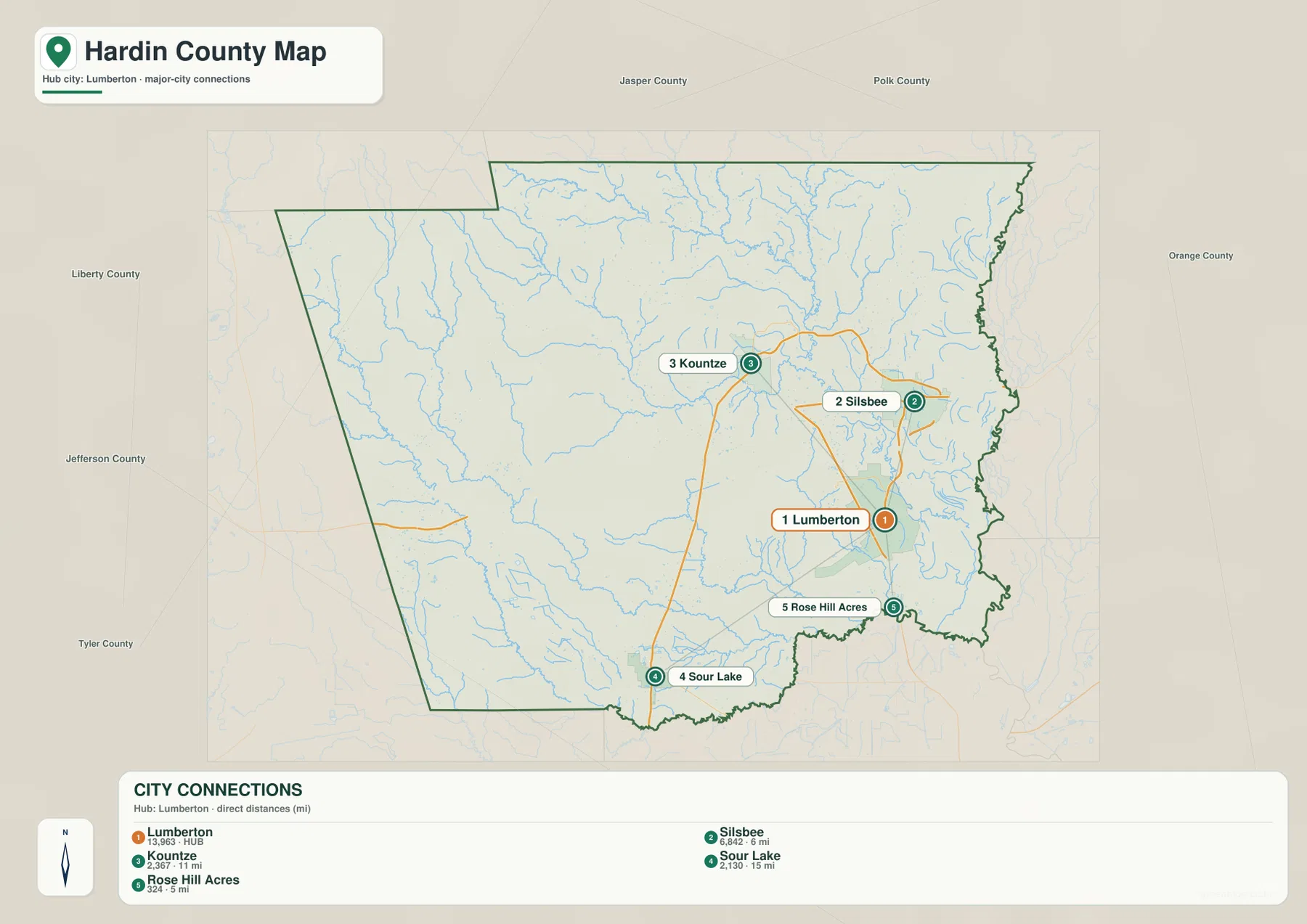
This city pattern is useful before looking at any road or water detail. Silsbee and Lumberton are close enough that their road connections form a visible eastern network, and Kountze is tied into the same half of the county. Sour Lake requires a different reference direction because it sits far from those three. If you begin with these four places, the rest of the maps become easier to orient: east is the denser community side, the southwest is more isolated, and the broad western interior contains far fewer labeled population centers on the provided city map.
U.S. 69/287 and State Routes Tie Together the Eastern Communities
The general county map makes the road pattern especially clear around Kountze, Silsbee, and Lumberton. U.S. route labels 287 and 69 follow the north-south corridor through Kountze and Lumberton. State Highway 418 runs east from the Kountze area toward Silsbee, while 327 and 96F are shown around the Silsbee side of the county. Route 96 appears along the eastern edge. These roads form a more connected network than the sparse western half of the county, matching the closer spacing of the major communities on the city map.
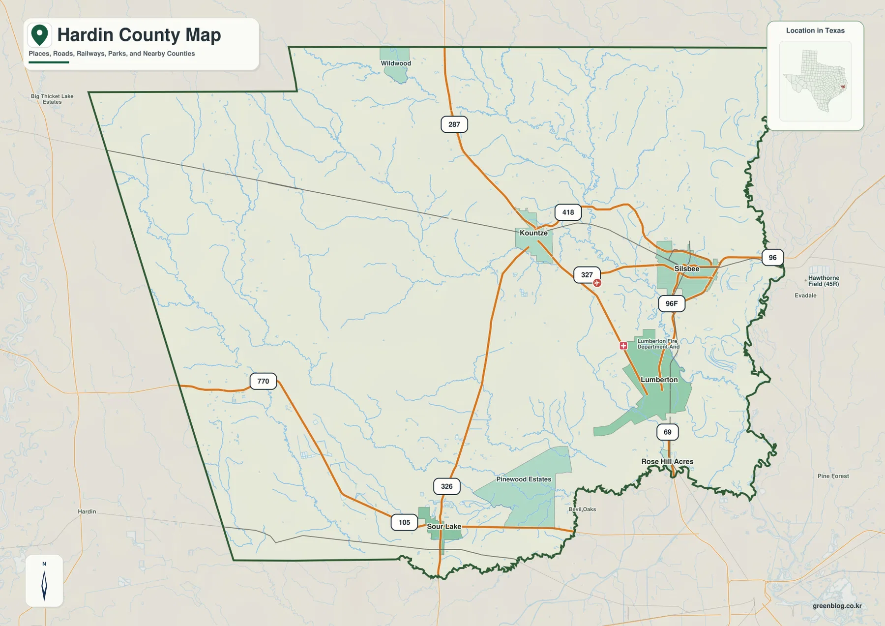
Roads around Sour Lake form a different pattern. The map shows 105 and 326 near the community, with 770 farther west. This gives the southwestern part of Hardin County its own set of travel lines rather than simply extending the Kountze-Silsbee network. Numerous small streams are visible beneath the road layer, which helps explain why the road system is not a perfect rectangular grid. The map is useful for county-scale orientation, but current driving conditions, closures, and access should always be checked with up-to-date transportation information.
Village Creek and Pine Island Bayou Reveal a Dense Water Network
The terrain-and-water map is one of the most distinctive views in the package because named streams cover nearly every part of the county. Village Creek runs through the eastern side and is joined by or closely associated on the map with smaller waterways such as Mill Creek and Dry Creek. Big Sandy Creek crosses the north, while Beaumont Creek winds through the north-central area. These channels make the eastern half look much more dissected than it does on a simple road map.
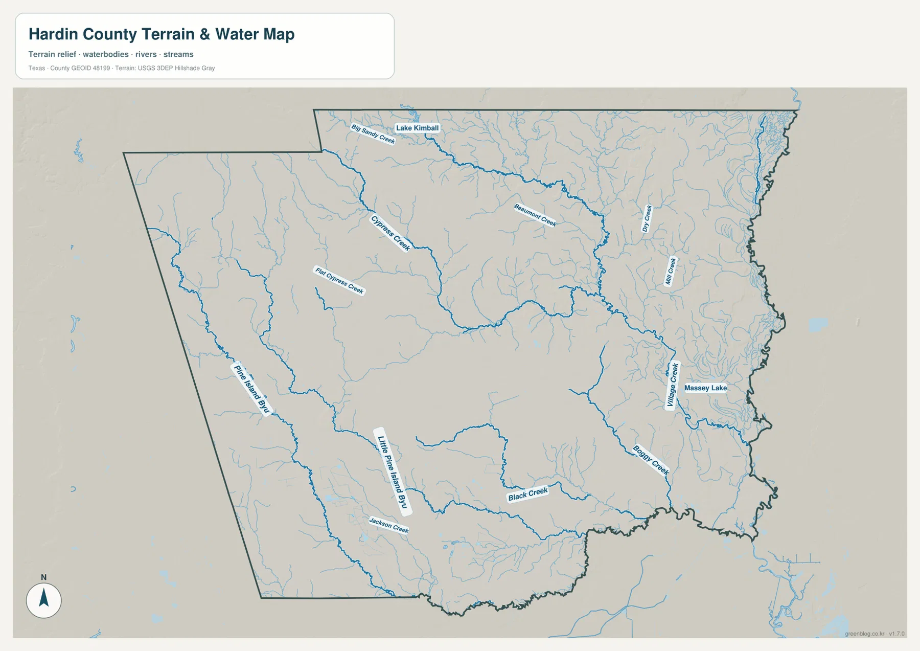
The western and southern parts are also crossed by named waterways. Cypress Creek and Flat Cypress Creek appear in the west. Pine Island Bayou and Little Pine Island Bayou extend through the southwest and south, with Jackson Creek and Black Creek nearby. Boggy Creek is labeled in the southeast. Lake Kimball is shown near the north, and Massey Lake appears near the eastern side. The result is not a county organized around one river but a landscape divided by many creeks, bayous, and low corridors. Comparing these names with the city map helps show which waterways lie between the eastern communities and the more open western interior.
Low Overall Elevation Still Produces a Clear Northwest-to-East Contrast
The elevation map lists an actual county range of about -2 to 50 meters and a mean elevation of roughly 22 meters. Those numbers are low compared with many inland Texas counties, yet the shaded relief still shows meaningful local differences. Brown and tan tones cover much of the northwest, indicating relatively higher ground. Greens become more common toward the center, east, and southeast, where the land is lower. The change is gradual across broad areas but becomes sharper along stream valleys.
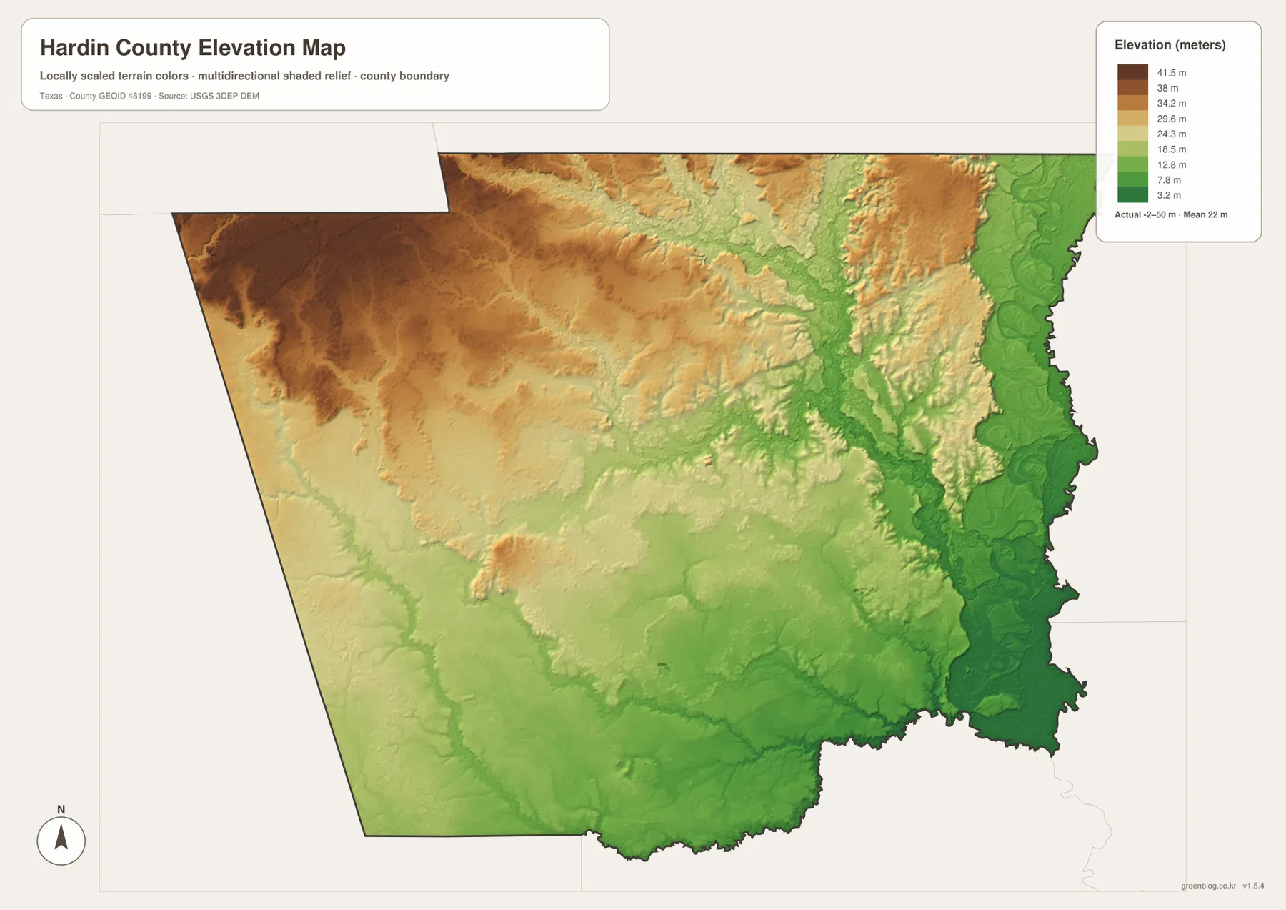
Village Creek is especially useful as a comparison point because a long, low corridor follows its general path in the eastern half of the elevation image. Other creeks also appear as narrow cuts through higher surrounding ground. The southeast corner is broadly low, while the northwest retains the largest continuous area of higher terrain. This map is intended for understanding county-scale relief; it should not be used as a substitute for surveyed elevations, parcel-level engineering, flood determinations, or site-specific safety information.
Neighboring Counties Help Place Hardin County in Southeast Texas
The city map labels Jasper County and Polk County to the north, Orange County to the east, Jefferson County to the southwest, and Tyler County to the west. Those names are useful because Hardin County’s roads and waterways do not stop at the administrative boundary. Lumberton sits near the southern side of the county, Silsbee is closer to the east, and Sour Lake is oriented toward the southwest. The surrounding county labels therefore provide a quick regional frame even before opening a statewide map.
The boundary itself is easiest to see on the general county map, but the physical maps explain why the county does not feel uniform inside that line. The eastern side combines more communities, more obvious road connections, a dense creek network, and generally lower terrain. The northwest is higher and has fewer labeled cities on the supplied city map. The southwest is anchored by Sour Lake and a separate set of roads and bayous. Putting those pieces together gives the county a much more specific shape than a generic southeast Texas description would provide.
Choose the Map by the Question You Need to Answer
Use the city-connections map when the main goal is to compare Lumberton, Silsbee, Kountze, Sour Lake, and Rose Hill Acres. The general county map is better for route numbers, community placement, and the county boundary in one view. The water map is the best choice for named features such as Village Creek, Pine Island Bayou, Big Sandy Creek, or Cypress Creek. The elevation map is most useful when you want to compare the higher northwest with the lower east and southeast. Switching between the same location on several maps is often more informative than trying to make one image answer every question.
The WebP images in the article are optimized for viewing on the page. For printing, classroom work, offline reference, or projects that need a larger image, the downloadable files are more suitable. The ZIP contains the county map, city map, water map, and elevation map as four original A3 high-resolution JPG files. You can keep the complete set or extract only the map needed for a particular task.
Frequently Asked Questions
Which places are the best starting points on the Hardin County map?
Kountze and Lumberton make useful first anchors. Kountze is a little east of the county center and Lumberton is in the southeast, with Silsbee to the east-northeast of Lumberton. Adding Sour Lake in the southwest makes the county’s full east-west spread much easier to judge.
Which waterways stand out most on the Hardin County water map?
Village Creek is a strong eastern reference, while Pine Island Bayou and Little Pine Island Bayou are prominent in the southern half. Big Sandy Creek in the north and Cypress Creek with Flat Cypress Creek in the west provide additional anchors. Many smaller tributaries fill the spaces between them.
What does the elevation map show about Hardin County?
The supplied legend gives an actual range of about -2 to 50 meters with a mean near 22 meters. The northwest is generally higher, while the east, southeast, and many stream corridors are lower, so the relief map pairs especially well with the water map.
References and Official Data
County boundaries and base geography can be checked with U.S. Census Bureau TIGER/Line Shapefiles. Named streams and hydrography are available through USGS National Hydrography, while elevation data are documented by the USGS 3D Elevation Program. For a combined interactive geographic view, see USGS The National Map Viewer.
Map File Information
Download the four original A3 high-resolution JPG files used on this Hardin County page in one ZIP archive.
- File Type: JPG
Related Maps
- Orange County Texas map
- Polk County Texas map
- Tyler County Texas map
- Angelina County Texas map
- Sabine County Texas map
Green Map creates custom-edited map images using open geographic data sources such as geoBoundaries, Natural Earth, OpenStreetMap, and government open data.
These maps are edited visual materials, not raw data files, and are provided for education, documents, presentations, and graphic reference.