Ashe County sits in the mountain country of northwestern North Carolina, and its map is easiest to understand by starting near Jefferson and West Jefferson before following the roads and rivers outward. This page includes a county map with major routes and place names, a city-connection map centered on Jefferson, and a terrain-and-water map that traces the New River system across the county. After reviewing the maps, you can download a ZIP containing three high-resolution A3 JPG files for printing or offline use.
The three supplied maps are useful for different questions. The general county view emphasizes roads such as US 221 and several numbered North Carolina routes. The city view strips the map down to Jefferson, West Jefferson, and Lansing so their positions are easier to compare. The water view changes the emphasis again, showing the North Fork and South Fork of the New River with a dense network of mountain creeks laid over shaded terrain. Moving between those views gives a much clearer picture of Ashe County than repeating the same labels on every map.
Table of Contents
Roads spreading out from Jefferson and West Jefferson
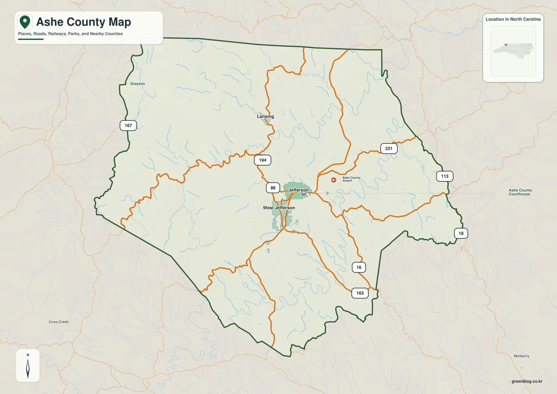
Jefferson and West Jefferson form the most obvious paired reference on the county map. They are close together near the central part of the county, yet the surrounding route labels make it possible to follow different directions from that core. NC 88 crosses the area near Jefferson, while NC 194 runs north toward Lansing. US 221 approaches from the northeast and links into the road network east of Jefferson. Farther south, NC 16 continues toward the lower part of the county, and the map also marks NC 113 and NC 18 along the eastern side.
Other route numbers help fill in the outer edges. A 167 shield appears near the western boundary, while 163 is shown in the southeast. The road lines bend repeatedly rather than forming a simple grid, which fits the rugged relief shown more clearly on the terrain map. For a reader trying to orient a trip, compare communities, or understand why several routes converge near Jefferson, this county view is more useful than a terrain-only map because the road labels remain easy to see.
Why Lansing changes the way the county layout looks
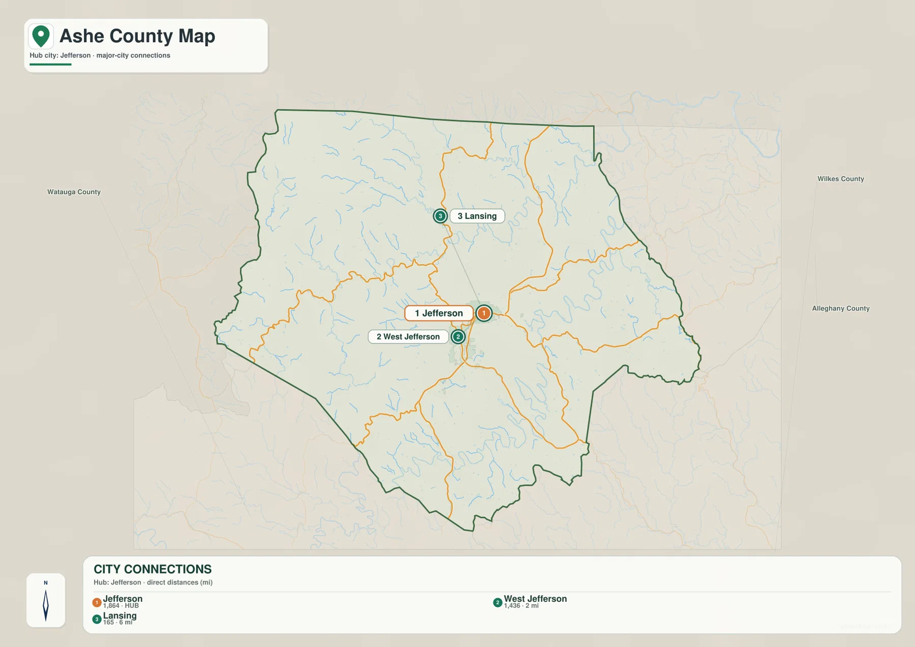
The city-connection map reduces the number of labels and makes the separation among the three highlighted communities much easier to see. Jefferson and West Jefferson sit close together near the center, while Lansing is distinctly farther north. That spacing matters because a map focused only on the county seat could make the northern half of Ashe County feel secondary. Adding Lansing provides a clear northern reference and helps the viewer judge how far the mapped county extends beyond the Jefferson–West Jefferson area.
The same map labels neighboring counties outside the Ashe County boundary. Watauga County appears to the west, Wilkes County to the east, and Alleghany County toward the northeast. Those surrounding names give useful directional context without crowding the interior with extra detail. A viewer can quickly tell that travel toward the eastern edge points toward Wilkes County, while the western side faces Watauga County. Lansing, meanwhile, sits much closer to the northern portion of the county than the two Jefferson communities.
The New River forks and a web of mountain creeks
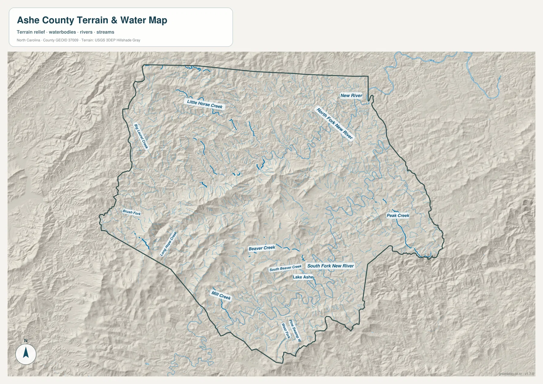
The terrain-and-water map tells a different story from the road map. In the northeastern part of Ashe County, the North Fork New River winds through a broad set of small tributaries before continuing toward the New River label near the upper-right edge. The South Fork New River runs through the southern and eastern part of the county. Seeing the two forks separately makes it easier to understand that the county’s drainage is not represented by one single river line; water reaches those forks through many smaller valleys.
Several named tributaries provide useful local landmarks. Little Horse Creek appears in the northwest, with Big Laurel Creek along the western side. Brush Fork and Long Hope Creek are marked in the southwest. Near the center-south, Beaver Creek and South Beaver Creek feed the wider network, while Mill Creek is labeled farther south and Peak Creek is shown in the east. Lake Ashe is also marked near the South Fork New River. These names make the water map especially useful when a general county map does not provide enough detail about streams and valleys.
How the shaded terrain helps explain the waterways
The gray relief on the water map is not just decorative. Ridges and narrow valleys repeat across nearly the entire county, and the blue stream lines tend to follow the lower ground between them. Around the North Fork New River, the river bends again and again as smaller tributaries enter from neighboring slopes. The South Fork and its tributaries show a similar relationship in the lower half of the county. Without the shaded relief, those curves could look random; with the terrain visible, their connection to the mountain valleys is much easier to recognize.
This is also why the route map and water map should not be treated as interchangeable. The road map answers practical location questions: where Jefferson sits, which direction US 221 runs, or how NC 194 reaches Lansing. The terrain map is better when the question concerns river forks, stream valleys, or the shape of the mountain ground. A user planning a presentation might use the first map to introduce the county and then switch to the water map when discussing physical geography.
Choosing the right Ashe County map for the task
Use the general county map when boundaries, road numbers, and multiple place names need to appear together. It gives the clearest overview of how Jefferson and West Jefferson connect to Lansing and to the eastern and southern parts of the county. Use the city-connection map when the main goal is to compare only the three highlighted communities without as many competing labels. Its simpler layout makes the Jefferson–West Jefferson cluster and the separate northern position of Lansing immediately apparent.
The terrain-and-water map is the strongest choice for rivers, creeks, and mountain relief. It is the only supplied view that labels both forks of the New River together with smaller streams such as Little Horse Creek, Beaver Creek, and Peak Creek. Because the page previews are optimized for viewing on the web, the downloadable JPG files are better when you need a larger printed map, want to place a map into a document, or need to inspect labels at a bigger scale.
A practical sequence for reading the three maps together
A useful sequence begins with Jefferson on the county map. From there, follow NC 194 north toward Lansing and US 221 toward the northeast, then note the positions of NC 16, NC 18, NC 88, and NC 113. Next, open the city map and compare how much of the county lies beyond the tight Jefferson–West Jefferson pair. Finally, move to the terrain map and locate the North Fork New River, South Fork New River, and the named creeks around them. That progression moves from human travel routes to settlement spacing and then to the mountain water system.
The maps can also be used in the opposite direction. If a stream name is your starting point, first find it on the terrain map and note which part of the county it occupies. Then return to the road map to see which major route or community lies nearby. This method is particularly helpful in Ashe County because many blue stream lines occupy valleys that are visually separate from the orange road network. The two layers describe the same county, but they emphasize very different features.
Frequently Asked Questions
Which map is best for comparing Jefferson, West Jefferson, and Lansing?
The city-connection map is the quickest choice because it isolates those three places and makes their spacing easy to compare. Jefferson and West Jefferson appear close together in the central part of the county, while Lansing is clearly farther north. If you also need route numbers or more boundary detail, follow it with the general county map.
Why are the North Fork and South Fork New River worth viewing separately?
The water map shows the forks occupying different parts of Ashe County and receiving different groups of tributaries. The North Fork is prominent in the northeast, while the South Fork crosses the lower and eastern part of the map near streams such as Beaver Creek and the Lake Ashe label. Separating the forks makes the county’s river network much easier to follow than treating the New River as one undivided line.
Sources and reference data
These official resources provide county information and the boundary, hydrography, and elevation data categories used to support the map workflow.
- Ashe County official county information
- U.S. Census Bureau TIGER/Line boundary data
- USGS National Hydrography
- USGS 3D Elevation Program
Map File Information
The download ZIP contains three high-resolution A3 JPG files for Ashe County: a county road-and-place map, a Jefferson-centered city map, and a terrain-and-water map.
- Included Files: Use only the versions confirmed in the article and supplied images
- File Type: Use the confirmed download contents
- Intended Use: Printing, education, presentations, and map-based projects
Related Maps
Green Map creates custom-edited map images using open geographic data sources such as geoBoundaries, Natural Earth, OpenStreetMap, and government open data.
These maps are edited visual materials, not raw data files, and are provided for education, documents, presentations, and graphic reference.