Oneida County in southeastern Idaho combines the Malad City valley with broad mountain country, branching streams, and several named reservoirs. This Oneida County Idaho Map page brings those pieces together through a county-and-roads map, a city distribution map, a water-and-terrain map, and an elevation map. High-resolution JPG versions of all four maps are also available in the download box near the end of the page.
The county has a strong east-to-west contrast. Malad City and the main north-south highway sit toward the eastern side, while a much larger area extends westward through ridges, valleys, and smaller drainage lines. Looking at the four maps together makes it easier to see how roads follow the lower ground, where named reservoirs sit among the hills, and how sharply elevation changes across the county.
Table of Contents
Roads and county shape around Malad City
The general county map places Malad City near the eastern side of Oneida County. I-15 runs north and south near the city, while ID-38 stretches west across the county. ID-36 is shown near the eastern boundary. Together, those routes make Malad City the clearest road junction on the map even though the county itself extends far beyond the city in several directions.
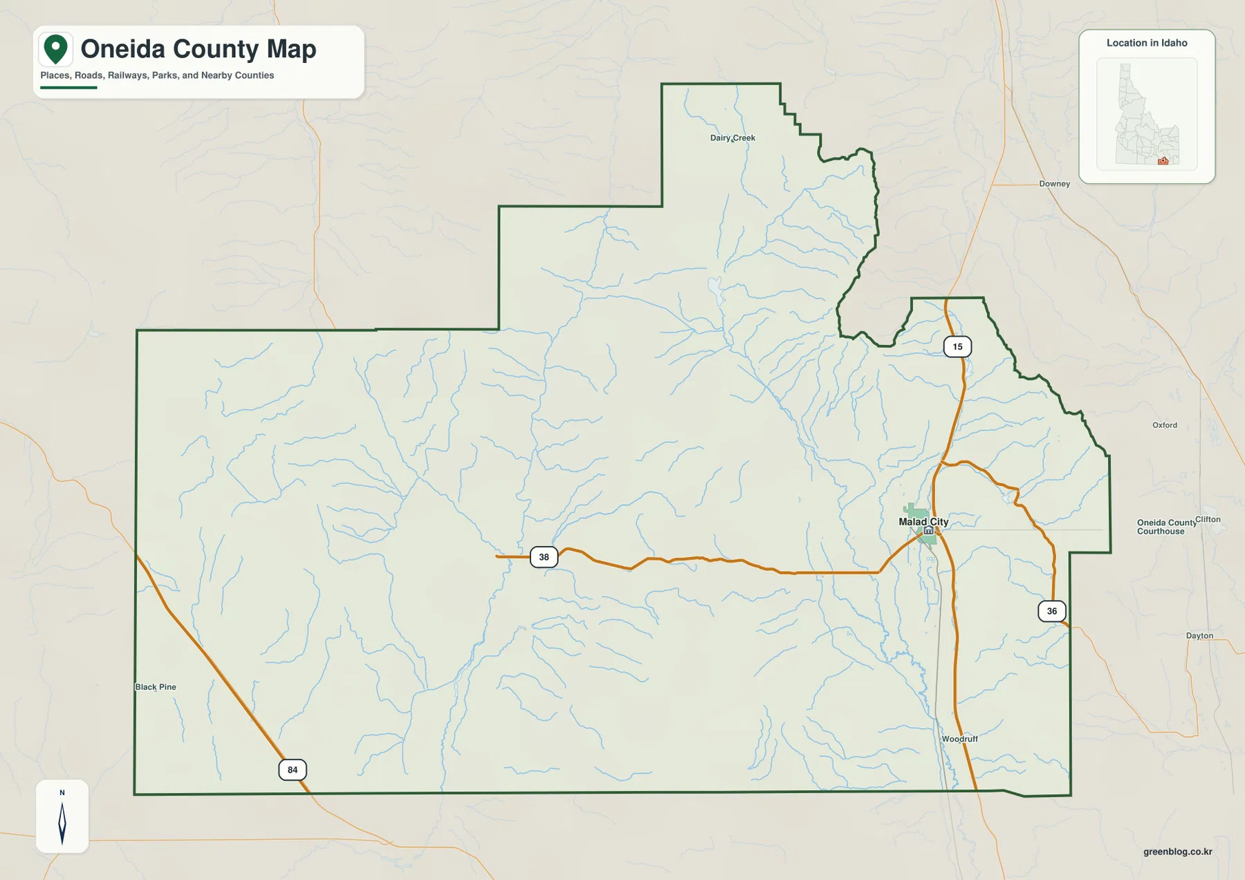
The outline is not a simple rectangle. The northern part steps outward and inward several times, and the eastern edge also changes direction before reaching the long southern boundary. Much of the western half has few settlement labels, but it contains a dense pattern of small stream lines and relief features. That contrast helps explain why the map feels much more open west of Malad City even though there is still a great deal of terrain detail.
The city map adds neighboring county labels that help with regional orientation. Cassia County lies to the west, Power County and Bannock County are shown to the north and northeast, and Franklin County is on the eastern side. The map is useful for understanding location and general road relationships, but it is not a parcel, ownership, or legal survey map. For authoritative boundary work, readers should use official county records or Census TIGER/Line data.
A city map centered on Malad City
The city-distribution map is unusually simple because its major-city index contains only Malad City. The index shows a value of 2,601 next to the city name. That number should be treated as the value used for this map rather than as a promise of the latest official population count, since current population figures should be checked against a current statistical source.
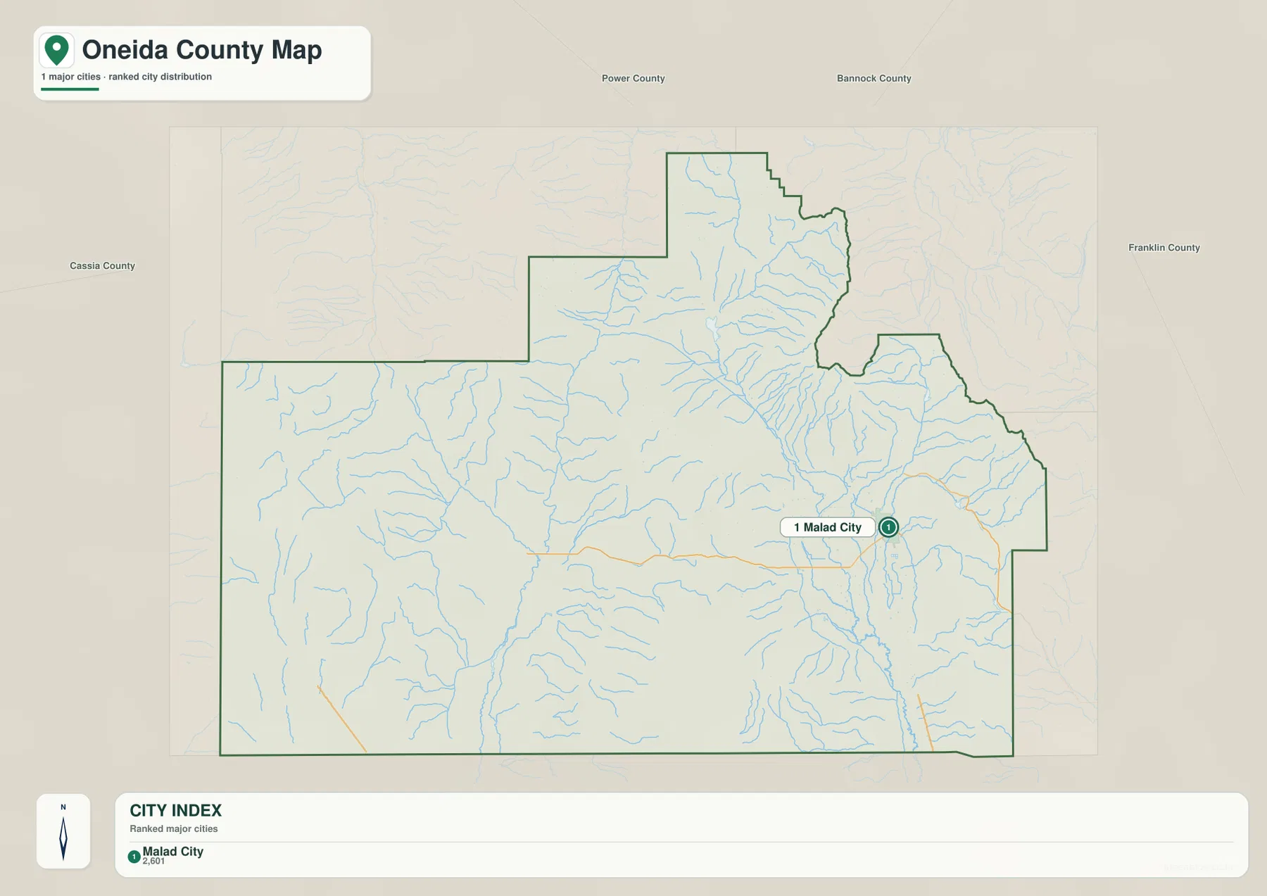
Malad City sits well east of the county’s geographic spread rather than at the center of the broad western area. That makes this map useful for a different reason than city maps with several ranked places. Instead of comparing multiple urban centers, it shows how one main labeled city relates to a large county that continues west and north through less settled terrain.
There are no connector lines or straight-line distance values on this city map because there is only one city in the selected major-city index. Readers should not interpret that as meaning that no other communities exist in the county. It only describes the contents of this particular map. For driving distance or travel time, a current road-navigation service is more appropriate.
Malad River, Little Malad River, and a chain of reservoirs
The water-and-terrain map reveals much more detail than the city map. Malad River and Little Malad River stand out on the eastern side, with Devil Creek and many smaller tributaries descending from nearby ridges. The shaded relief makes the connection between water and landform easy to see because many of the streams occupy lower troughs between higher ridges.
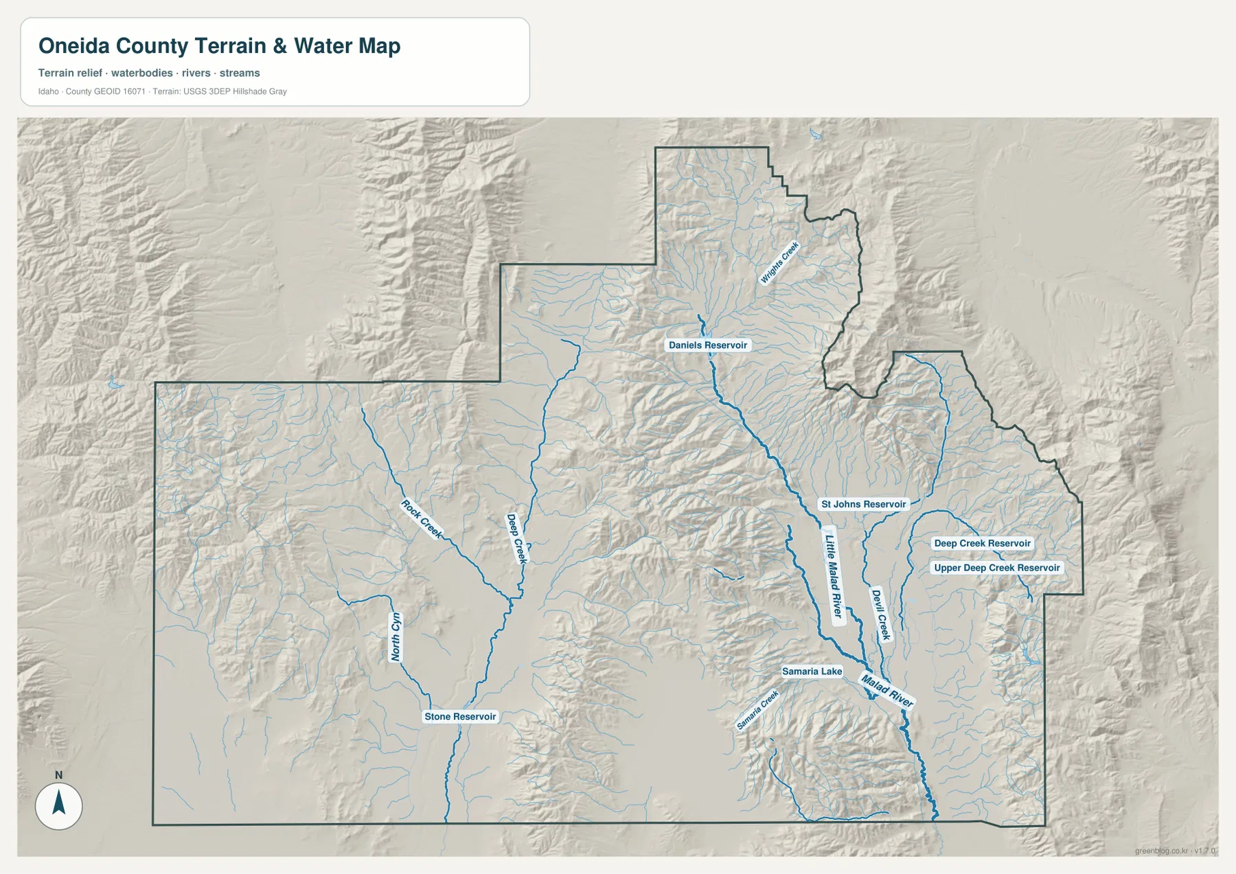
Daniels Reservoir is labeled in the northern part of the county, with Wrights Creek farther to the northeast. St Johns Reservoir appears east of center, while Deep Creek Reservoir and Upper Deep Creek Reservoir sit closer to the eastern edge. Farther west and south, the map also labels Deep Creek, Rock Creek, Birch Creek, Stone Reservoir, Samaria Creek, and Samaria Lake.
These features show that Oneida County’s water network is spread across several valleys rather than concentrated along one large river corridor. Smaller creeks descend from different directions before joining larger channels or ending near reservoirs. This map is intended for geographic reference, not for flood-risk analysis, water rights, water quality, reservoir operations, or navigation decisions.
From about 1,331 meters to 2,813 meters in elevation
The elevation map gives the clearest picture of how rugged Oneida County can be. Its stated actual range is about 1,331 to 2,813 meters, with a mean elevation of about 1,681 meters. Lower ground appears in green, especially across the Malad City and Malad River valley area and in several broad interior valleys. Higher ridges shift through yellow and brown tones.
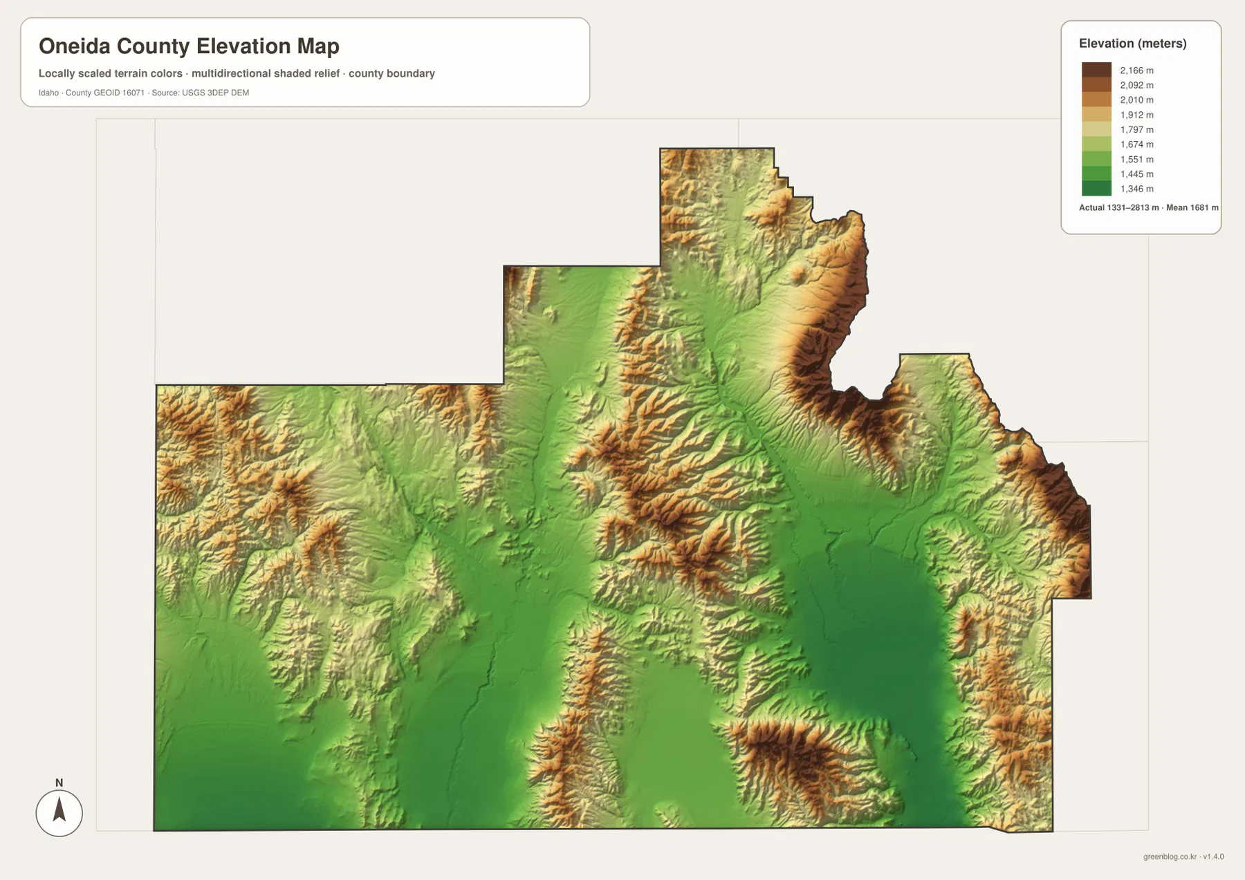
The eastern edge includes prominent high ground, but elevated ridges also appear in the north, west, and south-central parts of the county. Between them are lower corridors that form a patchwork of valleys rather than one continuous flat basin. Comparing this map with the water map shows why so many named creeks follow narrow paths between ridges before reaching the larger river system.
This elevation surface is designed for county-scale comparison. It should not be used to determine the exact elevation of a building site, calculate a road grade, perform engineering design, or replace a field survey. More precise work should begin with the original USGS elevation data or other survey-grade sources.
What the four maps show when viewed together
The road map and elevation map make a useful pair around Malad City. The city lies in relatively low terrain, I-15 follows the north-south side of that lower area, and ID-38 heads west through a corridor between higher ridges. A route that looks like a simple line on the road map becomes easier to understand once the surrounding relief is visible.
The water map adds another layer to the same landscape. Malad River and Little Malad River occupy the lower eastern valleys, while smaller streams descend from the mountain blocks to the north and west. Reservoirs such as Daniels Reservoir and Deep Creek Reservoir sit in different parts of that network, showing that water features are distributed across the county rather than clustered only near Malad City.
The city map, meanwhile, emphasizes how much of Oneida County lies outside the main labeled urban center. With Malad City as the only place in the major-city index, the broad western and northern areas are better understood through terrain, water, and road information than through city labels. That is why using the maps as a set is more informative than relying on only one layer.
Choosing the right Oneida County map
Use the general map when you want the county outline, Malad City, and the main roads on one page. The city map is the quickest way to see where Malad City sits within the county and relative to nearby counties. The water map is best for locating named rivers, creeks, reservoirs, and Samaria Lake, while the elevation map is the most direct choice for comparing low valleys with the surrounding high ridges.
- County boundary and roads: compare Malad City with I-15, ID-38, ID-36, streams, and the full county outline.
- City location: see Malad City as the single place in the selected major-city index and compare its position with neighboring counties.
- Water features: locate Malad River, Little Malad River, Daniels Reservoir, St Johns Reservoir, Deep Creek Reservoir, and other named waters.
- Elevation: compare terrain from roughly 1,331 meters in the lower areas to 2,813 meters at the highest mapped elevations.
The WebP images on the page are optimized for convenient online viewing. For printing, classroom use, local reference, or a larger image in a presentation, the downloadable archive contains the original high-resolution JPG versions. You can use a single map for a focused task or compare all four when you need roads, settlement, water, and terrain in the same county study.
Frequently Asked Questions
Why does the city map show only Malad City?
The provided city map contains one place in its selected major-city index: Malad City. That is why there are no connector lines or city-to-city distance labels. It does not mean that there are no other communities in Oneida County; it only describes the places included in this map’s major-city index.
Which reservoirs are labeled on the water map?
The map labels Daniels Reservoir, St Johns Reservoir, Deep Creek Reservoir, Upper Deep Creek Reservoir, and Stone Reservoir. Samaria Lake is also labeled in the southern part of the county. Because shaded relief is shown underneath the water features, it is easy to compare each reservoir with the surrounding valley and ridge terrain.
How large is the elevation range shown for Oneida County?
The elevation map states an actual range of about 1,331 to 2,813 meters and a mean of about 1,681 meters. The colors are intended for county-scale comparison, so they are useful for seeing low valleys and high ridges but should not replace detailed surveying or engineering data.
Map File Information
The archive contains high-resolution JPG versions of the Oneida County general map, city map, water map, and elevation map.
- Included Files: Use only the versions confirmed in the article and supplied images
- File Type: Use the confirmed download contents
- Intended Use: Printing, education, presentations, and map-based projects
Related Maps
Sources and references
- Idaho Secretary of State – County Clerks – state government listing for Oneida County administrative contact information in Malad
- U.S. Census Bureau TIGER/Line Shapefiles – county boundary, road, and geographic reference data
- USGS National Hydrography – river, stream, reservoir, and other hydrography data
- USGS 3D Elevation Program – elevation and terrain data
Green Map creates custom-edited map images using open geographic data sources such as geoBoundaries, Natural Earth, OpenStreetMap, and government open data.
These maps are edited visual materials, not raw data files, and are provided for education, documents, presentations, and graphic reference.