Owyhee County covers a broad part of southwestern Idaho, with its most visible towns close to the lower northern edge and a much larger expanse of high desert, river valleys, and mountain terrain to the south. This Owyhee County Map page combines four views: county boundaries and roads, city connections, water and terrain, and elevation. High-resolution JPG versions of the same four maps are available in one ZIP download near the end of the page.
The county changes character quickly as you move away from the Snake River. Homedale and Marsing sit close together in the northwest, while Murphy lies farther inland and Grand View is much farther east along the northern side. On the water map, the Snake River defines much of the upper edge, but the interior is divided among the Owyhee, Bruneau, and Jarbidge river systems. The elevation map adds another layer, showing low ground near the north and much higher country across the south and southwest.
Table of Contents
Roads from Homedale and Marsing into a very large county
The general county map puts Homedale and Marsing in the northwest corner, where roads, streams, and nearby settlements are packed into a relatively small area. US 95 runs near the western side, Route 201 reaches the Homedale area, and Route 78 continues southeast through Murphy toward Grand View. Route 51 then extends south through the interior toward the southern edge. These routes make the northern third of the map easier to read than the much more open southern half.
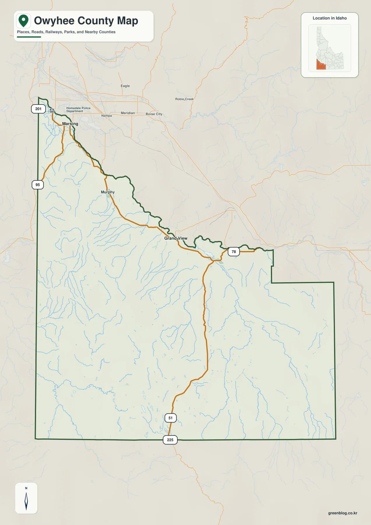
The northern boundary is irregular because it follows the Snake River through long bends rather than a single straight line. South of that river edge, the county opens into a large interior with fewer town labels and many more small drainage lines. The contrast is useful when orienting yourself: the northwest is where the named towns and road network are most concentrated, while much of the southern area is better understood through its valleys, rivers, and relief.
Murphy appears southeast of Homedale along Route 78, and Grand View is farther east near the Snake River side of the county. The map is intended for general geographic reference, not for parcel boundaries, land ownership, legal surveys, or route engineering. Readers who need authoritative legal boundaries should consult official county records or Census TIGER/Line data.
Homedale as the hub for Marsing and Grand View
The city-connections map uses Homedale as its hub. Marsing is labeled about 8 miles away, while Grand View is shown about 61 miles from Homedale. Those numbers are straight-line distances drawn for geographic comparison. They are not driving distances, and actual road mileage can be longer because routes must follow the river corridor, bridges, and the available road network.
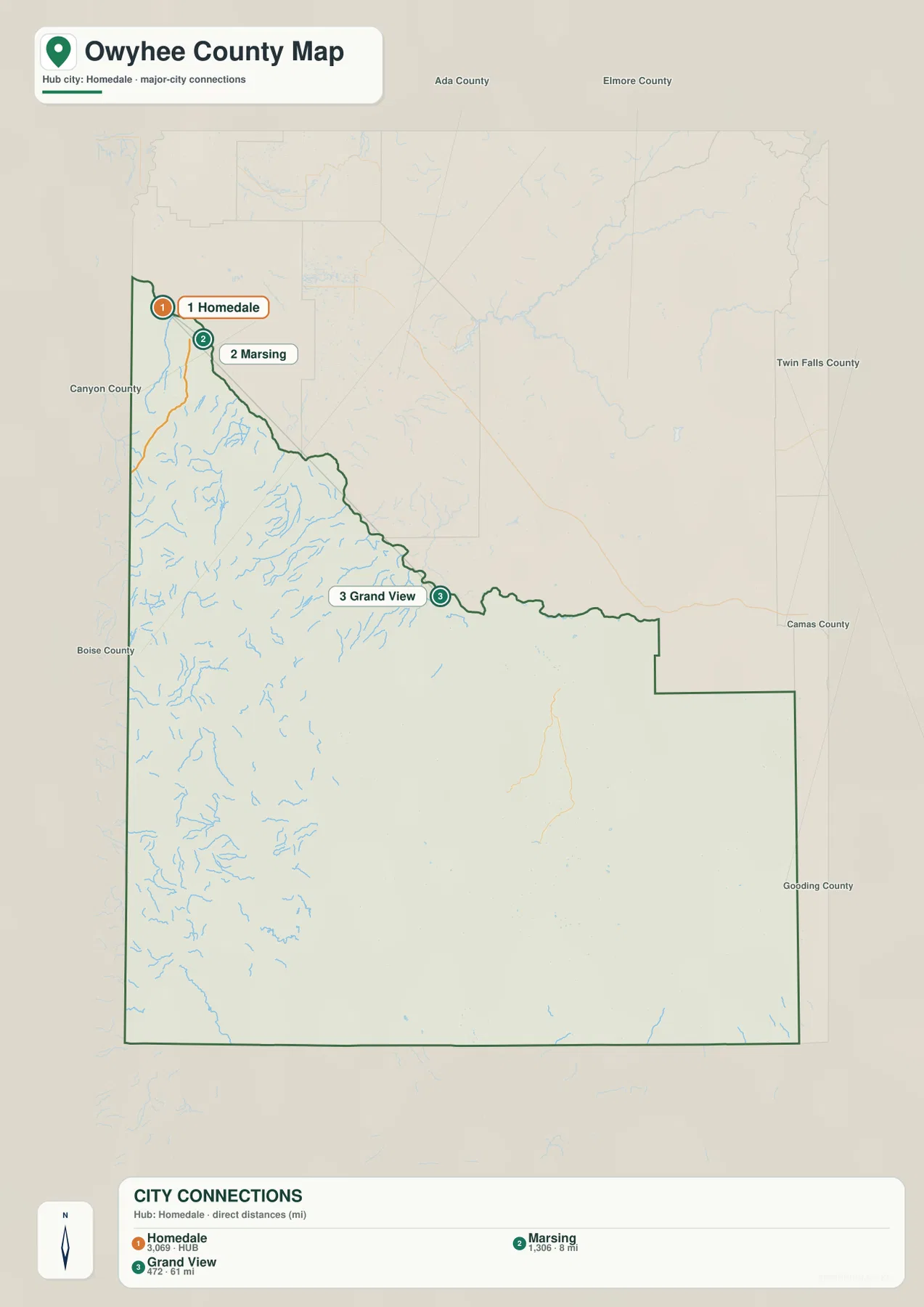
The arrangement of the three labeled cities is more informative than the count itself. Homedale and Marsing sit close together in the northwest, while Grand View is separated from them by a long stretch of the county’s northern side. Most of the central and southern county has no comparable city markers on this map, reinforcing how concentrated the selected urban points are near the Snake River side.
The map also labels neighboring counties around Owyhee County, which helps place the city cluster in a wider regional setting. The selected city list should not be treated as a complete inventory of every community or settlement. For current population figures, road travel times, or navigation, use current statistical and routing sources rather than the straight-line city graphic.
Snake River on the north, Owyhee River in the west, Bruneau and Jarbidge in the east
The water-and-terrain map makes the county’s internal geography much clearer. Snake River follows the northern edge, while Owyhee River and South Fork Owyhee River occupy the southwestern side. Farther east, Bruneau River and Jarbidge River cut through a separate set of valleys. Clover Creek and Big Draw add smaller named channels to the eastern part of the map.
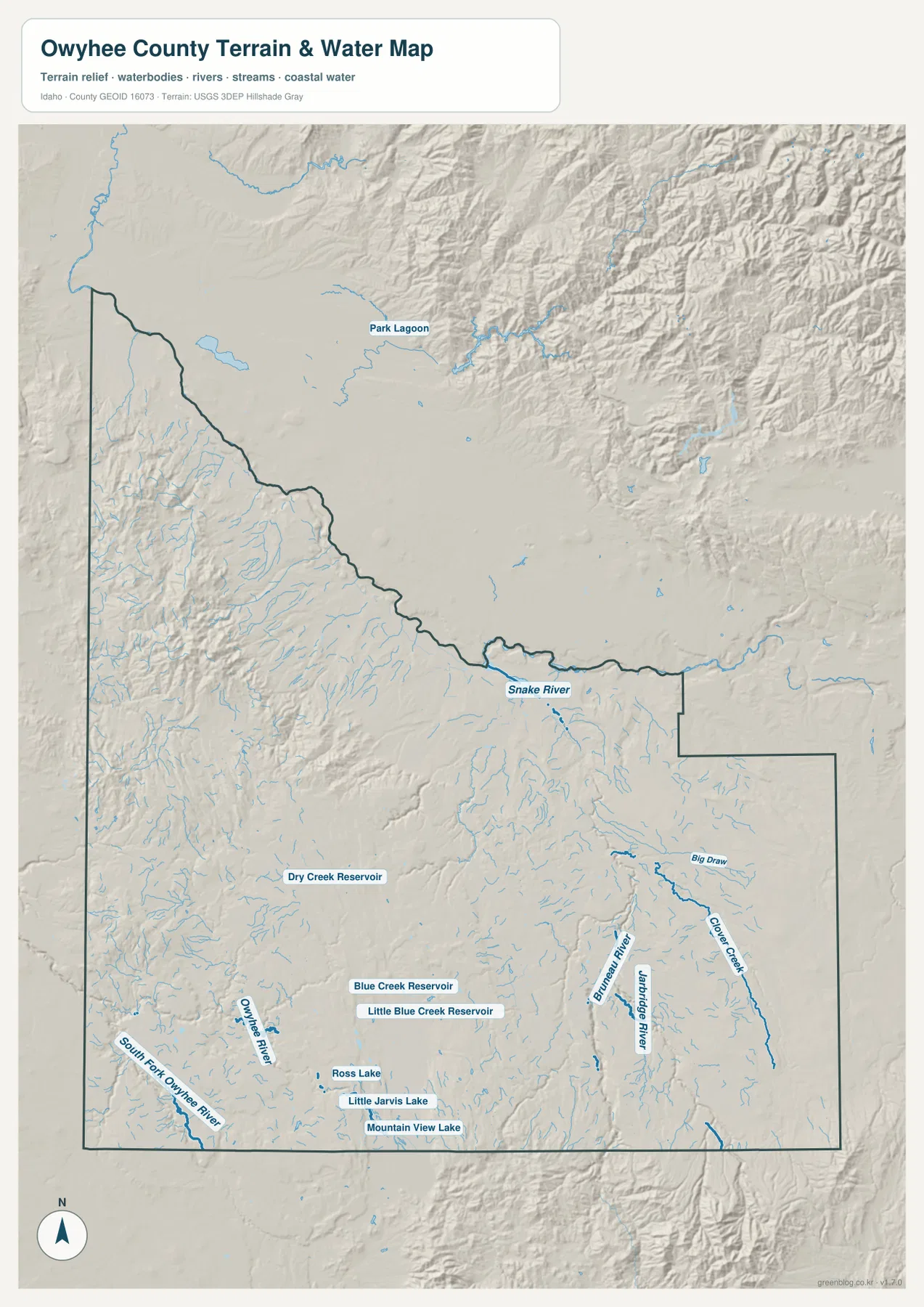
Several named reservoirs and lakes appear in the southern half. Dry Creek Reservoir is labeled west of center, while Blue Creek Reservoir and Little Blue Creek Reservoir are farther south. Ross Lake, Little Jarvis Lake, and Mountain View Lake form another cluster near the southern edge. Park Lagoon is shown north of the county boundary near the Snake River side, giving an additional reference point for the northern water landscape.
Shaded relief helps explain why the streams do not form one simple network. The Owyhee River system occupies western valleys, while Bruneau and Jarbidge rivers drain a different set of canyons and uplands to the east. This map is suitable for locating water features and comparing them with terrain. It is not a flood-hazard map and should not be used for water rights, water quality, depth, reservoir operations, fishing regulations, or navigation decisions.
Elevation from about 670 meters to 2,537 meters
The elevation map reports an actual county range of about 670 to 2,537 meters, with a mean near 1,461 meters. Green colors dominate the lower northern side close to the Snake River. Yellow and brown tones become more common toward the south, southwest, and parts of the central interior, marking broad uplands and higher mountain terrain.
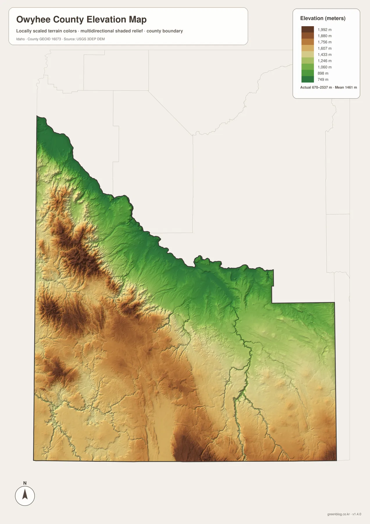
The north-to-south difference helps connect the other maps. Homedale and Marsing occupy the lower northwest, whereas the land south of Murphy rises into more rugged country. The southwest contains repeated ridges and deeply cut valleys, and the eastern side shows river corridors inset between higher ground. That is why the water map and elevation map work especially well when viewed together.
The colors are a generalized representation of county-wide elevation, not a substitute for site surveying. They are useful for comparing broad lowlands, valleys, uplands, and ridges, but they should not be used to determine the exact grade of a road, the elevation of a building lot, or engineering design values. For detailed measurements, consult USGS 3D Elevation Program source data.
Choosing the map that matches the question
Owyhee County is easier to understand when the four views are used for different tasks. The general map is best for the county outline, named towns, and the main road routes. The city map emphasizes how close Homedale and Marsing are compared with Grand View. The water map reveals the separate river systems and named reservoirs, and the elevation map explains the sharp contrast between the Snake River lowlands and the much higher southern interior.
- Boundary and roads: Use the county map for Homedale, Marsing, Murphy, Grand View, US 95, Routes 78 and 51, and the county outline.
- City relationships: Use the city map to compare Marsing and Grand View with Homedale using the labeled straight-line distances.
- Rivers and reservoirs: Use the water map for Snake River, Owyhee River, Bruneau River, Jarbidge River, and the named southern reservoirs and lakes.
- Terrain height: Use the elevation map to compare the lower northern edge with higher southern and southwestern terrain from about 670 to 2,537 meters.
The WebP images on this page are sized for convenient on-screen viewing. For printing, classroom material, local comparison projects, or personal reference, the download below contains the original high-resolution JPG versions. You can use one map on its own or compare several of them side by side when roads, water, and terrain need to be viewed together.
Frequently Asked Questions
Are the 8-mile and 61-mile city distances driving distances?
No. The city map shows straight-line distances from Homedale: about 8 miles to Marsing and about 61 miles to Grand View. Driving distance can be longer because roads must follow the available network and river crossings. Use a current routing service for travel planning.
Which rivers stand out most clearly on the water map?
Snake River is the easiest northern reference because it follows much of the county’s upper edge. Inside the county, Owyhee River and South Fork Owyhee River are prominent in the southwest, while Bruneau River and Jarbidge River are major labeled waterways in the east. Smaller channels and several reservoirs add detail between those systems.
How large is the elevation range across Owyhee County?
The elevation map gives an actual range of roughly 670 to 2,537 meters and a mean of about 1,461 meters. The lowest broad area is near the northern Snake River side, while higher terrain is much more common across the south and southwest. The map is designed for regional comparison, not site-level surveying or engineering measurements.
Map File Information
The county, city, water-and-terrain, and elevation maps for Owyhee County are provided together as original high-resolution JPG files.
- Included Files: Use only the versions confirmed in the article and supplied images
- File Type: Use the confirmed download contents
- Intended Use: Printing, education, presentations, and map-based projects
Related Maps
Sources and references
- U.S. Census Bureau TIGER/Line Shapefiles – official geographic data for county boundaries, roads, and related features
- USGS National Hydrography – river, stream, lake, and reservoir reference data
- USGS 3D Elevation Program – elevation and terrain source data
Green Map creates custom-edited map images using open geographic data sources such as geoBoundaries, Natural Earth, OpenStreetMap, and government open data.
These maps are edited visual materials, not raw data files, and are provided for education, documents, presentations, and graphic reference.