Gosper County lies on the high country of south-central Nebraska between the Platte and Republican river systems. Elwood serves as the county seat, Smithfield is the only other ranked community on the supplied city map, and most of the county is open agricultural land cut by long creek valleys. Elwood Reservoir, Johnson Lake, and Phillips Lake add large water bodies to a landscape that otherwise appears dry and sparsely settled. High-resolution map files are available for download in the section below.
This page explains Elwood and Smithfield, U.S. 283 and Nebraska Highways 18 and 23, Elwood Reservoir, Johnson Lake, Phillips Lake, Plum Creek, Turkey Creek branches, and an elevation range of about 664 to 841 meters. The original high-resolution JPG versions of the supplied maps can also be downloaded together in a ZIP for printing, classroom use, or personal reference.
Table of Contents
Elwood became the county seat after the railroad bypassed an earlier rival
Elwood is the Gosper County seat. The county’s official history says Gosper County was authorized in 1873, formally organized in 1881, and named for John J. Gosper, who served as Nebraska Secretary of State. The county now identifies Elwood and Smithfield as its principal communities, a remarkably small settlement network for more than 450 square miles of land.
Elwood lies in the western half of the county near U.S. 283 and several county roads. Smithfield is farther east near Nebraska Highway 23. Between them and south of them, the map shows large blocks of rural land, scattered reservoirs and creeks, and few named settlements.
Gosper County changed county seats several times before Elwood became permanent. Daviesville was the first seat but never obtained a courthouse. Homerville won the seat in 1882 while residents expected a railroad, yet the railroad ultimately bypassed Homerville and passed through newly platted Elwood. Elwood won a contested county-seat election in 1888, and county buildings were moved there the following year.
U.S. 283 and Highways 18 and 23 organize a sparse rural road network
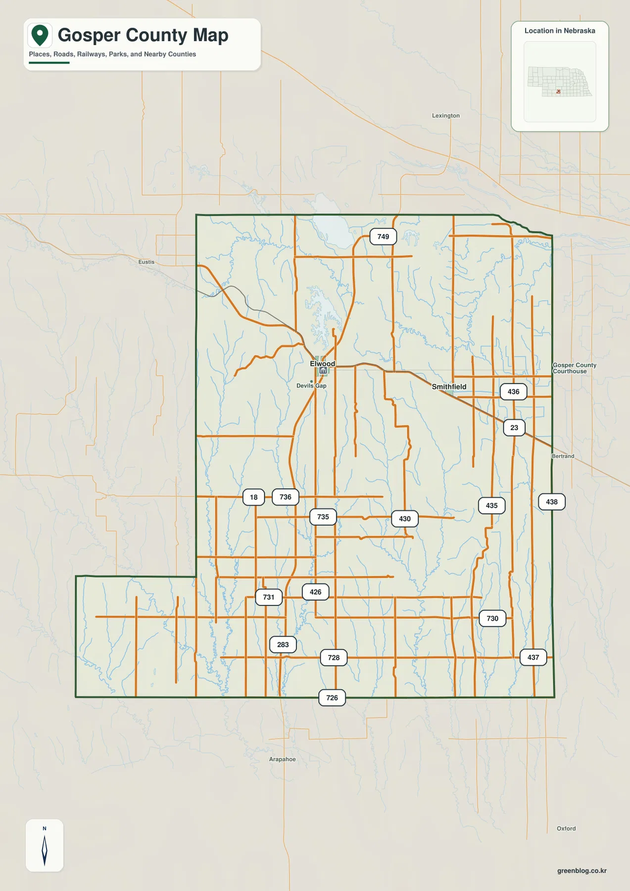
U.S. 283 is the clearest north-south reference on the county map. It passes south of Elwood and continues toward the southern boundary, connecting with roads 731, 728, and 726. Highway 18 crosses the western interior, while Highway 23 serves the eastern side near Smithfield.
Road 749 creates a long northern east-west line, and Road 436 is a useful reference near Smithfield. Roads 435, 437, 438, and 730 appear farther east, while 430, 735, 736, and 426 cross the central countryside. Most of these routes serve farms, ranches, reservoirs, and widely separated rural properties rather than a dense network of towns.
The landscape prevents the county road system from becoming a perfectly regular grid. Creek valleys cut deeply into the central and western tablelands, while the northeastern side drops toward the Platte corridor. Current closures, construction, road surfaces, and seasonal conditions should be checked with Nebraska transportation information before driving remote county roads.
Elwood and Smithfield are the only two ranked communities
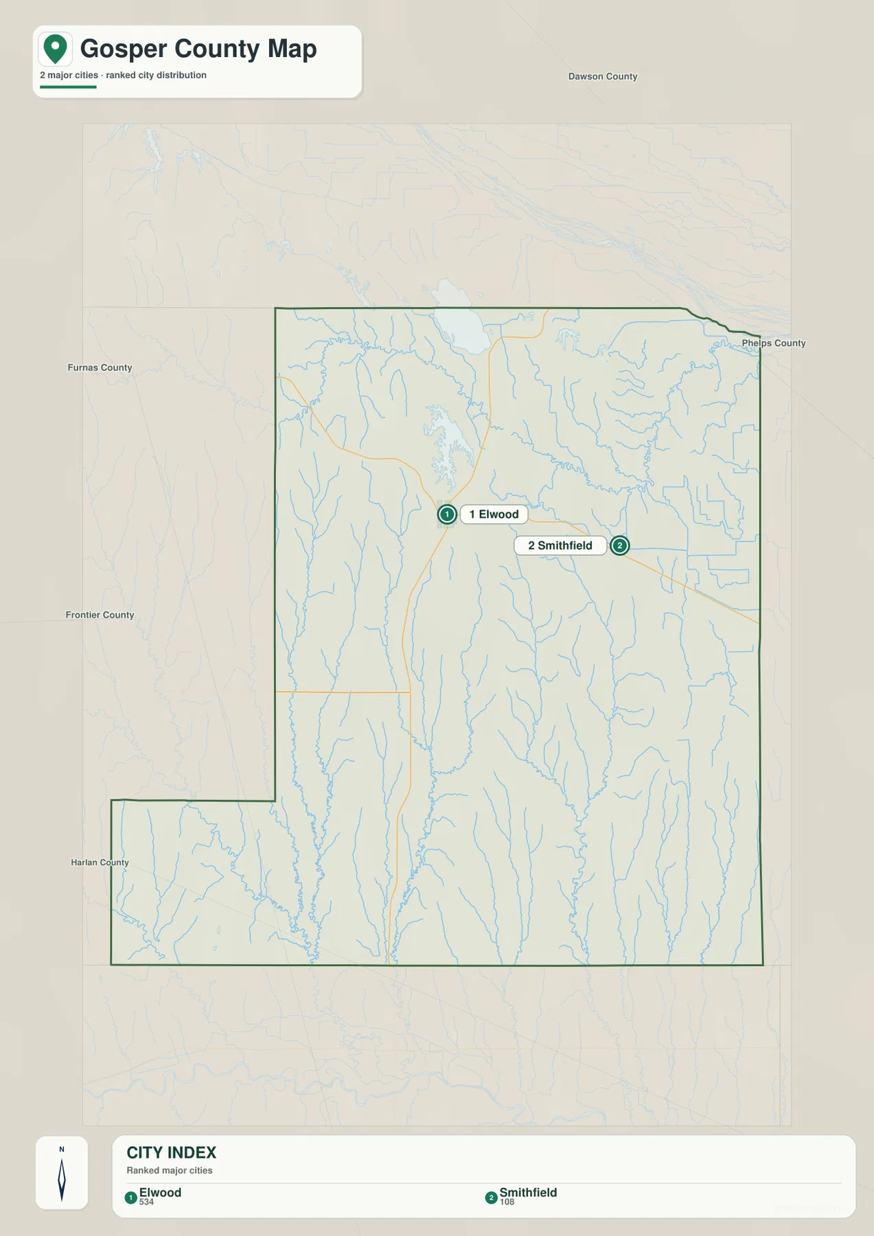
The supplied city distribution map ranks Elwood first and Smithfield second. Elwood sits toward the western side of the northern half, while Smithfield is farther east. No ranked city marker appears across the southern half of the county, which reinforces how lightly settled the interior is.
No connector line or mileage value appears between the two communities. The useful comparison is positional rather than numerical: Elwood relates more closely to U.S. 283 and the reservoir country, while Smithfield sits nearer Highway 23 and the eastern drainage network. A current routing service is the better source for driving distance.
The printed values on the city graphic are 534 for Elwood and 108 for Smithfield. They belong to the supplied ranking rather than a continuously updated demographic table. Current population counts should be checked with the U.S. Census Bureau or Gosper County sources when needed.
Reservoirs and long creek valleys break up the high tableland
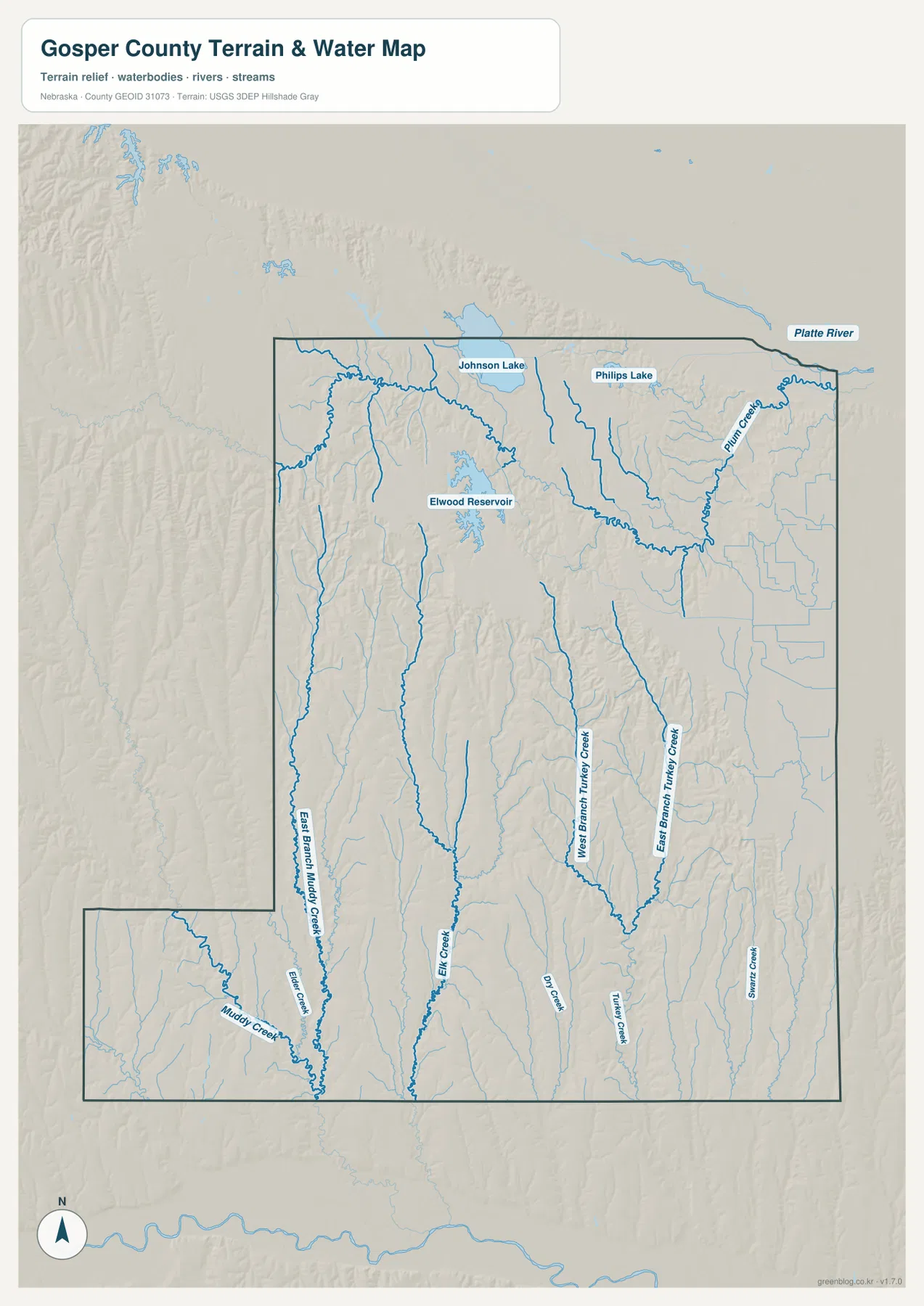
Elwood Reservoir is the most prominent water body in the western interior. Johnson Lake and Phillips Lake appear near the northern edge, with the Platte River corridor immediately beyond or along the county’s northern side. Nebraska Game and Parks describes Johnson Lake as a major recreation lake in the Tri-County Canal system and also manages recreation access at nearby Phillips Canyon.
Plum Creek forms a long, winding drainage across the northeast. Farther south, West Branch Turkey Creek and East Branch Turkey Creek descend through separate valleys before joining the broader Turkey Creek system. Elk Creek and Dry Creek create additional north-south cuts through the central tableland.
East Branch Muddy Creek runs through the western side, while Muddy Creek and Elder Creek occupy the southwestern extension. Swartz Creek appears in the southeast. Together these streams show that Gosper County is shaped less by one large interior river than by many narrow valleys draining away from a higher central surface.
This water map is intended for geographic reference. It does not define flood zones, legal water rights, parcel boundaries, reservoir operations, present water levels, depth, navigability, or public access. Those questions require current information from USGS and the responsible water or recreation agencies.
High central ground stands about 177 meters above the lowest terrain
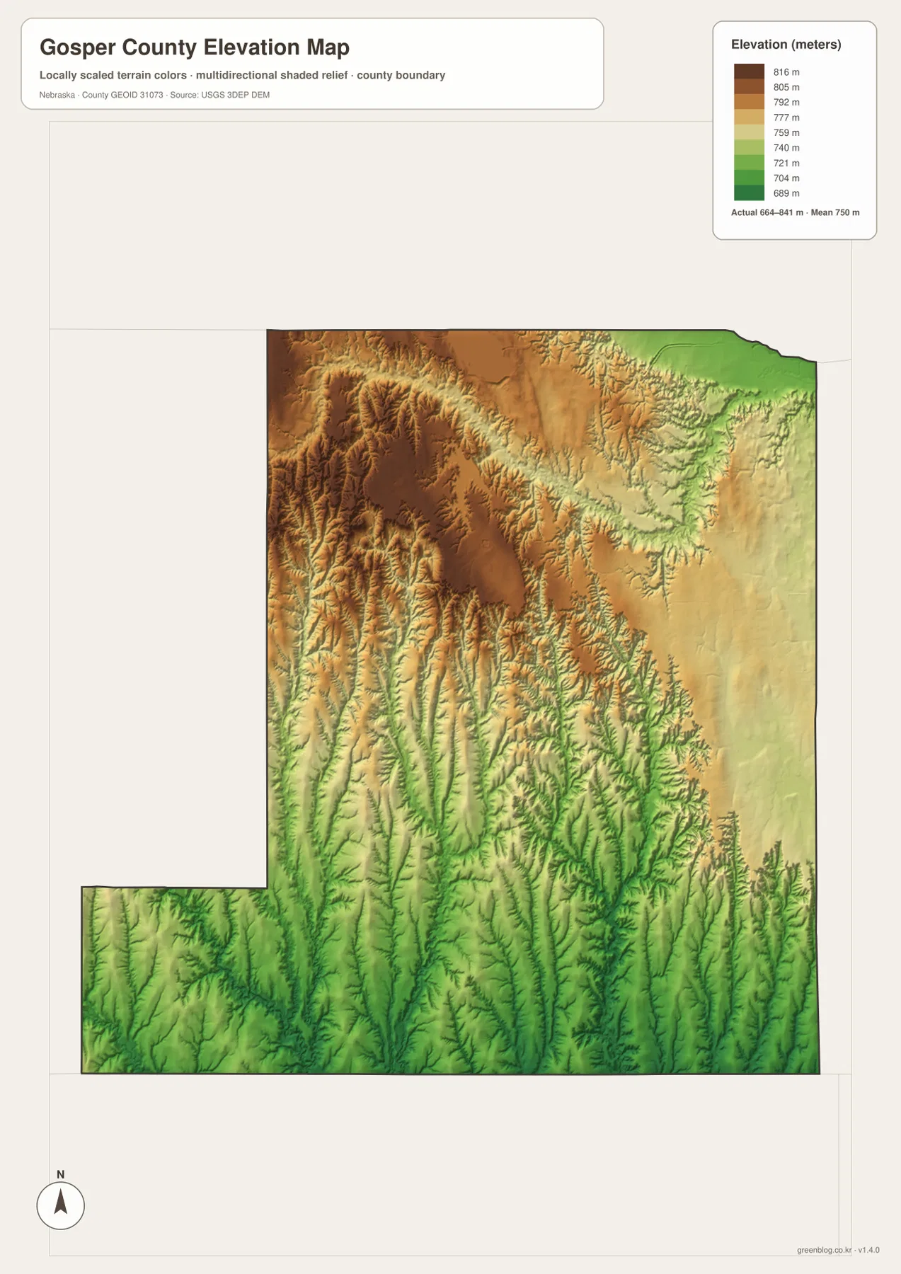
The elevation map reports an actual county-wide range of approximately 664 to 841 meters, with a mean near 750 meters. The highest brown terrain covers much of the west and north-central interior, while green terrain becomes more common toward the northeastern Platte side and in long creek valleys. Total mapped relief is about 177 meters.
Near Elwood and northwest of Elwood Reservoir, the high surface is deeply cut by tributary valleys and short ridges. Moving east toward Plum Creek, the colors gradually shift into lower greens and yellows. Johnson Lake and Phillips Lake also occupy lower northern terrain close to the Platte corridor.
The southern half contains another set of low corridors. East Branch Muddy Creek, Elk Creek, and the Turkey Creek system appear as long green valleys separated by higher agricultural ridges. Comparing the water and elevation maps makes the relationship between stream locations and local relief particularly clear.
The elevation colors are scaled locally for Gosper County and should be used to compare locations within this map. Similar shades on another county map may represent different absolute heights. The generalized surface is not survey-grade information for engineering, construction, drainage design, or property work.
Railroad geography decided the long county-seat contest
Gosper County’s early government moved as towns rose and faded. The official county history says Daviesville first served as the seat, but the county lacked money for a courthouse. Homerville won the designation in 1882 and expected the railroad to bring growth, only to see the line bypass the town.
Elwood was platted in 1885 along the railroad and quickly attracted settlers and businesses. In 1888 it defeated Homerville in a contested county-seat election. The following year, courthouse materials from Homerville were moved to Elwood and reused, completing the shift of county government toward the railroad town that remains the seat today.
Johnson Lake and Phillips Canyon add public recreation to the northern water system
Nebraska Game and Parks describes Johnson Lake State Recreation Area as a major destination for camping, fishing, boating, swimming, and other water recreation. The lake appears prominently on the supplied water map near the county’s northern edge and forms part of the broader Tri-County Canal and reservoir complex.
Phillips Canyon State Recreation Area, near U.S. 283, provides additional boating and fishing access in the same general region. Elwood Reservoir completes a notable cluster of large water bodies around northern Gosper County. Visitors should still check current water levels, access notices, and boating or fishing rules before a trip.
Use Elwood and U.S. 283 as the simplest orientation points
For basic orientation, start at Elwood and follow U.S. 283 south through the county. Highway 18 provides the western east-west reference, while Smithfield and Highway 23 help organize the eastern side. Road 749 and Road 436 are useful secondary references for the northern countryside.
For physical geography, begin with Elwood Reservoir and the northern Johnson and Phillips lakes, then trace Plum Creek and the Turkey Creek branches southward. The elevation map shows the same transition as high brown tablelands break into lower green valleys and the Platte-side lowlands.
The downloadable high-resolution JPG files are useful when county-road numbers or small creek names are difficult to read in the web previews. Starting with Elwood and Smithfield, then comparing the reservoirs, drainage valleys, and elevation surface provides a clear picture of Gosper County without reducing the article to a simple map inventory.
Frequently Asked Questions
Does the city map show the distance between Elwood and Smithfield?
No. The supplied city map ranks and locates Elwood and Smithfield, but it does not include a connector line or mileage value. Use the road map for relative position and a current routing service when actual driving distance is needed.
Where is the highest terrain in Gosper County?
The highest terrain is concentrated across the central and western tablelands. The mapped elevation range is about 664 to 841 meters, with lower ground appearing toward the northeastern Platte side and along the longer creek valleys.
Are Elwood Reservoir and Johnson Lake both shown on the water map?
Yes. Elwood Reservoir is prominent in the western interior, while Johnson Lake and Phillips Lake appear near the northern edge. The map is for geographic reference, so current water levels, access, boating rules, and fishing regulations should be checked with Nebraska Game and Parks.
Map File Information
The ZIP contains the original high-resolution JPG files for the Gosper County boundary and road map, city distribution map, terrain and water map, and elevation map.
- Included Files: Use only the versions confirmed in the article and supplied images
- File Type: Use the confirmed download contents
- Intended Use: Printing, education, presentations, and map-based projects
Related Maps
Sources and references
- Gosper County – About Our County
- Nebraska Association of County Officials – Gosper County
- Nebraska Game and Parks – Johnson Lake
- Nebraska Game and Parks – Phillips Canyon
- USGS National Hydrography
- USGS 3D Elevation Program
These maps are intended for geographic reference. For legal boundaries, land ownership, flood determinations, water rights, road conditions, construction, surveying, or other decisions requiring current authoritative information, consult Gosper County and the responsible state or federal agency.
Green Map creates custom-edited map images using open geographic data sources such as geoBoundaries, Natural Earth, OpenStreetMap, and government open data. These maps are edited visual materials, not raw data files, and are provided for education, documents, presentations, and graphic reference.