Hopkins County is in western Kentucky, and Madisonville is the easiest place to use as a starting point. U.S. 41 runs through the central part of the county, while Dawson Springs, Hanson, Earlington, Nortonville, and White Plains occupy different parts of the surrounding road network. The Tradewater River lies toward the southwest and the Pond River follows the eastern side, so the county makes more sense when roads, towns, streams, and relief are considered together. The maps on this page can be viewed online, and the high-resolution JPG originals are also available together in a downloadable ZIP file for printing or closer inspection.
The county is not mountainous, but it is not uniformly flat either. Lower river and creek corridors alternate with short rolling uplands, and that pattern affects how roads bend between communities. Madisonville forms the strongest central reference point, while Dawson Springs stands apart near the southwestern edge. Looking at both places at once gives a better sense of Hopkins County than focusing on one city alone.
Table of Contents
Madisonville and U.S. 41 anchor the central road network
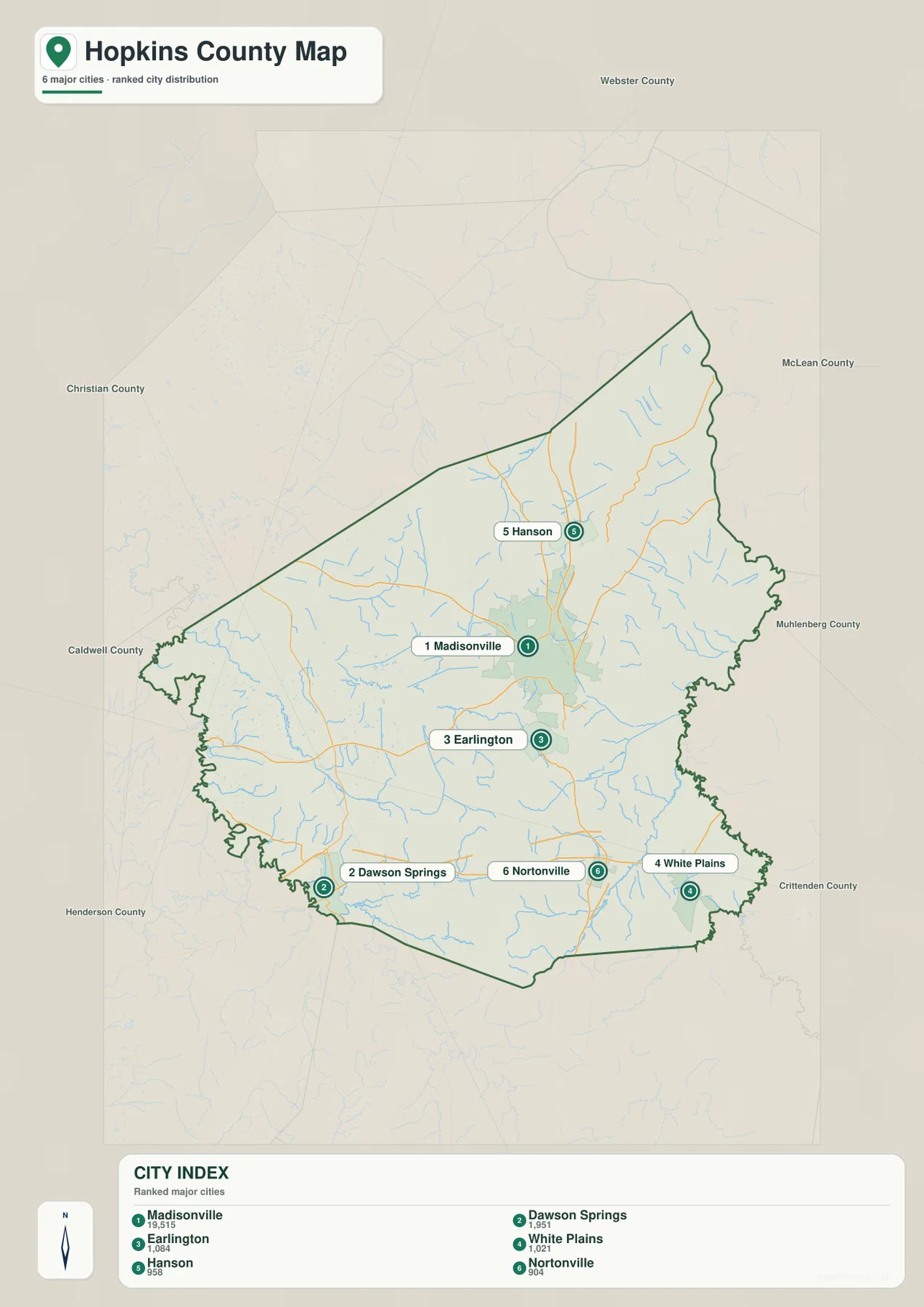
Madisonville is the most prominent city on the county map and sits close to several important road connections. U.S. 41 approaches from the south through the Nortonville and Earlington area, passes Madisonville, and continues north toward Hanson. State routes including KY 70, KY 109, KY 254, and KY 281 provide additional links toward the west, east, and county edges. For a first reading of the map, finding Madisonville and then tracing U.S. 41 north and south is the quickest way to establish orientation.
Nebo and Manitou appear west of Madisonville, while Dawson Springs is farther southwest near the county boundary. White Plains lies to the southeast, and Hanson serves as a northern reference point. The road pattern is not a simple grid: many routes change direction as they cross rolling ground and creek valleys. That makes town names and route numbers more useful together than either feature by itself.
The county boundary also helps place Hopkins County within western Kentucky. Webster County is to the north, McLean and Muhlenberg counties are to the east, and Caldwell County lies along the west and southwest side. Seeing those neighboring counties on the same map is useful when explaining regional location, planning a county-to-county route, or preparing a school or presentation map.
Dawson Springs and smaller towns spread across the county
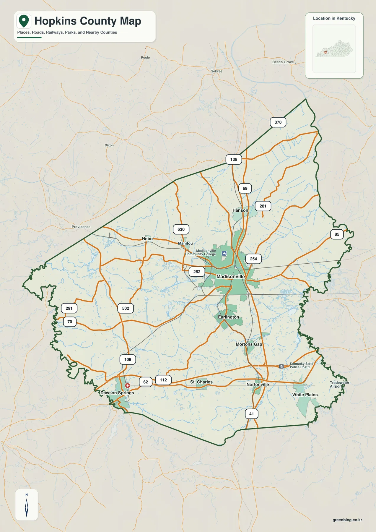
The city map emphasizes six principal places: Madisonville, Dawson Springs, Earlington, White Plains, Hanson, and Nortonville. The map’s reference values are 19,515 for Madisonville, 1,951 for Dawson Springs, 1,084 for Earlington, 1,021 for White Plains, 958 for Hanson, and 904 for Nortonville. These figures are best treated as map reference values rather than current official population estimates; their main purpose here is to show relative city size and placement.
Earlington sits immediately south of Madisonville and feels closely tied to the central area. Hanson is north of Madisonville along the U.S. 41 corridor. Dawson Springs is much farther southwest and works as a separate landmark near the Tradewater drainage, while Nortonville and White Plains occupy different parts of the southern half of the county. This spread of towns shows why Hopkins County cannot be understood as a single compact urban area.
The Hopkins County Fiscal Court also identifies several municipalities and communities beyond Madisonville, including Dawson Springs, Earlington, Hanson, Mortons Gap, Nebo, Nortonville, St. Charles, and White Plains. That local context matches what the maps show: one dominant county center surrounded by smaller towns and rural areas connected by a network of highways and state roads. For navigation, it is usually easiest to identify the nearest town first and then follow the larger numbered road toward the destination.
Tradewater and Pond rivers frame a dense creek network
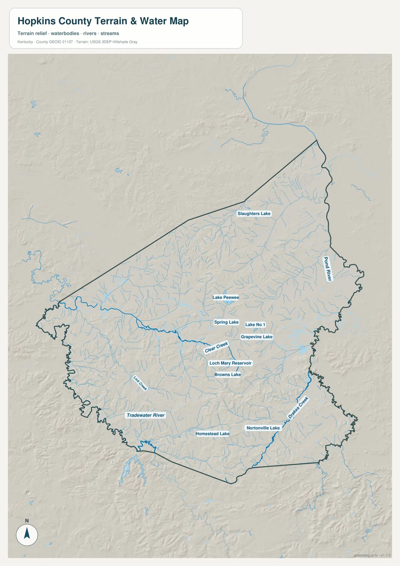
Two larger waterways provide useful geographic anchors. The Tradewater River follows the southwestern side of Hopkins County, while the Pond River runs along the eastern side. Between them are Drakes Creek, Clear Creek, Elk Creek, and many shorter tributaries. This network is important because the lower stream corridors divide the county’s rolling uplands into a series of smaller ridges and valleys.
Several lakes and reservoirs also appear on the water map. Slaughters Lake is in the north, while Lake Peewee, Grapevine Lake, Loch Mary Reservoir, Browns Lake, and other small water bodies occur closer to the central and southern parts of the county. Nortonville Lake is another useful southern reference point. These features are not comparable in size to the main rivers, but they are helpful landmarks when zooming in on local roads and nearby communities.
Comparing the water map with the road map explains why some routes bend rather than following straight lines. Roads often cross creeks at lower points or curve around shallow valleys and uplands. The water file should be treated as a county-scale geographic reference only. It is not a flood-zone map, a live river-stage product, a parcel map, a drainage design, or a navigation chart; those uses require current agency data designed for the specific task.
Relief ranges from 95 to 219 meters across valleys and uplands
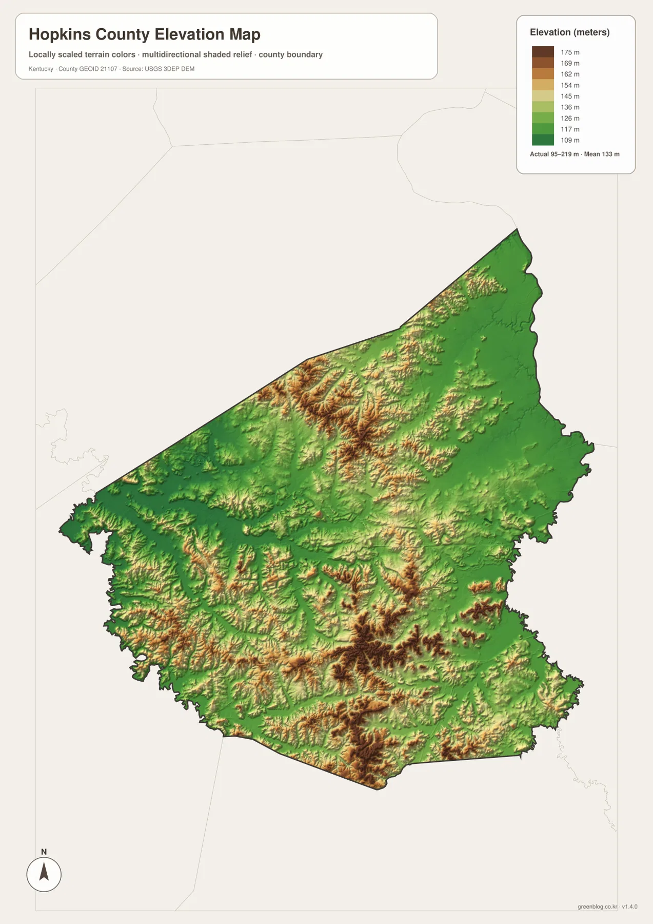
The elevation map shows an actual range of about 95 to 219 meters, with a mean of 133 meters. The lowest colors follow the Tradewater River, Pond River, and other creek valleys. Madisonville itself sits in terrain that mixes shallow low areas with rolling ground rather than one uninterrupted flat surface. Broader areas above the valley floors appear through the central and northern parts of the county.
Higher tan and brown areas are most noticeable in the north-central interior and in parts of the south and southeast. They are short uplands rather than long mountain ridges. When the locations of Clear Creek, Drakes Creek, and the Tradewater River are compared with the elevation colors, the recurring pattern is straightforward: streams occupy lower corridors and the land rises between them.
The mean elevation of 133 meters should not be read as a typical height for every location. Hopkins County includes valley floors near 100 meters and uplands above 200 meters, so local relief can change over relatively short distances. This rendered map is intended for county-scale comparison. Surveying, engineering, construction, site grading, and flood-risk work should use original USGS elevation data, FEMA products, or professional measurements instead of this generalized visualization.
Choose the file by the question you need to answer
For roads, county boundaries, nearby counties, and the relationship among towns, the general county map is the best starting point. It gives the clearest view of U.S. 41 together with KY 70, KY 109, KY 254, KY 281, and the smaller communities around Madisonville. The city map is cleaner when the goal is to compare where Madisonville, Dawson Springs, Hanson, Earlington, Nortonville, and White Plains sit relative to one another.
Use the water map when the Tradewater River, Pond River, Drakes Creek, Clear Creek, or the county’s lakes are the main subject. The elevation map adds another layer by separating low creek corridors from surrounding uplands. Looking at those two files side by side is particularly helpful in Hopkins County because its relief comes from many short valleys and ridges rather than a single major mountain front.
The WebP images embedded on this page are optimized for quick online viewing. The ZIP below contains the high-resolution JPG originals, which are better for printing, enlarging labels, or placing the maps into a presentation or local reference document. Select the county, city, water, or elevation file according to the type of detail you need rather than trying to force one map to answer every question.
Frequently Asked Questions
What is the easiest place to start when reading a Hopkins County map?
Madisonville is the simplest starting point because it is the largest city reference and sits near the center of the main road network. From Madisonville, Hanson is north along the U.S. 41 corridor, Earlington and Nortonville are south, Dawson Springs is southwest, and White Plains is southeast.
Which file is best for comparing the Tradewater River and Pond River?
Use the water map. It shows both larger rivers together with Drakes Creek, Clear Creek, Elk Creek, and several lakes and reservoirs. Pairing it with the elevation map also shows how many of those waterways occupy the lower parts of the county.
Can the 95–219 m elevation map be used for surveying or flood decisions?
No. The elevation image is a county-scale reference for broad relief. Precise site elevations, construction, surveying, engineering, and flood-risk decisions require original agency datasets or professional measurements rather than this rendered overview.
Map File Information
The high-resolution JPG originals used for this Hopkins County article are bundled in one ZIP archive for printing and closer inspection of labels.
- File Type: JPG
Related Maps
Sources and References
County government and local context are available from the Hopkins County Fiscal Court and the Hopkins County Tourist & Convention Commission. Boundary and road references are supported by U.S. Census Bureau TIGER/Line, water features by USGS National Hydrography, and elevation data by the USGS 3D Elevation Program.
Green Map creates custom-edited map images using open geographic data sources such as geoBoundaries, Natural Earth, OpenStreetMap, and government open data. These maps are edited visual materials, not raw data files, and are provided for education, documents, presentations, and graphic reference.