Dubuque County sits on Iowa’s eastern edge where the Mississippi River meets steep tributary valleys and rolling uplands. The city of Dubuque occupies the river side of the county, while Dyersville anchors the west and Cascade provides a useful reference point near the southern edge. U.S. 20 runs west from Dubuque through Peosta and Epworth, U.S. 52 connects the Dyersville area with the northwest, and U.S. 61 follows a north-south line near the river side of the county. U.S. 151 approaches from the southwest through the Cascade corridor. This page explains those settlements and roads, the Little Maquoketa drainage, the Mississippi shoreline, and the 181–380 m elevation range. You can download all four supplied maps below as high-resolution JPG files for printing, classroom use, presentations, or closer reference.
A useful way to orient yourself is to start with Dubuque at the Mississippi River and then move inland. Asbury lies immediately west of the city, Peosta is farther along the U.S. 20 corridor, and Epworth continues that westward sequence. Dyersville is farther west and slightly north, while Cascade lies to the southwest. North of the main U.S. 20 corridor are smaller places such as Sageville, Rickardsville, Holy Cross, and New Vienna. The terrain and water maps show why these places do not sit on one broad flat plain: the Little Maquoketa River system and numerous short creeks cut repeated valleys between higher ridges.
Table of Contents
Roads and settlements from Dubuque to Dyersville
The county overview makes the east-west structure especially clear. Dubuque is concentrated at the Mississippi River on the eastern side, and U.S. 20 leaves the city toward Peosta and Epworth. Dyersville is farther west where U.S. 52 and nearby state roads provide another regional connection. Iowa 3 crosses the northern part of the county near Holy Cross, while Iowa 136 descends south from the Dyersville area toward Worthington and Cascade. Near the southeast, U.S. 61 gives the river side of the county a strong north-south route, and U.S. 151 connects the Cascade direction with the approaches to Dubuque.
The Dubuque urban area contains the densest cluster of roads and named places. Asbury is directly to the west, Sageville is north of the main city, and Peosta appears farther inland along U.S. 20. Centralia is a smaller settlement near the middle of the county. Rickardsville and New Vienna provide additional northern reference points, while Cascade stands apart in the southwest. This arrangement is helpful for seeing the county as a set of connected corridors rather than as a single city surrounded by empty space.
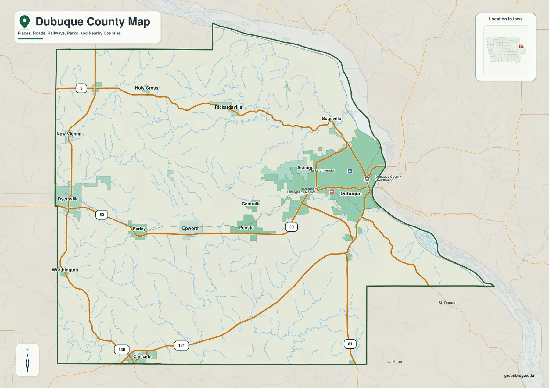
This overview is best used for relative location rather than turn-by-turn navigation. It shows how far Dubuque sits toward the river, where Dyersville and Cascade fall within the county, and how the principal highways connect those places. Road conditions, construction, and local access can change, so current navigation services should be used for an actual trip.
Major cities centered on Dubuque, Asbury, and the U.S. 20 corridor
The ranked city map highlights six places: Dubuque, Asbury, Dyersville, Cascade, Peosta, and Epworth. Dubuque is by far the largest at 59,174 residents and forms the principal urban center at the Mississippi River. Asbury, shown at 5,989, is immediately west of Dubuque. Dyersville has 4,423 residents and serves as the main western city on the map, while Cascade has 2,275 near the southern edge. Peosta, with 2,040, and Epworth, with 1,894, fill the space between Dubuque and the west side of the county.
The pattern is not simply a string of towns from east to west. Dubuque and Asbury form a close urban pair, Dyersville has a separate western position, and Cascade is offset to the southwest. Peosta and Epworth create intermediate points along the U.S. 20 side of the county. That distribution makes the city map useful when the full road and stream network on the county overview is more detail than you need.
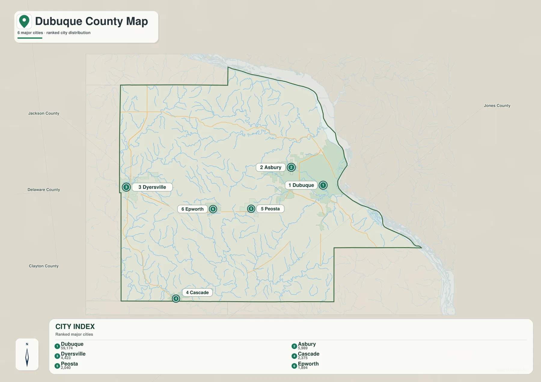
Once those six places are familiar, the other maps become easier to interpret. Peosta and Epworth provide inland markers along U.S. 20, Dyersville helps locate the western drainage network, and Dubuque defines the low river side. Cascade is a useful southern reference for the U.S. 151 corridor. Linking city names to these broader features gives the county a clearer geographic structure than memorizing place names by themselves.
Mississippi River lowlands and the Little Maquoketa drainage
The Mississippi River dominates the eastern boundary and creates the broadest low corridor on the water-and-terrain map. Dubuque sits directly beside it. Inland, the Little Maquoketa system cuts a complex set of valleys through the northern and central county. North Fork Little Maquoketa River is labeled across the northern uplands, while the Mid Fork and Middle Fork channels occupy separate interior valleys. The Little Maquoketa River then continues eastward toward the Mississippi side of the county.
Catfish Creek is marked south of Dubuque and provides another clear valley close to the urban area. Whitewater Creek and numerous smaller tributaries extend across the central and southern interior. Even where a stream is not named on the preview, the relief makes its valley visible. The result is a landscape of short ridges separated by branching drainage lines rather than one continuous flat surface.
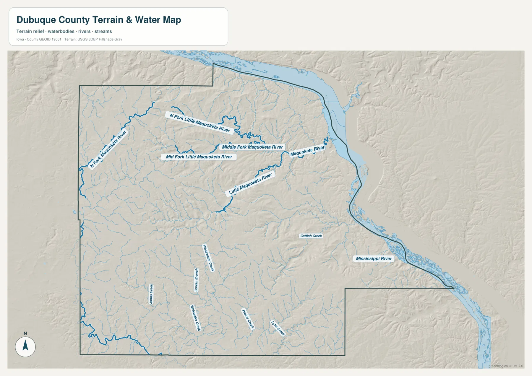
This is a geographic water reference, not a flood-risk or navigation chart. It is intended to show the relative positions of rivers, creeks, and valley systems. Flood hazards, current water levels, or navigational conditions require separate up-to-date sources.
181–380 m elevation reveals sharp river-to-upland contrast
The elevation map reports an actual county range from about 181 to 380 meters, with a mean of 293 meters. The lowest terrain follows the Mississippi River along the east and appears as a narrow green corridor. Other low strips trace the Little Maquoketa and its tributaries inland. By contrast, the western and northwestern interior contains broad areas of brown and dark tan, indicating substantially higher ground. Ridges also appear between the branching valleys across the center of the county.
The higher terrain is not a single smooth plateau. Tributaries repeatedly cut into it, producing short slopes and narrow low areas that point toward larger valleys. This pattern is especially clear in the north, where the Little Maquoketa network divides the uplands into many ridges. Closer to the Mississippi River, the relief drops more quickly toward the broad river corridor. Comparing the water and elevation maps makes the relationship between streams and lower terrain much easier to see.
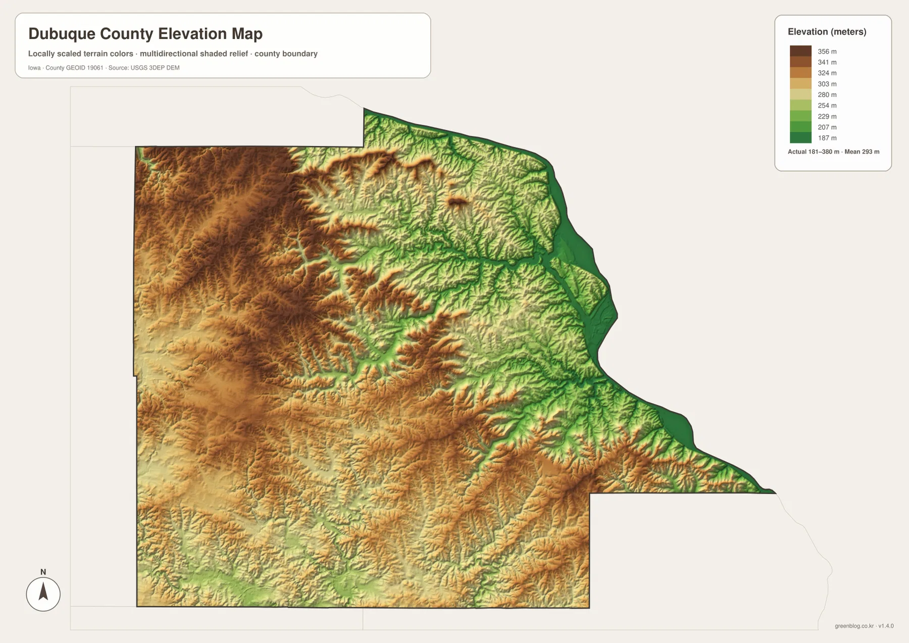
The elevation surface is appropriate for county-scale comparison, not survey-grade measurement. Parcel elevations, engineering design, road grade, and building work require original elevation data or professional surveying. Here, the map is most useful for identifying which parts of the county are relatively high or low and for understanding how the valleys relate to roads and settlements.
Using the road and river networks together
Two reference lines simplify the county: U.S. 20 for the inland city corridor and the Mississippi River for the eastern edge. Starting at Dubuque, U.S. 20 leads toward Peosta and Epworth and helps organize the interior settlements. Dyersville lies farther west, while Cascade marks the southwest. The Mississippi, meanwhile, immediately identifies the county’s lowest major corridor and explains why Dubuque occupies such a distinct position from the inland towns.
For terrain, follow the Little Maquoketa branches instead. Their valleys divide the north and center into a web of ridges and lower channels. Catfish Creek adds another valley just south of Dubuque. When these waterways are compared with the elevation map, the pattern of low green corridors and higher interstream ridges becomes clear without needing specialized GIS terminology.
Choosing the right Dubuque County map
Use the county overview when you want cities, roads, streams, and boundaries together. The city map is faster for comparing Dubuque, Asbury, Dyersville, Cascade, Peosta, and Epworth without the full road network. The terrain-and-water sheet is the better choice for the Mississippi River, Little Maquoketa system, and tributary valleys. For relative height, the elevation map shows the 181–380 m range and the contrast between river lowlands and interior uplands.
The WebP images in the article are sized for quick viewing online. The ZIP below contains the same four map types as high-resolution JPG files for printing, classroom use, presentations, and closer inspection. They are general reference maps and should not be used as legal boundary documents, parcel records, live traffic products, flood determinations, or precision elevation measurements.
Frequently Asked Questions
Which map is best for comparing Dubuque and Dyersville?
The county overview is the best starting point because it shows both cities, the settlements between them, and the main roads that cross the county.
What are the main waterways shown in Dubuque County?
The Mississippi River defines the eastern side of the county. Inland, the Little Maquoketa River and its branches create prominent valleys, while Catfish Creek marks another drainage south of Dubuque.
How should the 181–380 m elevation range be interpreted?
The Mississippi River edge and major tributary valleys are the lower parts of the county, while the western and northwestern uplands are generally higher. The mean shown on the map is 293 meters, and the surface is intended for broad terrain comparison rather than engineering measurements.
Map File Information
The ZIP contains high-resolution JPG versions of the county overview, major-city map, terrain-and-water map, and elevation map for Dubuque County, Iowa.
- Included Files: 4 high-resolution JPG maps
Related Maps
Sources and reference data
The official resources below are useful when you need original boundary, hydrography, or elevation data. The maps on this page are designed as readable county references, so specialized analysis should be checked against the underlying datasets.
Use current agency information for legal boundaries, parcel ownership, road conditions, water levels, flood hazards, or precision elevations. These maps are intended for general orientation, education, printing, and visual reference.
Green Map creates custom-edited map images using open geographic data sources such as geoBoundaries, Natural Earth, OpenStreetMap, and government open data.
These maps are edited visual materials, not raw data files, and are provided for education, documents, presentations, and graphic reference.