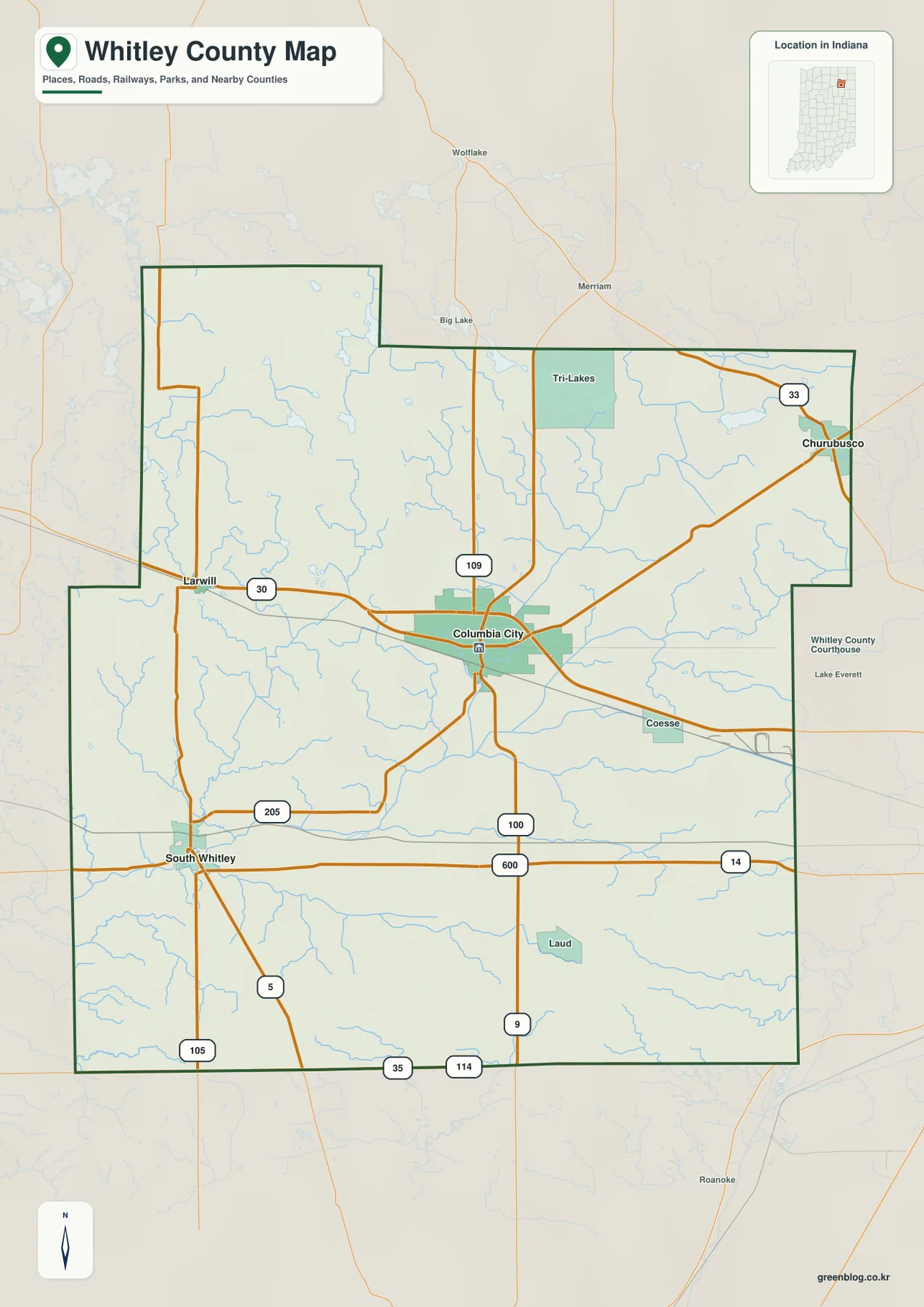
Whitley County is in northeastern Indiana, and this page brings its roads, communities, waterways, and relief together in a set of downloadable maps. High-resolution JPG originals are available in a ZIP archive, so readers can study the on-page WebP images first and then download the larger files for printing, classroom use, presentations, or reference work. Columbia City provides the main point of orientation, while Churubusco, South Whitley, and Larwill show how the county spreads in different directions from its central community.
The geography changes noticeably as the view moves north and south. A cluster of named lakes occupies the northern part of the county, the Eel River crosses the southwest, and the Blue River runs through the central and northeastern area. The elevation map adds another layer: higher and more broken ground is concentrated toward the north and northwest, while much of the center and south is lower. The sections below use those county-specific features to explain what each map is best at showing rather than treating the images as interchangeable versions of the same picture.
Table of Contents
Columbia City anchors the road pattern and the county outline
On the general county map, Columbia City is the easiest place to start. The built-up area lies close to the middle of Whitley County, and several important roads meet or pass nearby. US 30 runs west toward Larwill, routes extend northeast toward Churubusco, and other roads lead southwest toward South Whitley and south across the lower half of the county. That arrangement makes Columbia City a practical reference point when explaining where another place sits or which direction a route leaves the county seat.
The boundary itself is not a simple rectangle. The northwestern edge steps inward and outward, and the northeastern side has a similar notch before continuing south. Neighboring county names help place Whitley County within the region: Noble County is to the north, Allen County to the east, Huntington and Wabash counties along the south, and Kosciusko County to the west. For readers who know a nearby county better than Whitley County, those labels provide an immediate regional frame of reference.
Smaller place names such as Tri-Lakes, Coesse, and Laud add useful detail without turning the map into a street atlas. Around Columbia City, the road network and developed area appear denser, while large sections of the southeast and northwest look more open and rural. The map is therefore useful for countywide orientation—boundaries, roads, settlements, and surrounding counties in one view—but it should not be used as a parcel survey or legal boundary record.
Churubusco, South Whitley, and Larwill spread away from the county seat
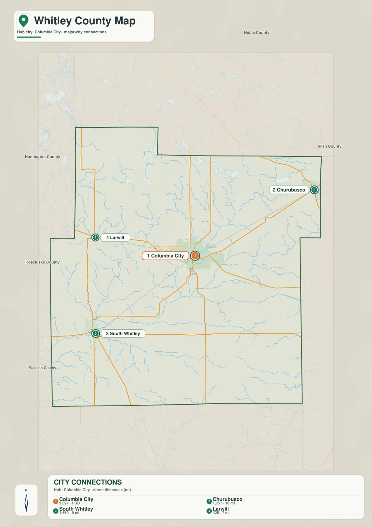
The city-connections map simplifies the county to four reference communities. Columbia City is the hub, Churubusco lies to the northeast, South Whitley sits to the southwest, and Larwill is west of the county seat. With most of the smaller labels removed, the map is especially effective for a short county introduction, a presentation slide, or any explanation where the main question is direction rather than road-by-road navigation.
Straight-line distances from Columbia City are printed beside the community labels. Churubusco is shown at roughly 10 miles, South Whitley at about 9 miles, and Larwill at about 7 miles. These are not driving distances. Real routes bend, intersect, and begin from different points inside each community, so the figures are best used to compare relative separation. A road-routing service or current highway map is the proper tool when travel time or actual mileage matters.
The direction of the three smaller communities also explains the spoke-like road pattern on the general map. Churubusco sits near the northeastern edge toward Allen County, South Whitley is in the southwest near the Eel River area, and Larwill is close to the western boundary. Columbia City lies between them. Whitley County planning material identifies Columbia City as the county seat and largest community while also recognizing Churubusco, South Whitley, and Larwill as important organized communities, which fits the simplified arrangement shown here.
Northern lakes contrast with the Eel and Blue river corridors
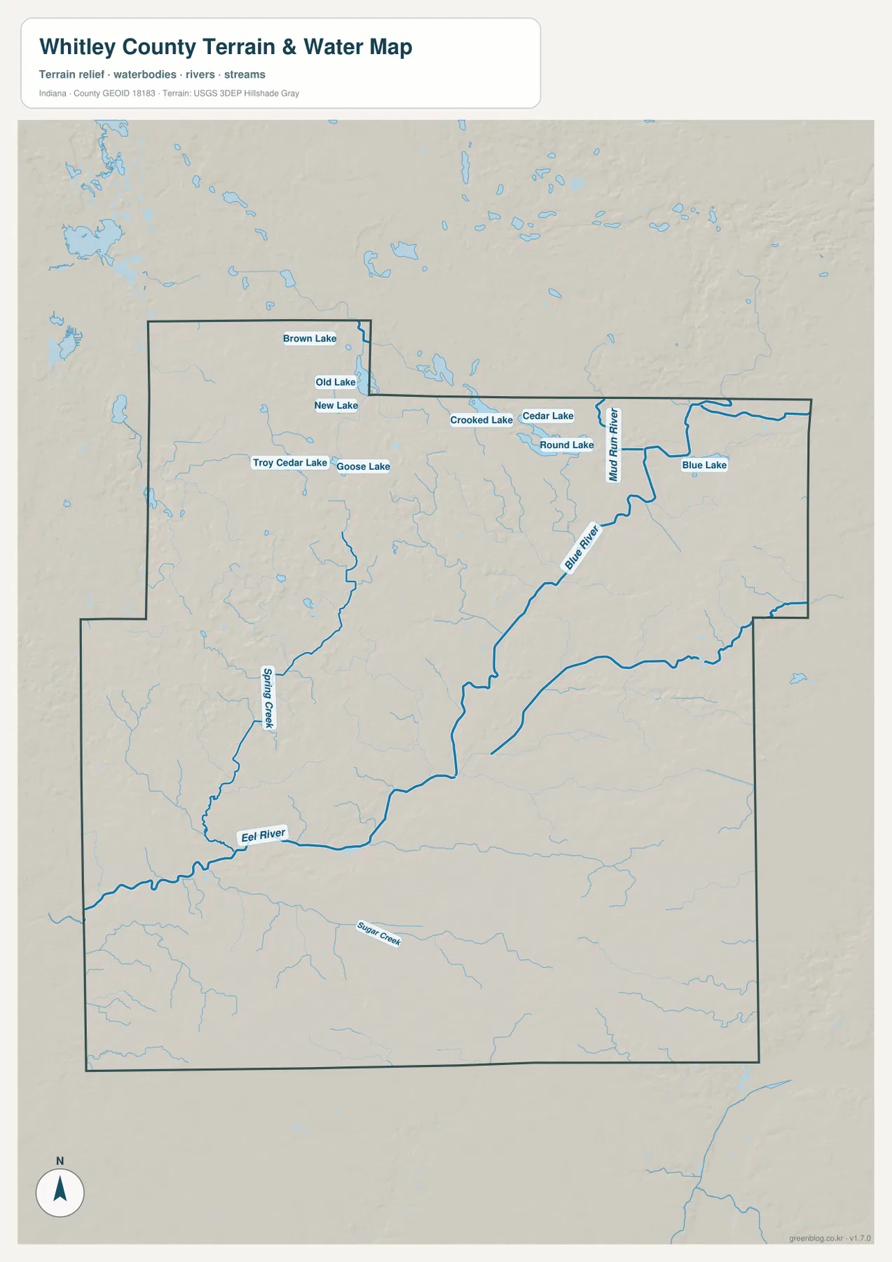
The terrain-and-water map shifts attention away from roads and toward named water features. The Eel River is prominent in the southwestern part of the county. The Blue River runs through the central and northeastern area, while Spring Creek and Sugar Creek appear farther west and south. Mud Run is labeled in the northeast. Seeing those lines together makes it clear that Whitley County contains several distinct stream corridors rather than one single drainage line crossing the county.
The northern lake cluster is the most distinctive feature on this map. Brown Lake, Old Lake, New Lake, Crooked Lake, Cedar Lake, Round Lake, and Blue Lake appear across the upper part of the county, with Troy Cedar Lake and Goose Lake farther west. The south looks different: longer stream lines and broad areas between them dominate instead of a tight group of lakes. That contrast makes the water map particularly useful for explaining why the northern part of Whitley County has a different physical character from the lower half.
Whitley County’s official comprehensive planning material describes several major drainage areas and notes the importance of the Eel River basin. It also characterizes land north of the Eel River as more hilly and marked by depressions and lakes, while areas to the south are generally gentler or flatter. The supplied map visually supports that broad description, but it is not a flood map, navigation chart, wetland determination, or legal water-boundary document. Those decisions require the relevant official datasets.
Elevation rises toward the northwest and falls across much of the center and south
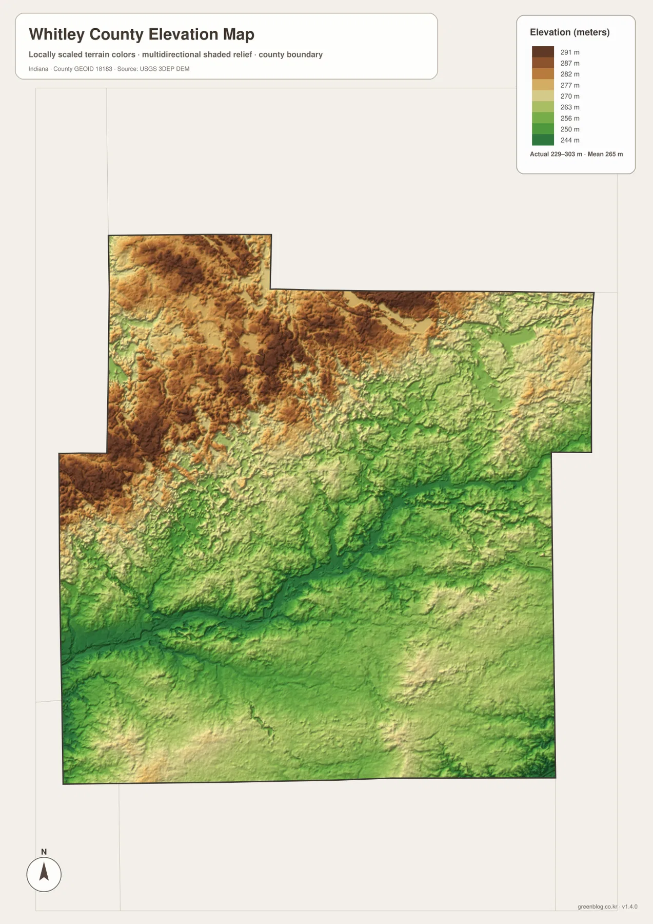
The elevation map uses a county-scaled color ramp to show relative height. Its legend gives an overall range of about 229 to 303 meters and a mean near 265 meters. Browns and tans mark higher terrain, while greens mark lower terrain. The strongest area of higher ground is concentrated across the north and northwest. Moving toward Columbia City and farther south, green tones become more common, creating a clear countywide contrast.
That pattern becomes more meaningful when it is compared with the water map. The northern lake district sits within a landscape where high and low ground changes frequently, rather than on one smooth flat surface. In the southwest, the Eel River follows lower terrain, and broad parts of the southern county remain within the greener portion of the scale. The two maps therefore complement each other: one identifies the water features, while the other explains the surrounding relief.
The legend should not be treated as a survey certificate. The map is designed to communicate countywide relief, not the exact elevation of a parcel, road crossing, drainage structure, or building site. Engineering, construction, drainage design, and land surveying require current authoritative elevation data or a professional site survey. For general geographic explanation, however, the map clearly shows that Whitley County is not uniformly flat and that the northern terrain is more irregular than much of the south.
Choose the map for the question, then download the high-resolution JPG files
Use the general county map when the task involves boundaries, major roads, several place names, and neighboring counties at the same time. The city-connections map is better when Columbia City, Churubusco, South Whitley, and Larwill are the only locations that need to be compared. For rivers, creeks, and the northern lake cluster, the terrain-and-water view removes enough road detail to make the water network easier to follow. The elevation map is the most direct choice for comparing higher northern ground with lower central and southern terrain.
The WebP images in the article are optimized for convenient viewing. The download archive contains the corresponding original JPG files at 2572×3638 pixels: one county map, one city map, one terrain-and-water map, and one elevation map. Each image is stored separately, so a reader can extract only the map needed for a report, lesson, printout, or presentation. For legal boundaries, flood safety, engineering, navigation, or other decisions that depend on precise data, use the current source datasets rather than these simplified graphics.
Frequently Asked Questions
Which map is best for comparing Columbia City with Churubusco, South Whitley, and Larwill?
The city-connections map is the quickest choice because it isolates those four communities and uses Columbia City as the hub. Churubusco is northeast, South Whitley southwest, and Larwill west, with straight-line distances shown beside the labels. Use the general county map when you also need the road network, smaller places, waterways, or the county boundary.
Where are Whitley County’s northern lakes easiest to see?
The terrain-and-water map shows them most clearly. Brown Lake, Crooked Lake, Cedar Lake, Round Lake, Blue Lake, and several other named lakes are concentrated across the northern part of the county. Pairing that view with the elevation map also shows how the lake district sits within the more irregular northern terrain.
Can the 229–303 meter elevation range be used for surveying or construction?
No. The range summarizes the countywide surface used for this visualization and is useful for understanding relative relief, but it is not a precise elevation for a specific property or structure. Surveying, engineering, drainage design, and construction decisions require authoritative elevation data or a professional site survey.
Map File Information
Download the Whitley County maps as high-resolution JPG files in one ZIP archive. The archive contains separate originals for the county, city, terrain and water, and elevation views.
- Printable Size: 2572×3638 pixels each
- File Type: ZIP containing 4 JPG files
Related Maps
Sources and references
These official sources provide background for the county description and for the boundary, hydrography, and elevation information represented in the maps. The graphics on this page are simplified reference products; authoritative source data should be used when exact or legally significant information is required.
- Whitley County official comprehensive planning material – communities, watersheds, and terrain description
- U.S. Census Bureau TIGER/Line Shapefiles – county boundaries and geographic framework
- USGS National Hydrography – rivers, streams, lakes, and other water features
- USGS 3D Elevation Program – elevation and terrain data
Green Map creates custom-edited map images using open geographic data sources such as geoBoundaries, Natural Earth, OpenStreetMap, and government open data.
These maps are edited visual materials, not raw data files, and are provided for education, documents, presentations, and graphic reference.