Crawford County in southeastern Illinois is easiest to orient around Robinson. Route 33 runs across the middle of the county, linking Oblong and Stoy west of Robinson with Palestine to the east. Route 1 crosses the eastern-central area and provides the north-south reference for Hutsonville and Flat Rock. The towns are fairly easy to place, but the land between them is cut by many creeks and shallow valleys, so the terrain is more varied than the road grid first suggests.
The map set follows that geography from the Route 33 town chain to the water system and relief. The city view reduces the county to six labeled places, the terrain map highlights Embarras River and a network of named creeks, and the elevation image shows higher north-central and southeastern ridges above lower stream corridors. High-resolution JPG originals of the supplied maps are packaged in one ZIP download for enlargement, printing, classroom work, or presentation material.
Illinois State Archives records show that Crawford County was established on December 31, 1816. Palestine served as the county seat from 1818 to 1843, after which Robinson became the seat and has remained so. The current Crawford County government website is also based in Robinson. That history adds useful context to the map’s central east-west relationship between Robinson and Palestine.
Table of Contents
Route 33 connects Oblong, Robinson, and Palestine
The county overview has a very clear east-west organizing line. Route 33 enters from the west, passes through Oblong and Stoy, reaches Robinson, and continues east to Palestine. Lincoln Trail College is labeled on the eastern side of Robinson, reinforcing the city’s larger mapped footprint. Remembering that road chain gives the central part of Crawford County a simple structure before the smaller tributaries and local roads are considered.
Route 1 supplies the second major reference. It runs north toward Hutsonville and West York and south toward Flat Rock. Palestine lies just east of that north-south corridor, while the western towns remain tied more closely to Route 33. The combination of one long east-west route and one strong vertical route makes the settlement pattern easier to learn than the dense stream network beneath it.
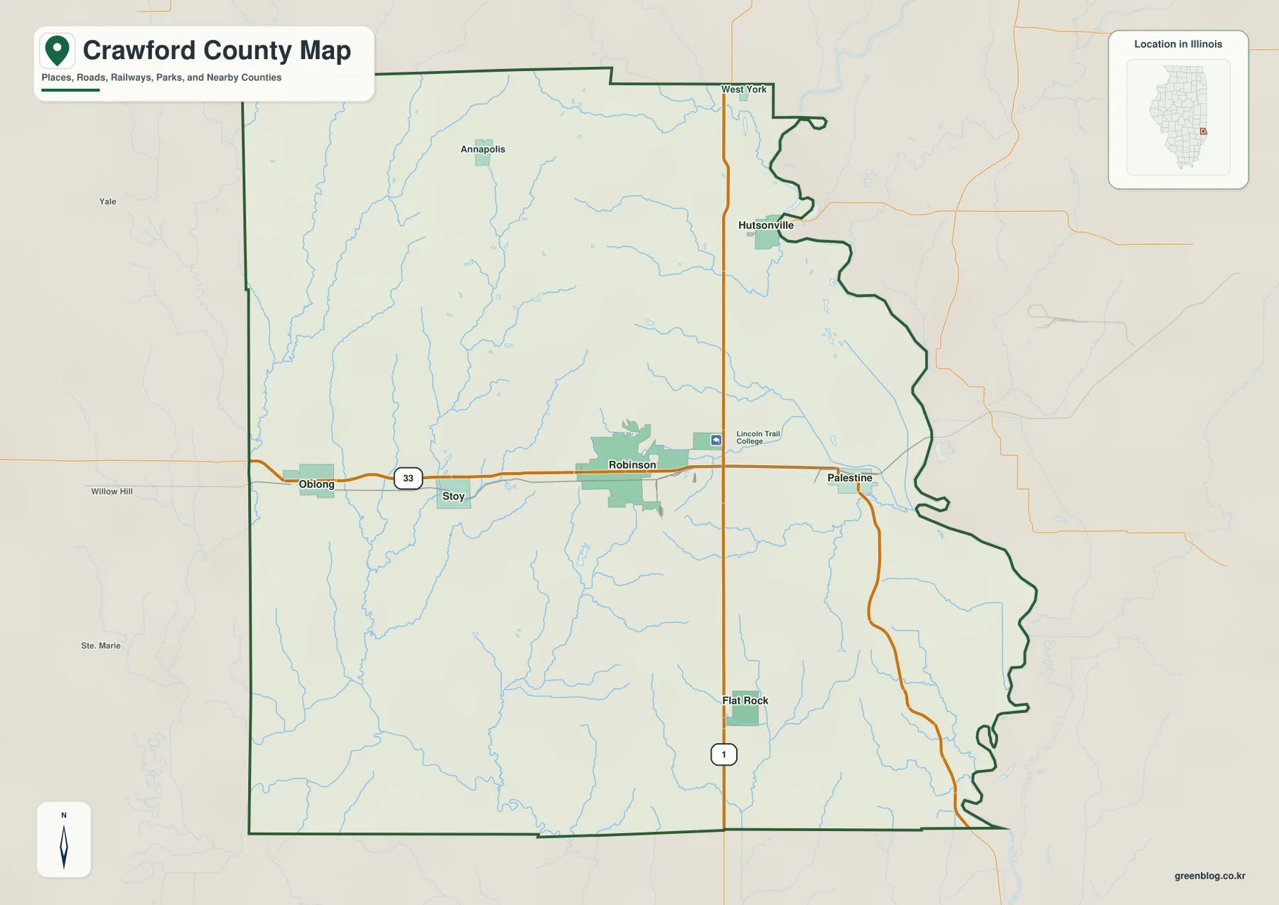
The blue drainage lines add a much more irregular pattern. Tributaries approach Robinson from the west and south, and several long creeks descend through the Oblong side of the county. The eastern boundary bends sharply around the Hutsonville-Palestine side, unlike the straighter western edge. Roads make the county look orderly; the stream network reveals a landscape divided by many valleys and short ridges.
Robinson replaced Palestine as the county seat in 1843
Illinois State Archives lists Palestine as the county seat from 1818 through 1843 and Robinson from 1843 to the present. That makes the Route 33 connection between the two towns more than a simple road relationship. Robinson is the current administrative center, while Palestine represents an earlier seat on the eastern side of the county.
Six city markers show a long east-west county
The simplified city graphic ranks Robinson first, Oblong second, Palestine third, Hutsonville fourth, Flat Rock fifth, and Stoy sixth. Its printed CITY INDEX lists 7,084 for Robinson, 1,643 for Oblong, 1,430 for Palestine, 590 for Hutsonville, 337 for Flat Rock, and 90 for Stoy. The year or statistical reference behind those values is not displayed on the image.
Because the index is undated, the figures are not presented here as current population counts. Their placement is still helpful. Robinson sits near the center, Oblong is to the west, Palestine to the east, Hutsonville well to the northeast, and Flat Rock to the south. Stoy fills the gap between Oblong and Robinson along the central road corridor.
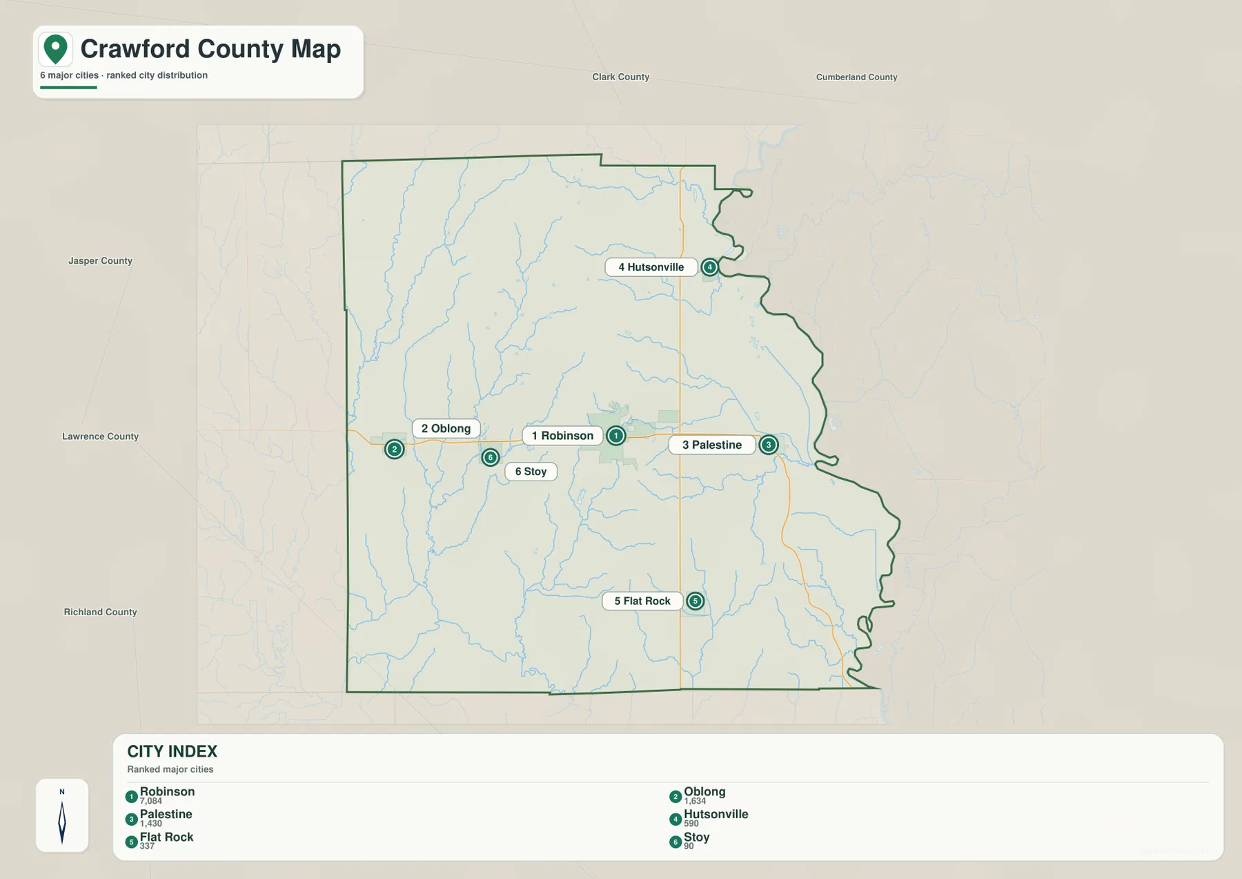
Removing most road detail makes the county’s shape easy to remember. Oblong, Stoy, Robinson, and Palestine form the main horizontal sequence, while Hutsonville and Flat Rock extend the pattern north and south along the eastern half. Once that simple arrangement is familiar, the detailed road and water sheets are easier to use without losing orientation.
The CITY INDEX is not a current population table
Current population work should use a dated source such as the U.S. Census Bureau. The supplied city graphic does not identify the reference year for its index values. On this page, those numbers are used only to describe the ranking printed on the map and the relative prominence of the six selected communities.
Embarras River and western creeks cut the low valleys
Embarras River is the strongest named water feature on the terrain map, appearing along the southwestern edge. Above it, Muddy Creek and Dogwood Creek form long north-south drainage lines in the western half. Big Creek and Little Creek occupy nearby valleys, adding several parallel low corridors between the higher ridges.
Oblong Lake is labeled near the western-middle county, with West Lake and Brooks Lake farther east. Honey Creek descends through the central-southern area. On the eastern side, Sugar Creek and Lamotte Creek form long branches, while No Business Creek and Brush Creek appear in the southeast. Lake Walton provides a small water reference close to the northeastern edge.
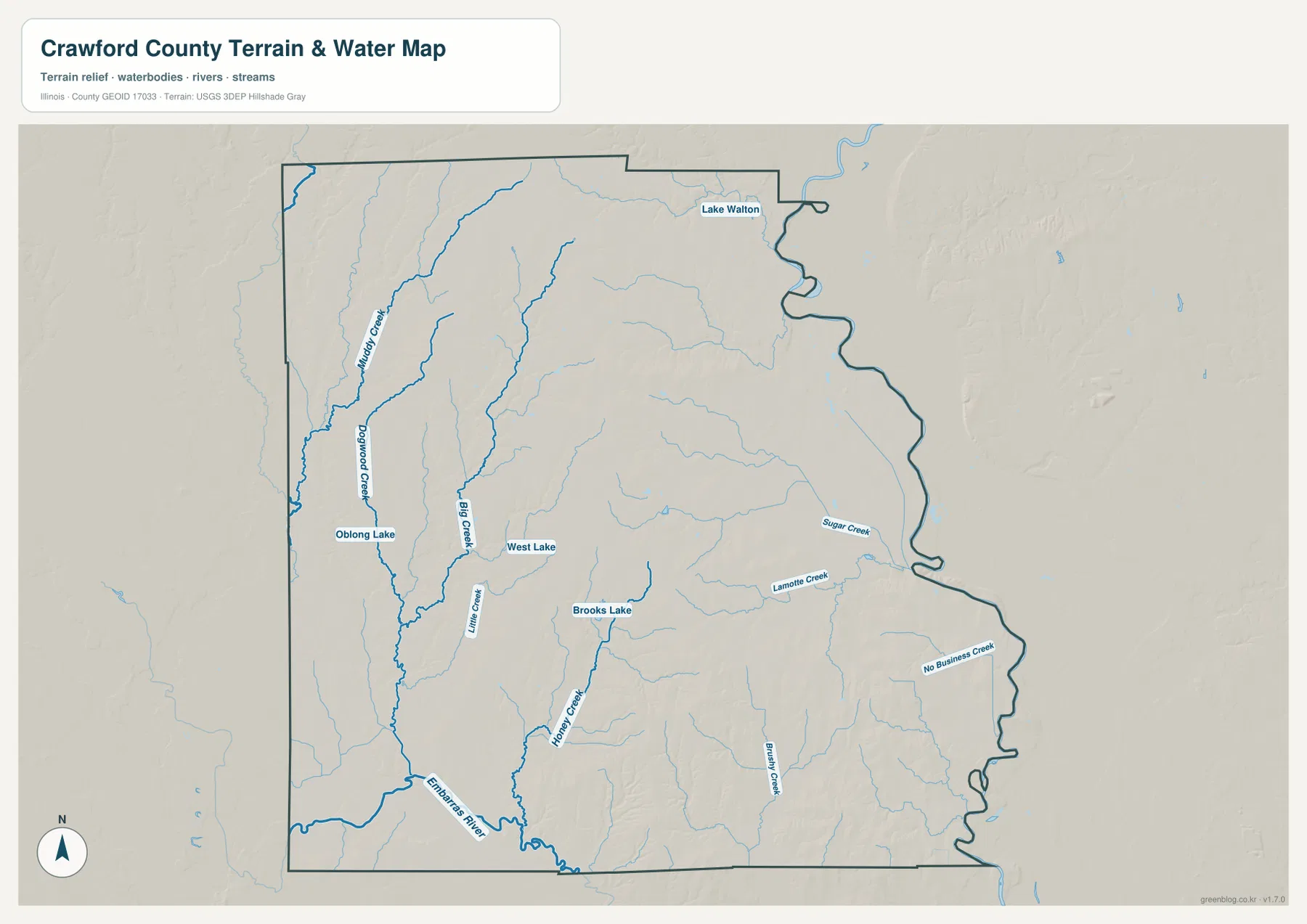
A local protected area adds useful context to the northern part of the county. Illinois DNR describes Crawford County Fish and Wildlife Area near Hutsonville as a rolling landscape bisected by Hutson Creek, with bottomland forest, wetlands, ponds, and mature oak-hickory woodland. That description fits the broader map impression of northern and eastern Crawford County as a landscape of gentle uplands separated by creek valleys.
A water map does not show current river or flood conditions
The terrain sheet locates rivers, creeks, lakes, and surrounding relief at county scale. It does not report current Embarras River stage, flood-hazard boundaries, water depth, boating or fishing rules, or legal access. Current USGS, Illinois DNR, and other responsible-agency information should be used when the question depends on present conditions or safety.
North-central and southeastern ridges rise above the stream lowlands
The elevation image gives Crawford County a strong patchwork of ridges and low valleys. Brown and orange high ground is prominent north of Robinson and across parts of the southeast. A shorter east-central ridge stands out as well. In contrast, the southwestern Embarras side and several western creek valleys appear in green, marking the lower terrain.
The map prints an actual countywide elevation range of about 126 to 194 meters and a mean near 153 meters. Its legend uses narrower bands from roughly 131 to 177 meters, while the separate “Actual” line records the full minimum and maximum of the dataset. Those endpoints describe Crawford County as a whole and should not be assigned directly to Robinson, Palestine, Oblong, or any single property.
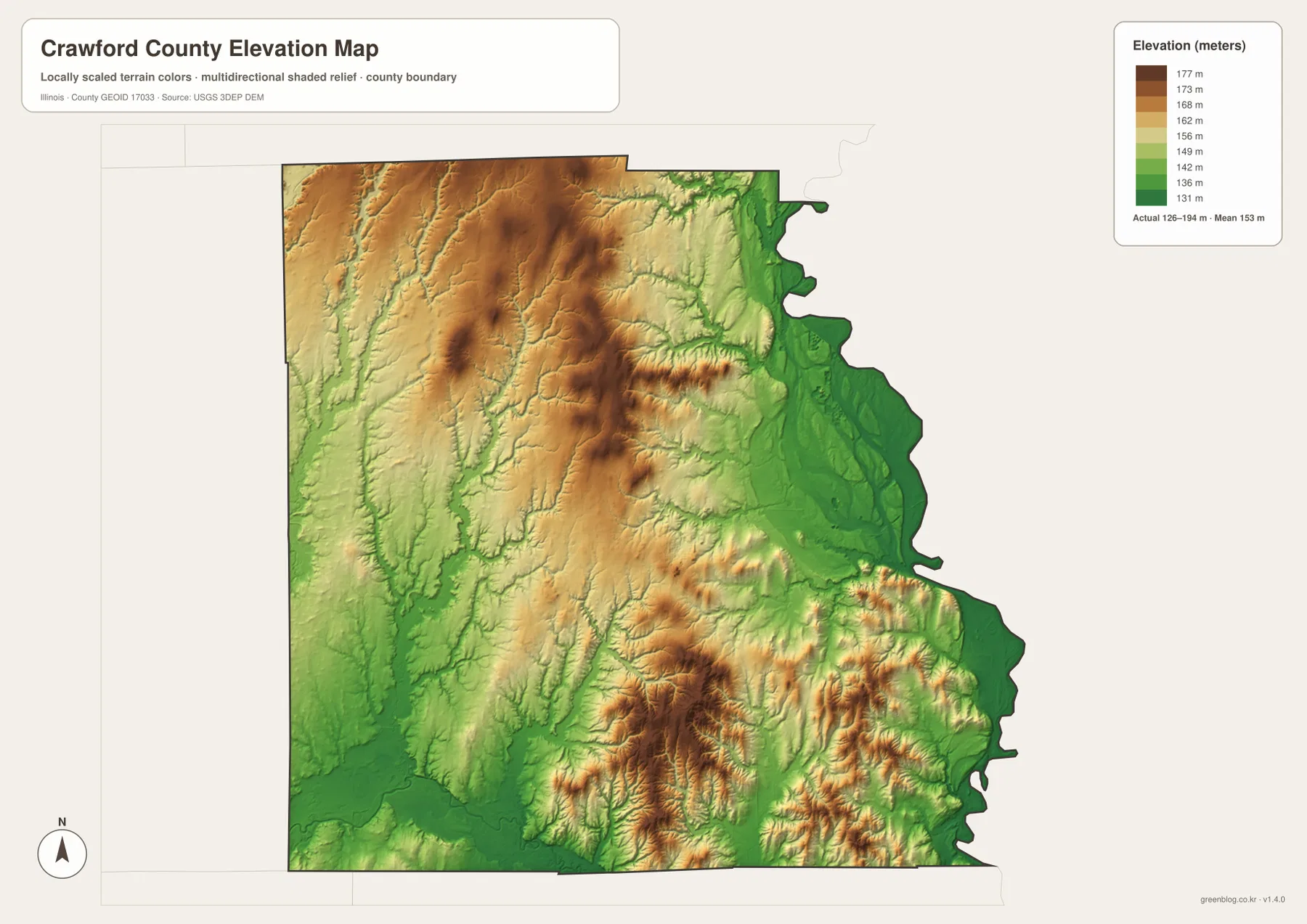
Comparing the water and elevation views makes the low green corridors easier to interpret. Muddy Creek, Dogwood Creek, Big Creek, Honey Creek, and Embarras River all follow terrain below nearby ridges. The southeast is more broken, with short high ridges separated by narrow drainage cuts. That difference explains why the road map can look simple even though the underlying relief is fairly intricate.
126 to 194 meters is a countywide range
A building site, road grade, drainage plan, or parcel needs point-specific elevation data or a professional survey. The 126–194 meter range is best used to compare Crawford County’s creek lowlands and surrounding uplands, not to assign an exact elevation to a town or street address.
Keep Robinson fixed while switching between roads, water, and relief
A practical way to use the files is to hold Robinson in the center while changing layers. Start on Route 33 and memorize Oblong, Stoy, Robinson, and Palestine from west to east. Add Hutsonville and Flat Rock along the Route 1 side. The city graphic then confirms that simple arrangement without the smaller roads and drainage lines.
Next, move to the terrain sheet and trace the western creeks toward Embarras River. When the elevation colors are added, those stream corridors become visibly lower than the neighboring ridges, especially in the western and southwestern county. Higher terrain north of Robinson and across the southeast completes the picture. Using the same place references across all sheets keeps the settlement pattern, drainage, and relief connected.
Use current transportation sources for driving conditions, dated Census data for population, water agencies for river or flood questions, and point-level elevation or survey data for site work. Within those limits, the Crawford County maps are useful for printed references, lessons, presentations, and advance geographic orientation.
Frequently Asked Questions
What is the county seat of Crawford County, Illinois?
Robinson is the current county seat. Illinois State Archives records Palestine as the seat from 1818 to 1843 and Robinson from 1843 to the present. Crawford County’s current government offices are also based in Robinson.
Where is Embarras River on the supplied map?
Embarras River is labeled near the southwestern edge of Crawford County. Several western drainage lines, including Muddy Creek, Dogwood Creek, Big Creek, and Little Creek, descend toward the lower southern part of the county around that river system.
Does 126 to 194 meters give Robinson’s elevation?
No. The elevation image identifies 126–194 m as the actual range across the Crawford County dataset and gives a mean of about 153 m. Exact elevation for Robinson or any specific road, building, or property requires point-specific elevation or survey data.
Sources and Reference Material
The article uses the supplied Crawford County maps together with the official references below. For current road conditions, river stages, wildlife-area rules, legal boundaries, or exact point elevations, consult the responsible agency’s latest material rather than relying on a static county reference map.
- Crawford County Official Website – county establishment and current county-government information in Robinson
- Illinois State Archives – Crawford County – county establishment, name origin, and Palestine-Robinson county-seat history
- Illinois DNR – Crawford County Fish and Wildlife Area – rolling terrain, Hutson Creek, bottomland forest, wetlands, and ponds near Hutsonville
- USGS National Hydrography – river, stream, and lake reference data
- USGS 3D Elevation Program – elevation and terrain data
Map File Information
The ZIP file contains the high-resolution JPG originals for the Crawford County overview, city map, terrain-and-water map, and elevation map. Each landscape image measures 3,638 × 2,572 pixels, preserving Route 33 town labels, smaller creek names, and elevation colors more clearly when enlarged or printed.
- Included Files: 4 high-resolution JPG maps
- Printable Size: 3,638 × 2,572 pixels each
Related Maps
Green Map creates custom-edited map images using open geographic data sources such as geoBoundaries, Natural Earth, OpenStreetMap, and government open data.
These maps are edited visual materials, not raw data files, and are provided for education, documents, presentations, and graphic reference.