Franklin County sits in western Arkansas where the Arkansas River cuts across the middle of the county and creates a clear divide between two very different landscapes. Ozark, Altus, Denning, and Wiederkehr Village lie on or north of the river, backed by steep ridges and narrow valleys, while Charleston and Branch sit in the lower, more open country to the south. This page brings those places together with roads, waterways, and elevation so you can understand the county at a glance. The same four maps are also available as high-resolution JPG files in one downloadable ZIP.
One unusual feature becomes obvious as soon as Ozark and Charleston are located on the map: Franklin County has two county seats. The Encyclopedia of Arkansas explains that the Arkansas River historically divided access between the northern and southern parts of the county, which eventually led to separate court districts. Ozark serves the northern district and Charleston the southern district. Their separation is more than a historical detail; it is a useful way to understand the county’s road network and the strong contrast between the mountainous north and the gentler land south of the river.
Table of Contents
Start with Ozark and Charleston to understand the county
Ozark is the easiest reference point for the northern half of Franklin County. Interstate 40 and U.S. 64 run east-west near the city, while Arkansas Highway 23 heads north into the hills and south toward the river crossing. The city occupies a bend of the Arkansas River, so the map shows a close relationship between the town, the river corridor, and the roads climbing toward the northern uplands. Once Ozark is located, the positions of Altus, Wiederkehr Village, and Denning to the east become much easier to follow.
Charleston lies well to the southwest on the opposite side of the Arkansas River. Highway 22 crosses the area from east to west, and Branch appears to the northeast along roads that connect the southern rural communities. The broad separation between Ozark and Charleston helps explain why one city does not function as a simple geographic center for the whole county. The river and the surrounding terrain divide travel into different corridors, and the basic map makes that arrangement much clearer than a list of place names would.
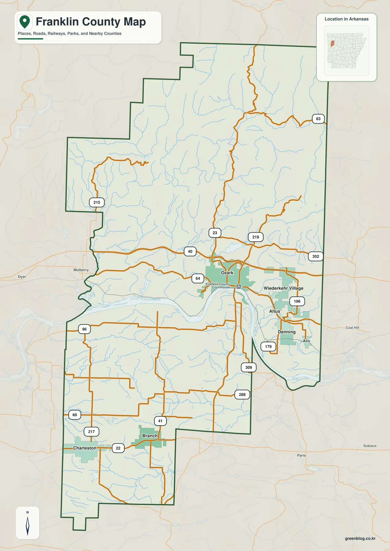
East of Ozark, Altus, Wiederkehr Village, and Denning form a compact group compared with the widely separated communities in the southern half. Highways 186 and 179 serve this area, while Highway 352 continues toward the eastern county line. North of Ozark, Highway 23 and the routes farther west and east become noticeably more winding as they enter rougher terrain. Highway 215 reaches into the northwestern highlands, and Highway 83 appears near the northeastern side. The road shapes themselves give a quick visual clue that the northern part of the county is much more rugged.
Six major communities are split across the river corridor
The city map ranks six communities: Ozark, Charleston, Altus, Branch, Denning, and Wiederkehr Village. Ozark is shown as the leading city, followed by Charleston, with the other four settlements considerably smaller. Their locations matter more than the ranking itself. Ozark and the three eastern communities are grouped near the Arkansas River and the northern side of the county, while Charleston and Branch sit well to the south. This arrangement shows that Franklin County does not have one continuous urban strip; its population centers are separated by the river and large rural areas.
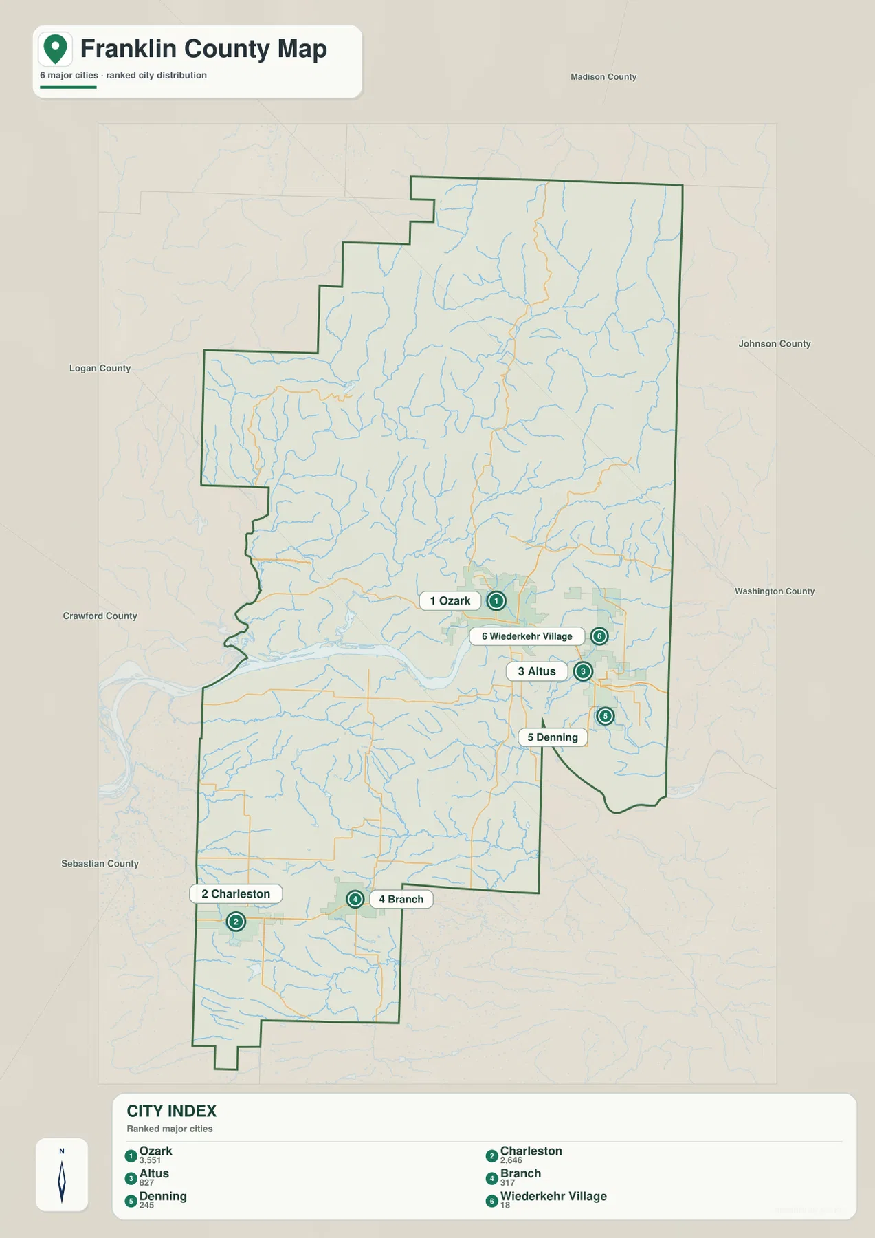
From Ozark, the cluster around Altus and Wiederkehr Village lies to the east, with Denning farther southeast. Crossing the river and moving south leads into a much broader area before Branch and Charleston appear. The city map does not provide driving distances or straight-line mileage, so it is best used to understand direction and distribution rather than travel time. For a trip between these communities, a current navigation map should be used alongside this county overview.
Combining the city and road maps adds another layer of useful context. Ozark is tied closely to I-40, U.S. 64, and Highway 23, while the Altus area is served by routes such as 186 and 179. Charleston is organized around Highway 22, and Highway 41 helps connect the Branch area with roads farther north and south. Instead of memorizing every route number, follow each road from the nearest named community. That approach makes the county easier to understand and keeps the map useful even when you are unfamiliar with western Arkansas.
The Arkansas River separates mountain country from lower farmland
The Arkansas River is the dominant water feature in Franklin County. It enters from the west, crosses the county near Ozark, and bends eastward through the broad central corridor. The Encyclopedia of Arkansas describes the county as divided by the river into a forested northern section and a southern section where farmland is much more common. That contrast is visible across all four maps: the river marks the transition from steep, closely spaced ridges in the north to lower and more open terrain south of the channel.
North of the Arkansas River, the Mulberry River is the most prominent tributary shown on the terrain and water map. Rivers.gov notes that the Mulberry begins in the Boston Mountains, flows through Newton, Johnson, and Franklin counties, and eventually joins the Arkansas River. Within Franklin County, its winding course follows deep valleys through the northern uplands. Numerous small streams feed into it from surrounding ridges, which gives the northern half of the water map a dense network of blue lines.
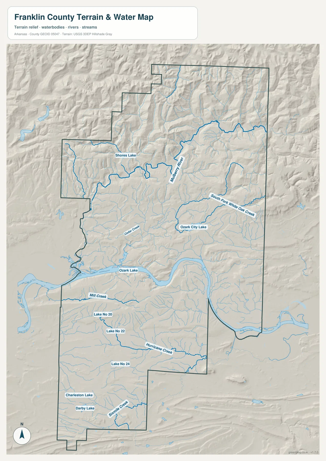
Shores Lake appears in the northwest, and Ozark City Lake is labeled farther southeast in the northern half. South Fork White Oak Creek crosses the northeastern area, while Cedar Creek is visible closer to Ozark. South of the Arkansas River, Mill Creek and Hurricane Creek are among the longer named streams, and Charleston Lake, Darby Lake, and Sixmile Creek appear near the southwestern communities. Several smaller impoundments are labeled Lake No 20, Lake No 22, and Lake No 24. Together these features show that water is distributed throughout the county even though the largest river dominates the center.
This water map is intended for general geographic reference, not for judging current river stage, flood risk, water quality, fishing regulations, or property boundaries. Conditions on the Arkansas and Mulberry rivers can change with weather and upstream releases. Anyone planning river recreation or making a safety decision should check current information from the appropriate agency. The map is most useful for identifying where named rivers, creeks, and lakes sit in relation to the county’s roads and terrain.
Elevation rises from about 103 meters to 734 meters
The elevation map gives Franklin County an unusually strong north-south contrast. The displayed range is about 103 to 734 meters, with a mean of about 253 meters. That is a difference of roughly 631 meters within one county. The Arkansas River corridor and most of the land around Charleston and Branch appear in green, indicating lower elevations. North of the river, colors quickly shift through yellow and brown as ridges rise toward the Boston Mountains.
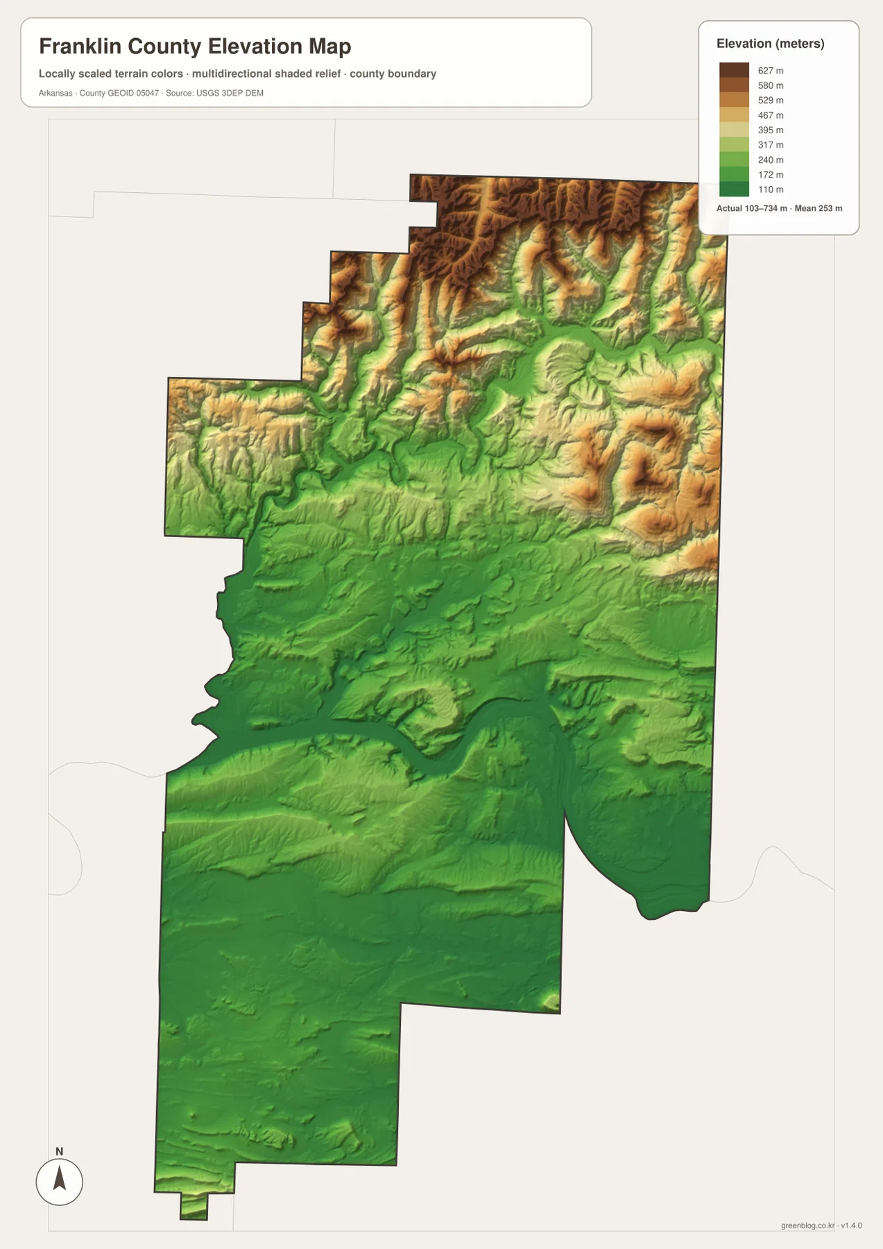
The roughest relief is concentrated across the northern and northeastern portions of the county, where narrow valleys cut between closely spaced ridges. The pattern aligns with the water map, where the Mulberry River and many small tributaries occupy those valleys. By contrast, the southern half has broader stretches of lower terrain and fewer tightly packed ridges. The difference also helps explain why roads such as Highway 23 and Highway 215 become more winding as they climb northward from the river corridor.
The Encyclopedia of Arkansas describes the Boston Mountains as the highest and most rugged part of the Ozarks and specifically notes Highway 23 in Franklin and Madison counties as one of the winding routes crossing this landscape. That description matches the county map and the elevation colors well. Still, the elevation image is designed to compare large areas rather than provide survey-grade heights for individual parcels, bridges, or roads. For engineering, construction, or precise site elevations, the original USGS 3D Elevation Program data or a professional survey should be used.
Use the maps together when exploring the northern highlands
A practical way to read the northern half is to begin at Ozark and follow Highway 23 toward the higher terrain. The river valley is relatively low, but the land soon breaks into ridges and narrow drainages. Farther north, the Mulberry River crosses the mountain landscape, while Highway 215 leads toward the Shores Lake area in the northwest. On the northeastern side, Highway 83 and smaller roads thread through another series of high ridges and valleys. Switching between the road, water, and elevation views makes those relationships much easier to see.
The southern half can be read in a different way. Start with Charleston and Branch, then compare the straighter road network with Mill Creek, Hurricane Creek, and the lower elevation colors. This part of the county lacks the dense wall of mountain ridges found north of the Arkansas River, so communities and roads sit in a more open landscape. The difference is one of the clearest examples in Arkansas of how a major river corridor can sit between two distinct local landscapes within the same county.
Choosing the best file for printing and close inspection
The WebP images in the article are sized for quick viewing on the web. The download package contains the same four maps as 2572 × 3638 pixel JPG files, which are suitable for large on-screen viewing and A3-proportion printing. Use the general county map when roads and communities are the priority, the city map for a simpler comparison of major settlements, the terrain and water map for named rivers and lakes, and the elevation map when the difference between the river valley and northern mountains matters most.
These files work well for classroom reference, travel planning, presentations, personal printing, and general orientation. They should not replace legal boundary records, parcel surveys, engineering maps, flood studies, or live navigation. When exact or current information is required, consult sources such as Census TIGER/Line boundaries, USGS hydrography, USGS elevation data, and the responsible local or federal agency.
Frequently Asked Questions
Why does Franklin County have two county seats?
Ozark and Charleston both serve as county seats. The Arkansas River historically made travel between the northern and southern parts of the county difficult, so separate court districts developed on opposite sides of the river. The map makes that separation easy to see, with Ozark on the north side and Charleston well to the southwest.
Where is the highest terrain in Franklin County?
The highest terrain on this map is north of the Arkansas River, especially across the northern and northeastern highlands. The displayed elevation range is approximately 103–734 meters with a mean near 253 meters. The Charleston and Branch area in the south is much lower and appears mostly in green on the elevation map.
Do the numbers on the city map show distances?
No. The numbers rank the six major communities shown on the map: Ozark, Charleston, Altus, Branch, Denning, and Wiederkehr Village. They are not mileage values. Use a current road or navigation map if you need driving distance or travel time between the cities.
Map File Information
Franklin County map files
- File Type: ZIP containing 4 JPG files
Related Maps
Sources and references
- Encyclopedia of Arkansas – Franklin County – county geography, history, the Arkansas River divide, and dual county seats
- Rivers.gov – Mulberry River – information about the Mulberry River and its route through the Boston Mountains
- U.S. Forest Service – Recreation Destinations – federal recreation information including the Ozark-St. Francis National Forest region
- U.S. Census Bureau TIGER/Line Shapefiles – county boundary and road data
- USGS National Hydrography – rivers, streams, and waterbody data
- USGS 3D Elevation Program – elevation and terrain data
Green Map creates custom-edited map images using open geographic data sources such as geoBoundaries, Natural Earth, OpenStreetMap, and government open data.
These maps are edited visual materials, not raw data files, and are provided for education, documents, presentations, and graphic reference.