Nash County Map visitors can use this page to locate Nashville, Rocky Mount, Red Oak, Spring Hope, Sharpsburg, Dortches, and the smaller communities shown around the county. The article includes a general county map, a city-location map, and a terrain-and-water map, and the same map set is available as high-resolution A3 JPG files in one ZIP download. The web previews are useful for quick orientation, while the larger downloadable originals are better for printing, study, or close inspection of labels and linework.
Nashville is identified in the package material as the county seat, while Rocky Mount forms the most prominent urban area on the eastern side of the maps. The existing article also notes that Rocky Mount extends across the Edgecombe County line, so a visitor should not assume that the full visible city footprint lies inside Nash County. West and southwest of Nashville, places such as Spring Hope, Middlesex, Bailey, and Momeyer are more widely spaced, creating a very different settlement pattern from the eastern side.
Table of Contents
Nashville and Rocky Mount serve different map purposes
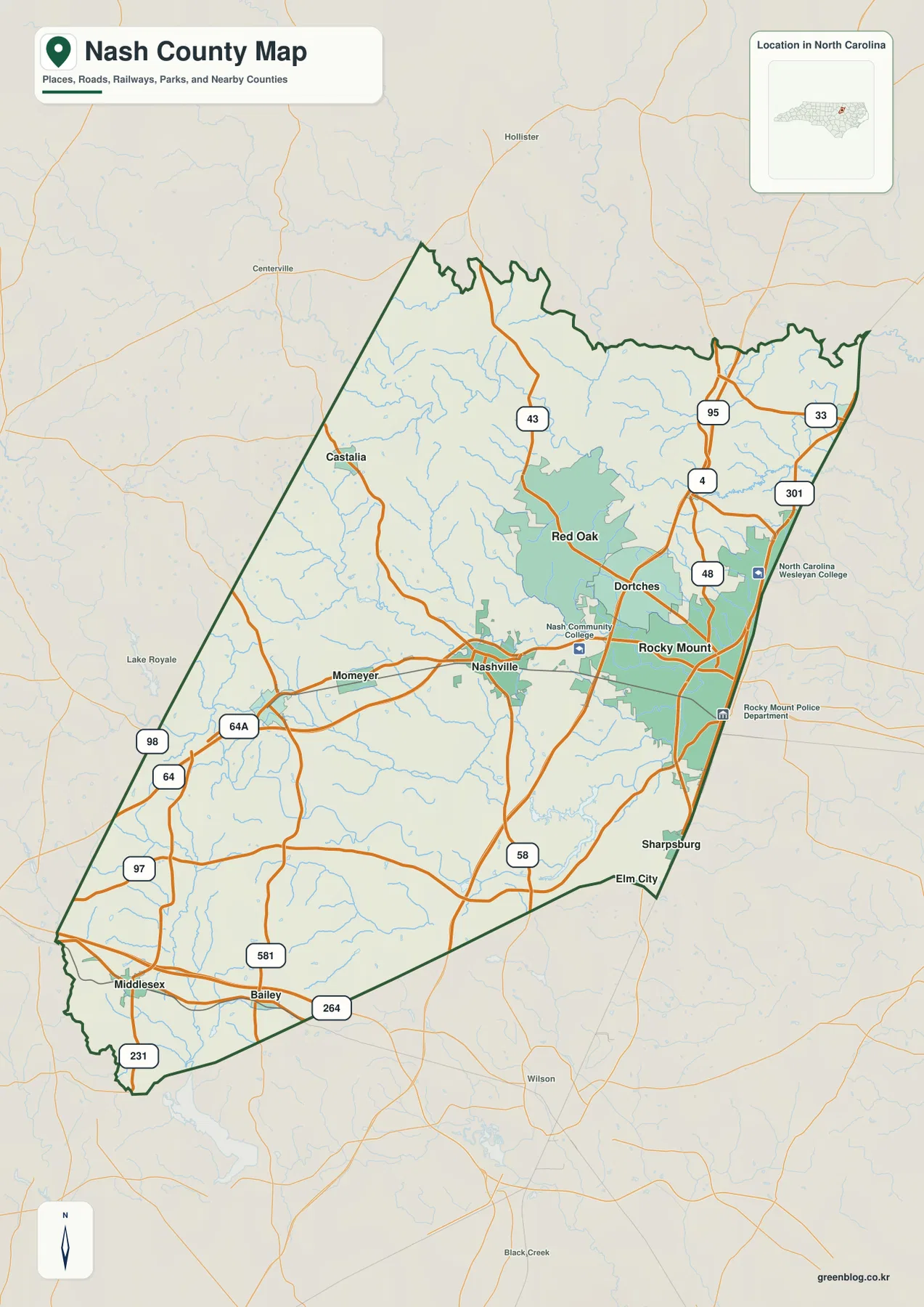
On the general county map, Nashville appears slightly southeast of the county’s center, while Rocky Mount occupies a much broader developed area farther east. Dortches lies between the two, and Red Oak is positioned to the north. These locations make Nashville a useful central reference, but Rocky Mount is the stronger visual landmark for the eastern side of the county.
The road network reinforces that difference. Routes 64 and 64A are easy to follow west of Nashville, while the Rocky Mount side has several numbered routes close together, including 4, 48, 95, and 301. Route 43 extends through the northern interior and Route 58 appears farther south, so the most useful highway reference changes depending on which part of Nash County you are trying to find.
Momeyer sits west of Nashville, and the map opens into a more rural-looking set of roads toward Spring Hope, Middlesex, and Bailey in the southwest. Castalia is a separate northwest reference rather than part of the Nashville-Rocky Mount cluster. Keeping these outer communities visible prevents the map from becoming an east-side city page instead of a county-wide guide.
The Rocky Mount side has the county’s densest visible road-and-city pattern
Rocky Mount is surrounded by the broadest developed shading on the general map, and several major road symbols sit nearby. Route 95 runs through the eastern side, Route 301 is farther east, and routes 4 and 48 provide additional local references. That concentration gives the eastern map a more urban appearance than the western half, where communities are smaller and more widely separated.
Sharpsburg appears near the southeastern edge, while Elm City is labeled outside the county boundary farther south and east. Because the labels are close to the dark county outline, it is important to read the boundary before assuming every nearby place lies inside Nash County. The same caution applies to Rocky Mount, whose urban footprint is described in the existing package material as extending into Edgecombe County.
The general map also marks North Carolina Wesleyan College and Nash Community College, which can be useful local reference points when comparing roads and urban areas. They are not the focus of this county guide, but their labels help break down the otherwise broad Nashville-Rocky Mount corridor. A more detailed street map would still be needed for turn-by-turn travel or address-level work.
The city map separates the eastern cluster from Red Oak, Spring Hope, and Sharpsburg
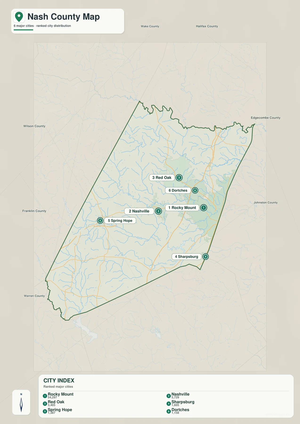
The city map highlights six major places: Rocky Mount, Nashville, Red Oak, Sharpsburg, Spring Hope, and Dortches. The markers are numbered Rocky Mount 1, Nashville 2, Red Oak 3, Sharpsburg 4, Spring Hope 5, and Dortches 6. Those numbers are best treated as the map’s provided city ranking rather than as an administrative hierarchy.
Rocky Mount and Dortches sit close together on the east side, while Nashville is farther west and works as the central county-seat reference. Red Oak is north of that corridor, Spring Hope is distinctly southwest, and Sharpsburg lies near the southeast boundary. With most road detail removed, the city map makes these directional differences much easier to compare than the general map.
Surrounding county names include Wake, Halifax, Edgecombe, Johnston, Franklin, and Wilson. These labels give the map regional context without turning it into a detailed neighboring-county study. Edgecombe is especially relevant to the Rocky Mount side because the existing article identifies the city as crossing the county line, a relationship that explains why the urban area and the Nash boundary do not perfectly match.
Tar River crosses the southern half and links a broad network of creeks
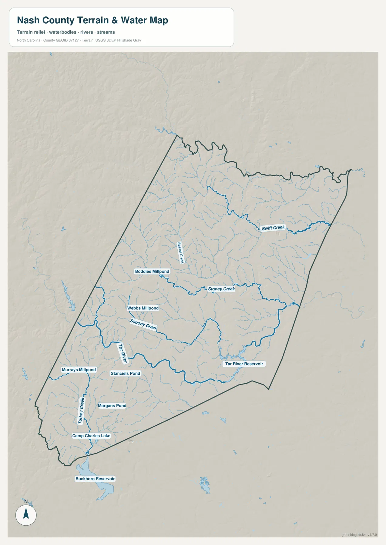
Tar River is one of the strongest physical references on the terrain-and-water map. It enters from the southwest, bends across the southern part of Nash County, and continues toward Tar River Reservoir in the east-central area. Removing roads and city shading makes the river easier to follow and shows how much of the southern county is organized around a connected drainage system.
North of Tar River, Sapony Creek and Stoney Creek follow separate courses across the interior. Stoney Creek runs a long distance through the middle of the county, while Swift Creek is a major named feature across the northeast. Basket Creek is labeled farther northwest. These waterways turn the northern and central map into a series of drainage corridors rather than one undivided inland block.
The water map is therefore useful for questions that the road map answers poorly. If you are trying to locate a named creek near Nashville, Rocky Mount, or one of the outer communities, the cleaner water view reduces visual competition from highways and place labels. Once the water feature is located, the general map can be used again to connect it with towns and roads.
Millponds and reservoirs provide detailed landmarks in the western and southern county
Boddies Millpond and Webbs Millpond are labeled in the west-central area, while Murrays Millpond lies farther southwest. Stancils Pond and Morgans Pond add smaller references in the south, and Camp Charles Lake appears close to the southwestern tip. These water bodies are much smaller than Tar River, but they can be valuable landmarks in parts of the county where town labels are sparse.
Tar River Reservoir is clearly labeled inside the southeastern part of the county, while Buckhorn Reservoir is shown outside the southern boundary. The dark county outline matters here because it prevents two nearby reservoir references from being treated as if they occupy the same jurisdiction. Reading the boundary first and then the water names is the safest way to use this map for county-level orientation.
Turkey Creek is another long named waterway in the southwest, surrounded by many smaller tributaries. The hillshade suggests low, gentle relief rather than steep mountain terrain, with streams following shallow valleys across the county. This physical pattern gives the water map a useful role even in places where the road network appears simple.
The southwest is easier to read by combining small towns with routes 64, 97, and 98
The western side of the general map uses a different set of road references from Rocky Mount. Route 98 is marked in the northwest, routes 64 and 64A cross the southwest toward Nashville, and Route 97 appears farther south. Routes 581 and 231 are also labeled in the lower western part of the county. Because there is no single large city covering this area, highway numbers and smaller place names become more important.
Middlesex and Bailey sit close to the southern boundary, Spring Hope lies farther north and is also included on the city map, and Momeyer is nearer to Nashville. Castalia provides a separate northwestern landmark. These communities make the western half easier to understand as a set of smaller centers rather than an extension of the Rocky Mount urban area.
The water map adds Sapony Creek, Tar River, Turkey Creek, and several millponds to the same part of the county. A useful approach is to locate the road or town first, then switch to the water view to see the nearby drainage feature. The three supplied maps are most effective when they are treated as complementary references instead of interchangeable copies.
Use the general map for roads, the city map for settlement comparison, and the water map for drainage detail
Start with the general county map when you need an all-purpose reference for Nashville, Rocky Mount, Red Oak, Castalia, Spring Hope, Middlesex, Bailey, numbered roads, and the county outline. It is also the best view for checking whether a nearby place label sits inside or outside the dark boundary before moving to a more detailed map.
The city map is cleaner when the main question is how Rocky Mount, Nashville, Red Oak, Sharpsburg, Spring Hope, and Dortches compare in position. Choose the terrain-and-water map when Tar River, Swift Creek, Stoney Creek, Sapony Creek, millponds, reservoirs, or gentle relief matter more than highways. Each view removes some information so a different part of the county becomes easier to read.
The downloadable ZIP contains high-resolution A3 JPG originals for the same general county map, city map, and terrain-and-water map shown on the page. The WebP images are optimized for browsing, while the JPG originals provide larger labels and linework for printing, classroom use, personal study, travel preparation, or offline reference. Preview the map you need first and use the ZIP when the larger original is more practical.
Frequently Asked Questions
Why should Nashville and Rocky Mount be treated as different map references?
The package identifies Nashville as the county seat, while Rocky Mount is the larger urban area on the eastern side. The existing article also states that Rocky Mount extends across the Edgecombe County line, so administrative center and urban footprint are not the same thing. The general map is most useful when the dark county boundary is read together with both city labels.
Which named waterways can I find besides Tar River?
The terrain-and-water map labels Swift Creek, Stoney Creek, Sapony Creek, Basket Creek, and Turkey Creek. It also shows Boddies Millpond, Webbs Millpond, Murrays Millpond, Tar River Reservoir, and Camp Charles Lake, making it the best supplied map for detailed water-feature searches.
What files are included in the downloadable ZIP?
The ZIP includes high-resolution A3 JPG files for the general Nash County map, the city map, and the terrain-and-water map. They match the three map types shown in the article but use larger originals than the browser previews, making them more suitable for printing or close inspection.
Sources and Reference Data
This article is based first on the maps, package notes, and validation material supplied for this Nash County rewrite. The following public sources provide additional county background, boundary data, and hydrography references.
Map File Information
This ZIP contains high-resolution A3 JPG versions of the Nash County general map, city map, and terrain-and-water map. The larger originals make Nashville, Rocky Mount, numbered roads, Tar River, Swift Creek, reservoirs, and millponds easier to inspect or print.
- Included Files: Use only the versions confirmed in the article and supplied images
- File Type: Use the confirmed download contents
- Intended Use: Printing, education, presentations, and map-based projects
Related Maps
Green Map creates custom-edited map images using open geographic data sources such as geoBoundaries, Natural Earth, OpenStreetMap, and government open data.
These maps are edited visual materials, not raw data files, and are provided for education, documents, presentations, and graphic reference.