New Hanover County Map visitors can use this page to move from Wilmington to Wrightsville Beach, Carolina Beach, and Kure Beach while comparing the county’s roads with the Cape Fear water system and the Atlantic coast. The article includes a general county map, a city-location map, and a terrain-and-water map. The same map set is available as high-resolution A3 JPG files in one ZIP download, so the web previews work well for quick orientation while the larger originals are better for printing and close reading.
New Hanover County is long and narrow, with major water on both sides of much of the county. Wilmington occupies the western urban side near the Cape Fear system, while the Atlantic-facing communities lie east and south. Farther north, Castle Hayne, Wrightsboro, Kings Grant, Murrayville, Ogden, and Porters Neck add a different suburban and creek-filled landscape. The map therefore makes more sense when towns, roads, river channels, tidal creeks, and ocean inlets are considered together rather than treating Wilmington as the whole county.
Table of Contents
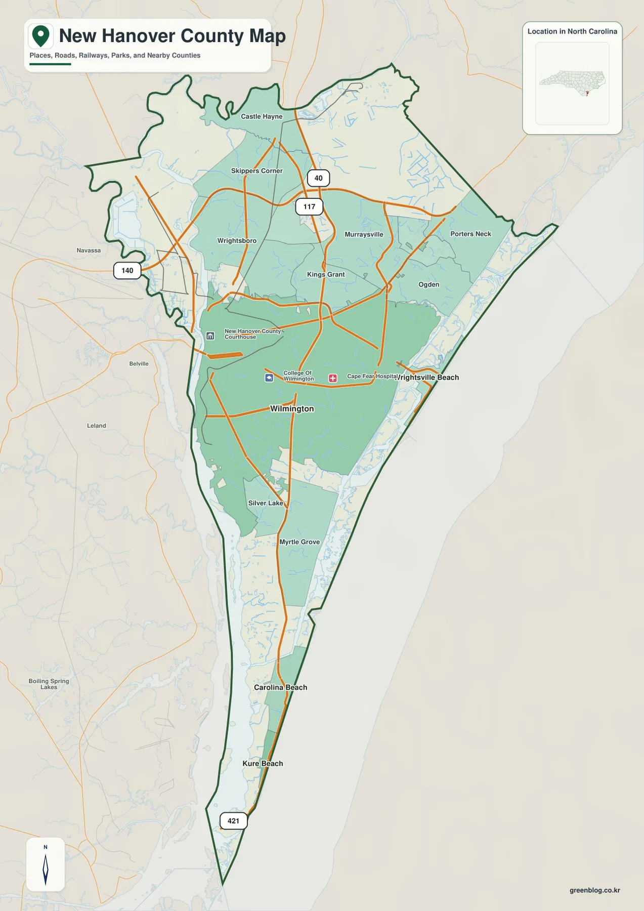
Wilmington is the road anchor, but the county stretches far beyond the city center
The general map makes Wilmington the easiest first reference. The New Hanover County Courthouse is marked on the western side of the city area, and the road network spreads north, east, and south from there. Kings Grant, Wrightsboro, and Skippers Corner appear farther north, with Castle Hayne near the northern end. Murrayville, Ogden, and Porters Neck occupy the northeastern side, showing that the county’s developed area continues well beyond central Wilmington.
Route shields for 40 and 117 appear on the northern approach, while 140 is marked near the western side and 421 continues along the long southern direction. These numbers provide simple map anchors: 40 and 117 help with the north, 421 helps with the southern beach corridor, and 140 helps locate the western edge. The exact local street pattern is more detailed than this county map needs to show, but the major routes are enough to establish the main travel directions.
South of Wilmington, Silver Lake and Myrtle Grove form useful intermediate references before the map narrows toward Carolina Beach and Kure Beach. Wrightsville Beach, by contrast, lies east of Wilmington rather than down the long southern corridor. That difference is important for anyone who sees all three beach communities grouped together in a regional search and assumes they occupy the same part of the county.
Wrightsville Beach and the southern beach towns occupy different coastal directions
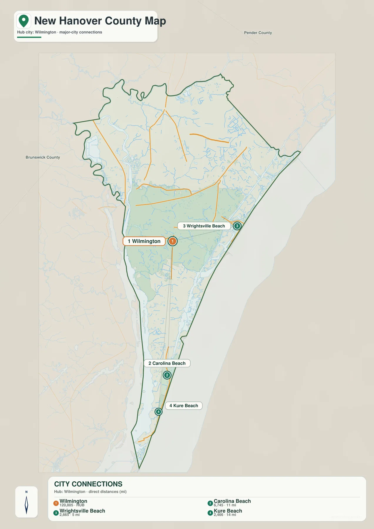
The city-location map strips away much of the place detail and highlights four major locations. Wilmington is number 1 on the western side of the county, Carolina Beach is number 2 in the south, Wrightsville Beach is number 3 on the eastern Atlantic edge, and Kure Beach is number 4 farther south below Carolina Beach. The numbered positions make the county’s shape easier to understand than a simple list of beach names.
Wrightsville Beach is the direct eastern coastal reference from the Wilmington area. Carolina Beach and Kure Beach belong to the long southern section, where the strip of land narrows between inland water and the Atlantic. A traveler moving to Wrightsville Beach is therefore using a different county direction from someone heading to Carolina Beach or Kure Beach, even though all three places are oceanfront communities.
Pender County is labeled to the north and Brunswick County to the west on the city map. Those labels provide broad regional context. Because New Hanover is strongly shaped by water boundaries, the neighboring-county relationship is easier to understand when the river and ocean sides are kept in mind instead of looking only at a conventional county outline.
The western side is organized by the Cape Fear system and North East Cape Fear River
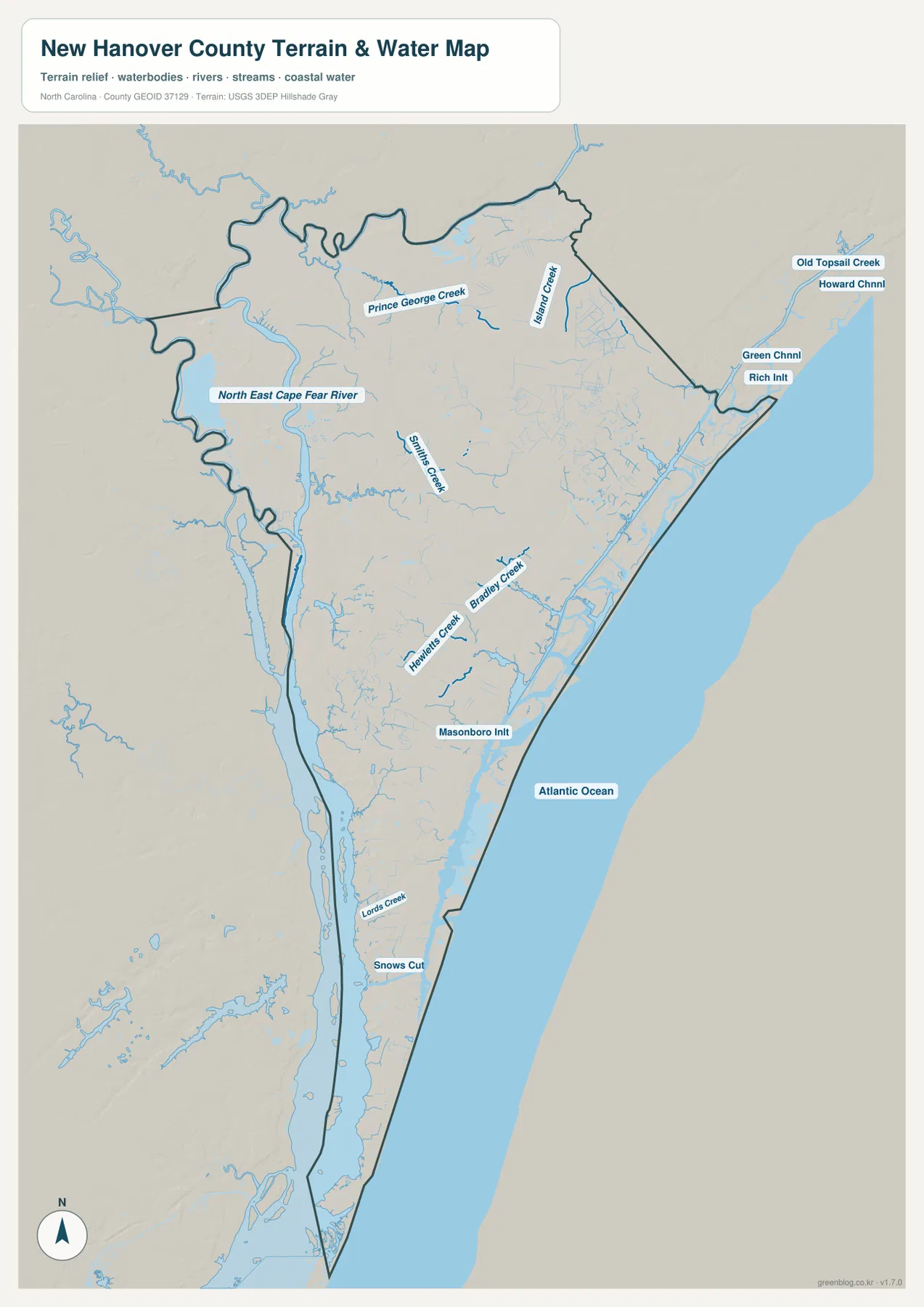
The terrain-and-water map makes the western water system much more prominent. A broad river corridor follows the west side of the county, and North East Cape Fear River is labeled in the northwest. Wilmington sits close to this river side, which is an important distinction from the Atlantic beach communities. Switching from the road map to the water map makes it clear that Wilmington’s geographic setting is tied to both a major river system and the coast.
Several northern creeks add detail to the river side. Prince George Creek and Island Creek are labeled in separate northern drainage areas, while Smiths Creek extends through the north-central and western interior. These waterways help organize places such as Castle Hayne, Wrightsboro, and Kings Grant when the road network is removed from view.
The dark county outline is especially useful here because some water features run close to the boundary and continue beyond it. A creek or river visible on the map should not automatically be treated as a feature entirely contained within New Hanover County. Reading the boundary first, then following the named waterways, makes the physical geography easier to interpret.
Atlantic inlets and tidal creeks give the eastern coast a much more detailed shape
The Atlantic Ocean is the dominant reference along the east, but the water map shows that the shoreline is not a simple straight edge. Old Topsail Creek, Howard Channel, Green Channel, and Rich Inlet are labeled in the northeastern coastal area. Around Porters Neck and Ogden, these channels and small waterways reveal a complex transition between mainland, tidal water, and the ocean-facing shore.
Closer to Wilmington, Hewletts Creek and Bradley Creek extend toward the coastal waterway. They provide useful physical references for the area between the city and Wrightsville Beach. South of that section, Masonboro Inlet marks another break in the coastal barrier, which helps explain why the Wilmington-Wrightsville area and the Carolina Beach corridor are separated by more than road distance.
Farther south, Lords Creek and Snows Cut are labeled near the narrowing lower county. Snows Cut is particularly useful for locating the water transition north of Carolina Beach. From there the map continues through the narrow coastal strip toward Kure Beach, with the Atlantic on the east and inland water on the west.
The southern county narrows between inland water and the Atlantic
The county outline becomes noticeably narrower south of Myrtle Grove. By the time the map reaches Carolina Beach and Kure Beach, the land is a long coastal strip with major water on both sides. This physical shape matters more than a conventional east-west county grid, because water controls the available directions of travel and makes the southern communities read as a linear coastal corridor.
The hillshade is subtle. New Hanover is not a mountain county, and the map does not show dramatic relief. Instead, low coastal terrain is cut by creeks, marshy drainage, inlets, and channels. For this county, the density and arrangement of water are more informative than large elevation differences, so the terrain map is most useful when read as a coastal-water map with gentle relief in the background.
The north should not be treated as simple mainland either. Small waterways spread around Castle Hayne, Porters Neck, and the northeastern edge, while Rich Inlet and nearby channels show a complicated coastal environment far from the southern beach towns. Separating the northeastern tidal coast from the Carolina Beach-Kure Beach corridor produces a more accurate county picture.
Choose the view according to whether you need roads, city positions, or coastal water detail
Start with the general county map when you need Wilmington, the northern communities, Wrightsville Beach, Carolina Beach, Kure Beach, major roads, and the county outline in one view. It is the best map for understanding the long north-south form of New Hanover County and for seeing how Wilmington connects to both the eastern beach direction and the southern beach corridor.
Use the city map when the main question is simply where the four highlighted communities sit relative to one another. It quickly separates east-side Wrightsville Beach from the southern Carolina Beach-Kure Beach pair. Choose the terrain-and-water map when you need North East Cape Fear River, Smiths Creek, Hewletts Creek, Bradley Creek, Masonboro Inlet, Snows Cut, Rich Inlet, or other named water features.
The downloadable ZIP contains high-resolution A3 JPG originals for the same general county map, city map, and terrain-and-water map shown in the article. The WebP images are optimized for browsing, while the JPG originals make small labels, channel names, and coastline detail easier to inspect. They are suitable for printing, classroom use, travel planning, personal study, or offline reference.
Frequently Asked Questions
How should Wrightsville Beach be distinguished from Carolina Beach and Kure Beach?
Wrightsville Beach is east of Wilmington on the Atlantic side, while Carolina Beach and Kure Beach lie in the long southern coastal section. The city map makes that directional difference clear, and the general map can then be used to trace the road connections from Wilmington to each beach area.
Which named waterways can I find besides the main Cape Fear system?
The terrain-and-water map labels North East Cape Fear River, Prince George Creek, Island Creek, Smiths Creek, Hewletts Creek, Bradley Creek, Masonboro Inlet, Snows Cut, Old Topsail Creek, and several coastal channels. It is the most useful map when detailed water geography matters more than road or city labels.
What files are included in the downloadable ZIP?
The ZIP includes high-resolution A3 JPG files for the general New Hanover County map, the city map, and the terrain-and-water map. They match the map types shown on the page but use larger originals than the browser previews, making them better for printing and close inspection of small road, creek, and coastal labels.
Sources and Reference Data
This article is based first on the maps and validation material supplied in the rewrite package. The following public sources provide additional county background, boundary data, and hydrography references.
Map File Information
This ZIP contains high-resolution A3 JPG versions of the New Hanover County general map, city map, and terrain-and-water map. The larger originals make Wilmington, the beach towns, major roads, the Cape Fear water system, tidal creeks, inlets, and Atlantic coastline easier to inspect or print.
- Included Files: 3 high-resolution A3 JPG map files shown in this article
- File Type: JPG files in a ZIP archive
- Intended Use: Printing, education, presentations, and map-based projects
Related Maps
Green Map creates custom-edited map images using open geographic data sources such as geoBoundaries, Natural Earth, OpenStreetMap, and government open data.
These maps are edited visual materials, not raw data files, and are provided for education, documents, presentations, and graphic reference.