Robeson County is one of those places where a map becomes much clearer once Lumberton is treated as the starting point rather than the whole story. Lumberton is the county seat and the largest mapped city, but Pembroke lies to the west, Red Springs to the northwest, St. Pauls to the northeast, and Fairmont and Rowland farther south. Between those towns, the Lumber River and a broad network of swampy channels cross a large rural landscape.
This page provides three views of Robeson County: a general map with county boundaries, roads, and place labels; a city-distribution map ranking six major communities; and a terrain-and-water map focused on the Lumber River, swamps, creeks, ponds, and shaded relief. You can download the matching high-resolution A3 JPG files together in one ZIP from the map file box below. The WebP images in the article are quick previews, while the JPG files are better for printing, enlarged inspection, and document use.
Table of Contents
Lumberton organizes the main highways, while Pembroke and Red Springs define the western side
The general map makes Lumberton the easiest place to begin. I-95 and US 74 pass close to the city, and US 301 provides another strong north-south reference. Robeson County Courthouse and an emergency medical facility are labeled in the same area, helping readers recognize the county seat before following roads outward.
West of Lumberton, Pembroke appears as a separate developed area, with NC 711 providing one of the most visible connections between the two. Farther west, Maxton sits close to US 501 and routes 71, 83, and 57. Rowland lies toward the southwest, where the road network again intersects the US 301/I-95 side of the county. The western and southern towns therefore form several road relationships rather than one simple set of spokes from Lumberton.
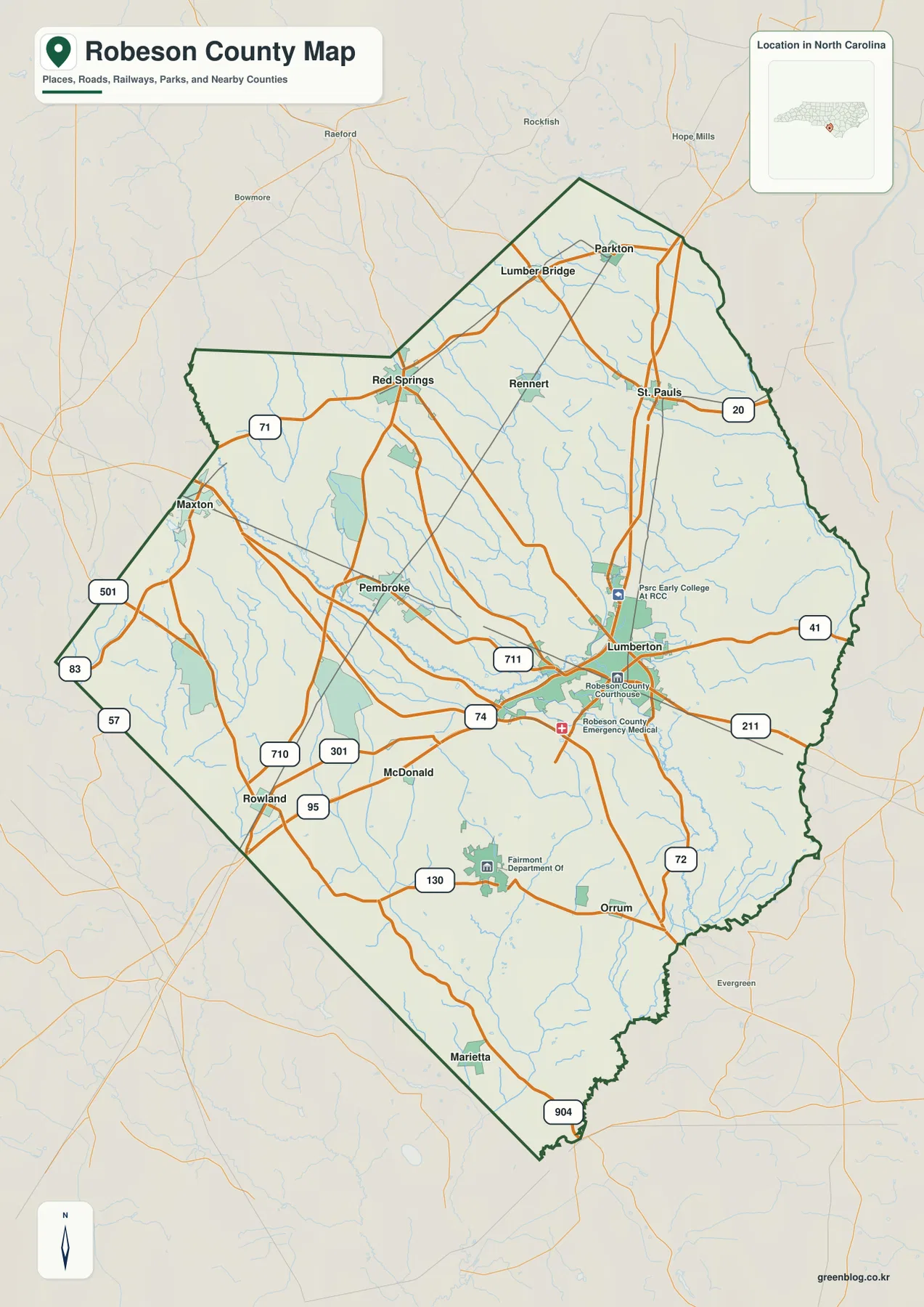
Red Springs is the clearest northwestern town reference. Roads branch east toward Pembroke and Lumberton and west toward the county edge, while Lumber Bridge and Parkton provide separate northern labels. This upper part of Robeson County has a very different settlement pattern from the Lumberton core, which is why Red Springs is useful even though it is much smaller than the county seat.
St. Pauls anchors the northeast, with route 20 extending eastward. Routes 41, 211, and 72 help define the eastern and southeastern portions, while Fairmont and Orrum sit farther south near route 130. Marietta and route 904 mark the lower end of the map. Seen together, these roads show a county with several town-centered areas rather than a single urban network.
The city map shows one large center and five smaller communities spread in different directions
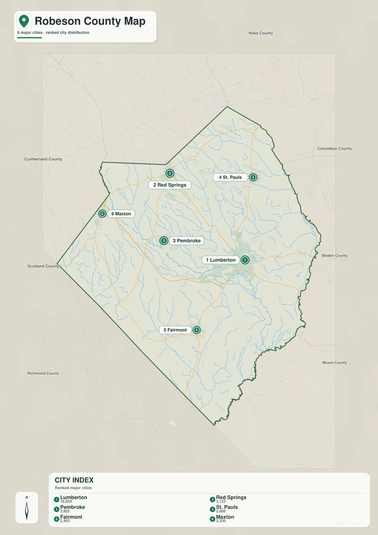
The supplied City Index ranks six communities. Lumberton is first with 18,859, Red Springs second with 3,125, Pembroke third with 2,822, St. Pauls fourth with 2,688, Fairmont fifth with 2,463, and Maxton sixth with 2,330. These are the values printed on this specific map image; this article does not reinterpret them as independently updated population estimates.
The geographic arrangement is more important than the ranking alone. Lumberton sits east of the county’s middle, Pembroke lies to the west, Red Springs farther northwest, St. Pauls to the northeast, Fairmont in the south, and Maxton near the western boundary. The six places are clearly not one continuous urban cluster. Each helps orient a different part of a very large county.
Pembroke deserves special attention because the existing county material identifies it as a university and Lumbee cultural center. That role is different from Lumberton’s county-seat and transportation function. Keeping the two places separate avoids turning every part of the county into a variation of Lumberton and better matches the way the supplied map places the communities.
Red Springs and Maxton help cover the west and northwest, while Fairmont provides a southern reference and St. Pauls a northeastern one. The city map does not show driving distance or route mileage, so actual travel should be checked against the general road map. Its strength is the uncluttered view of how the six major mapped communities divide the county.
Lumber River and the swamp network reveal the lowland geography behind the road map
The terrain-and-water map gives the county a very different visual structure. Lumber River is the strongest named water feature, running from the western-central area toward the southeast and passing through the Lumberton side of the county. On the general map, roads and city labels dominate the center. On the water map, the river becomes a long natural reference connecting several parts of Robeson County.
Horse Head Creek is labeled on the west, Ashpole Swamp farther southwest, and Mill Swamp in the north-central interior. Big Swamp follows the eastern side, while Branch of Lumber River appears in the southeast. These names show that the county is not drained by one river channel alone. A large network of slow lowland waterways and swampy corridors occupies the spaces between towns and roads.
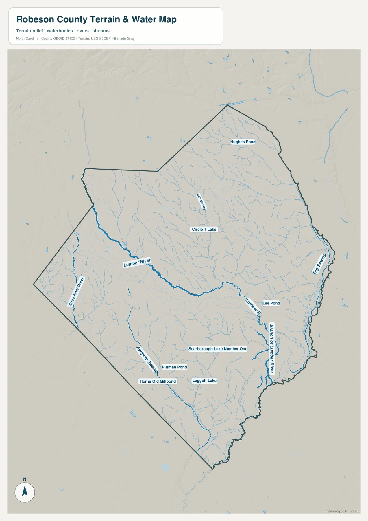
The map also labels Hughes Pond, Circle T Lake, Lee Pond, Scarborough Lake Number One, Pittman Pond, Horns Old Millpond, and Leggett Lake. None of these dominates the county at this scale, but together they provide useful small water references across the north, center, and south. Around Fairmont and the southern interior, those pond and lake names add geographic detail that is easy to miss on the road map.
The terrain shading is gentle rather than mountainous. The current county material describes Robeson as lying in the southern Coastal Plain near a Sandhills transition, and the water map is consistent with a low landscape where rivers, swamps, and shallow drainage are more important than sharp elevation changes. This is a general geographic reference, not a flood-hazard map, wetland-jurisdiction product, navigation chart, or parcel survey. Technical decisions require the official data linked below.
Lumberton, Pembroke, Red Springs, and Fairmont describe different parts of the same large county
Robeson County is too large for the role of one town to be projected across the entire map. Lumberton works best for county administration and major highways. Pembroke is more useful for the western university and Lumbee cultural area identified in the existing source material. Red Springs gives the northwest a separate small-town reference, while Fairmont helps orient the southern part of the county.
The general map makes Lumberton and Pembroke look connected by a relatively direct road network, but the city map still separates them as distinct centers. Red Springs lies farther north, Maxton near the western edge, and Fairmont well to the south. Keeping those directions separate gives the county a more realistic structure than a simple central-city model.
Lumber River provides a natural layer across those settlement areas. It runs through the central part of the county and continues southeast, while Horse Head Creek, Ashpole Swamp, Mill Swamp, and Big Swamp occupy other sections. The combination of road and water maps shows that the open spaces between the towns are not blank; they are crossed by lowland streams, swamps, local roads, and small water bodies.
The existing package also describes Robeson County as one of the larger counties in North Carolina and notes the cultural and educational importance of the Lumbee community. This article uses that source detail only where it helps explain the map. Pembroke should not be given the same administrative role as Lumberton, but it should not disappear simply because it is smaller. The two places are useful for different kinds of orientation.
Use the general map for roads and towns, and the water map for river and swamp geography
The general county map is the strongest choice when you need Lumberton, Pembroke, Red Springs, St. Pauls, Fairmont, Maxton, and the numbered road network in one view. I-95, US 74, US 301, US 501, and routes 711, 41, 211, 72, 130, and 904 provide useful anchors for moving through the large county.
The city-distribution map is cleaner when the goal is simply to compare the six ranked communities. It makes Lumberton’s size obvious while also showing that Pembroke, Red Springs, St. Pauls, Fairmont, and Maxton occupy very different parts of the county. Because road lines are reduced, this view should be used for settlement distribution rather than route planning.
The terrain-and-water map is the better reference for Lumber River, Big Swamp, Horse Head Creek, Ashpole Swamp, Mill Swamp, Branch of Lumber River, and the named ponds and lakes. It makes the broad lowland between towns visible and explains why a road-only view does not fully describe Robeson County’s physical geography.
The download ZIP contains three high-resolution A3 JPG files corresponding to the general county map, city-distribution map, and terrain-and-water map shown on this page. These files are larger than the WebP previews and are intended for printing, enlarged viewing, and document use. They are general geographic reference maps, so legal boundary decisions, surveying, flood determinations, wetland jurisdiction, and navigation should rely on the appropriate official technical data.
Frequently Asked Questions
Why should Lumberton and Pembroke remain separate map references?
Lumberton is the county seat and a major transportation reference, while Pembroke is identified in the supplied county material as a western university and Lumbee cultural center. They are relatively close, but they serve different geographic roles and should not be merged into one center.
What waterways are shown besides the Lumber River?
The water map labels Big Swamp, Horse Head Creek, Ashpole Swamp, Mill Swamp, and Branch of Lumber River. It also shows Hughes Pond, Circle T Lake, Lee Pond, Scarborough Lake Number One, Pittman Pond, Horns Old Millpond, and Leggett Lake.
What files are included in the Robeson County download ZIP?
The archive contains three high-resolution A3 JPG files corresponding to the general county map, the six-city distribution map, and the terrain-and-water map showing the Lumber River, swamps, creeks, ponds, and relief.
Map File Information
The ZIP contains three high-resolution A3 JPG files matching the Robeson County general map, city-distribution map, and terrain-and-water map shown on this page.
- Included Files: 3 high-resolution A3 JPG maps described on this page
- File Type: JPG files in a ZIP archive
- Intended Use: Printing, education, presentations, and map-based projects
Related Maps
Sources and References
- NCpedia – Robeson County
- U.S. Census Bureau – TIGER/Line Shapefiles
- USGS – National Hydrography
- USGS – 3D Elevation Program
These references provide county background, boundary and road data, hydrographic context, and elevation source information. The maps on this page are designed as general-purpose geographic references and downloadable map resources, so readers who need current legal boundaries or detailed technical water and elevation data should also consult the original agency sources.
Green Map creates custom-edited map images using open geographic data sources such as geoBoundaries, Natural Earth, OpenStreetMap, and government open data. These maps are edited visual materials, not raw data files, and are provided for education, documents, presentations, and graphic reference.