Bosque County lies in north-central Texas, where small towns are spread across a broad rural county rather than concentrated in one urban center. The maps on this page show the county from four practical angles: roads and boundaries, the relative position of major towns, rivers and creeks, and elevation. After reviewing the web maps, you can download matching high-resolution A3 JPG files in one ZIP for printing, classroom use, trip planning, or local reference work.
Meridian is the easiest place to use as an orientation point because it sits near the middle of the county and several numbered roads meet around it. Clifton is farther south and stands out as the largest community on the ranked city map. Walnut Springs, Morgan, and Kopperl sit to the north and northeast, while Cranfills Gap and Iredell mark the western side. Valley Mills is near the southeastern edge, and Laguna Park gives a useful reference for the Lake Whitney side of the county.
Table of Contents
Meridian Makes the Road Network Easy to Follow
The general county map is the best place to start when you need a quick sense of direction. Meridian appears near the center and works as a hub for several routes. Highway 6 runs south toward Clifton and Valley Mills, Highway 22 heads west toward Cranfills Gap, and Highways 144 and 174 connect the central part of the county with places farther north. Highway 56 extends east toward Laguna Park. Looking at those routes together makes it much easier to understand how the named communities are arranged.
The map also makes clear that Bosque County is not a simple rectangular county. Its eastern and northeastern edges bend around a series of irregular boundary sections, while the west has a broader diagonal edge. Nearby county names appear outside the border, including Hamilton, Somervell, Johnson, Hill, McLennan, and Coryell. Those labels are useful when the goal is to connect a Bosque County trip or study area with the larger part of central Texas.
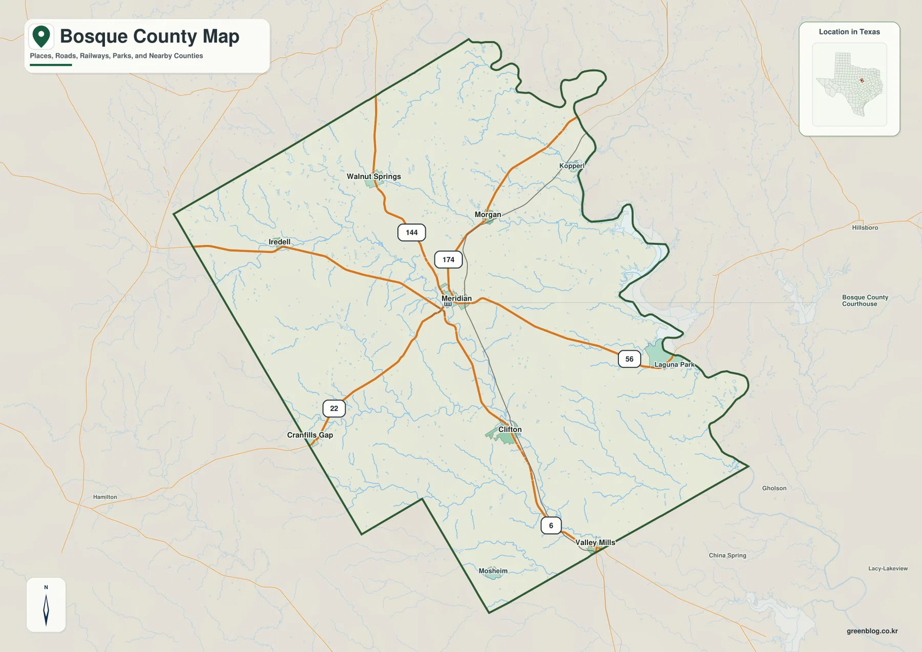
Some smaller places that matter for orientation are easier to find on this map than on the city ranking map. Iredell is west of Meridian, Kopperl is near the northeastern side, and Laguna Park sits near the eastern water edge. Mosheim also appears near the southern boundary. If a place is missing from the ranked city map, the general map should be the next reference because it includes a wider set of labels.
Clifton and Meridian Anchor the Ranked City Map
The city map compares six communities and places them in a simple rank order. Clifton is shown first with about 3,503 residents, followed by Meridian at about 1,638. Valley Mills is listed with about 1,136 residents, while Walnut Springs, Morgan, and Cranfills Gap are smaller. The main value of this map is not the ranking by itself; it is seeing how the larger and smaller communities are separated across the county.
Clifton sits in the southern half of the county close to the North Bosque River corridor. Meridian is farther north and more central, which is why it works better as the road and administrative reference. Walnut Springs and Morgan are well north of those two towns, while Cranfills Gap is near the western edge and Valley Mills is near the southeast. The distribution makes it clear that local travel often involves substantial distance between communities even when all of them are within the same county.
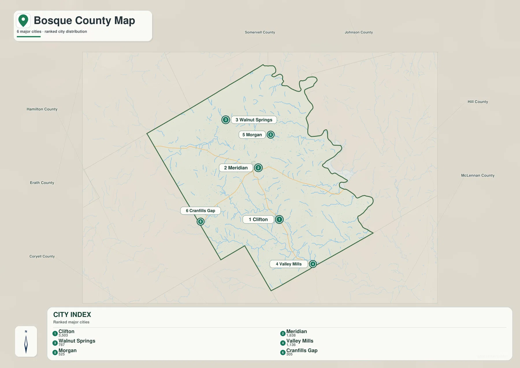
This ranked display is intentionally selective. Kopperl, Iredell, and Laguna Park appear on the general map but are not part of the six-city ranking shown here. That difference is useful to remember when using the maps for a specific address or local trip: the city map is a comparison tool, while the general map provides a broader set of place labels.
The North Bosque River Links a Dense Network of Creeks
Water is one of the strongest visual features of the county. On the terrain and water map, the North Bosque River runs through the central part of Bosque County and receives many smaller tributaries. The East Bosque River is labeled in the northwestern part of the county, and named creeks such as Spring Creek, Meridian Creek, Cedron Creek, Rocky Creek, and Childress Creek extend through different parts of the drainage network.
Several small lakes are also labeled. Mustang Lake, Irrigation Lake, and S Flat Top Lake are grouped in the northwest, Reed Lake appears farther south, and Santa Fe Lake is marked closer to the central-southern part of the county. These labels are helpful for locating water features and understanding where streams converge, but the map does not indicate public access, current water level, boating routes, or flood risk. Those questions require separate official sources.
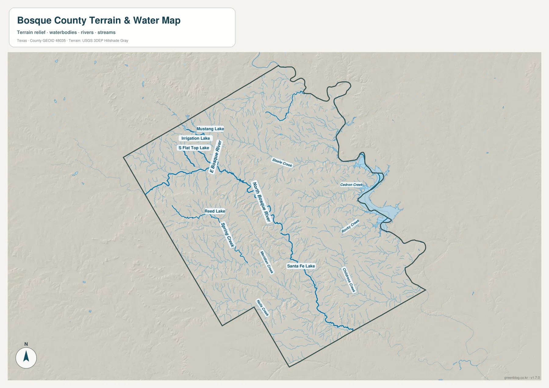
The eastern side of the county is shaped by larger water near the Lake Whitney area. Laguna Park is a convenient place name to use when switching between the general map and the water map, because it sits close to the irregular eastern boundary and reservoir-side landscape. From there, the county border follows a more complex line than it does along much of the west. The water map helps explain why that side of Bosque County looks so different from the straighter western boundary.
Higher Western Hills Give Way to Lower Ground in the East
The elevation map adds a clear west-to-east contrast. Brown and tan shades dominate many of the western and northwestern ridges, while greener colors spread across much of the east and southeast. The legend reports an actual mapped range of roughly 124 to 395 meters, with a mean elevation of about 254 meters. That range is broad enough to make the western uplands stand out immediately even without tracing individual contour lines.
Cranfills Gap is a useful western reference because the surrounding terrain is visibly higher and more broken than the lower country toward Clifton, Valley Mills, and the eastern water edge. Drainage valleys cut into the uplands, and many of the small creeks shown on the water map follow those lower channels. When the water and elevation maps are compared, the relationship between ridges, valleys, and the North Bosque River becomes much easier to see.
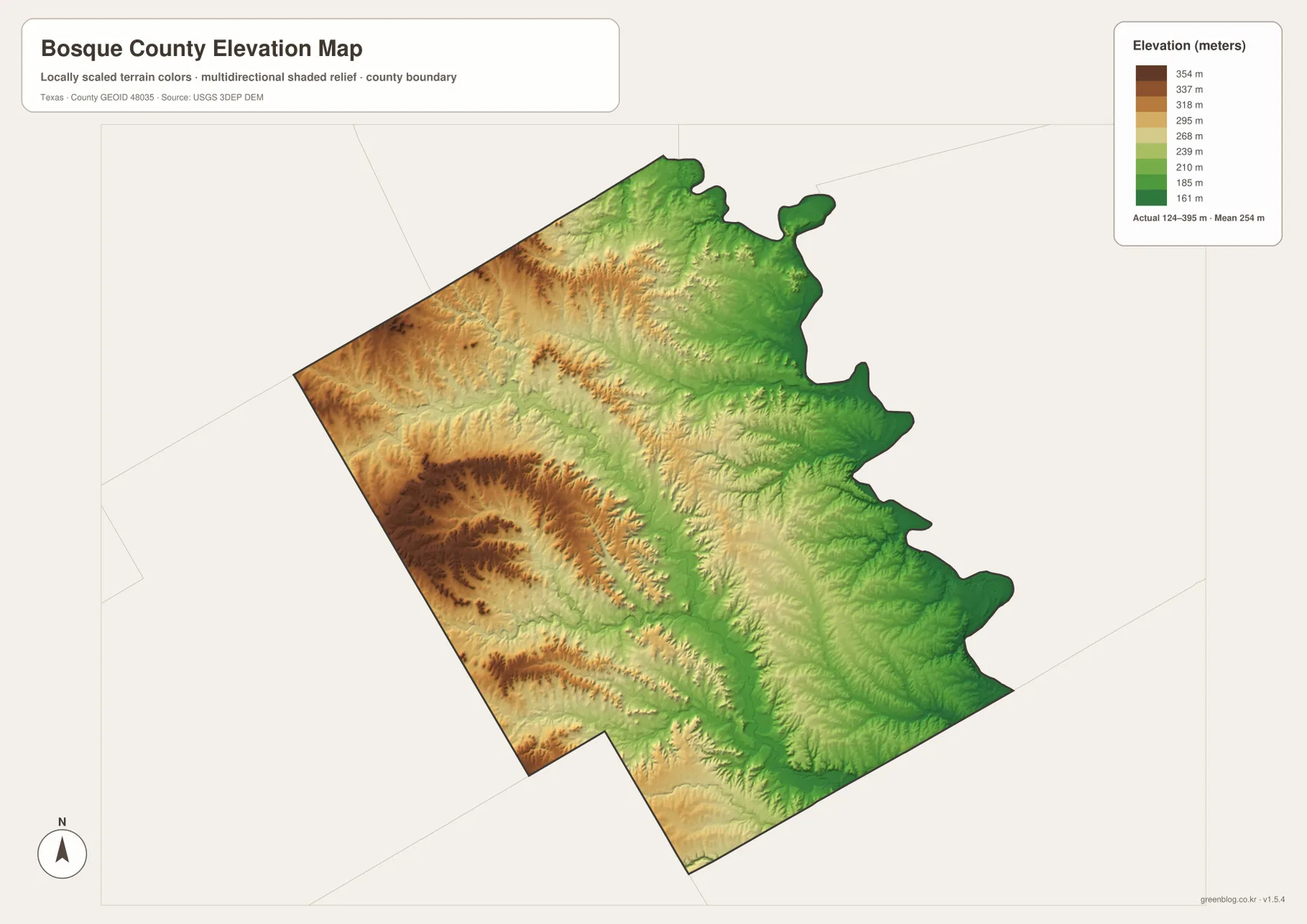
The elevation image is best used for regional comparison rather than site-level measurement. It shows where the county rises and falls, but it is not a survey map for a building lot, road project, or engineering decision. For exact elevations, the USGS 3D Elevation Program and field survey data are more appropriate sources.
Comparing the Same Place Across the Maps Reveals More
Meridian is a good example of why the maps work best as a set. On the general map, it is the central road reference where several routes meet. On the city map, it ranks second among the six displayed communities. The water map shows a dense collection of nearby creeks and the North Bosque River corridor, while the elevation map places Meridian between the higher western country and lower ground to the east. None of those facts is difficult on its own, but together they give the town a much clearer geographic setting.
Clifton provides a different comparison. It is the largest community on the city map, lies south of Meridian along Highway 6, and sits close to the North Bosque River. Its surroundings are lower than the more rugged western hills near Cranfills Gap. Valley Mills continues the Highway 6 line toward the southeast, where the terrain remains lower than much of the west. Those relationships are easier to remember when road, water, and elevation references are checked one after another.
The same method works on the Lake Whitney side. Start with Laguna Park on the general map, notice the irregular eastern boundary, then move to the water map to see the larger reservoir-side water and nearby tributaries. Finally, compare that area with the elevation map, where the eastern side appears lower than the western uplands. This simple sequence is useful for trip planning, school projects, or anyone trying to understand why different parts of Bosque County look and function differently.
Choose the Map That Matches the Task
For road orientation and place names, the general county map is the most practical starting point. The city map is better when the goal is to compare Clifton, Meridian, Valley Mills, Walnut Springs, Morgan, and Cranfills Gap. Use the water map for rivers, creeks, and small lakes, and use the elevation map when you need to explain the difference between the western hills and the lower eastern side. A class presentation or local study can often use two or more maps together instead of trying to force every detail into one image.
If you plan to print the maps, use the downloadable files rather than enlarging the web previews. The ZIP contains high-resolution A3 JPG versions of the county, city, water, and elevation maps shown on this page. Larger originals make road labels, town names, drainage features, and terrain differences easier to read on paper and are also convenient for keeping a local offline copy.
Frequently Asked Questions
Should I use Meridian or Clifton as my first map reference?
Use Meridian first when you need to understand roads and the overall county layout, because it sits near the center and several numbered routes connect through the area. Use Clifton as the second reference when comparing communities. Clifton is the largest city on the ranked map and lies south of Meridian along Highway 6, so finding both towns quickly establishes the central and southern parts of the county.
How do I connect the Bosque River system with the Lake Whitney side?
Start with the North Bosque River on the water map, then switch to the general map and find Laguna Park near the eastern edge. The reservoir-side water near that area belongs to the Lake Whitney setting, while tributaries such as Cedron Creek and Rocky Creek approach the eastern side from within the county. The map is useful for location and drainage context, but not for flood zones, water depth, or navigation.
What stands out most on the elevation map?
The strongest feature is the higher western and northwestern terrain, especially around the ridges near the Cranfills Gap side, compared with the lower east and southeast. The map legend reports an overall range of about 124 to 395 meters. For exact point elevations, however, use official elevation data or a survey rather than estimating from the regional color map.
Sources and Reference Data
These official sources provide additional county, hydrography, elevation, and Lake Whitney information.
- Official Bosque County website
- USGS The National Map Viewer
- USGS National Hydrography
- USGS 3D Elevation Program
- Texas Parks & Wildlife Department: Lake Whitney State Park
Map File Information
The ZIP contains high-resolution A3 JPG versions of the Bosque County boundary and road map, city map, water map, and elevation map shown on this page.
- File Type: JPG
Related Maps
- Somervell County
- Navarro County Texas map
- Parker County Texas map
- Tarrant County Texas map
- Williamson County Texas map
Green Map creates custom-edited map images using open geographic data sources such as geoBoundaries, Natural Earth, OpenStreetMap, and government open data.
These maps are edited visual materials, not raw data files, and are provided for education, documents, presentations, and graphic reference.