Daviess County sits in southwestern Indiana, where a winding western river edge contrasts with a straighter eastern county line and a noticeably rougher band of hills. Washington is the largest mapped community and the main road hub in the southwest. Odon and Elnora sit well to the north, Montgomery lies east of Washington, and smaller places fill the space between them. The four maps on this page show those settlements, major roads, waterways, lakes, and elevation in different levels of detail. High-resolution JPG versions of the same maps are also available in the ZIP download near the end of the article.
The quickest way to understand the county is to find Washington and then look west toward the White River. Washington is not centered geometrically, yet several important highways converge there, so it works as a practical reference point for the rest of the map. The western boundary is strongly curved where the White River runs along the edge of the county, and the land beside it is broad and low. Move eastward and the elevation colors become more varied, especially near the northeastern and southeastern edges, where creek valleys cut into higher ridges.
The elevation map gives an actual county-wide range of about 107 to 223 meters, with a mean near 152 meters. That range is modest compared with mountainous counties, but the distribution matters. Low green terrain spreads along the western river corridor, while yellow and brown ridges become much more common in the east. Around Dogwood Lake in the southeast, narrow valleys and higher ground sit close together. These changes help explain why the road network is not a uniform grid even though much of the western half appears relatively open.
Table of Contents
Washington forms the road hub while Odon and Elnora anchor the north
On the general county map, Washington is the strongest visual anchor. US 50 crosses the city from west to east and continues toward Montgomery, while State Road 57 runs north toward Plainville. State Roads 69 and 257 extend into the long southern part of the county. This arrangement makes Washington useful for orientation even though it lies closer to the southwestern side than to the geographic center. Once Washington is located, the White River is to the west, Montgomery is to the east, and the main northern communities can be placed above it.
The northern road pattern is more dispersed. Elnora sits close to the north county line, with State Road 425 running south toward the Plainville area. Odon lies farther east, near east-west routes and the roads that approach US 231, State Road 45, and State Road 58 on the eastern side. The map therefore does not show one single corridor controlling the entire county. Washington dominates the southwest, but Odon and Elnora provide separate reference points for the north, which is useful when locating addresses, neighboring communities, or routes that do not pass through Washington.
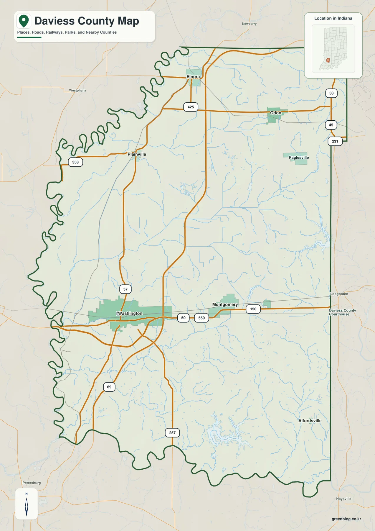
The outline also changes noticeably from one side to another. The west is irregular because the county edge follows the broad bends of the White River, while long parts of the east are comparatively straight. Outside the county, Knox and Pike counties lie to the west, Dubois County is toward the southwest, Greene County is north, and Martin and Sullivan counties appear on the eastern side of the map. Those neighboring labels are useful because they turn the border from a simple line into a directional reference for local travel and regional context.
East of Washington, Montgomery sits along the US 50 corridor, with Cannelburg farther east and Raglesville visible north of that line. Alfordsville appears in the southeastern part of the county. These smaller places matter because the eastern half would otherwise look empty between Odon and Washington. The general map is not a turn-by-turn navigation product, but it is very good at showing which communities share the same part of the county and which roads provide the broad connections among them.
Six mapped communities show a clear north–south split in settlement
The city-distribution map removes most road detail and ranks six communities: Washington first, Odon second, Montgomery third, Elnora fourth, Plainville fifth, and Cannelburg sixth. The ranking is useful, but the geography is more revealing. Washington and Montgomery form the main southern pair, while Odon and Elnora sit much farther north. Plainville occupies a more northwestern position between those groups, and Cannelburg extends the settlement pattern east of Montgomery. The result is a county with several separated community centers rather than one continuous urban strip.
This simplified view is especially helpful before reading the more detailed road map. A visitor can remember Washington in the southwest, Odon in the northeast, and Elnora in the northwest, then place Montgomery, Plainville, and Cannelburg around those anchors. When you return to the general map, the numbered highways make more sense because the destination points are already familiar. The city map does not imply travel time or direct road distance; it is a location diagram designed to make the county’s settlement pattern easy to compare.
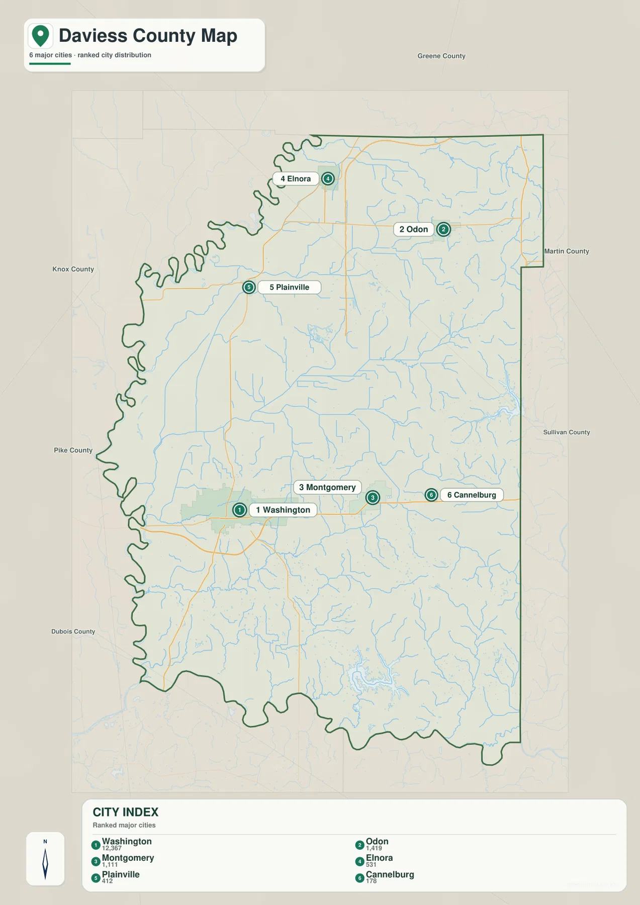
Neighboring county labels add another layer of orientation. Greene County is north, Martin County is east, Sullivan County is southeast, Dubois County is southwest, and Pike and Knox counties lie to the west. These labels make it easier to understand why some communities sit close to a county edge and may connect naturally with places outside Daviess County. For actual driving, use the general map or a current navigation service. For learning the county’s internal layout, the city-distribution map is the cleaner choice.
White River lowlands meet Prairie Creek valleys and southeastern lakes
The terrain-and-water map makes the western edge immediately recognizable. The White River follows the county boundary through a series of broad bends, and the adjacent terrain is low and relatively smooth. Farther east, named creeks form a denser network. Smothers Creek crosses the northern interior, North Fork Prairie Creek runs across the central part of the county, and South Fork Prairie Creek continues through the south-central area. Instead of one dominant drainage line, the eastern half contains many smaller valleys that feed toward the larger river system.
Several additional streams help define the southern landscape. Flat Creek appears in the east, while Veale Creek and Alkman Creek cross the southern interior. Mud Creek is labeled near Dogwood Lake in the southeast. The shaded relief beneath the blue water lines is important because it shows that these creeks occupy lower corridors between ridges. When the same locations are checked on the elevation map, the creek valleys remain green while nearby ground rises quickly into yellow and brown terrain.
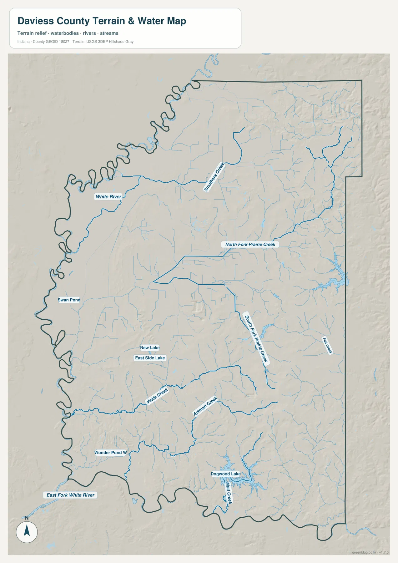
The map also labels several standing-water features. Swan Pond lies near the west, New Lake and East Side Lake appear near Washington, Wonder Pond W is in the southwest, and Dogwood Lake is the most prominent lake in the southeast. These labels are useful reference points when comparing the water and elevation maps. They should not be treated as statements about water depth, access, boating rules, or shoreline ownership. For recreation or property questions, the responsible agency’s current information is more appropriate than this county-scale reference map.
This water layer is also not a flood map, parcel map, or navigation chart. The broad lowlands along the White River may suggest where major river terrain lies, but they do not establish whether a specific property is in a regulated flood zone. Flood insurance, construction, drainage, and legal-boundary decisions require current official datasets and site-specific information. Here, the map is best used to understand how the western river edge differs from the branching creek valleys across the center and east.
Elevation rises from the western river edge into the east and southeast
The elevation map shows Daviess County from about 107 to 223 meters, with an average near 152 meters. The lowest greens spread along the western White River edge and across much of the adjacent lowland. That broad low area is one of the most distinctive features on the map. Moving east, the colors shift through lighter green and yellow, and brown ridge tops become more common near the northeastern and eastern borders. The county is not simply tilted from west to east, but higher and more broken terrain clearly becomes more frequent away from the river.
The eastern half is dissected by many narrow valleys. Northeast of Odon, long ridges sit close together, separated by tributary channels. In the southeast, the Dogwood Lake and Mud Creek area has the same pattern on a smaller scale: low water corridors cut through higher ground. This combination explains why the water map contains so many branching streams. The high ground is divided into separate ridges, and the creeks occupy the lower passages between them.
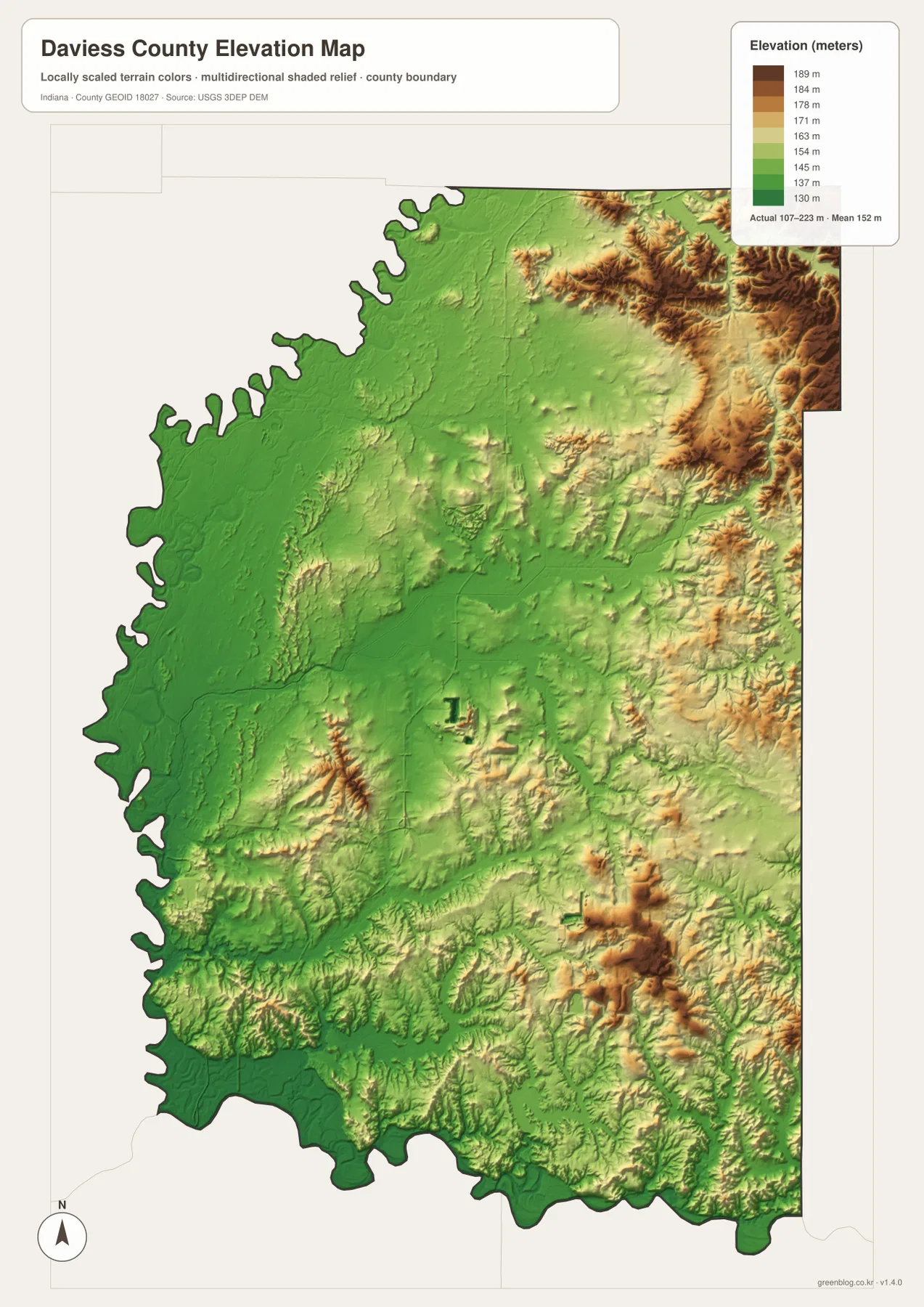
Washington occupies a transition rather than an extreme. The city is surrounded by comparatively gentle terrain, but the ground becomes more varied to the east and southeast. North toward Plainville and Elnora, broader low-relief areas reappear before the rougher northeastern edge. Comparing the elevation map with the road map helps explain why some routes can run for long straight stretches in the flatter west while others bend more frequently near the hillier margins.
The elevation colors are generalized for county-scale comparison. Actual ground height varies within each color band, and small road cuts, embankments, building pads, and drainage features may not appear accurately at this scale. Surveying, engineering, construction, and detailed drainage work require the underlying USGS elevation data or a professional survey. For this article, the useful takeaway is the broad contrast between the White River lowlands and the more dissected eastern terrain.
Use the maps together for roads, waterways, or terrain
For basic orientation, begin with the general county map and locate Washington, Odon, and Elnora. US 50 provides a clear east-west reference through Washington and Montgomery, while State Road 57 points north toward Plainville. Switch to the city-distribution map when you want to remove road detail and compare where the six ranked communities sit within the county. This two-step approach is useful because it separates the question of “where is the community?” from “which road reaches it?”
For landscape questions, begin at the White River on the terrain-and-water map, then follow Smothers Creek and the two Prairie Creek forks eastward. After that, open the elevation map and look at the same corridors. The relationship becomes immediate: broad green lowlands dominate the west, narrow green creek valleys extend into the interior, and higher yellow or brown ridges fill the spaces between them. Dogwood Lake and Mud Creek make particularly useful checkpoints in the southeast because both maps show the same valley-and-ridge setting there.
The WebP images embedded in the article are reduced for faster loading. If you need to enlarge small road labels, read creek names, print the maps, or keep offline copies, use the original high-resolution JPG files in the ZIP below. Each JPG is 2572 × 3638 pixels. The archive contains the general county map, city-distribution map, terrain-and-water map, and elevation map. These are reference maps rather than legal parcel, flood-determination, engineering, or survey products.
Local sources add context to Washington and Dogwood Lake
Daviess County’s official government website lists both the courthouse and county government center in Washington. That matches the general map, where Washington is the largest built-up area and the most obvious road hub. The Daviess County Visitors Bureau also emphasizes lakes, rivers, parks, and outdoor recreation as part of the county’s local setting. Those sources add community context to the geographic patterns visible here, while the maps remain focused on county-wide location rather than visitor services or facility details.
Dogwood Lake, clearly labeled in the southeastern part of the water map, is also covered by Indiana DNR information for Glendale Fish & Wildlife Area. The DNR page provides current rules and access information for the property and lake. This county map does not show the precise property boundary, boat-launch details, or recreation closures, so those should be checked on the DNR’s own material. At county scale, the map is most useful for placing Dogwood Lake in relation to Mud Creek, the southeastern ridges, and the rest of Daviess County.
Frequently Asked Questions
Which map is best for comparing Washington, Odon, and Elnora?
Start with the city-distribution map because it removes most road detail and makes the north-south spacing easy to see. Washington is in the southwestern half, Odon is northeast of it, and Elnora sits farther northwest. When you need the actual highway pattern, switch to the general map and use US 50, State Road 57, State Road 425, and the eastern routes as reference lines.
Where is the strongest terrain contrast in Daviess County?
The clearest contrast is between the broad low White River side in the west and the higher, more dissected terrain toward the northeast, east, and southeast. The elevation map spans about 107 to 223 meters. Creek valleys cut through the higher eastern ground, so the transition is not one smooth slope but a repeated pattern of ridges and low channels.
What files are included in the Daviess County download?
The ZIP contains high-resolution JPG versions of the same four maps used in the article: the general county map, city-distribution map, terrain-and-water map, and elevation map. Each image is 2572 × 3638 pixels. They are suitable for closer viewing and printing, but they are reference products and should not replace parcel, flood, survey, or engineering maps.
Map File Information
Download the Daviess County maps as high-resolution JPG files for closer viewing, printing, or offline reference.
- File Type: JPG
Related Maps
Sources and references
- Daviess County official website — county government and Washington courthouse context
- Daviess County Visitors Bureau — local lakes, rivers, parks, and visitor information
- Indiana DNR — Glendale Fish & Wildlife Area and Dogwood Lake information
- U.S. Census Bureau TIGER/Line Shapefiles — county boundaries, roads, and places
- USGS National Hydrography — rivers, streams, and drainage data
- USGS 3D Elevation Program — elevation and terrain data
Green Map creates custom-edited map images using open geographic data sources such as geoBoundaries, Natural Earth, OpenStreetMap, and government open data.
These maps are edited visual materials, not raw data files, and are provided for education, documents, presentations, and graphic reference.