Lincoln County in south-central Idaho spreads across a broad plain where Shoshone, Richfield, and Dietrich are separated by long roads and a dense network of rivers, sloughs, and canals. The county map is the best place to begin because it combines the county outline, community names, and numbered roads. The terrain-and-water map shifts attention to the Big Wood River, Little Wood River, Coldwood Slough, and the many canals crossing the western and central parts of the county. The elevation map then shows a clear contrast between the broad lower plain and higher ground toward the northwest. This page explains only features visible in the supplied maps, and the same four maps are available as high-resolution JPG files in a downloadable ZIP archive.
The county outline is wide from west to east, with a stepped southern boundary and a deeper projection in the southeast. Shoshone sits in the western half, Richfield lies to the northeast, and Dietrich is southeast of Shoshone. The city map also labels Gooding County, Jerome County, Blaine County, Camas County, and Minidoka County around the outside, which makes the county’s position within the surrounding area easier to understand. Using those three communities as reference points makes the later water and elevation maps much easier to follow.
The WebP images in the article are convenient previews for online reading. The download archive contains the original JPG versions of the county map, city-connections map, terrain-and-water map, and elevation map, each at 3638×2572 pixels. Those larger files are useful when small road numbers or canal labels need to be enlarged. They are not parcel maps, flood maps, irrigation-right documents, live traffic maps, or survey-grade elevation products, so specialized decisions should be based on current agency data.
Table of Contents
Roads spread from Shoshone toward Richfield, Dietrich, and the county edges
Shoshone is the easiest visual anchor on the general county map because several roads meet or pass close to it. Richfield is shown to the northeast and Dietrich to the southeast. The map labels major numbered routes including 75, 93, 26, and 24, along with additional road numbers such as 620, 370, 550, 270, and 600. Following those lines from Shoshone makes it possible to see how travel directions divide across a county that is much wider than the cluster of named communities might suggest.
Tunupa is labeled to the west, while Shoshone is surrounded by a denser mix of roads and blue water lines. The route toward Richfield extends northeast across the central part of the county, and the map shows 26 and 93 near the northeastern side. Farther east and southeast, long roads cross areas with few community labels. The value of this map is therefore not simply the number of towns it names; it is the way roads, communities, and the county outline can be read together.
The stepped boundary is important when following a road near the southern side of the county. A line that appears to continue in one direction can move close to the county edge as the outline turns south and east. The general map is useful for broad orientation, but it should not be treated as a legal boundary survey or as a source for exact jurisdiction at a specific property. For ordinary map reading, it gives enough context to place Shoshone, Richfield, Dietrich, and the main numbered roads inside the county shape.
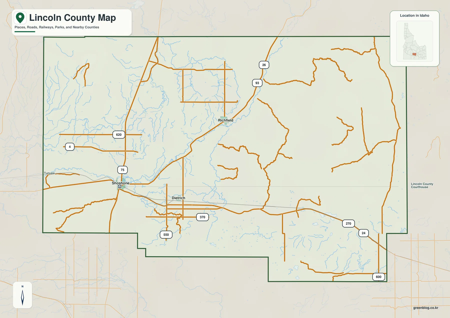
Richfield is 15 miles and Dietrich 7 miles from Shoshone by straight-line distance
The city-connections map simplifies Lincoln County to three highlighted communities and uses Shoshone as the hub. Richfield is labeled 15 miles from Shoshone, while Dietrich is labeled 7 miles away. These are direct, straight-line distances, not driving distances along the road network. Actual trips can be longer because roads bend, intersect, or follow a different route than the shortest line between two points.
The map also makes the directions easy to compare. Shoshone lies in the west, Richfield is northeast of it, and Dietrich is southeast. Because Richfield and Dietrich sit on different sides of the eastward direction, the three communities do not form a single straight corridor. That arrangement helps explain why the general county map shows roads branching rather than following one simple east-west route.
County labels around the map provide additional orientation. Blaine County and Camas County are shown to the north, Minidoka County to the east, and Gooding County and Jerome County to the west. The city map deliberately removes most of the road detail so that the relative positions of Shoshone, Richfield, and Dietrich remain clear. It works best as a quick location and distance reference, with the general county map used for the actual road context.
Big Wood River, Little Wood River, and canals form a dense water network across the plain
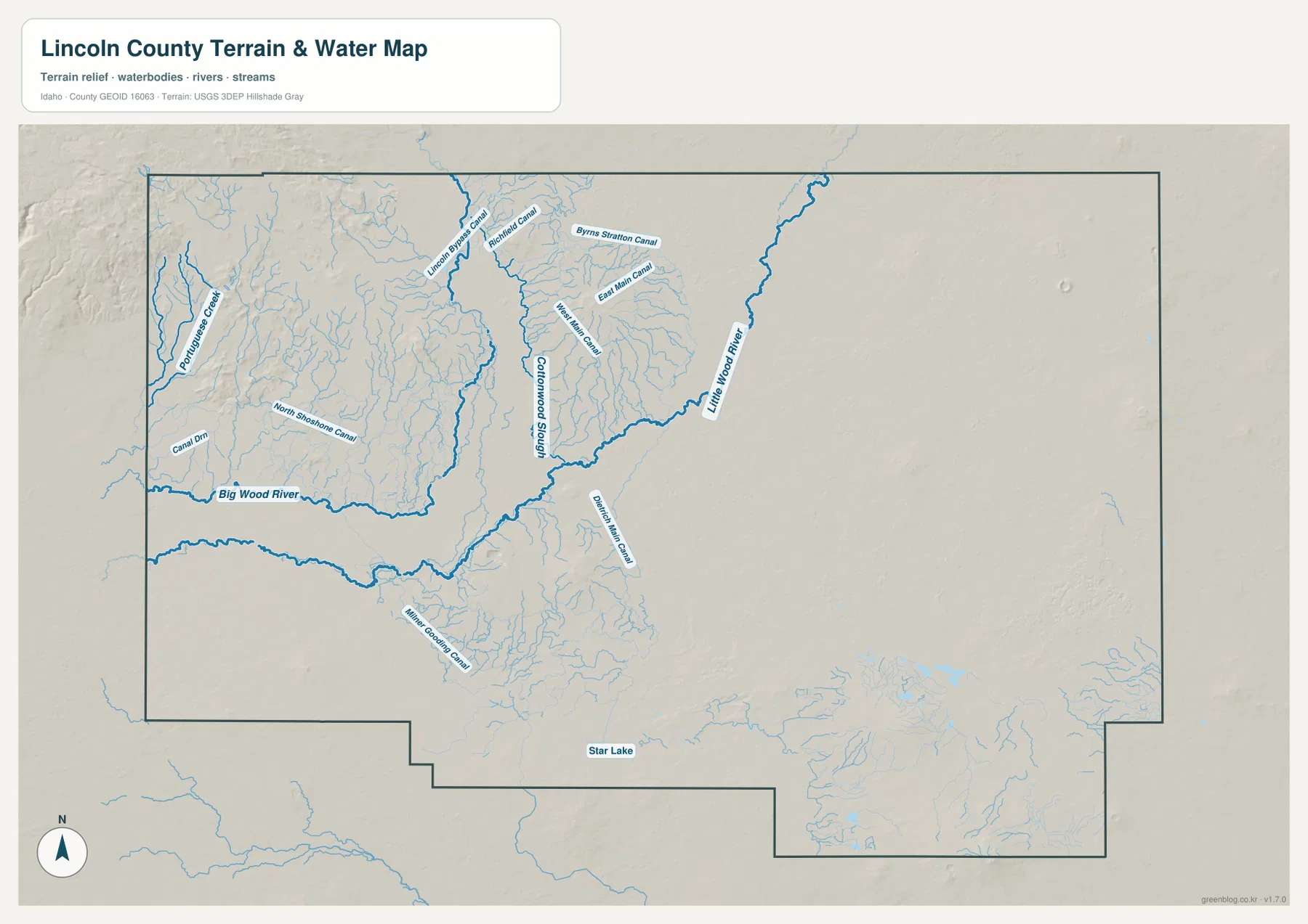
The terrain-and-water map changes the character of Lincoln County by revealing how many waterways cross the western and central plain. Big Wood River enters from the west and continues toward the middle of the county. Little Wood River descends from the northeast and joins the broader network of channels near the center. Between and around those rivers, numerous smaller blue lines show canals, sloughs, tributaries, and other mapped water features.
Several names are readable on the map, including Lincoln Bypass Canal, Richfield Canal, East Main Canal, North Shoshone Canal, Milner-Gooding Canal, and Coldwood Slough. Star Lake is labeled farther south. These labels help distinguish the natural rivers from the many named channels, but the map does not define ownership, irrigation rights, public access, or operating status. A canal shown here should be read as a mapped water feature rather than as permission to enter, divert, or use the water.
The western half of the county contains the densest concentration of blue lines, especially around the Shoshone area and north toward Richfield. The broad eastern area is much less crowded with named channels. Comparing this view with the elevation map adds useful context because many of the dense water features lie on the lower, flatter portions of the county. This is a reference map for the location of rivers, canals, sloughs, and lakes; it is not a flood-hazard map or a navigation product.
Elevation rises from the broad central plain to high ground in the northwest
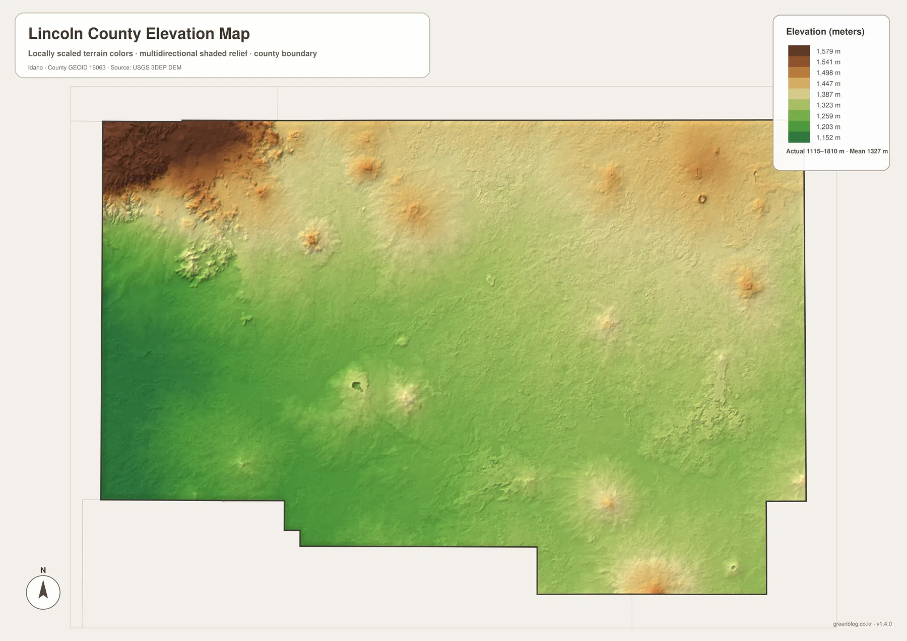
The elevation map reports an actual county range of about 1,115 to 1,810 meters, with a mean near 1,327 meters. Green dominates much of the central and southwestern area, indicating the lower part of the local range. The northwest corner changes through yellow into brown and is the most extensive high area on the map. Smaller isolated high spots also appear in the north, east, and southeast, but they do not cover as much area as the northwestern high ground.
Around the central plain, elevation changes are comparatively gradual and the colored surface remains broadly consistent. Moving northwest produces a much stronger color transition and more pronounced shaded relief. The eastern half contains scattered raised features against a smoother background, while the long southeastern extension includes a few locally higher areas near its lower edge. This view is useful for understanding the overall direction of elevation change without requiring every contour or spot height to be labeled.
The water map and elevation map are especially useful as a pair. Big Wood River and many of the canals occupy the lower western and central portions of the county, while the higher northwestern area has a different visual pattern and fewer dense canal labels. That comparison helps explain the broad relationship between terrain and mapped waterways without claiming that elevation alone determines the water network. The colored surface is generalized for county-scale comparison and should not replace precise USGS elevation data or professional surveying for a particular site.
Use the map that matches the detail you need
For basic orientation, the general county map is the most efficient starting point because it places Shoshone, Richfield, Dietrich, roads, and the county outline together. The city-connections map is better when the question is simply where the three highlighted communities sit relative to one another and how far Richfield and Dietrich are from Shoshone in straight-line terms. It removes most secondary information and makes the community pattern easier to see.
When a river or canal name is the target, the terrain-and-water map contains far more detail. It is the appropriate view for Big Wood River, Little Wood River, Coldwood Slough, Star Lake, and the named canal system. The elevation map answers a different question by showing how the broad plain compares with the higher northwest and smaller raised areas elsewhere. Switching between those two maps is often more informative than trying to interpret waterways and terrain from one image alone.
The high-resolution JPG files are useful for classroom handouts, printed reference sheets, presentations, or simply zooming in on small labels. The ZIP contains only the four maps described on this page, so it does not include parcel, land-cover, flood, satellite, or live road layers. Each map remains a separate JPG, allowing the reader to use only the view needed for a particular task.
Frequently Asked Questions
Are the 15 miles to Richfield and 7 miles to Dietrich driving distances?
No. The city-connections map states that its distances are direct distances from Shoshone. They are straight-line measurements, not mileages along the road network. Driving routes can be longer, so a current road map or navigation service should be used when planning an actual trip.
Which map shows Big Wood River, Little Wood River, and the canals?
The terrain-and-water map is the detailed water reference. It labels Big Wood River, Little Wood River, Coldwood Slough, several named canals, and Star Lake. It is intended to show the location of mapped water features and surrounding terrain, not flood zones, water rights, or legal access.
Can the 1,115–1,810 m elevation range be used for surveying?
No. That range summarizes county-scale terrain and is useful for comparing the lower plain with higher northwestern ground. Precise property, construction, or engineering work should use the underlying USGS elevation data and appropriate professional surveying rather than values read from this generalized map.
Map File Information
Download the Lincoln County county, city-connections, terrain-and-water, and elevation maps as high-resolution JPG files in one ZIP archive.
- Included Files: county map, city-connections map, terrain-and-water map, elevation map
- Printable Size: 3638×2572 pixels for each JPG
- File Type: ZIP containing 4 JPG files
Related Maps
Sources and reference links
Local government information is available from the official Lincoln County, Idaho website. Boundary and administrative geography can be checked with the U.S. Census Bureau TIGER/Line Shapefiles.
Water features are supported by USGS National Hydrography, and elevation reference data are available through the USGS 3D Elevation Program.
Green Map creates custom-edited map images using open geographic data sources such as geoBoundaries, Natural Earth, OpenStreetMap, and government open data.
These maps are edited visual materials, not raw data files, and are provided for education, documents, presentations, and graphic reference.