Campbell County in northeastern Tennessee is much easier to understand when its towns are viewed together with the ridges and valleys around them. You can download the county, city, water, and elevation maps on this page as a ZIP containing four high-resolution A3 JPG files. La Follette and Jacksboro sit close to one another in the south-central part of the county, Caryville lies just to the west beside I-75, and Jellico is separated far to the north. The eastern and southeastern side looks different again, with the broad Clinch and Powell river waters occupying lower ground.
The county does not have a simple grid of roads laid across a broad plain. Long ridges run through the interior, narrow valleys provide natural corridors, and streams often occupy the same lower passages that roads use. That terrain helps explain why I-75 follows a long north-south route from Caryville toward Jellico while the La Follette-Jacksboro area is connected differently by Route 63. The elevation and water maps are therefore more than decorative companions to the road map: they show the physical setting that makes the road pattern and settlement pattern easier to understand.
A good way to read the set is to begin with La Follette, Jacksboro, Caryville, and Jellico, then add I-75, Route 63, the Clinch and Powell rivers, and a few named creeks or lakes. Once those anchors are familiar, the smaller roads and tributaries become much easier to place. The maps are intended for county-scale orientation, printing, lessons, presentations, and general reference. They are not substitutes for current navigation, live flood information, engineering measurements, or legal parcel records, so those needs should be checked against the appropriate official source.
Table of Contents
La Follette, Jacksboro, and Caryville Give the Clearest Starting Point
The general county map places La Follette and Jacksboro near one another in the south-central portion of Campbell County. Caryville appears a short distance to the west, where the interstate becomes the most obvious north-south transportation line. Fincastle provides a useful reference east of La Follette, while Jellico is clearly detached from the main south-central cluster and sits near the northern edge. Seeing these locations together makes it clear that the county is organized around several valley corridors rather than one compact center with roads spreading evenly in every direction.
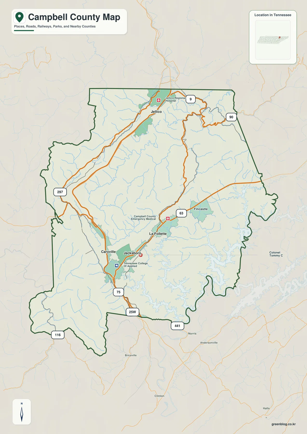
I-75 is the simplest line to follow first. It enters the county from the south near Caryville and continues through a long valley toward Jellico. Route 63 provides a different orientation around La Follette and Jacksboro, extending eastward from the south-central community area. Other numbered routes, including 25W, 441, 116, 297, 9, and 90, add local and regional connections. Instead of trying to memorize every number, readers can use I-75 and Route 63 as the primary framework and then see where the other routes branch toward nearby communities or mountain valleys.
The map also includes a few selected facilities that help confirm settlement locations. Jellico Regional Hospital is marked near Jellico, while Campbell County Emergency Medical and the Tennessee College of Applied Technology appear around the La Follette-Jacksboro area. These are useful landmarks, but the larger pattern matters more than the facility list. Towns and roads occupy lower corridors between ridges, and the irregular county outline means that routes continue across the boundary in several different directions rather than stopping at a neat rectangular edge.
For general orientation, this is the most versatile map in the set because it keeps communities, major roads, the county boundary, streams, and selected points in one view. It works well as the first page in a classroom handout or regional presentation because readers can establish where the main places are before moving to specialized details. When the question becomes more specific—such as how far Jellico is from La Follette, which creek passes near Caryville, or where the highest ridges appear—the city, water, and elevation maps provide a cleaner answer.
The City View Shows How Far Jellico Sits from the South-Central Towns
The simplified city map removes much of the background detail and emphasizes four places: La Follette, Jacksboro, Caryville, and Jellico. La Follette is identified as the hub city, and the printed reference distances show Jacksboro at about 4 miles, Caryville at about 6 miles, and Jellico at about 13 miles from that hub. These values are direct straight-line distances shown for comparison, not road mileage. In mountainous terrain, a short line on a map can translate into a longer drive because roads must follow valleys, passes, and available crossings.
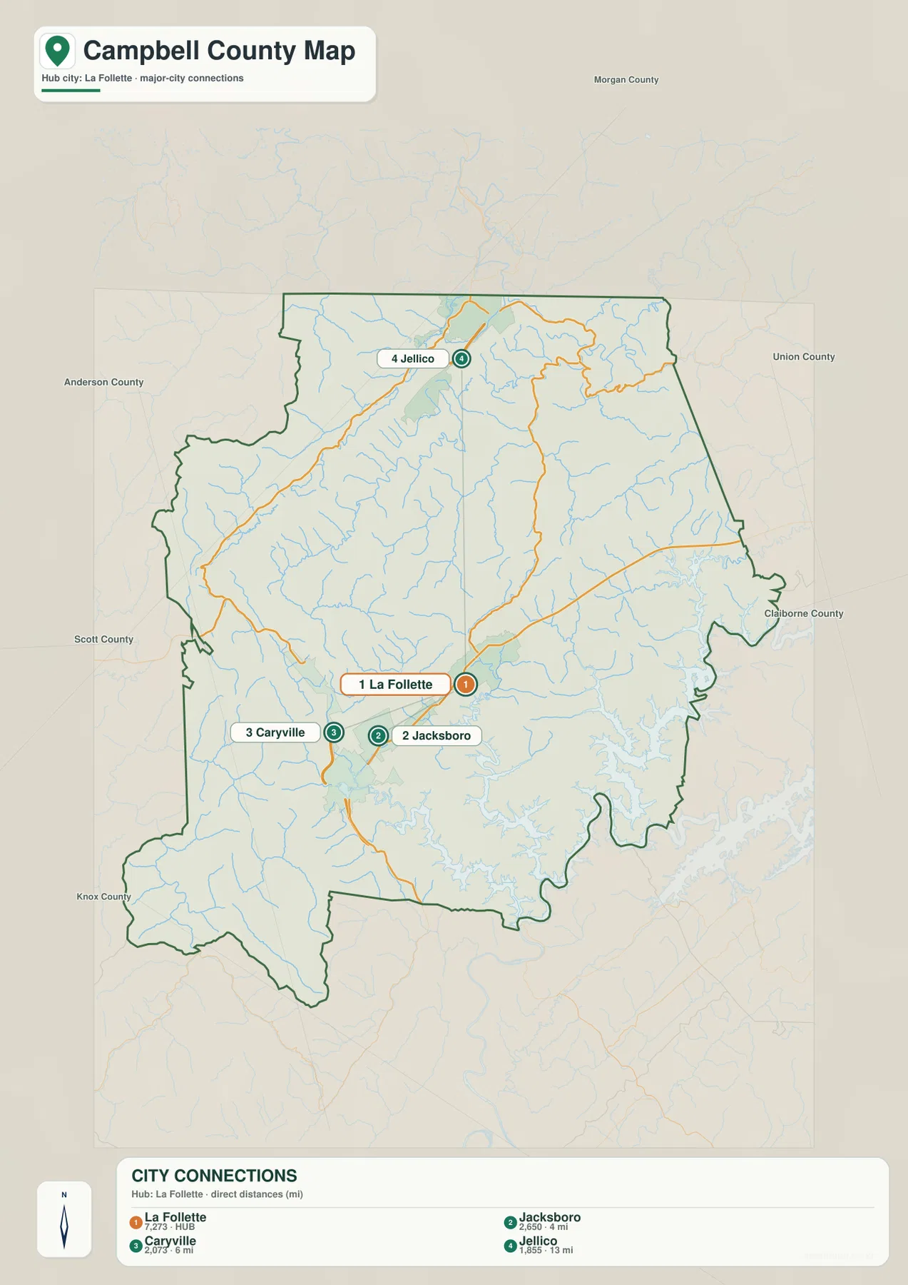
Jacksboro and Caryville are both close to La Follette, but they are useful reference points for different reasons. Jacksboro is the county seat, so it provides an administrative anchor for the south-central area. Caryville is the easier place to connect that cluster with I-75 and the route south out of the county. Jellico serves a different role entirely: it marks the northern end of the long interstate corridor and is visibly separated from the other three communities. That separation is one of the most important geographic relationships to understand before looking at the denser county map.
Names of neighboring counties appear around the outside of the city map, including Anderson, Scott, Morgan, Union, and Claiborne counties. They help place Campbell County in a wider regional setting and make the boundary easier to interpret. Roads and streams do not end when they reach that boundary, however, so the map should be treated as a county-scale orientation tool rather than a complete regional travel map. For precise addresses, driving times, construction closures, or turn-by-turn directions, a current transportation or navigation source is the better choice.
This city layer is particularly useful when a presentation needs a clean explanation without the visual weight of every road and tributary. A presenter can establish La Follette, Jacksboro, Caryville, and Jellico first, then return to the county map and add I-75 or Route 63. That sequence helps readers understand that the three south-central places form a close group while Jellico occupies a separate northern corridor. The more detailed physical geography becomes easier to follow once those basic town positions are fixed.
Clinch and Powell River Waters Occupy the Lower Southeastern Valleys
The water map changes the emphasis from communities to rivers, reservoirs, and mountain creeks. The broadest water is concentrated in the eastern and southeastern part of the county, where the Clinch River and Powell River systems spread through lower valleys. Closer to the south-central communities, Cove Lake and La Follette Reservoir provide smaller but very recognizable water references. Farther north and through the interior, numerous named creeks trace narrow valleys between ridges, revealing a drainage pattern that is difficult to appreciate on the general road map alone.
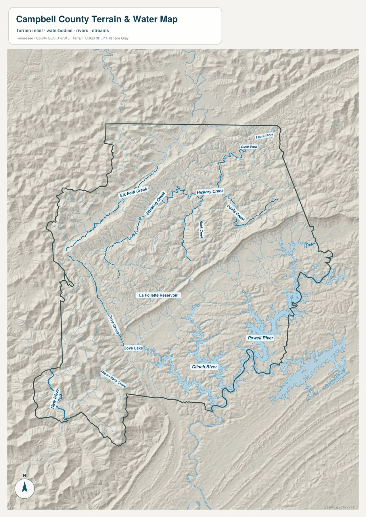
Several labels make the interior drainage easier to follow. Clear Fork and Laurel Fork appear in the northern and northeastern terrain, while Elk Fork Creek and Stinking Creek occupy long valleys farther west. Hickory Creek, Davis Creek, and Rock Creek run through the central ridges toward the larger southeastern water system. Cove Creek is especially useful for orientation near Caryville because it can be compared directly with Cove Lake and the nearby road corridor. Following each creek as part of a valley is more informative than reading the names as an isolated list.
The southwestern projection of the county adds another important detail. New River is labeled there, with Round Rock Creek nearby, showing that not every stream in Campbell County drains toward the same southeastern river arms. The ridges divide adjacent valleys into different drainage directions. Two creeks can begin relatively close to one another yet head toward different parts of the map because a high ridge separates their paths. This is one reason the water map works particularly well beside the elevation map: the stream network and the ridge pattern reinforce one another.
This layer is designed to show the location of rivers, streams, lakes, reservoirs, and the surrounding terrain. It does not depict live water levels, official flood zones, boat navigation conditions, dam operations, or private property boundaries. Those topics require current specialized data. For geographic education, regional comparison, or a printed reference showing how water occupies Campbell County’s valleys, the map is useful because it places named water features directly on shaded relief instead of presenting them as disconnected blue lines.
Elevation from About 252 to 1,076 Meters Reveals Repeating Ridges and Valleys
The elevation map states a local range of approximately 252 to 1,076 meters and a mean elevation near 483 meters. The colors show that this range is not produced by one isolated high point surrounded by flat land. Broad green lowlands occupy much of the southeastern river area, while higher yellow, tan, and brown ridges repeat across the center and western side. The southwestern projection contains especially strong high-relief terrain, and the northern Jellico area also alternates between elevated ridges and lower corridors rather than forming a broad flat basin.
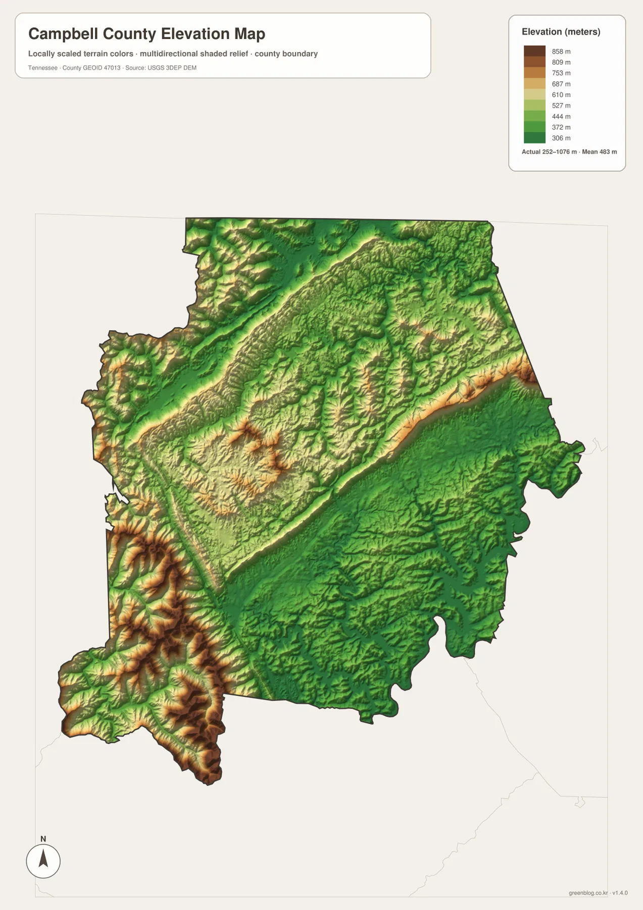
A long elevated band runs diagonally across the central portion of the county, with lower valleys on either side. The pattern repeats often enough that the surface looks folded into parallel ridges and troughs rather than gently rolling in one direction. This matters for map reading because transportation routes cannot simply cross every ridge on the shortest straight line. Major roads tend to use lower passages, and streams occupy many of the same valleys. When the elevation layer is compared with the county map, the curves and direction changes in the road network become much more understandable.
The southeastern section is noticeably lower and more open in the elevation coloring, matching the broad Clinch and Powell river waters seen on the water map. In contrast, darker and warmer colors mark higher terrain in the central, western, and southwestern parts of the county. That difference also helps explain why a place can appear close to another point on a county outline but still require a longer road connection. The practical path often follows a valley around high ground rather than crossing a ridge directly.
The elevation colors are intended for county-scale terrain comparison. They are not survey measurements for a building site, road design, slope-stability study, or property transaction. Exact elevations for engineering or legal work should come from more precise official data or field measurement. For ordinary map users, the main value is simpler: the layer clearly shows where the broad low river valleys are and where the high ridges dominate the landscape.
I-75 and Route 63 Make More Sense When the Valleys Are Added
On the general map, I-75 and Route 63 can look like two independent transportation lines. The physical maps show why their directions differ. I-75 uses the long corridor from Caryville toward Jellico, while Route 63 crosses the La Follette-Jacksboro area and continues toward the eastern side of the county. Neither route lies on a featureless plain. Ridges rise close to the corridors, and creeks occupy many of the lower spaces between them, so the road pattern is strongly tied to the shape of the terrain.
Caryville is an especially useful place for comparing all four views. The county map places it beside I-75 and the southern road network. The city map shows it only a short direct distance from La Follette. The water map places Cove Creek and Cove Lake nearby, and the elevation map shows sharp changes between higher ground and the lower corridor. Moving between the four maps at this one location demonstrates how settlement, transportation, water, and terrain describe the same landscape from different angles without requiring complicated GIS terminology.
La Follette and Jacksboro provide a second comparison point. They are close together, but Route 63 and connecting roads link them to valleys that extend in different directions. Eastward, the terrain opens toward the larger river system; westward, routes must pass through more strongly defined mountain corridors. Jellico, meanwhile, sits at the far end of the long northern route. The distance between these places is therefore more meaningful when the surrounding ridges and valleys are visible than when the towns are shown as dots on a blank outline.
For a printed classroom map or annotated presentation, a clear sequence is to mark La Follette, Jacksboro, Caryville, and Jellico first. Add I-75 and Route 63, then the Clinch and Powell rivers, Cove Lake, and one or two prominent ridge bands. That is usually enough to communicate the county’s main geographic pattern without covering the page in labels. Smaller roads and tributaries can be added only when they are relevant to the specific lesson, route discussion, or local reference being prepared.
Choose the Map by the Question, Then Print Only What You Need
The general county map is the best starting point when the task requires communities, major roads, selected facilities, and the boundary in one view. The city map is more efficient when the only goal is to compare La Follette, Jacksboro, Caryville, and Jellico. The water map is the stronger choice for named rivers, creeks, lakes, and reservoirs, while the elevation map is designed to show the contrast between low river valleys and high mountain ridges. Choosing by purpose keeps the information readable instead of forcing every detail into one map.
For lessons or presentations, the maps can also be used in sequence. Start with the county map for general orientation, simplify the settlement pattern with the city view, and then add either water or elevation depending on the topic. A printed copy can be annotated with routes, study areas, or notes without altering the original file. Because all four subjects cover the same county, placing two maps side by side is an effective way to compare roads with valleys or water with elevation.
The images embedded in the article are WebP previews for convenient on-screen viewing. The ZIP below contains the corresponding high-resolution A3 JPG files, so readers can download the complete set and use only the file needed for a particular project. The archive includes the county, city, water, and elevation maps as separate images. These are static reference files; current road closures, emergencies, legal boundaries, and live water conditions should always be checked through the appropriate official service when accuracy at that level is required.
Frequently Asked Questions
How close are La Follette and Jacksboro on the city map?
The city map shows Jacksboro at about 4 miles from La Follette using a direct straight-line reference. That number is useful for comparing their relative positions, but it is not a driving distance. Actual road mileage and travel time depend on the route and current conditions.
Which water features are easiest to identify in Campbell County?
The Clinch River and Powell River waters in the southeast are the largest features on the water map. Cove Lake and La Follette Reservoir are clear references near the south-central area, while Clear Fork, Elk Fork Creek, Hickory Creek, Davis Creek, Rock Creek, and other streams show how the mountain valleys drain across the interior. New River is also labeled in the southwestern projection.
What elevation range is printed on the Campbell County elevation map?
The map lists an actual range of about 252 to 1,076 meters and a mean near 483 meters. Lower terrain is concentrated around the broad southeastern river valleys, while higher ridges repeat through the central, western, southwestern, and northern parts of the county. The layer is meant for regional terrain comparison, not survey or engineering measurement.
Map File Information
The ZIP contains high-resolution A3 JPG versions of the Campbell County county, city, water, and elevation maps shown in this article.
- Included Files: The map files described and shown on this page
- File Type: JPG map files packaged in a ZIP archive
- Intended Use: Printing, education, presentations, and map-based projects
Related Maps
- Bradley County Tennessee map | Cleveland and the I-75 corridor
- Bedford County Tennessee Map
- Bledsoe County Map
Sources and References
Tennessee State Library and Archives – Campbell County fact sheet provides state-source background for the county’s administrative and historical context.
Tennessee North Cumberland Wildlife Management Area provides official context for the mountainous landscape extending through Campbell County and neighboring East Tennessee counties.
U.S. Census Bureau TIGER/Line is an official reference for county boundaries, roads, place names, and related geographic features.
USGS National Hydrography provides authoritative source information for rivers, streams, lakes, and other hydrographic features.
USGS 3D Elevation Program provides authoritative elevation data used for terrain mapping and regional elevation reference.
Green Map creates custom-edited map images using open geographic data sources such as geoBoundaries, Natural Earth, OpenStreetMap, and government open data. These maps are edited visual materials, not raw data files, and are provided for education, documents, presentations, and graphic reference.