Williamson County in southern Illinois is easiest to understand by starting with Marion and then looking outward toward the closely spaced towns to the northwest, the large lakes to the west and south, and the higher ridges along parts of the county’s southern and eastern sides. Interstate 57 and Illinois Route 13 meet near Marion, while Herrin, Carterville, Crainville, and Johnston City occupy a relatively compact part of the county. Farther south and east, places such as Creal Springs and Stonefort sit in a landscape with wider gaps between settlements and many branching streams. The maps on this page show those differences clearly, and the same map set is available below as high-resolution JPG files in a downloadable ZIP archive.
The road map gives Williamson County a strong central reference. Route 13 runs east-west through Carterville, Crainville, and Marion, while I-57 runs north-south past Johnston City and Marion before approaching I-24 near the southern edge. Illinois Route 148 passes near Herrin and the western side of the county, and Route 37 provides another north-south line through the Marion area. Once those roads are located, smaller communities such as Pittsburg, Spillertown, Hurst, Cambria, Creal Springs, and Stonefort become much easier to place.
The natural side of the county is just as distinctive. Crab Orchard Lake occupies a broad area near the western side, while Devils Kitchen Lake and Lake of Egypt appear farther south. The water map also shows Big Muddy River, Crab Orchard Creek, South Fork Saline River, several reservoirs, and a dense network of smaller tributaries. On the elevation map, the county ranges from about 107 to 219 meters, with a mean near 142 meters. Lower green terrain is widespread through much of the central and western area, while higher brown ridges become more prominent in the south, southwest, and parts of the east.
Table of Contents
Marion at the I-57 and Route 13 crossroads
Marion is the most useful orientation point on the county map because several important routes converge around it. Illinois Route 13 crosses the county from Carterville and Crainville on the west side of Marion toward Route 3 in the east. I-57 comes down from Johnston City, passes Marion, and continues toward the southern edge, where I-24 becomes another major regional connection. Route 37 follows a similar north-south direction through the central county, while Route 148 is farther west near Herrin and Carterville. This arrangement makes the central corridor much easier to read than if the towns were viewed as isolated names.
Northwest of Marion, Herrin and Energy sit close together, with Carterville and Crainville farther south near Route 13. Johnston City is north of Marion along the I-57 corridor, while Spillertown lies between the two. Pittsburg is northeast of Marion near Route 3. On the outer edges of the county map, Hurst and Cambria appear to the west, and Creal Springs and Stonefort provide useful reference points in the southeast. The map also includes a few institutions and medical facilities, but the larger value of the page is the way it shows the relationship among settlement, roads, and the county boundary.
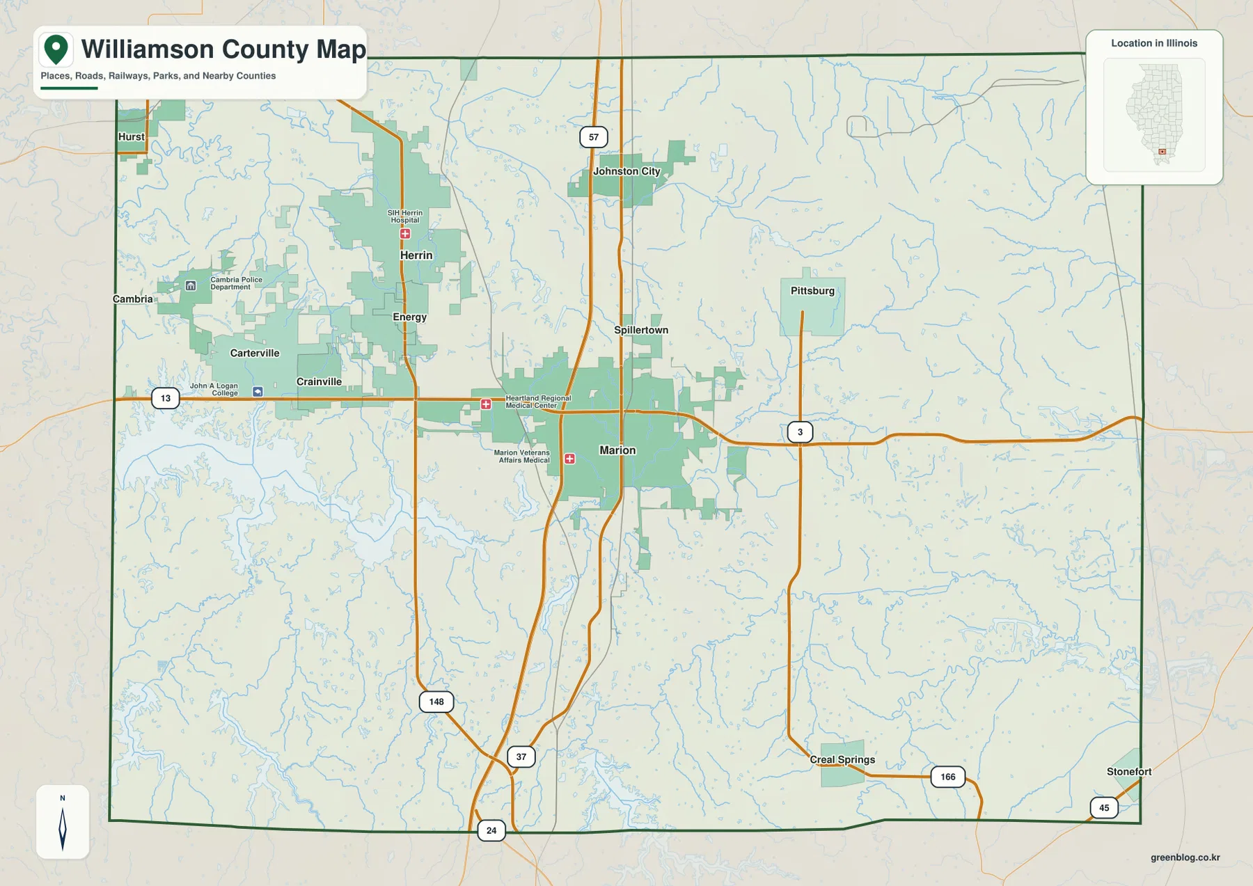
The western half of the map is more tightly linked by named towns and state routes than the far eastern side. Carterville and Crainville sit almost in sequence along Route 13, Herrin is just to their north, and Marion is the next major center to the east. By contrast, Pittsburg, Creal Springs, and Stonefort are separated by larger areas filled with streams and local roads. That contrast is useful for judging general direction and settlement spacing, although the map is not intended to provide current travel times, traffic conditions, or construction information.
The official Williamson County government site also describes the county as being located at the intersection of Interstates 24 and 57 and Illinois Route 13. Those three routes are all visible in the supplied map and help explain why Marion works so well as the page’s main road reference. For trip planning, current road information should still be checked separately. For geographic orientation, however, the county map quickly shows how the central road network connects Marion with the towns to its north and west and with the more widely spaced communities to the south and east.
A compact northwestern city cluster from Herrin to Carterville
The city-distribution map strips away much of the road detail and emphasizes six ranked places. Marion is listed first, followed by Herrin, Carterville, Johnston City, Crainville, and Cambria. The map’s own index gives reference figures of 16,836 for Marion, 12,226 for Herrin, 5,818 for Carterville, 3,627 for Johnston City, 1,641 for Crainville, and 1,300 for Cambria. These values are best treated as the figures used by this map package for ranking the places rather than as a substitute for the newest population estimates.
What matters most visually is the concentration. Herrin, Carterville, Crainville, and Cambria are all west or northwest of Marion, while Johnston City is north of Marion closer to the I-57 line. The eastern and southeastern parts of Williamson County do not contain one of the six ranked places shown on this simplified map. When the city map is compared with the full county map, Pittsburg, Creal Springs, Stonefort, and other smaller places fill some of that apparent empty space, but the contrast between the compact western-central settlement cluster and the more open east remains clear.
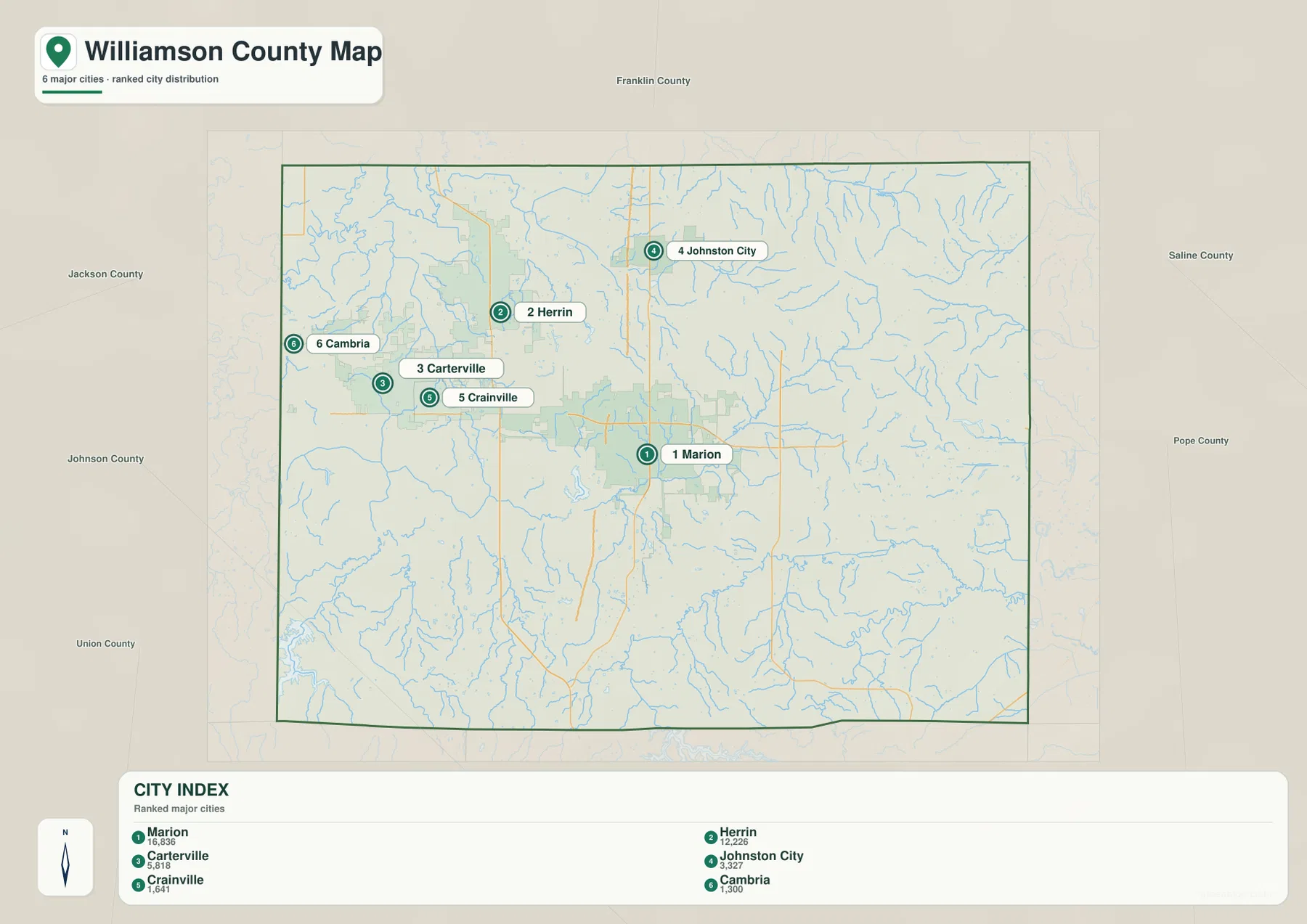
Surrounding county names are printed outside the Williamson County boundary, including Franklin, Saline, Pope, Johnson, Union, and Jackson counties. That context helps place the county within southern Illinois without adding extra local road detail. Inside the boundary, the ranked city markers are especially useful for understanding where the largest labeled population centers in this package sit relative to one another. Marion anchors the center, Herrin and Carterville form part of the nearby western cluster, and Johnston City extends the pattern northward.
This city map does not show connector lines or driving distances between the ranked places. It should therefore be used to compare direction and relative position, not to calculate mileage or trip time. A practical approach is to learn the six city positions here first, then switch back to the full county map to see how Route 13, I-57, Route 148, and Route 37 connect those same places. That two-step view keeps the city pattern readable without losing the road context.
Crab Orchard Lake and a water network that changes across the county
Crab Orchard Lake is the dominant water feature on the western side of the terrain-and-water map. Its irregular shoreline occupies a broad area near the county’s western edge, making it a strong landmark when comparing the water map with the road map. South of it, Grassy Creek leads toward Devils Kitchen Lake. Herrin Reservoir lies farther north, while Herrin Lake appears to the south of the central-western settlement area. Near the county’s southern edge, Lake of Egypt forms another large body of water, separate from the western lake group.
The river and creek system adds a different structure. Big Muddy River is labeled in the northwest, with Pond Creek nearby. Crab Orchard Creek runs across the central-eastern part of the county and becomes one of the stronger named stream lines on the map. South Fork Saline River curves through the southeastern half, joined by smaller tributaries including Sugar Creek. Johnston City Lake and Marion Reservoir add smaller water landmarks close to the developed central corridor, showing that the county’s water features are not confined to its outer rural areas.
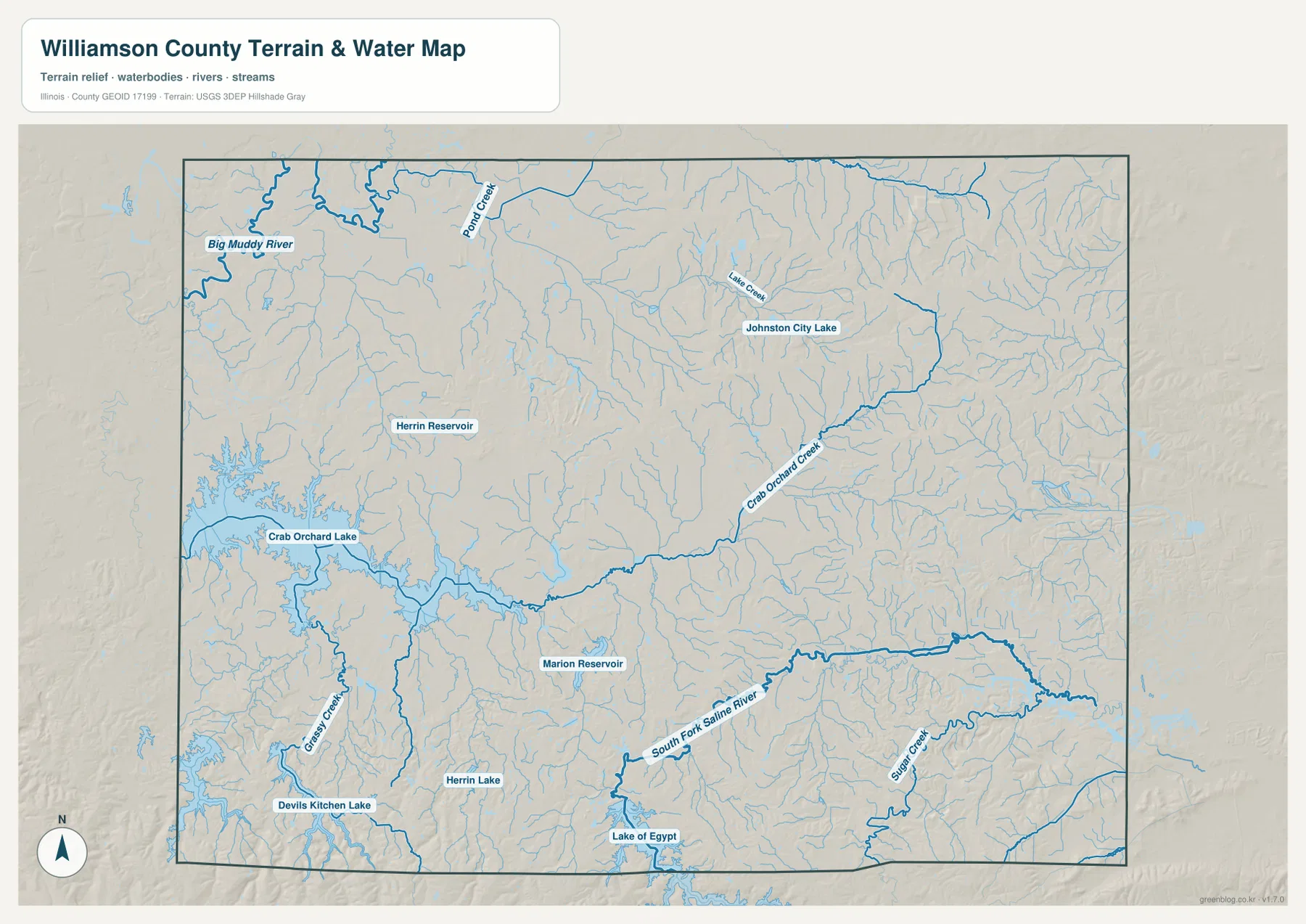
The western lakes are also part of a broader natural setting. The U.S. Fish and Wildlife Service notes that Crab Orchard National Wildlife Refuge includes lands in Williamson, Jackson, and Union counties, with lakes, wetlands, forest, cropland, prairie, and other habitats. That official refuge information provides useful regional context for the large water features on the western side of the map. The map itself, however, should still be read as a geographic reference: it shows where water bodies and streams are located, not the exact boundary of every habitat or protected management unit.
This is not a flood-risk, depth, navigation, parcel, or legal-boundary map. A thick blue line does not mean that a location is necessarily flood-prone, and the lake shapes do not provide information about depth, boating access, or shoreline ownership. The most appropriate use is to compare the position of Crab Orchard Lake, Lake of Egypt, Big Muddy River, South Fork Saline River, and the smaller reservoirs with the towns and roads shown on the other maps. Specialized water-management or flood decisions require dedicated official data.
From 107 m low ground to 219 m southern and eastern ridges
The elevation map shows an actual county range of roughly 107 to 219 meters, with a mean around 142 meters. Darker greens mark the lower end of the local scale, while pale yellow and brown tones indicate higher ground. Much of the central and western part of Williamson County appears green, creating a broad lower landscape around the Marion-Herrin corridor and the western lake area. The strongest brown colors occur toward the southwest and along parts of the southern edge, where more pronounced ridges rise above the lower interior.
The east and northeast also contain a complicated pattern of ridges and narrow valleys rather than one uniform high plateau. Brown and yellow bands break into many small branches, while green strips trace lower drainage corridors between them. In the southeast, those lower valleys line up well with the dense stream network visible on the water map. The relationship is particularly useful because the elevation map explains why the water map contains so many branching channels: streams follow lower ground between the surrounding hills.
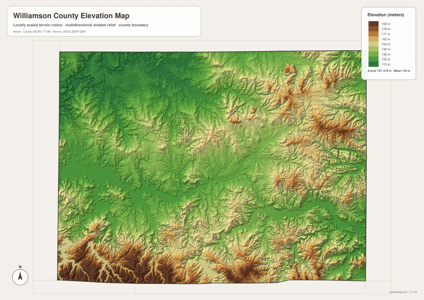
The western side is not uniformly low either. Near the southwest corner, high terrain rises sharply close to lower land around the Crab Orchard Lake area, creating one of the clearest color contrasts on the map. Along the southern border, repeated ridges and valleys create a much rougher appearance than the smoother central corridor. The pattern helps explain why a county that can look fairly simple on a road map becomes much more varied when elevation is added.
This surface is intended for county-scale comparison, not survey-grade measurement. It is useful for seeing that the middle of the county is generally lower and smoother than some of the southern and eastern hills, but it should not be used to assign an exact elevation to a building, road centerline, or parcel. Engineering, drainage, construction, and boundary work require more detailed elevation data or field surveying. For general map reading, the 107–219 m range is enough to show the main relief differences clearly.
Choosing the Williamson County map that fits the question
Use the full county map when the question is about Marion, Herrin, Carterville, Johnston City, Creal Springs, or another community in relation to the highway network. Route 13 and I-57 provide the quickest orientation, and Route 148 and Route 37 add detail for the western and central corridors. If the road labels feel too busy, the ranked city map is a cleaner way to learn the positions of Marion, Herrin, Carterville, Johnston City, Crainville, and Cambria before returning to the more detailed county map.
Use the water-and-terrain map when Crab Orchard Lake, Devils Kitchen Lake, Lake of Egypt, Big Muddy River, Crab Orchard Creek, or South Fork Saline River is the main subject. It makes the branching stream system much easier to see than the road map does. When the goal is to understand why some of those channels occupy narrow valleys or why the southern edge looks rougher, pair the water map with the elevation map. The green lowlands and brown ridges add a vertical dimension that the city and road maps do not show.
The WebP images on the page are sized for convenient online viewing. The ZIP below contains the corresponding high-resolution JPG originals, each at 3638 × 2572 pixels. Those files are better suited to printing, close inspection of labels, or keeping an offline copy. Because the maps emphasize different information, it is usually clearer to choose the road, city, water, or elevation version that matches the task instead of trying to treat one map as a complete source for every question.
Frequently Asked Questions
Which map is best for comparing Marion with Herrin, Carterville, and Johnston City?
The full county map is best when roads matter because it shows Marion at the I-57 and Route 13 crossroads, Carterville and Crainville to the west, Herrin to the northwest, and Johnston City to the north. If you only need a cleaner comparison of the main place locations, use the ranked city map first. It highlights six major places without the same amount of road detail, then you can return to the full map to see how the highways connect them.
How do Crab Orchard Lake and Lake of Egypt differ on the water map?
Crab Orchard Lake is a broad, irregular water body on the western side of Williamson County, while Lake of Egypt appears near the southern edge. Devils Kitchen Lake, Herrin Lake, Marion Reservoir, and other smaller water bodies lie between or around those larger landmarks. The water map is useful for comparing their positions, but it does not provide navigation routes, water depth, shoreline ownership, or a detailed hydrologic connection analysis.
Does the 107–219 m elevation range give the exact height of individual properties?
No. The 107–219 m range summarizes the county-scale elevation surface shown by the map. It is useful for seeing lower central and western areas and the higher ridges in the south and east, but it is not survey-grade elevation data for a parcel, building, or road. Engineering, drainage, or construction work should use more detailed official elevation data and, when necessary, field surveying.
Map File Information
This ZIP contains the high-resolution JPG originals for the Williamson County road and boundary map, ranked city map, water and terrain map, and elevation map. Review the web maps first, then download the originals for printing or closer inspection.
- Included Files: 4 high-resolution JPG maps
- Printable Size: 3638 × 2572 px each
Related Maps
Sources and References
- Williamson County official government site – county information and major transportation context
- U.S. Fish & Wildlife Service: Crab Orchard National Wildlife Refuge – regional refuge, lake, wetland, and habitat context
- U.S. Census Bureau TIGER/Line Shapefiles – county boundaries, roads, and place reference
- USGS National Hydrography – rivers, streams, and water features
- USGS 3D Elevation Program – elevation data
Green Map creates custom-edited map images using open geographic data sources such as geoBoundaries, Natural Earth, OpenStreetMap, and government open data.
These maps are edited visual materials, not raw data files, and are provided for education, documents, presentations, and graphic reference.