An Algeria Map reveals two administrative scales on one portrait page: a tightly divided Mediterranean north and a Sahara dominated by much larger wilayas. The supplied collection uses the same 69-wilaya framework in three forms—an unlabeled outline, a labeled black-and-white reference, and a labeled color version. That shared geometry lets readers move from recognition to comparison and then to annotation without changing the boundary system between activities.
The 69-unit total is date-sensitive. Algeria’s Law No. 26-06 of April 4, 2026 established the new territorial organization, and the measure appeared in Official Journal No. 25 dated April 5, 2026. Eleven former administrative districts became full wilayas, raising the national total from 58. A map that still shows 58 divisions represents an earlier system, even if its national border remains familiar.
Each supplied WEBP image measures 1200 × 1307 pixels. The labeled versions name all 69 wilayas and place Morocco, Western Sahara, Mauritania, Mali, Niger, Libya, Tunisia, and the Mediterranean Sea around Algeria for orientation. They do not provide roads, city symbols, terrain, elevation, tourist sites, or travel routes. Use the set for current first-level administrative reference and visual projects, not navigation or legal surveying.
Table of Contents
Understanding the 2026 Algeria Map
The legal change matters because eleven names now identify full wilayas: Aflou, Barika, El Kantara, Bir El Ater, El Aricha, Ksar Chellala, Aïn Oussera, Messaad, Ksar El Boukhari, Bou Saâda, and El Abiodh Sidi Cheikh. The Ministry of the Interior described the reform as a 69-wilaya structure containing 1,541 communes. Romanized spellings may vary across official or English-language sources, so the article follows the labels printed on the supplied images.
Those additions are not distributed in one block. El Aricha appears in the northwest below Tlemcen and above Naâma near Morocco. Bir El Ater is visible along the eastern side below Tébessa, while El Kantara sits in the interior near Biskra. Aïn Oussera, Messaad, Ksar El Boukhari, Ksar Chellala, and Bou Saâda increase the number of units across the central northern interior, where an older map looks noticeably less divided.
To check whether an Algeria Map reflects the 2026 framework, do not rely only on a “current” caption. Look for the eleven names and confirm that each has its own boundary. El Aricha is a convenient visual test because its small area is distinct from Tlemcen and Naâma. The complete check is still more reliable, especially where several new wilayas sit near older units with similar-looking outlines.
Why the North and South Look So Different
The northern band carries many short boundary segments and compact labels. Provinces around Algiers—including Tipaza, Blida, Boumerdès, and Tizi Ouzou—occupy much less page area than the great southern units. From Tlemcen and Oran in the west toward Annaba and El Tarf in the east, the map must fit numerous names close to the Mediterranean coast without replacing them with a numbered key.
Moving south, the shapes expand dramatically. Tindouf, Adrar, Tamanrasset, Illizi, Ouargla, and Bordj Badji Mokhtar occupy broad fields across the Sahara. This size contrast is not a graphic effect or population scale: it reflects the mapped administrative areas. The labeled versions use larger type where space allows and much smaller type in the crowded north, so readers should zoom into the coast rather than assume a missing label.
The surrounding labels help explain the edge provinces. Morocco and Western Sahara appear to the west, Mauritania and Mali to the southwest and south, Niger to the southeast, and Libya and Tunisia to the east. The Mediterranean Sea runs across the top. These labels provide regional context, but the map does not trace disputed claims, maritime limits, border crossings, or road connections.
Outline Map for Annotation and Classroom Work
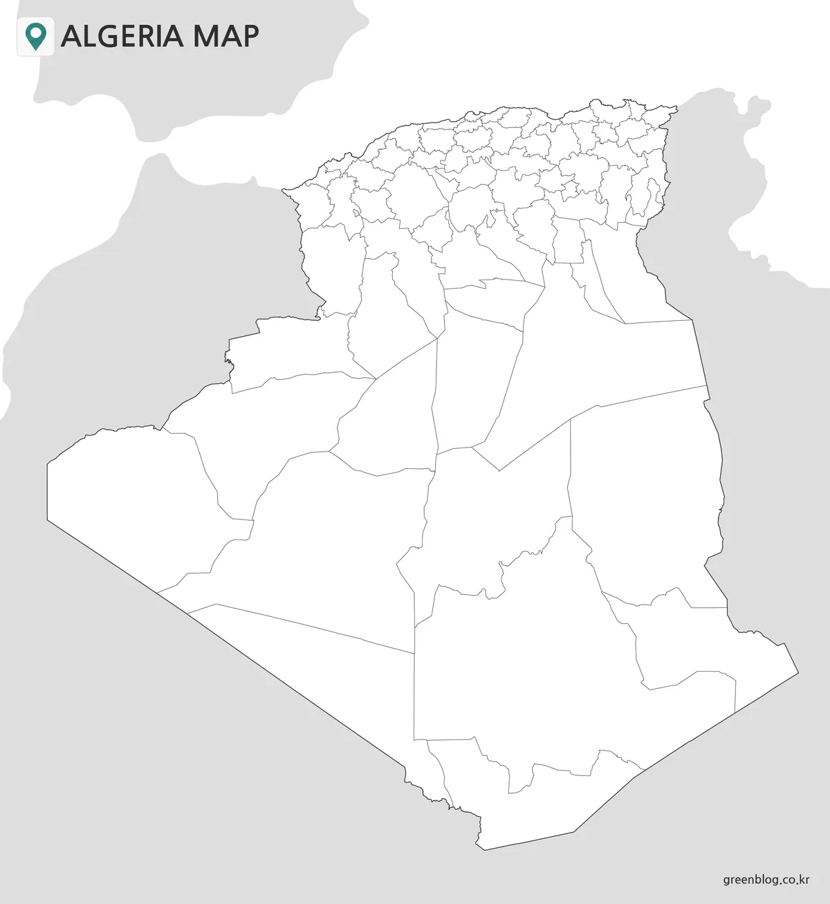
The outline Algeria Map removes all wilaya and neighboring-country labels while preserving the national edge and 69 internal divisions. Algeria remains white against light-gray surrounding land, and the sea is left white rather than filled blue. This spare treatment gives the dense coastal network as much room as possible and leaves the large Saharan interiors open for writing or color.
For a lesson, students can label only the eleven 2026 additions, identify border wilayas, or create separate northern and Saharan groups. A second activity can ask learners to place neighboring countries around the silhouette. Because the blank file retains no printed answer labels, it works best when paired with either labeled version as a reference or answer sheet.
The outline is a 1200 × 1307-pixel raster image, not an SVG or GIS dataset. Users can add text, markers, translucent fills, and simple overlays in an image editor, but the wilaya shapes are not delivered as independent vector objects. It is appropriate for educational graphics and annotation, not coordinate analysis, precise measurements, or legally authoritative boundary work.
Black-and-White Map for Names and Boundaries
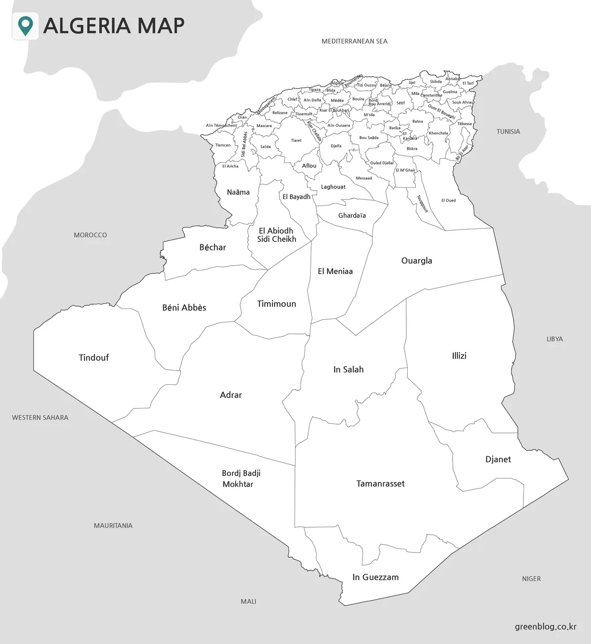
The monochrome version adds every wilaya name and the external orientation labels while keeping Algeria’s interior white. Large southern names such as Tamanrasset, Adrar, Illizi, Djanet, and Tindouf are immediately visible. Along the coast and Tell Atlas zone, smaller labels follow the compact units; enlarging this part of the page is essential when the map is used on a screen or reduced print.
This is the most direct reference sheet for name-finding. A reader can trace El Aricha below Tlemcen, locate Aflou above Laghouat, compare Messaad with Djelfa, or follow the eastern sequence around Barika, El Kantara, Biskra, and Bir El Ater. The absence of province fills reduces color dependence and makes hand-drawn circles, arrows, and short notes more visible.
Black and white does not mean low detail: the map still contains many fine boundaries and small names in the north. Before producing a class set, make one proof at the intended size and check Algiers, Boumerdès, Blida, and nearby labels. Portrait orientation should be retained so the long north-to-south outline is not distorted to fit a landscape page.
Color Map for Fast Regional Comparison
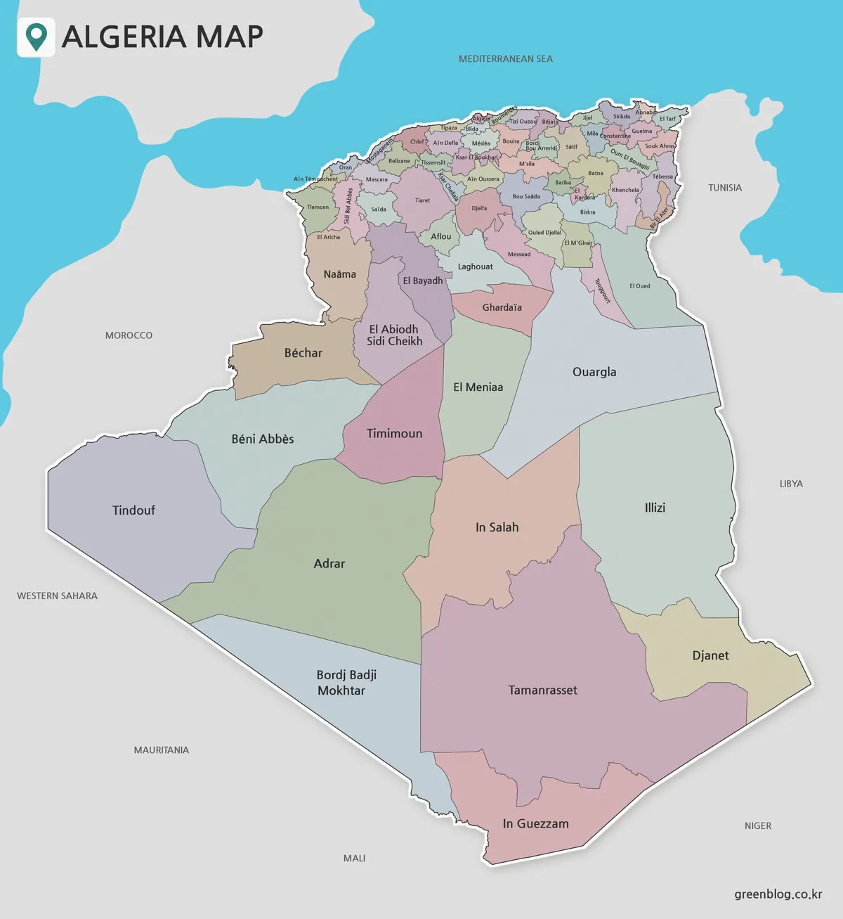
The color Algeria Map assigns muted contrasting fills to adjacent wilayas, adds a bright blue Mediterranean, and retains the complete label set. A light edge and shadow lift the national shape from the gray neighboring land. The palette has no thematic legend, so colors separate units visually; they do not represent population, climate, politics, language, resources, or elevation.
Color is especially helpful in the crowded northern belt, where a boundary line alone can be difficult to follow through several close labels. It also makes the enormous southern fields easy to compare at a glance. A presenter can move from the Mediterranean cluster through the High Plateaus toward the Sahara while the audience keeps track of each selected shape.
This version is suited to projected lessons, country profiles, blog graphics, and slides that introduce the national pattern. If it will be reproduced on a monochrome printer, test the result first because several pastel fills may convert to similar gray tones. Use the dedicated black-and-white image when reliable label contrast matters more than on-screen separation.
Choosing the Best Version for Your Project
Choose the labeled monochrome file when the task is to find names, cite locations in a report, or add handwritten notes. Choose the color Algeria Map when viewers must distinguish neighboring wilayas quickly on a slide or web page. Use the blank outline when learners or designers will supply labels, fills, symbols, or a custom legend themselves.
The three files can form a single teaching sequence. Introduce the 69-unit pattern with color, keep the labeled monochrome version available for checking, and distribute the outline for recall or categorization. Because the boundaries match across the set, the exercise changes without requiring students to relearn the shapes from a different source.
A map-selection decision should also account for scale. The color file is fast to scan at moderate size, but the black-and-white version may be clearer in printed text. The outline provides maximum writing room yet cannot answer name questions on its own. For any version, enlargement is preferable when the compact northern labels are central to the task.
Practical Ways to Use the Map Files
One high-value activity compares a 58-wilaya reference with this Algeria Map and asks students to locate the eleven additions. El Aricha offers a focused northwest example, while Aïn Oussera, Messaad, Ksar El Boukhari, Ksar Chellala, and Bou Saâda create a broader central comparison. Learners can describe which older units were divided without turning the page into a general history exercise.
Another activity uses the country’s edges. Students can match Tindouf with Western Sahara and Mauritania, connect Bordj Badji Mokhtar and In Guezzam with the southern borderlands, and locate Djanet and Illizi along the Libyan side. The result teaches relative position, but it should not be used to infer border-crossing roads or travel access because those features are absent.
For printing, preserve the 1200 × 1307 aspect ratio and use portrait orientation. Check a proof before a large run, especially if every coastal label must remain readable. The files are confirmed as WEBP images at the stated pixel dimensions; the archive does not establish an A3 print specification, vector format, or independently selectable administrative geometry.
Frequently Asked Questions
How many provinces are shown on the Algeria Map?
The maps show 69 provinces under Algeria’s 2026 territorial organization. The total increased from 58 after 11 administrative districts became full provinces. Their boundaries and names are included in the labeled black-and-white and color versions, while the outline version retains the same divisions without text.
How can I tell this apart from an older 58-province map?
Look for the 11 additions, including Aflou, Barika, El Kantara, Bir El Ater, El Aricha, Ksar Chellala, Aïn Oussera, Messaad, Ksar El Boukhari, Bou Saâda, and El Abiodh Sidi Cheikh. El Aricha should appear as a separate province south of Tlemcen and north of Naâma.
Which version is best for a school worksheet?
The outline map leaves the most space for student labels, colors, symbols, and short notes. If the worksheet requires students to locate names rather than recall them, the black-and-white version provides a clearer reference. Both use the same 69-province framework, so they can be paired in one activity.
Does the collection include roads, cities, or tourist attractions?
No. These are administrative maps centered on Algeria’s national outline, provincial boundaries, province names, and neighboring countries. They do not show road networks, attraction markers, terrain, or city-to-city travel routes. A separate road or travel map would be needed for navigation.
Can the outline image be edited like a vector map?
The outline is supplied as a 1200 × 1307-pixel WEBP image, not as an SVG or another vector source. You can add colors, text, markers, and overlays in an image editor, but the province shapes are not delivered as individually selectable vector objects.
Download the Algeria Map Files
Map File Information
The archive contains three administrative images using Algeria’s 69-wilaya framework under the 2026 territorial organization.
- Included Versions: Outline, labeled black and white, labeled color
- File Type: WEBP images
- Intended Use: Worksheets, presentations, reference graphics, coloring, and annotation
Related Maps
Additional Resources
- Algeria Press Service: New Territorial Organization Law — The national news agency confirms Law No. 26-06, its publication date, and the transition to 69 wilayas.
Green Map creates custom-edited map images using open geographic data sources such as geoBoundaries, Natural Earth, OpenStreetMap, and government open data. These maps are edited visual materials, not raw data files, and are provided for education, documents, presentations, and graphic reference.