The Niger Map collection shows a country whose administrative pattern is shaped by an extreme contrast in scale. Agadez occupies most of the north, while Niamey and several much smaller divisions cluster along the more populated southern belt. Seeing those areas together makes it easier to understand why a simple national outline cannot explain how Niger’s territory is organized.
Niger is a landlocked West African country covering about 1.267 million square kilometers. Algeria and Libya lie to the north, Chad to the east, Nigeria and Benin to the south, and Burkina Faso and Mali to the west. Much of the north and center falls within the Sahara, while the southern part reaches into the Sahel and contains most of the country’s major population and farming areas. The capital, Niamey, sits in the southwest beside the Niger River, although the river itself is not drawn in this administrative set.
Three images are provided in the order shown on the page: an unlabeled outline, a labeled black-and-white reference, and a color-coded administrative version. Each preview measures 1200 × 849 pixels and uses WEBP format. The maps are intended for regional study, classroom labeling, presentations, country comparisons, document graphics, and reader-added statistics rather than road navigation, terrain analysis, or detailed city planning.
Table of Contents
Reading the Niger Map from the Sahara to the Southern Border
The broad northern shape belongs mainly to Agadez, a region associated with the Aïr Mountains and the Ténéré section of the Sahara. Its size dominates the page and creates a strong contrast with the narrow sequence of divisions near Nigeria. This is not simply a design effect: northern Niger covers an immense area, whereas settlement and agricultural activity are more concentrated farther south.
Tahoua forms a transition between Agadez and the smaller southern divisions. Maradi and Zinder extend along the Nigerian side of the border, while Diffa reaches the southeastern corner between Nigeria and Chad. In the west, Tillabéri touches Mali and Burkina Faso, and Dosso reaches toward Benin and Nigeria. Niamey appears as a very small capital district enclosed within the southwestern area of Tillabéri and close to the boundary with Dosso.
The surrounding country names are important because Niger borders seven states but has no coastline. Nigeria forms the long southern neighbor, while the short Benin boundary is visible near the southwestern projection. Libya occupies only a relatively short section of the northeast, and the borders with Algeria and Chad frame the enormous northern and eastern sides of the country.
Eight Divisions Shown in the Supplied Maps
The supplied Niger Map uses the established arrangement of seven regions plus the separately administered capital district of Niamey. The labeled files identify Agadez, Diffa, Dosso, Maradi, Tahoua, Tillabéri, Zinder, and Niamey. They are first-level divisions for this map; smaller departments and communes are not included.
| Division | Type in This Map | Position and Visual Character |
|---|---|---|
| Agadez | Region | Vast northern division occupying more than half of the mapped country |
| Diffa | Region | Southeastern area bordering Chad and Nigeria |
| Dosso | Region | Compact southwestern region beside Benin and Nigeria |
| Maradi | Region | Small south-central division along the Nigerian border |
| Niamey | Capital district | Very small southwestern unit within the Tillabéri area |
| Tahoua | Region | West-central transition between Agadez and the southern belt |
| Tillabéri | Region | Western region bordering Mali and Burkina Faso |
| Zinder | Region | Broad southeastern division between Maradi and Diffa |
Tillabéri commonly appears with the accent shown here, although Tillaberi is also used when software or filenames omit diacritical marks. Niamey requires separate attention because it is not merely a city label placed inside another region. Its tiny polygon represents a capital-level administrative unit, which is why it remains distinct on both the outline and color maps.
An Outline for Labels, Categories, and Reader-Added Data
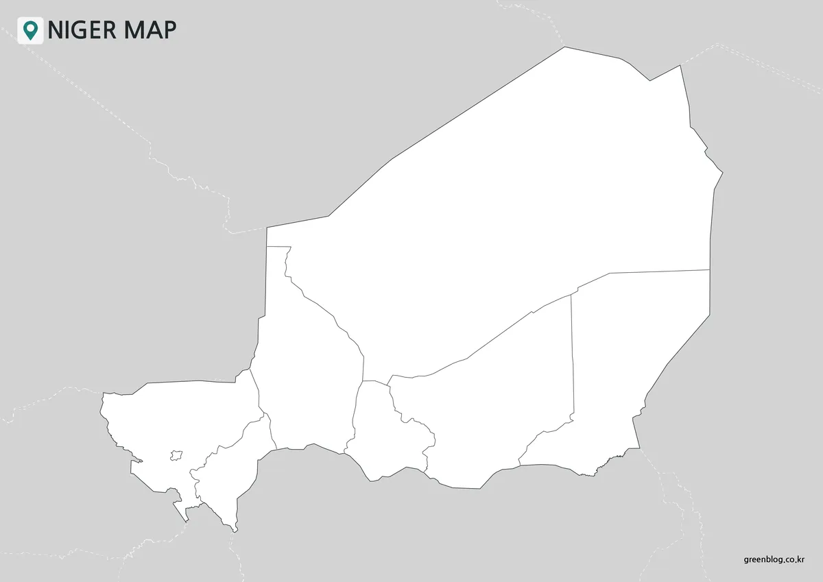
The first Niger Map removes all regional names and color fills while retaining the national boundary and the internal lines for eight divisions. Faint border context remains outside the country, but neighboring states are not named. This version turns the page into an open activity base rather than a completed reference.
Students can label the seven regions, mark Niamey, and add the names of all seven neighboring countries. For a climate exercise, the broad Sahara and the narrower Sahelian belt can be shaded separately. A data project might assign colors to population, rainfall, agriculture, or land use, provided those values come from an appropriate outside source.
A Labeled Reference without Regional Fills
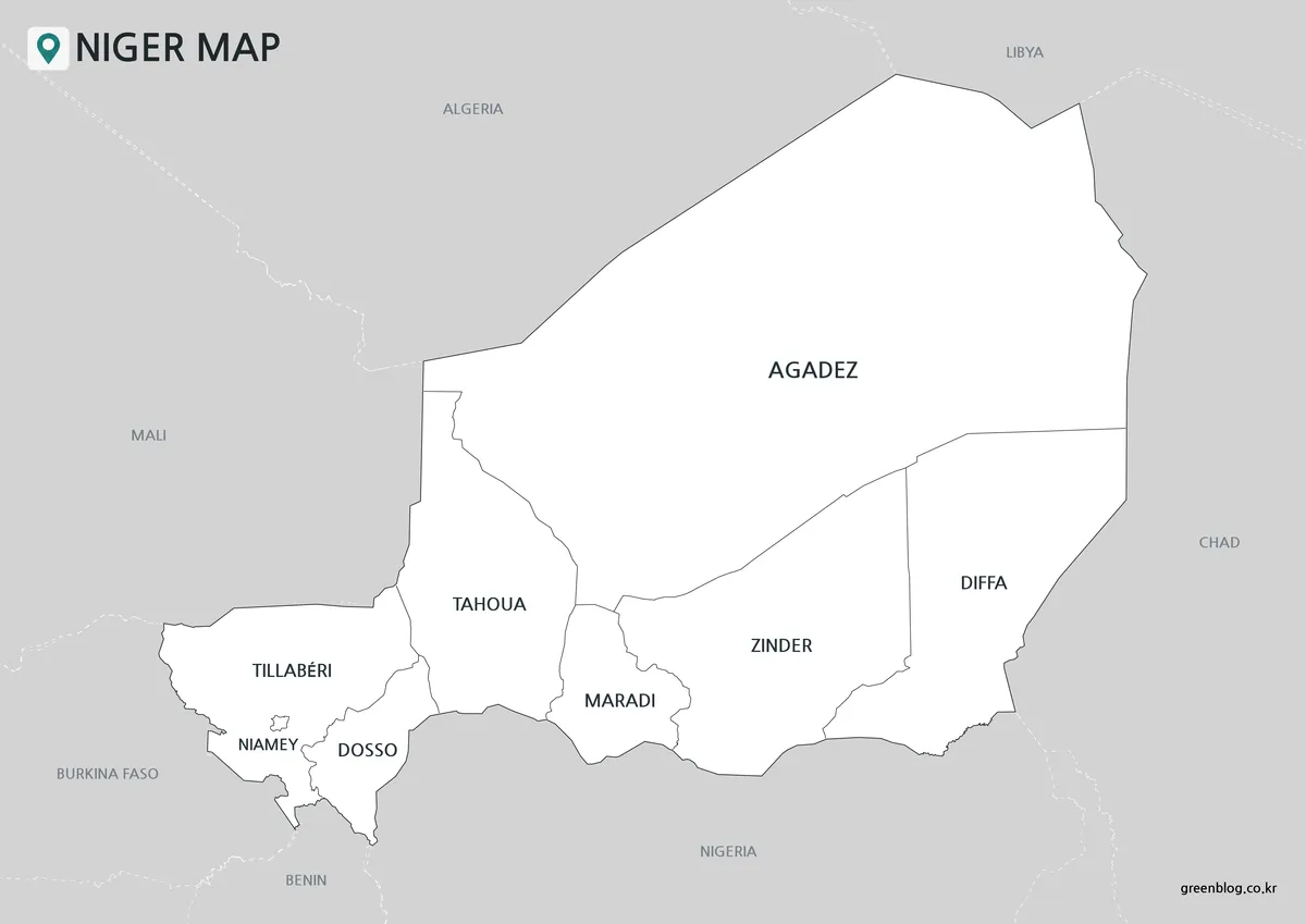
The second Niger Map keeps the country white and adds the names of the eight divisions and seven surrounding countries. Agadez, Zinder, and Diffa have enough open space for direct labels, while Niamey, Dosso, and Maradi demonstrate how tightly the smaller southern units fit together. The restrained treatment makes spelling and relative position the main focus.
This version is a practical answer key for a labeling worksheet and a clear insert for reports that do not need regional colors. It also helps prevent a common naming mistake: Niger is the mapped country, while Nigeria is its much larger southern neighbor. No roads, rivers, regional capitals, or elevation shading are shown, so the image remains an administrative reference rather than a general-purpose atlas map.
Color Separation for Comparing Unequal Regions
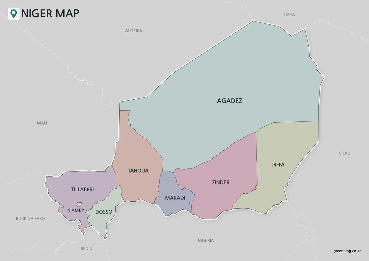
In the third Niger Map, muted fills separate each division without coloring the surrounding states. The visual hierarchy becomes immediate: Agadez spans most of the upper map, Zinder and Diffa cover substantial eastern areas, and Niamey appears as a tiny contrasting shape in the southwest. Soft colors preserve the boundary lines and labels instead of competing with them.
The color edition suits slides explaining the contrast between the Saharan north and the southern population belt. It can also introduce a regional statistics graphic before a more detailed chart is shown. Because the fills represent administrative divisions rather than climate zones, they should not be interpreted as vegetation, rainfall, or terrain categories.
A Time-Sensitive Note on the 2026 Redistricting Proposal
These images document the eight-unit structure described above. In May 2026, Nigerien authorities presented a proposal to reorganize the country from eight regions or equivalent units into 19 regions, with additional changes to departments and administrative centers. Reports available with the proposal describe a planned redivision rather than a complete set of final, implemented boundaries.
That distinction matters when using a Niger Map with recent statistics or government documents. The files remain suitable for explaining the earlier seven-region-plus-Niamey framework, but they should not be presented as a map of finalized 19-region boundaries. If the proposed system is formally adopted and authoritative boundary maps are released, a new edition will be needed rather than simply renaming the existing polygons.
Choosing a Version for the Task
Choose the labeled Niger Map when readers need a ready reference and must locate a region without consulting another sheet. Select the color edition when differences in area and adjacency need to be understood quickly on a screen. Use the outline when the assignment depends on active labeling, custom categories, or colors supplied by the reader.
The 1200 × 849 previews share the same landscape proportions, allowing the three versions to be compared without a change in geometry. When placing one in a document, check the small Niamey area at the intended display size. If that shape becomes difficult to distinguish, the map should be shown wider rather than cropped away from the southwestern border.
Practical Study and Presentation Ideas
A regional geography lesson can use the Niger Map to trace all seven international borders and compare the enormous north with the compact southern divisions. Another exercise can ask why Niamey requires its own polygon and why Nigeria appears outside the national outline despite the similarity of the two country names.
For presentation work, the color map can introduce the administrative framework before separate slides discuss the Sahara, the Sahel, the Niger River corridor, or the Lake Chad side of Diffa. The outline image is better for adding verified regional values, proposed travel routes, or study notes because it does not compete with preprinted names or fills.
Frequently Asked Questions
How many divisions appear on the Niger Map?
The files show eight first-level units: the seven regions of Agadez, Diffa, Dosso, Maradi, Tahoua, Tillabéri, and Zinder, plus the capital district of Niamey. Smaller departments and communes are outside the scope of this collection. The 2026 proposal for 19 regions is discussed separately because these images do not show its proposed new boundaries.
Why is Agadez so much larger than the southern regions?
Agadez covers much of northern Niger, including extensive Saharan territory. By contrast, several southern divisions occupy smaller areas near the Nigerian border, where population and farming are more concentrated. The large northern polygon and compressed southern belt therefore reflect an important geographic and administrative difference rather than inconsistent map scaling.
Is Niamey part of Tillabéri Region?
Niamey is shown as a separate capital district, not as an ordinary city marker within Tillabéri. Its small polygon is surrounded by the southwestern Tillabéri area and lies close to Dosso. The national capital stands on the Niger River, but this map set does not include the river line.
Which image should I use for a classroom worksheet?
Use the outline for an activity in which students add regional names, neighbors, or category colors. The labeled black-and-white image can serve as the reference or answer key. The color version is more effective when the lesson begins with a quick visual comparison of the unequal regional areas.
Do the maps include roads, cities, rivers, or elevation?
No. The collection focuses on national and first-level administrative boundaries. Niamey appears as an administrative area rather than a point symbol, and the other regional capitals are not marked. A transport, hydrographic, physical, or city map should be consulted when those features are required.
Map File Information
This set contains three Niger administrative map images for regional reference, classroom activities, presentation graphics, and reader-added labels or data.
- Included Versions: Outline map, labeled black-and-white map, and color map
- Preview Dimensions: 1200 × 849 pixels
- File Type: WEBP images
- Boundary Framework: Seven regions and the Niamey capital district
- Intended Use: Study sheets, presentations, document graphics, labeling, and regional comparison
Related Maps
Additional Resources
- Nigerien Press Agency: 2026 Administrative Redistricting Proposal: Read the Nigerien agency’s report on the proposal to expand the administrative structure from eight to 19 regions.
Green Map creates custom-edited map images using open geographic data sources such as geoBoundaries, Natural Earth, OpenStreetMap, and government open data. These maps are edited visual materials, not raw data files, and are provided for education, documents, presentations, and graphic reference.