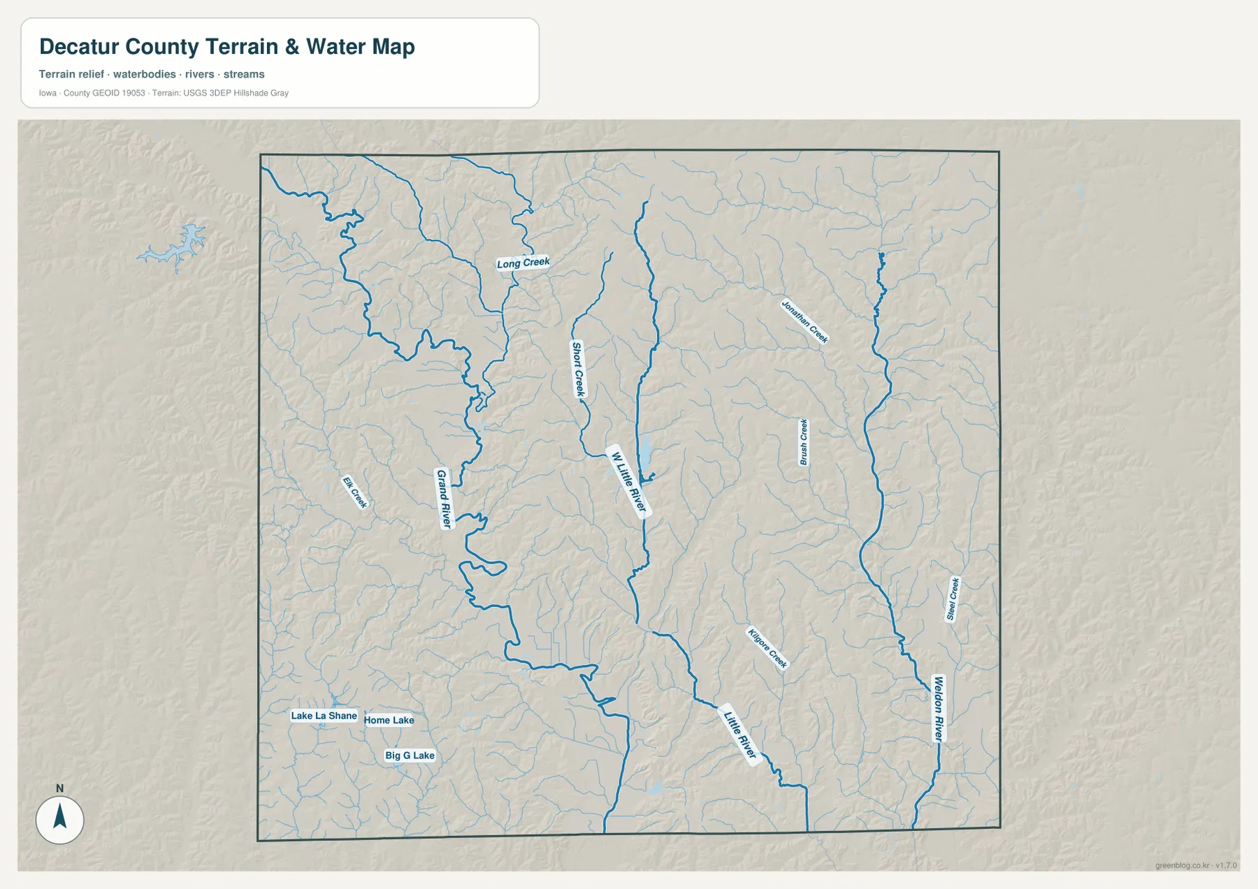
Decatur County sits in southern Iowa, where Leon and Lamoni anchor a network of smaller communities spread across rolling ridges and deeply branched stream valleys. The county overview uses Interstate 35, U.S. 69, and Iowa 2 as the clearest road references, while the terrain-and-water map shows Grand River on the west, W. Little River through the middle, Little River toward the southeast, and Weldon River on the east. The elevation surface ranges from 262 to 366 meters with a mean of 319 meters, so the lower green corridors along rivers stand out clearly against higher brown and orange uplands. The article images are WebP files for quick viewing, and the download box below provides high-resolution JPG versions in a ZIP archive.
A useful way to learn the county is to keep two settlement anchors in mind. Leon occupies the central part of the road network and lies along the Iowa 2 and U.S. 69 corridor, while Lamoni is well to the southwest near the southern edge of the county. Decatur, Van Wert, Garden Grove, and Grand River fill out the main city distribution farther north and around Leon. Once those places are familiar, the water and elevation maps explain why the county does not read as a flat grid: broad river bottoms, narrow tributary valleys, and higher ridges repeatedly interrupt the road pattern.
Table of Contents
Using Leon and the main highways to orient the county
Leon is the easiest first reference on the county map because several important routes meet or pass nearby. Iowa 2 runs east–west across the central part of Decatur County, linking the Leon area with Decatur to the west and communities farther east. U.S. 69 provides a north–south reference through the Leon–Van Wert side of the county, while Interstate 35 runs farther west. Together, those routes make it much easier to place Garden Grove and Grand River in the north, Davis City farther south, and Lamoni in the southwest without tracing every local road.
Decatur is shown just west of Leon, Van Wert lies to the north, Garden Grove sits toward the northeast, and Grand River is positioned in the northwest. Farther south, Davis City occupies the south-central portion of the map and Lamoni forms the strongest southwestern landmark. These locations are useful for general orientation rather than turn-by-turn navigation. Construction, closures, access points, and current travel times can change, so live road information should be checked separately when a trip depends on current conditions.
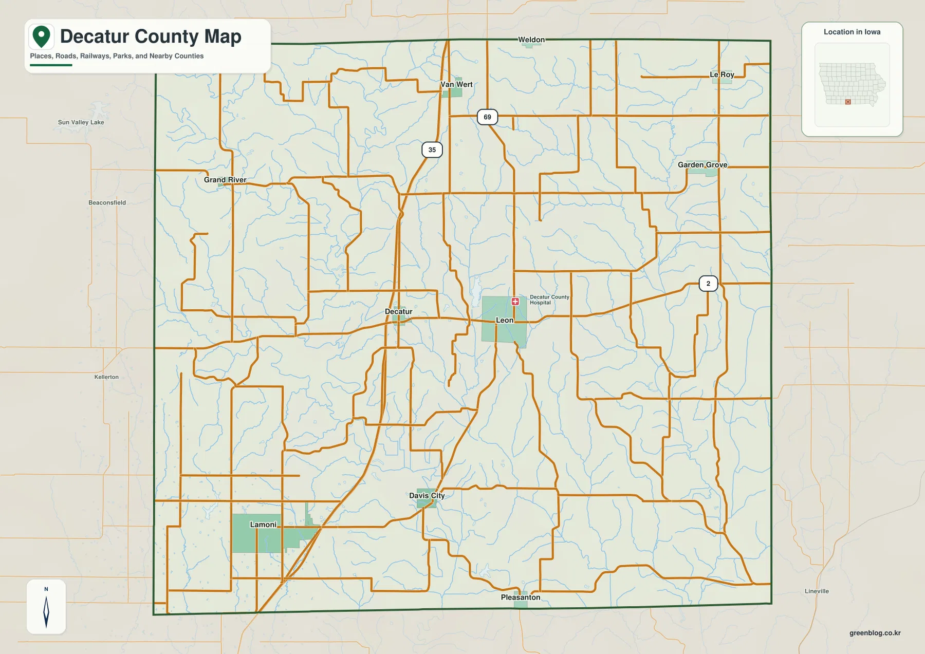
Names beyond the green county boundary also provide regional context. Weldon appears to the north, Lineville is shown beyond the southeastern side, and Beaconsfield and Kellerton provide references to the west. Pleasanton lies just beyond the southern edge. Those outside labels are useful for understanding where Decatur County sits within southern Iowa, but the purpose of this page is the county itself, so surrounding jurisdictions are not treated as extensions of the county map.
A six-city pattern led by Lamoni and Leon
The city-distribution map highlights six communities: Lamoni, Leon, Decatur, Van Wert, Garden Grove, and Grand River. Lamoni and Leon are the two dominant entries in the city index, but they occupy very different parts of the county. Lamoni is isolated in the southwest, while Leon is much closer to the middle of the county. The four smaller communities are scattered mainly around the central and northern portions, giving Decatur County a dispersed settlement pattern rather than one continuous urban corridor.
The northern group is especially easy to compare on the simplified map. Grand River lies toward the northwest, Van Wert is farther north near the center, and Garden Grove occupies the northeastern side. Decatur sits west of Leon and provides a short central comparison. Davis City appears on the detailed county map but is not part of the six ranked communities on the city-distribution graphic, which is a reminder that the two maps serve different purposes: one is a broad county reference and the other emphasizes a selected city hierarchy.
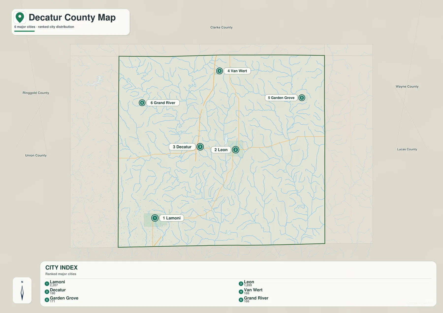
Keeping that city pattern in mind makes the terrain maps easier to read. The name Grand River appears both as a community and as a major river, so it is important to distinguish the settlement marker from the blue watercourse. Leon works well as a central road-and-settlement anchor, while Lamoni is a useful landmark for the southwestern lakes and valleys. Van Wert and Garden Grove help orient the more deeply dissected northern terrain where many small tributaries enter the larger river systems.
Grand River, Little River, and Weldon River divide the landscape
The terrain-and-water map shows several large drainage corridors rather than one dominant river. Grand River is the major western feature, entering from the northwest and bending repeatedly as it crosses the county. Long Creek and Elk Creek are among the named tributaries in that part of the map. Near the center, W. Little River runs north–south past a dense network of smaller channels, while Little River forms another major corridor farther southeast. Weldon River occupies the eastern side and creates a separate low valley near the county edge.
Smaller named streams help fill in the terrain between those larger rivers. Jonathan Creek appears in the northeastern interior, Bee Creek is labeled east of center, and Short Creek joins the central drainage pattern. The effect is a landscape cut into many narrow ridges and valleys instead of a broad undivided plain. Grand River has a comparatively wide lowland in places, while the central and eastern river systems produce longer, narrower corridors that extend southward through the county.
Lake La Shane, Home Lake, and Big G Lake are also labeled in the southwestern part of the water map. They make useful fixed landmarks when tracing the many nearby tributaries around the Lamoni side of the county. The map is intended for geographic reference, not for flood forecasting, water depth, boating navigation, shoreline access, or legal boundary decisions. Current recreation rules or access information should be checked with the appropriate management source when those details matter.
Elevation from 262 to 366 meters reveals a county of ridges and valleys
The elevation map reports an actual county range of about 262 to 366 meters and a mean of 319 meters. Higher brown and orange terrain covers large parts of the north, east, and southwest, while green lowlands follow the major rivers. The Grand River corridor creates one of the broadest western low areas. A second set of low green passages follows the W. Little River and Little River system through the central and southern parts of the county, and the Weldon River valley forms another clear low corridor in the east.
The uplands are not smooth plateaus. Small tributaries cut into them from many directions, producing a repeated pattern of narrow ridges separated by short valleys. The northeastern and eastern parts of the county show especially dense ridge-and-valley texture, while the southwest combines relatively high ground with steep local drops toward streams. Leon sits within a landscape of intermediate ridges and valleys rather than at one extreme of the elevation range, and the Lamoni area similarly contains quick changes between higher uplands and lower drainage corridors.
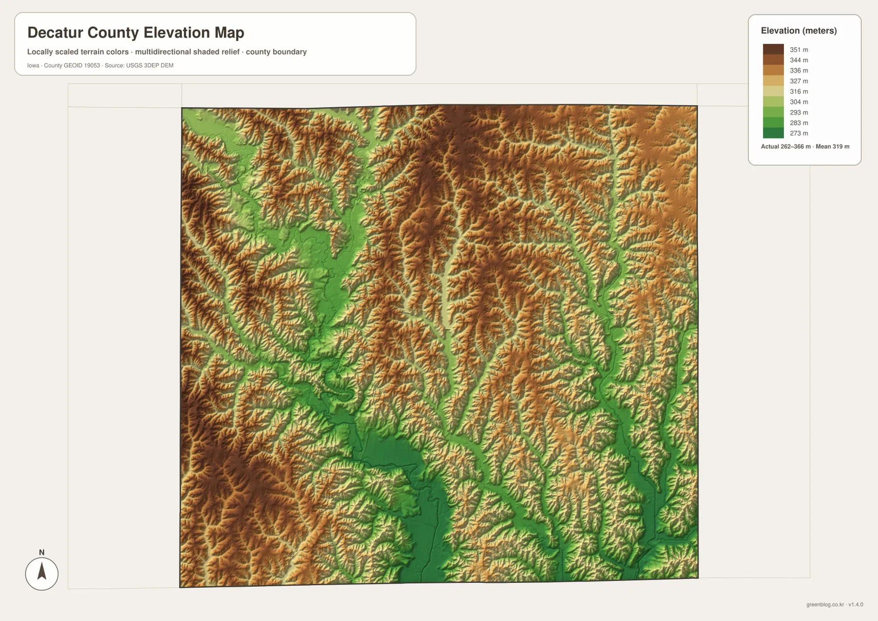
This generalized elevation surface is for county-scale comparison, not survey-grade measurement. Elevation can change within a single color band, and steep stream banks may vary over short distances. Property work, construction, drainage design, or any task that depends on exact elevation should use the original elevation data or professional surveying. Here, the map is most useful for understanding how the city and road pattern fits between the county’s ridges and river valleys.
Comparing the Leon side of the county with the Lamoni side
Leon provides a good central reference for connecting the road map to the drainage network. After locating Iowa 2 and U.S. 69, the reader can compare the broad Grand River lowland to the west with the W. Little River system nearer the center and the Weldon River corridor to the east. North of Leon, Van Wert and Garden Grove sit among a dense set of tributaries and closely spaced ridges. That northern terrain is more broken than the simple road grid might suggest, which becomes obvious only after the water and elevation maps are compared.
Lamoni offers a different perspective in the southwest. It is separated from the central cluster of communities and lies near several lakes and tributary valleys. The elevation map shows high ground in the southwest but also sharp local drops toward the drainage lines, so the area combines ridges and low channels over short distances. Moving east toward Davis City brings the reader closer to the broad south-central lowland associated with the Little River system. Using Leon and Lamoni as separate anchors makes it possible to learn the county in sections instead of treating every place name as part of one long list.
Distinguishing the town of Grand River from the river itself
One county-specific detail deserves special attention: Grand River is both the name of a community and the name of a major watercourse. The town of Grand River appears as a settlement in the northwestern road and city maps, while Grand River itself is drawn as a broad blue channel that bends through the western part of the county. The shared name can be confusing when a place is mentioned without context, but the map symbols make the difference clear: one is a city label and the other is a linear water feature.
This distinction becomes useful when the elevation map is added. Starting at the town marker and then tracing the actual river southward reveals a broad low corridor in the western terrain. Moving back toward Leon and Garden Grove takes the reader away from that western river valley and into different tributary systems. Recognizing the two meanings of Grand River therefore helps connect settlement geography, drainage, and elevation without mixing separate features that happen to share a name.
Choosing the Decatur County map for roads, cities, water, or relief
For overall orientation, begin with the county map and locate Leon, Lamoni, Interstate 35, U.S. 69, and Iowa 2. Those features provide enough structure to place Van Wert, Garden Grove, Grand River, Decatur, and Davis City. If the main goal is to compare settlements, the city-distribution map is cleaner because it removes most road detail and emphasizes the six selected communities. The contrast between Lamoni in the southwest and Leon near the center is especially useful for remembering the county’s broad layout.
For rivers and terrain, start with Grand River, W. Little River, Little River, and Weldon River, then add smaller streams such as Long Creek or Jonathan Creek. If elevation is the priority, look first at the 262–366 meter range and the 319 meter mean, identify the higher brown uplands, and then follow the green valleys back to the water map to name the corresponding rivers. Switching between the water and elevation maps turns the dense branching pattern into a set of recognizable drainage corridors rather than a collection of isolated lines.
The WebP images in the article are optimized for on-page viewing. The ZIP below contains separate high-resolution JPG versions of the county overview, city-distribution, terrain-and-water, and elevation maps for printing, classroom material, presentations, or closer visual reference. They are general geographic resources and do not replace legal boundary records, parcel data, live road conditions, flood information, or precise survey measurements.
Frequently Asked Questions
Which map is best for comparing Leon and Lamoni with the northern communities?
The city-distribution map is the quickest choice because it shows Lamoni, Leon, Decatur, Van Wert, Garden Grove, and Grand River without the full road network. Use the county overview next if you want to connect those places to Interstate 35, U.S. 69, and Iowa 2. The two maps together make the southwest–central–north settlement pattern much easier to remember.
What are the main waterways shown on the Decatur County water map?
Grand River dominates the western side, W. Little River runs through the central part of the county, Little River forms a major southeastern corridor, and Weldon River is prominent on the east. Long Creek, Short Creek, Jonathan Creek, Bee Creek, and other tributaries fill the ridges between them, while Lake La Shane, Home Lake, and Big G Lake are labeled in the southwest.
How should the 262–366 meter elevation range be interpreted?
The map shows a mean elevation of 319 meters, with higher orange and brown uplands across much of the north, east, and southwest. Lower green terrain follows Grand River and the Little River and Weldon River systems, creating long valleys between the ridges. The values are intended for county-scale comparison; exact elevations for a property, structure, or engineering task require the original elevation data or professional surveying.
Map File Information
The ZIP contains high-resolution JPG versions of the Decatur County overview, city-distribution, terrain-and-water, and elevation maps.
- Included Files: Use only the versions confirmed in the article and supplied images
- File Type: Use the confirmed download contents
- Intended Use: Printing, education, presentations, and map-based projects
Related Maps
Sources and reference data
The official links below provide the broader boundary, hydrography, and elevation datasets used for county-scale geographic reference. The maps on this page are simplified for regional understanding, so the original data should be consulted when a task requires exact geometry or elevation values.
These maps are general-reference resources for orientation, learning, printing, and presentation use. Legal boundaries, property ownership, current road conditions, flood hazards, and precise elevations should always be checked against the responsible agency’s current records and appropriate professional data.
Green Map creates custom-edited map images using open geographic data sources such as geoBoundaries, Natural Earth, OpenStreetMap, and government open data.
These maps are edited visual materials, not raw data files, and are provided for education, documents, presentations, and graphic reference.