Green County lies in south-central Kentucky, where Greensburg provides the clearest town reference and the Green River loops through a landscape of branching creeks and rolling ridges. The maps on this page show Greensburg and Summersville, numbered highways, named waterways, and an elevation range of about 148 to 317 meters. Four high-resolution JPG map files are also available in a ZIP download, making the set useful for printing, classroom work, and detailed local reference.
A good way to orient yourself is to start with Greensburg and then follow the Green River. Highways KY 61, 68, 70, and 88 spread from the Greensburg area, while the river bends repeatedly across the middle of the county and gathers water from many smaller valleys. The northern end narrows into closely spaced ridges, the central river corridor is lower, and the southern part rises again into rougher uplands. Seeing those elements together explains much of the county’s road and drainage pattern without treating the landscape as a simple grid.
Table of Contents
Greensburg anchors a road network that spreads into narrow valleys
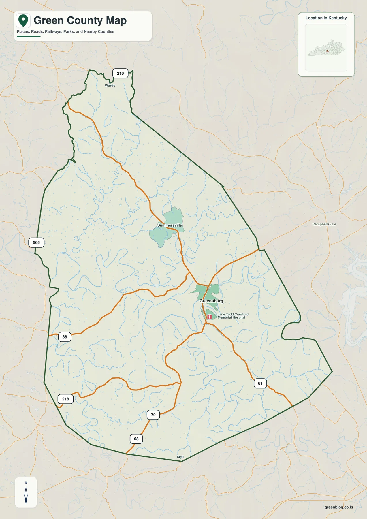
On the general county map, Greensburg sits a little south of the geographic center and stands out as the main road junction. KY 61 runs toward the southeastern boundary, while KY 70 creates a long connection between the south and northwest. KY 88 and KY 218 serve the western side, KY 566 appears near the western boundary farther north, and KY 210 crosses the narrow northern section. Together these roads provide a practical framework for locating places that are otherwise separated by ridges and small streams.
Summersville appears north of Greensburg and offers a second useful place-name reference. The two communities lie along the same broad north-south travel pattern, but their surroundings look different. Multiple roads converge around Greensburg and a hospital symbol reinforces its role as a service center, whereas the land north of Summersville shows fewer major roads and a denser mix of small drainage lines and hills. For a rural address or an unfamiliar road, it is usually easiest to identify one of these two places first and then work outward along the numbered highways.
The surrounding labels also help place Green County within Kentucky. Campbellsville is visible east of the county, while Adair, Metcalfe, Hart, Marion, Taylor, and Larue counties form the broader neighborhood shown around the map. Green County’s official website describes the county as a rural community in South Central Kentucky and notes that its land ranges from flat and gently rolling ground to steep, rocky terrain. That description matches the map well: low river corridors and short, steeper ridges occur within the same county boundary.
The major-city view puts Greensburg alone at the center of attention
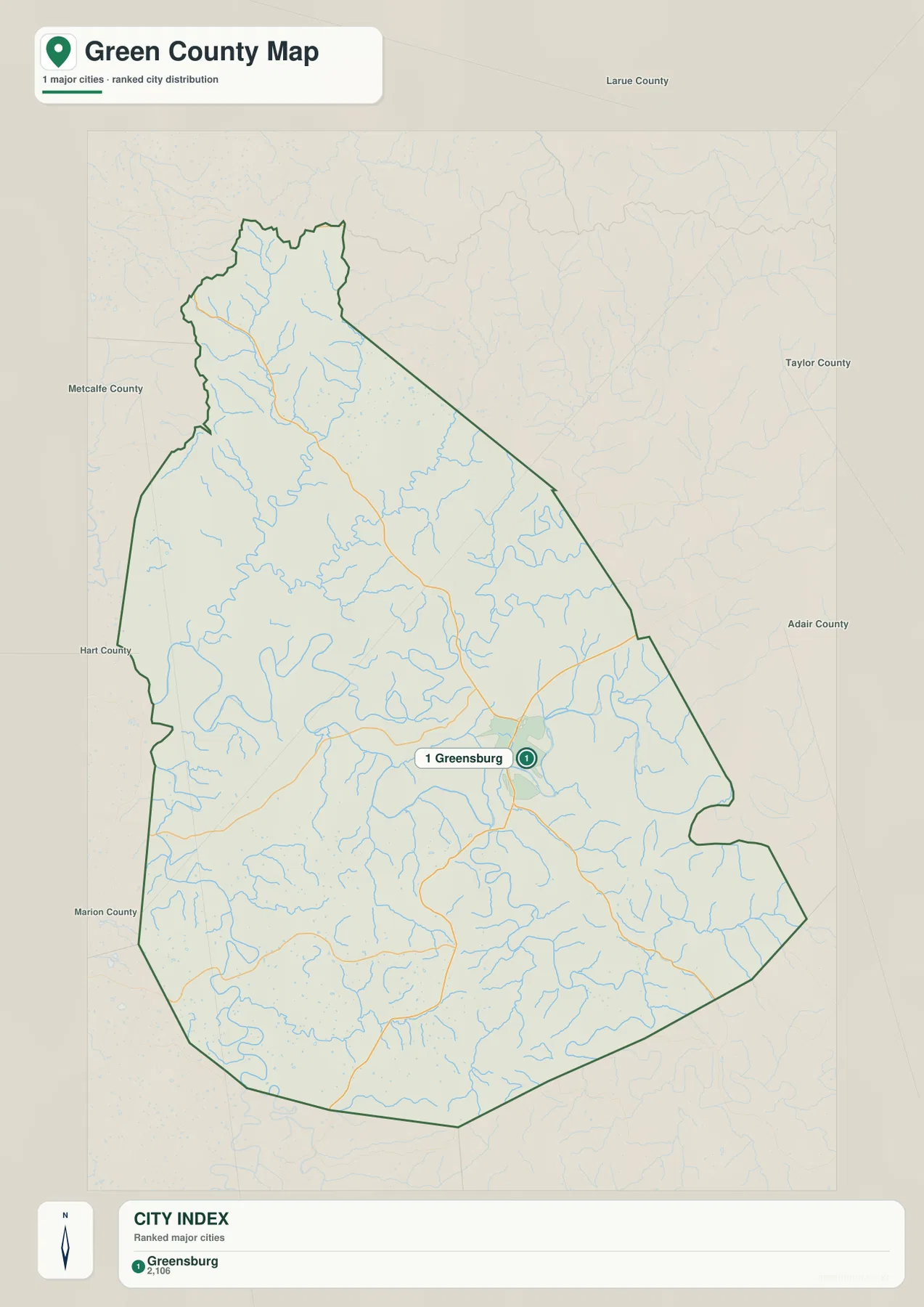
The city-index map is intentionally simpler than the general map. In this dataset, Greensburg is the only place shown as a ranked major city, so there are no connecting distance lines to other ranked cities inside the county. That makes the map useful for one specific question: where is the principal city relative to the full county outline? The marker sits south of center, leaving large rural areas to the north, west, and southeast.
Summersville still appears on the broader county map, but it is not included as a separate ranked city on this city-index version. The difference reflects the purpose of the two graphics rather than a contradiction. The general map keeps more roads and place labels for navigation context, while the city map strips away much of that detail to emphasize the selected major-city distribution. If you need a route from Greensburg toward Summersville or the county edge, use the city map for orientation and then switch to the general map for the road network.
Greensburg also sits close to one of the broad Green River bends. That relationship becomes clearer when the city map is compared with the water and elevation maps. Instead of occupying a high ridge crest, the city lies near a more open, lower part of the landscape where roads can spread into several surrounding valleys. In Green County, that connection between the main town, the river corridor, and nearby low ground is more informative than a simple list of communities.
Green River bends through the county while tributaries fill the side valleys
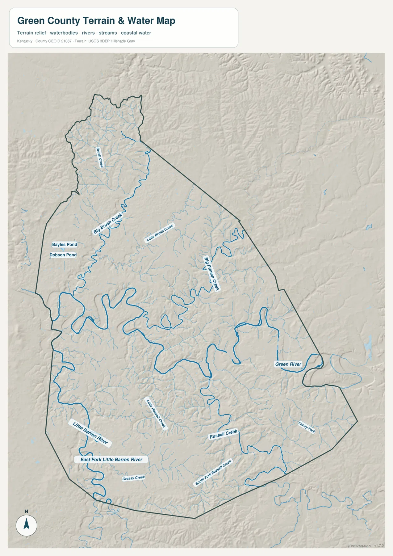
The Green River is the strongest feature on the terrain-and-water map. It enters from the east, curves repeatedly across the middle of the county, and continues westward through a broad series of bends. Because the channel does not follow a straight line, the associated low ground also forms long, irregular corridors. Green County’s official site highlights the Green River as one of the county’s defining natural resources, and the map makes clear why the river is such a strong geographic reference.
North of the main river, Big Pitman Creek follows a long valley, while Big Brush Creek and Little Brush Creek drain the northwestern interior. Smaller tributaries thread through the narrow northern end where ridges are packed more closely together. Bayles Pond and Dobson Pond are also labeled on the western side, giving the map a few small-waterbody references in addition to the larger river and creek network.
The southern half has a different set of named waterways. Russell Creek and South Fork Russell Creek cross winding valleys, and the Little Barren River with its East Fork appears in the southwest. Greasy Creek and Caney Fork add more detail near the southern boundary. These labels make the water map useful when a location is better known by a creek or valley name than by a town. The map is a static geographic reference, however, and should not be used for flood risk, current water level, navigation, or legal water-boundary decisions.
Elevation from 148 to 317 meters separates river bottoms from ridge country
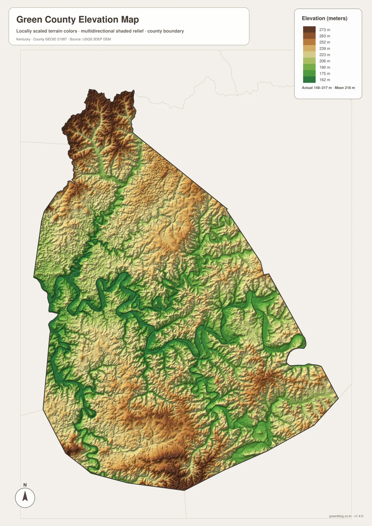
The elevation map shows an actual range of about 148 to 317 meters, with a countywide mean near 218 meters. The lowest green tones form long bands along the Green River and its major tributaries. Around the central river bends, those lower zones broaden noticeably and then narrow again as they follow side valleys. The close match between the water map and these low-elevation corridors makes the drainage pattern easier to understand.
The northern tip looks much rougher. Narrow ridges crowd the upper part of the county, and darker brown tones mark higher ground between the stream valleys. Higher terrain also reappears across the southern part of Green County, especially along ridge systems near the southern and southeastern boundary. Greensburg and the central Green River corridor, by comparison, occupy gentler colors that sit below many of the surrounding uplands.
This relief also helps explain why several roads curve as they leave Greensburg. A highway may maintain a broad direction, but creek crossings and short ridges force local bends that are not obvious on a simplified route diagram. The elevation image is designed for county-scale comparison rather than engineering measurement. It should not be treated as survey-grade elevation for a parcel, building site, road project, or other precise location.
Choose the map by whether you need roads, water names, or terrain contrast
For overall orientation, the general county map is the best starting point because it combines Greensburg, Summersville, the county boundary, and the main numbered roads. The city-index map is much cleaner when the only goal is to understand where Greensburg sits within the county. These two maps answer different questions: one supplies route context, while the other removes most secondary detail and emphasizes the main urban reference.
If your location is described by a creek, river bend, or nearby pond, the water-and-terrain map is more useful. Big Pitman Creek, Big Brush Creek, Russell Creek, the Little Barren River, and several smaller features are labeled directly. Pairing that map with the elevation view shows whether a named waterway occupies one of the broad low corridors or a narrower valley cut between higher ridges.
The downloadable JPG files are preferable when you need larger text, printed pages, or a closer look at fine map details. The WebP images on the page are optimized for quick viewing, while the ZIP contains the high-resolution versions of the general, city, water-and-terrain, and elevation maps. Comparing two maps side by side is often more informative than trying to extract every kind of information from a single graphic.
Frequently Asked Questions
Where should I start when locating roads and communities in Green County?
Start with Greensburg. It sits slightly south of the county center and is the clearest junction for KY 61, 68, 70, and 88. Summersville provides another useful reference to the north, while KY 210, 218, and 566 help orient the outer parts of the county. The general map is better than the city-index map when you need actual route context.
Can I see Green River and Little Barren River on the same map?
Yes. The terrain-and-water map labels the Green River across the central part of the county and shows the Little Barren River with its East Fork in the southwest. It also includes Big Pitman Creek, Brush Creek, Russell Creek, Greasy Creek, and other named tributaries, making it the most detailed option for water features.
Which parts of Green County appear lowest and highest on the elevation map?
The map reports an actual range of roughly 148 to 317 meters and a mean of about 218 meters. The lowest terrain follows the Green River and major tributary valleys, while higher ridges are especially visible in the narrow north and across parts of the south. For a precise site elevation, use official elevation data or a survey rather than this county overview.
Map File Information
Download the Green County general map, city map, terrain-and-water map, and elevation map as high-resolution JPG files.
- Included Files: Use only the versions confirmed in the article and supplied images
- File Type: Use the confirmed download contents
- Intended Use: Printing, education, presentations, and map-based projects
Related Maps
Sources and references
For local context, see the official Green County website and its About Green County page. Boundary and road references can be checked through U.S. Census Bureau TIGER/Line and Kentucky Transportation Cabinet Printable Maps. Water and elevation references are available from USGS National Hydrography and the USGS 3D Elevation Program.
Green Map creates custom-edited map images using open geographic data sources such as geoBoundaries, Natural Earth, OpenStreetMap, and government open data. These maps are edited visual materials, not raw data files, and are provided for education, documents, presentations, and graphic reference.