Koochiching County spans a large part of northern Minnesota along the Canadian border, with International Falls and Ranier concentrated in the northeast and Northome and Mizpah far to the southwest. Rainy River defines the northern edge, while Big Fork River and Little Fork River cross the broad interior toward it. Low northern terrain gives way to substantially higher hills in the south, creating a stronger relief contrast than the road map alone suggests.
This page uses the supplied county, city, water, and elevation maps to explain those local relationships with the actual roads, communities, rivers, bays, and terrain shown in the package. Original high-resolution JPG versions are also available together in one ZIP download for printing, classroom projects, presentations, or image editing.
Table of Contents
International Falls and Ranier anchor the northern border
International Falls is the clearest reference point on the general county map. Highway 53 enters the city from the south, while Highway 11 follows the northern part of the county along the Canadian border. Ranier lies immediately to the east near the Rainy River-Rainy Lake area, making the two communities the best starting points for understanding Koochiching County’s northeastern corner.
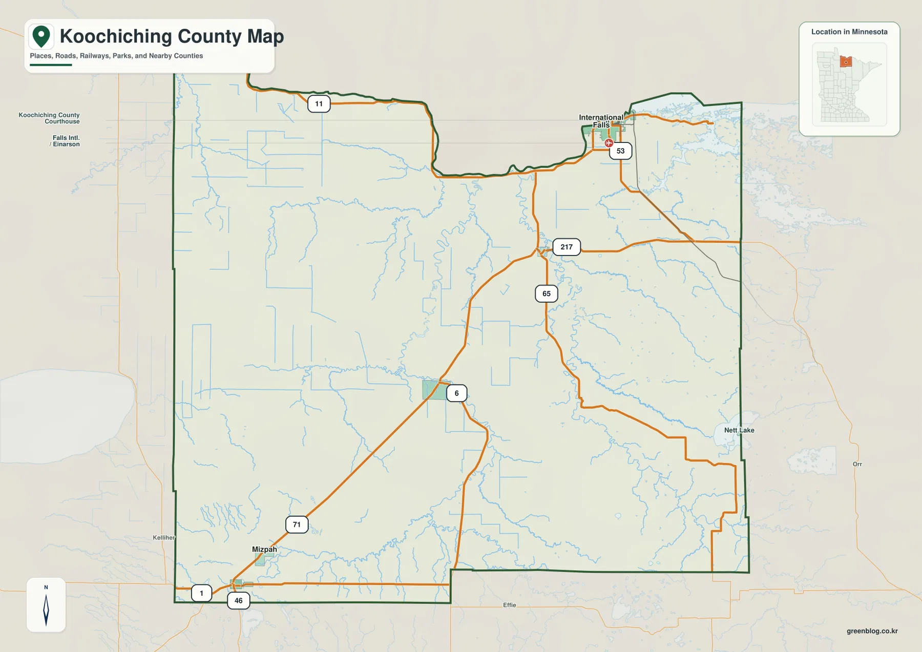
South of International Falls, Highway 53 meets Highway 217 and continues into the interior road network. Highways 65 and 6 serve the central county, where Littlefork and Big Falls provide widely spaced settlement references. The distance between named communities is immediately noticeable: this is not a county where towns form a continuous suburban or agricultural chain.
Northome and Mizpah occupy the southwestern side. Highway 71 approaches the Northome area, while Routes 1 and 46 meet near the southern boundary. Those communities are far removed from International Falls, so the same county includes a distinct southwestern road network separated from the northern border cities by long stretches of forest, wetlands, rivers, and lightly settled land.
Nett Lake appears toward the eastern side of the general map, while Lake of the Woods County and Beltrami County lie beyond the western and southwestern edges. Because Koochiching County is so large, roads, waterways, and the international boundary are more useful orientation tools than town names alone.
A city pattern stretching from International Falls to Northome
The city map highlights International Falls, Littlefork, Ranier, Northome, Big Falls, and Mizpah. International Falls and Ranier sit together in the northeast, Littlefork is farther southwest in the north-central interior, and Big Falls lies still farther south and west. Northome and Mizpah occupy the southwestern corner, producing a long north-to-southwest distribution rather than one compact urban cluster.
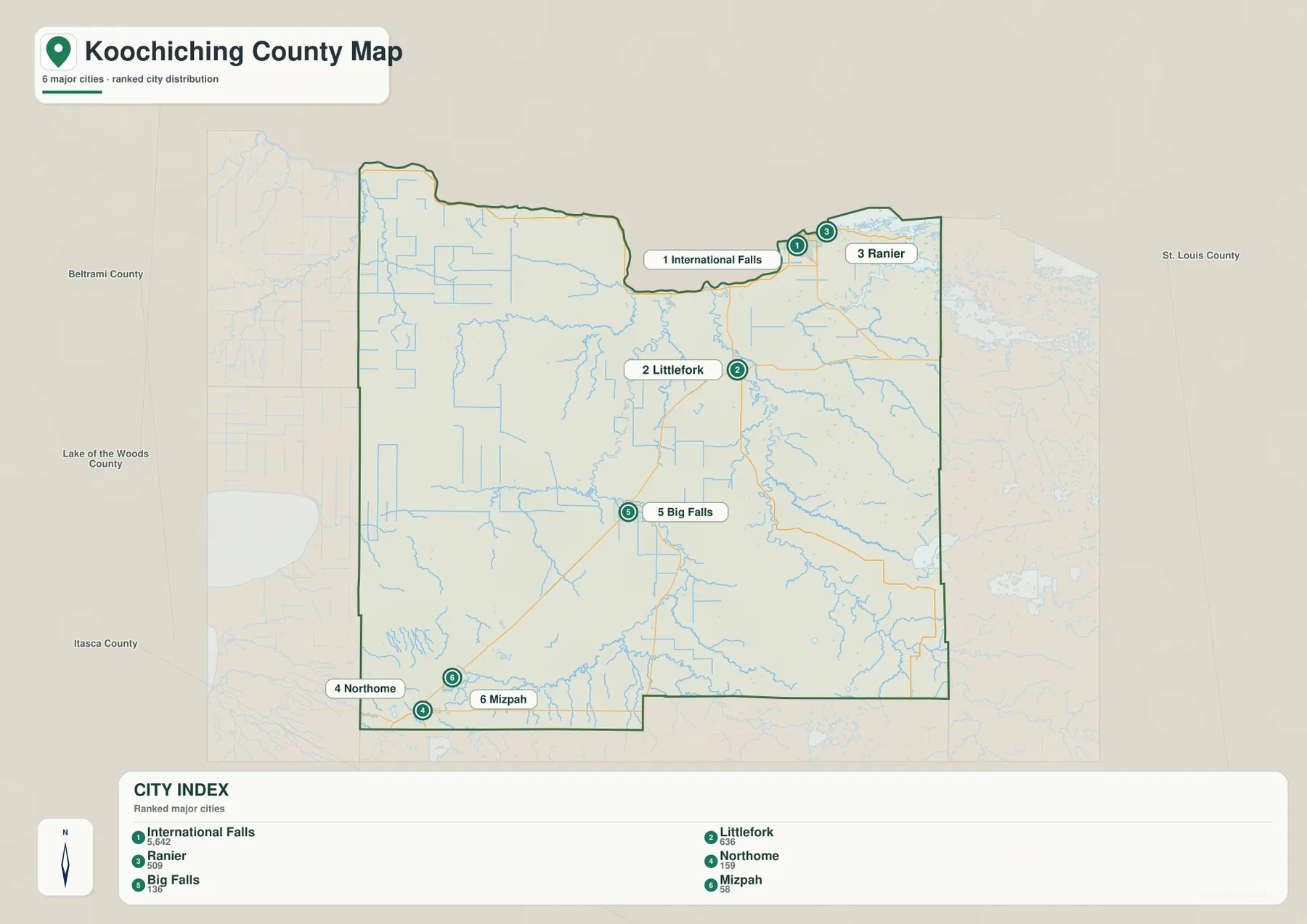
The CITY INDEX printed on the supplied map lists International Falls at 5,642, Littlefork at 636, Ranier at 509, Northome at 159, Big Falls at 136, and Mizpah at 58. These values should be treated as index figures embedded in the map rather than as claims about the latest official population estimates. Their most useful message is comparative: International Falls is represented as much larger than the other selected communities.
International Falls and Ranier function as the clearest northeastern pair, while Littlefork and Big Falls are separated inland along the river and road network. Northome and Mizpah are closer to one another than to the northern communities. Looking at the city map first and the road map second makes the county’s extreme settlement spacing much easier to understand.
Koochiching County’s official website lists the county courthouse and government offices in International Falls. That official location aligns with the map’s portrayal of International Falls as the dominant selected community and the principal administrative reference for the county.
Rainy River and the Rainy Lake side of the northeast
Rainy River is the most important water feature along the northern boundary. It runs beside Canada and connects the International Falls-Ranier area with the broader Rainy Lake system. Jackfish Bay and Black Bay are labeled in the northeastern corner, showing how large lake waters reach directly into the county’s border landscape.
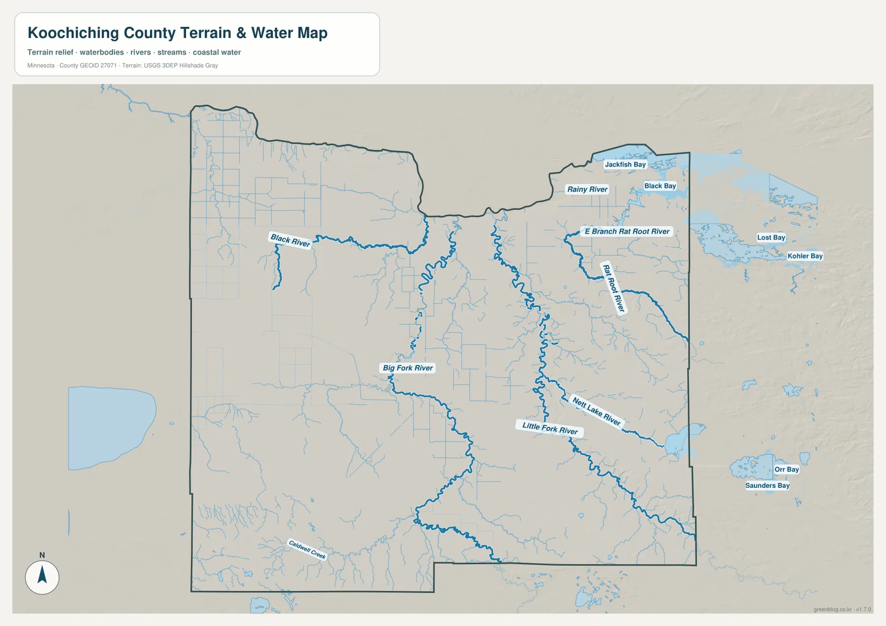
The National Park Service places Voyageurs National Park’s Rainy Lake Visitor Center on Black Bay east of International Falls. That official location fits the map closely: International Falls and Ranier sit next to a border landscape where river, lake, and bay geography matters as much as the road network.
Rainy River is more than a northern map edge. It is the receiving water for major tributaries crossing the county and a defining international boundary. The map here is intended for geographic orientation, however, not flood-hazard analysis, border procedures, navigation rules, or water-depth decisions.
Big Fork and Little Fork rivers organize the interior
Big Fork River and Little Fork River are the clearest large waterways in the county interior. Big Fork River bends north through the central-western side, while Little Fork River follows a separate winding course farther east. Both ultimately connect the southern and central county to the Rainy River system along the Canadian border.
Minnesota DNR maintains State Water Trail information for both rivers. The agency’s Little Fork River material describes a wild, difficult-to-access upper environment that becomes more developed toward Littlefork, while Big Fork River also forms a long northbound route toward Rainy River. Those official river resources are useful because much of central Koochiching County is easier to describe by waterways than by towns.
Black River is labeled on the western side, while East Branch Rat Root River and Rat Root River cross the eastern interior. Nett Lake River lies farther south and east, joining the same broader network of north-flowing waterways. The pattern is therefore not one simple trunk river; several major channels drain different parts of a very large county.
Caldwell Creek appears in the southwest, and the map contains many smaller unnamed streams and straight drainage lines. These features show how wetlands and low terrain are linked by numerous minor channels even where no major river name is printed.
A 323–461 meter contrast between northern lowlands and southern hills
The supplied elevation map reports an actual range of about 323 to 461 meters, with a mean near 371 meters. Dark green low terrain dominates the Rainy River side of the north, while yellow and brown become more common toward the south. Stronger uplands occupy both the southwest and southeast, creating a pronounced north-south elevation contrast.
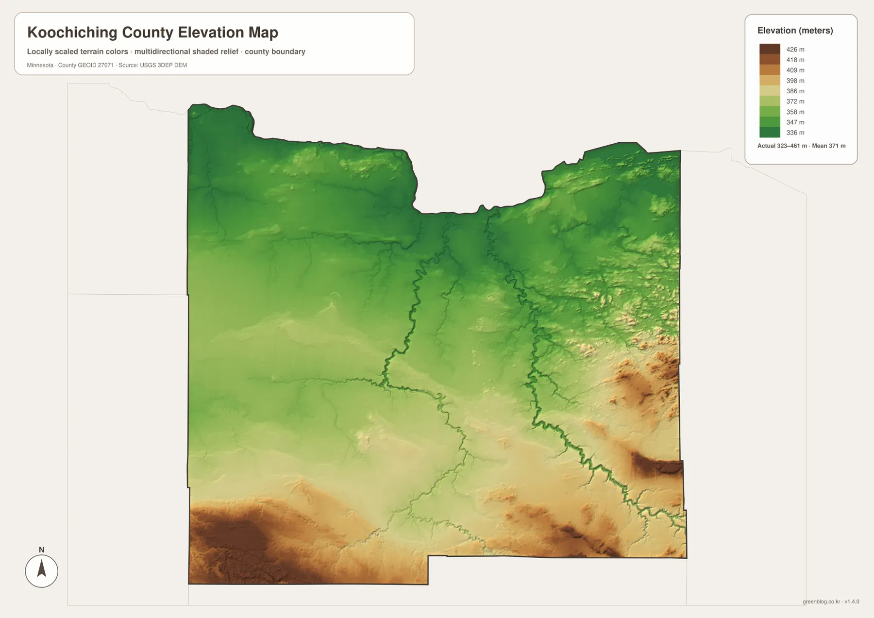
The north is broad and low rather than perfectly flat. Rainy River and its nearby tributaries occupy subtle valleys, and the International Falls area remains well below the strongest southern uplands. Small ridges appear in the northeast, but the overall northern color remains green.
Through the middle of the county, Big Fork River and Little Fork River occupy narrow lower corridors. The surrounding ground rises gradually toward the south, which helps explain why both rivers trend toward the lower northern boundary. Comparing the water and elevation views makes this relationship particularly clear.
Southwestern terrain near and south of the Northome-Mizpah area becomes substantially higher, and the southeast contains an even broader area of tan and brown relief. Smaller high patches also occur in the east-central interior. Koochiching County therefore should not be described as one flat wetland plain; its southern hills form a major part of the county’s physical geography.
This elevation surface is appropriate for county-scale comparison, not surveying or engineering. It should not be used for exact building elevations, road grades, drainage design, or parcel-level contour decisions. Detailed USGS 3D Elevation Program products or professional survey data are the better sources when precision matters.
International Falls and Northome reveal the county’s north-south contrast
International Falls combines the county’s largest selected city, the Canadian border, Rainy River, and major highways in one compact northern area. Voyageurs National Park’s Rainy Lake Visitor Center is also nearby. On the elevation map, this border city sits within a broad lowland rather than among the county’s highest hills.
Northome and Mizpah provide the opposite geographic setting. Their southwestern side lacks the huge border waters of International Falls and lies much closer to stronger uplands. Highway 71, Route 1, and Route 46 provide road references, but forests, streams, and higher terrain become more important for understanding the landscape.
Littlefork and Big Falls occupy the broad middle between those two ends of the county. Their association with Little Fork River, Big Fork River, and the central road network makes them useful transition points. They show how Koochiching County’s scattered settlements often follow rivers and long transportation corridors rather than forming one continuous urban belt.
Choosing a view for borders, towns, waterways, or relief
Use the general county map when International Falls, Littlefork, Ranier, Northome, Big Falls, Mizpah, and the major numbered roads need to appear together. The city map is cleaner when the goal is to compare the six selected communities and understand how widely they are spaced.
The water map is the stronger choice for Rainy River, Big Fork River, Little Fork River, Rat Root River, Nett Lake River, and the northeastern bays. Pair it with the elevation map when the goal is to explain the broad northern lowland and the much higher southern terrain.
For printing or image editing, the original JPG files in the ZIP provide more resolution than the WebP previews embedded in this article. Each JPG measures 3638 by 2572 pixels, and the archive contains the county, city, water, and elevation maps.
Official county, Voyageurs, DNR, and federal references
Koochiching County’s official website provides government, tax, election, and land-related services from International Falls. Parcel, permit, tax, legal-boundary, and administrative questions should rely on those current county resources rather than on a general-purpose overview map.
The National Park Service is the appropriate official source for Rainy Lake and Voyageurs National Park information, while Minnesota DNR maintains State Water Trail resources for Big Fork and Little Fork rivers. USGS National Hydrography supports water data, and the USGS 3D Elevation Program provides detailed elevation products.
Frequently Asked Questions
Why are International Falls and Ranier clustered at the northern edge?
Both communities are close to Rainy River and the Rainy Lake system along the Canadian border. International Falls is also a major highway and administrative reference, while Ranier sits just to the east near the lake side of the border landscape.
Where do Big Fork River and Little Fork River flow?
Both are major north-flowing tributaries crossing the interior of Koochiching County and ultimately connecting with the Rainy River system. Big Fork River lies farther west, while Little Fork River follows a separate course through the central-eastern interior.
Where is the highest terrain in Koochiching County?
The supplied elevation map shows a range of about 323–461 meters with a mean near 371 meters. The northern Rainy River side is lowest overall, while the strongest uplands appear in the southwest and southeast. Exact site elevations require detailed USGS or survey data.
Map File Information
Download the original high-resolution JPG versions of the Koochiching County maps shown on this page in one ZIP file.
- Included Files: county map, city map, water map, elevation map
- Printable Size: each JPG is 3638 × 2572 px
- File Type: ZIP containing 4 JPG files
Related Maps
Sources and references
- Koochiching County official website – county government and official services in International Falls
- Voyageurs National Park – Rainy Lake Visitor Center and park information near International Falls
- Minnesota DNR Little Fork River State Water Trail – official Little Fork River segment information
- Minnesota DNR Big Fork River State Water Trail – official Big Fork River trail information
- USGS National Hydrography – river, stream, and water data
- USGS 3D Elevation Program – elevation data and products
Green Map creates custom-edited map images using open geographic data sources such as geoBoundaries, Natural Earth, OpenStreetMap, and government open data. These maps are edited visual materials, not raw data files, and are provided for education, documents, presentations, and graphic reference.