Kittson County occupies Minnesota’s far northwestern corner, touching Canada on the north and the Red River of the North along the North Dakota boundary on the west. Hallock is the strongest central-western reference, Lancaster lies farther north, and Karlstad sits in the southeast. Broad lowlands near the Red River rise toward the east, while the Two Rivers system divides the interior into several branching drainage corridors.
This page uses the supplied county, city, water, and elevation maps to explain those county-specific relationships with the actual places shown in the package. Original high-resolution JPG versions are also available together in one ZIP download for printing, classroom work, presentations, or image editing.
Table of Contents
Finding Hallock between the Canadian border and the Red River
The quickest way to understand the county map is to start with its outer edges. The western boundary follows the winding Red River of the North, separating Minnesota from North Dakota, while the straight northern boundary is the international border with Canada. Hallock sits a short distance inland from the river in the central-western part of the county and provides the clearest anchor for the road network.
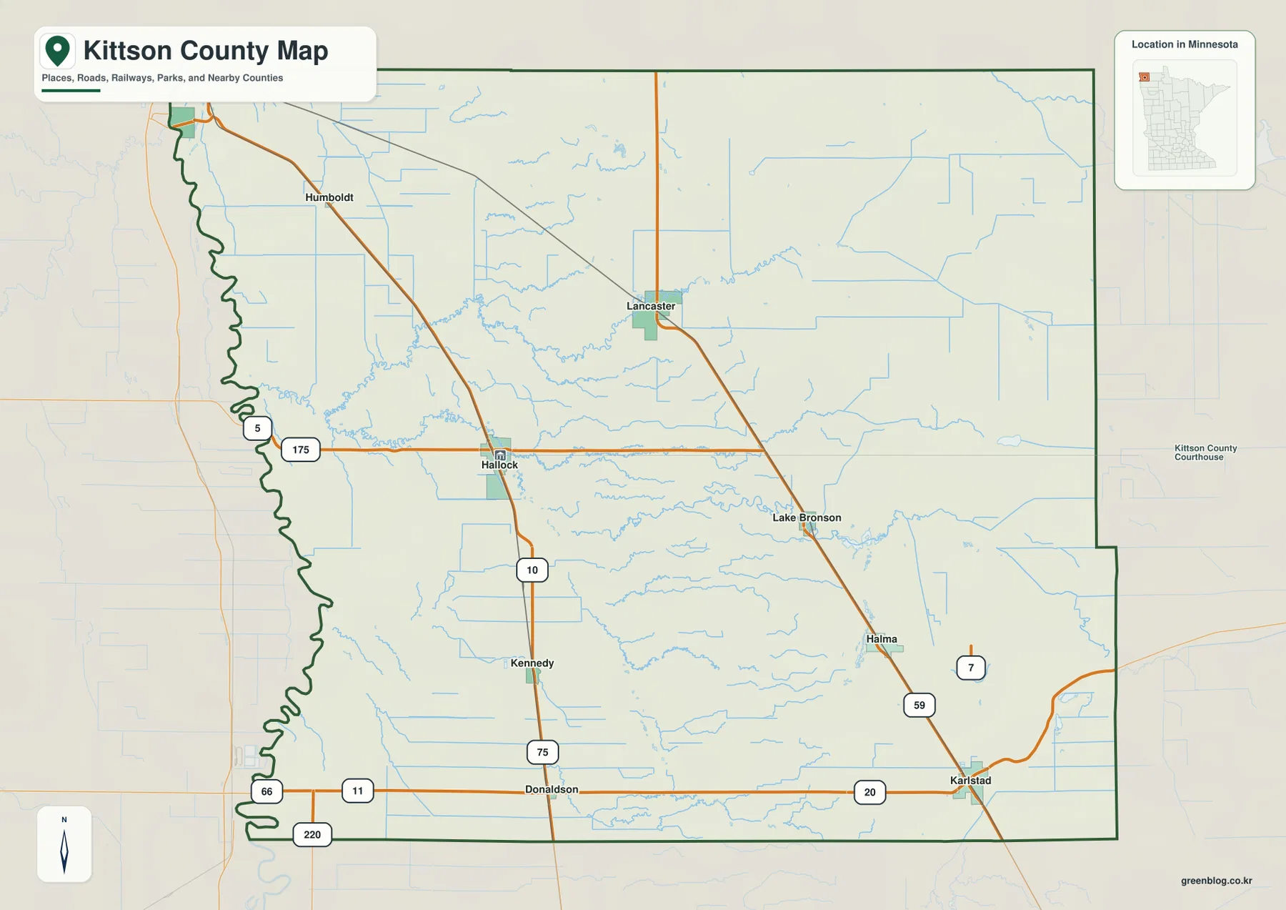
Highway 175 crosses the Hallock area from west to east, while a major north-south route continues through Kennedy and Donaldson. Route 5 is labeled near the Red River side, and Routes 11 and 220 appear close to the southern boundary. The road system covers a large rural county where towns are widely separated, so road numbers and settlement names are most useful when read together.
Lancaster is the key northern community, with Humboldt farther northwest. A major diagonal road continues southeast through Lake Bronson and Halma toward Karlstad, linking the upper county with the southeastern corner. Because the county ends at Canada, the road pattern near the north edge differs from an inland Minnesota county where roads continue into another Minnesota county.
Karlstad sits near Route 20 and a north-south highway in the southeast. Halma and Lake Bronson lie to its north, while Donaldson anchors the southwestern interior near Route 11. The general map is useful for orientation, but it does not provide live road conditions, winter closures, or border-crossing requirements, so those details should be checked with current transportation and border services.
Six small communities spread from St. Vincent to Karlstad
The city map highlights Hallock, Karlstad, Lancaster, Lake Bronson, Kennedy, and St. Vincent. Hallock occupies the central-western interior, Karlstad is in the southeast, and Lancaster is in the northern center. Lake Bronson lies between Lancaster and Karlstad, Kennedy sits south of Hallock, and St. Vincent occupies the far northwestern corner near both the Red River and Canadian boundary.
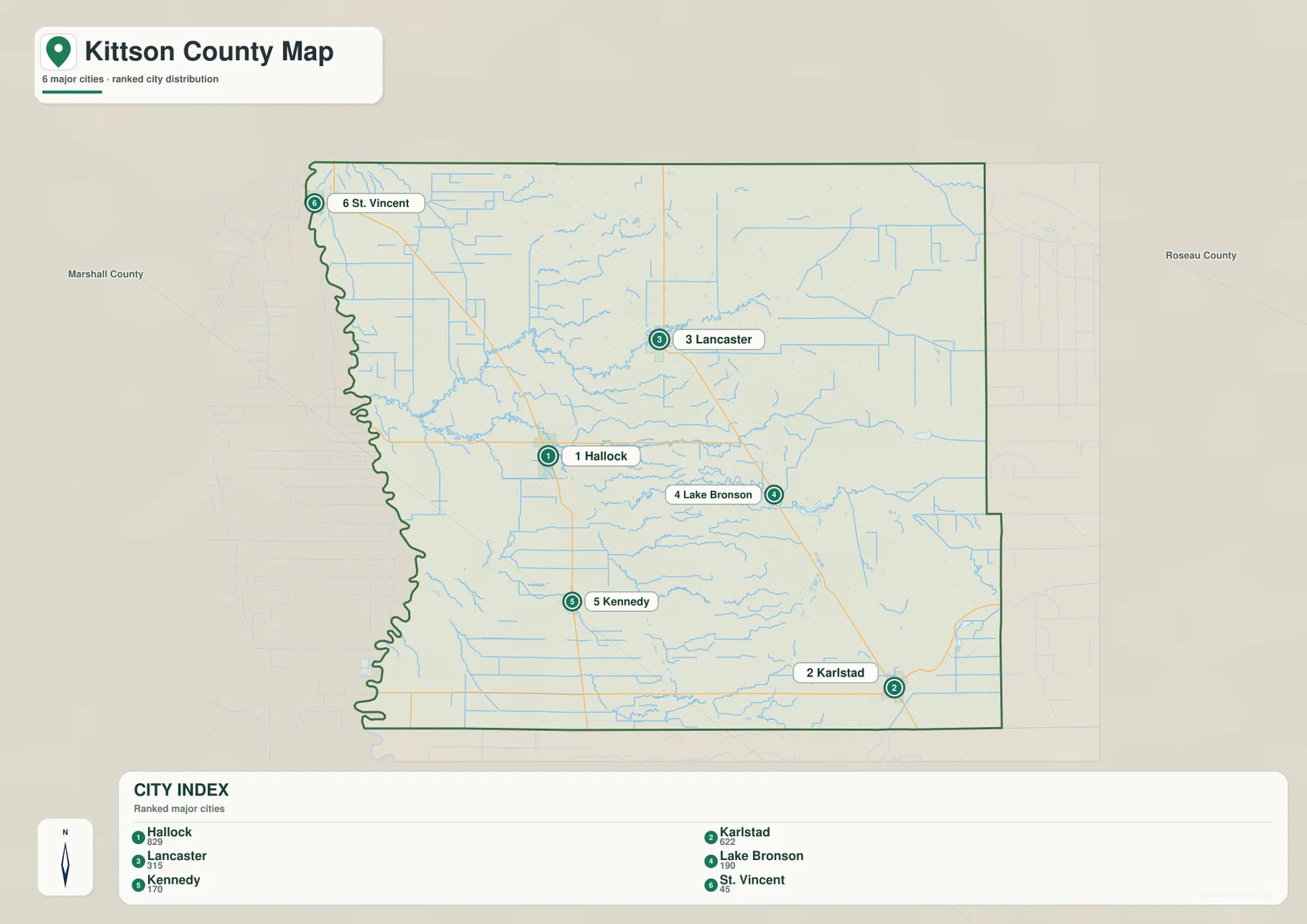
The CITY INDEX printed on the supplied map lists Hallock at 829, Karlstad at 622, Lancaster at 315, Lake Bronson at 190, Kennedy at 170, and St. Vincent at 45. These values should be treated as index figures embedded in the map rather than as claims about the latest official population estimates. Their main value is comparative: Hallock and Karlstad are shown as the two largest selected communities.
Their physical settings are also different. Hallock is close to the broad low Red River side of the county, while Karlstad is much farther east where elevation is higher. Lancaster provides a northern road and settlement reference, and St. Vincent is the clearest example of Kittson County’s border geography because it sits near the northwest corner where the international boundary approaches the Red River.
This city view is not a driving-distance map. Travel among Hallock, Lancaster, Karlstad, and the smaller communities depends on the highway chosen and local road connections. Use the city map for relative location, then return to the county map when road numbers and routes matter.
Three Two Rivers branches converge across the county interior
The most distinctive feature on the water map is the Two Rivers system. Two Rivers itself reaches the western side of the county, while North Branch Two Rivers, Middle Branch Two Rivers, and South Branch Two Rivers approach from the interior. The repeated branching pattern makes the county’s central drainage much easier to understand than it is on the road map.
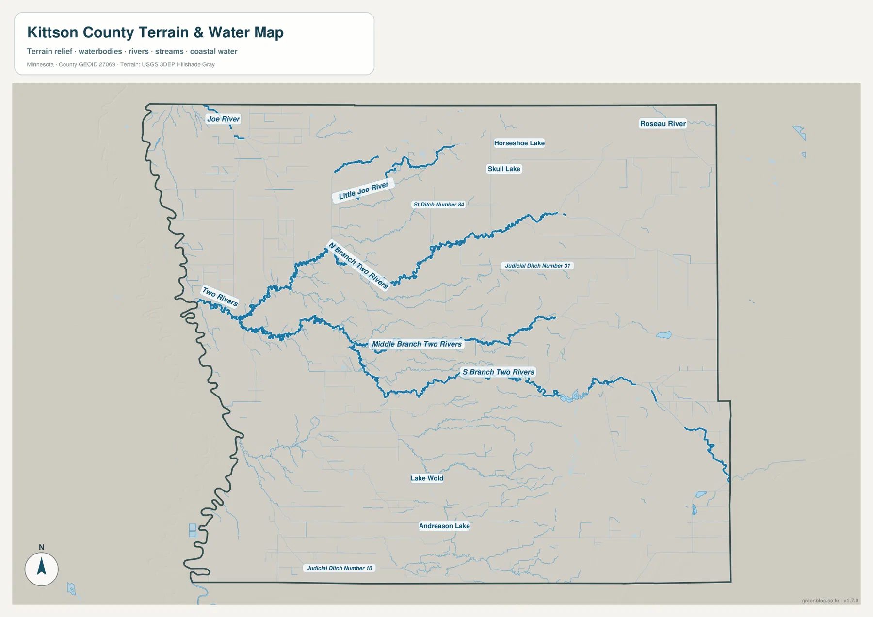
North Branch Two Rivers crosses the north-central interior toward the west, while Middle Branch Two Rivers runs through the middle of the county. South Branch Two Rivers follows a separate course farther south. The branches sometimes appear roughly parallel, but each occupies its own low corridor and should be treated as a distinct waterway.
The map also labels Judicial Ditch Number 31 and Judicial Ditch Number 10, along with S Ditch Number 84. Those straight drainage features are important in a flat agricultural county because they differ visibly from the winding natural channels. Comparing the ditches with Two Rivers helps distinguish managed drainage from natural river courses.
Little Joe River, small lakes, and the Red River edge
Little Joe River is one of the clearest named waterways in the north, and Joe River is labeled close to the northwestern side. Little Joe River winds across the upper interior with numerous smaller channels and ditches around it. Even directly below the Canadian border, the landscape is crossed by a surprisingly dense network of water features.
Horseshoe Lake and Skull Lake are labeled in the northeastern interior, while Lake Wold and Andreason Lake appear farther south. The county is not dominated by large lakes, but rivers and drainage channels are widespread. That makes the water map particularly useful for explaining the otherwise broad, open agricultural landscape.
The Red River of the North forms the county’s western edge. Minnesota DNR maintains a Red River State Water Trail and notes that the river touches two states, which means regulations can differ by side. The map on this page is a geographic reference only; it is not a flood, navigation, parcel-boundary, or water-depth product.
A 230–330 meter rise from the Red River lowland to the east
The supplied elevation map reports an actual range of about 230 to 330 meters, with a mean near 276 meters. The lowest dark-green terrain hugs the western Red River boundary, while colors shift through lighter green and yellow toward brown in the east. The southeastern and northeastern parts of the county are clearly higher than the broad western lowland.
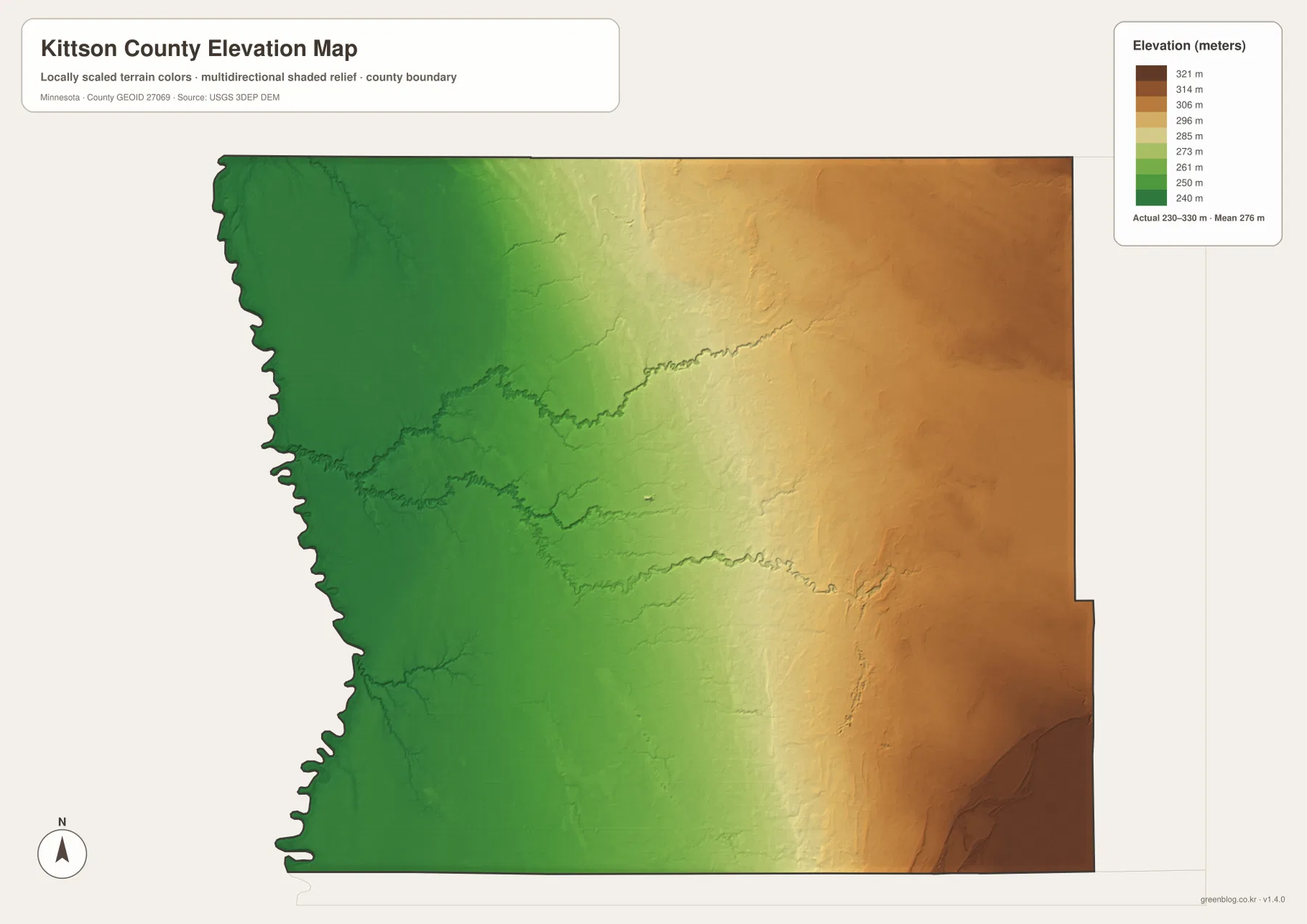
The west is remarkably flat around the Red River side, including the Hallock and St. Vincent area. Subtle drainage channels create narrow low features, but broad hills are largely absent. The river boundary itself remains visually consistent with the lowest terrain on the map.
Elevation rises gradually through the center, while the Two Rivers branches occupy slightly lower corridors within that transition. Middle Branch and South Branch Two Rivers are especially useful examples: the channels extend westward from higher ground and descend toward the Red River lowland. Water and elevation therefore tell the same geographic story from different angles.
The east contains the strongest brown high ground, especially toward the southeast. Karlstad and Halma are closer to this higher terrain than Hallock, and the northeastern interior is also elevated relative to the western border. The county broadly rises from west to east, although individual river valleys interrupt the slope.
This elevation surface is appropriate for county-scale comparison, not surveying or engineering. It should not be used for exact building elevations, road grades, drainage design, or parcel-level contour decisions. Detailed USGS 3D Elevation Program products or professional survey information are the better sources when precision matters.
Hallock and Karlstad sit in noticeably different terrain
Hallock is both a central road reference and the county’s administrative center. Minnesota’s Secretary of State lists the Kittson County election office in Hallock, matching the map’s portrayal of the community as the strongest central-western settlement. Its setting is close to the lower Red River plain and the Two Rivers system.
Karlstad lies in a different environment. The southeastern community is much closer to the county’s higher eastern terrain, and South Branch Two Rivers crosses the broader area. On the elevation map, Karlstad’s side of the county is visibly higher than Hallock’s western lowland, even though both are among the principal communities shown.
Lancaster and St. Vincent provide another useful contrast. Lancaster is inland along the northern road network, while St. Vincent sits at the far northwest near the Red River and the international border. Seeing both places together makes Kittson County’s border position much more concrete than a simple county outline would.
Choosing a map for borders, towns, rivers, or elevation
Use the general county map when Hallock, Lancaster, Karlstad, Lake Bronson, Kennedy, the main roads, the Canadian border, and the Red River edge need to appear together. The city map is cleaner when the goal is to compare the six selected communities and their map index values without all of the road detail.
The water map is the stronger choice for Two Rivers, its three branches, Little Joe River, drainage ditches, and the county’s small lakes. Pair it with the elevation map when the goal is to show why so many channels descend from higher eastern terrain toward the low Red River side.
For printing or image editing, the original JPG files in the ZIP provide more resolution than the WebP previews embedded in this article. Each JPG measures 3638 by 2572 pixels, and the archive contains the county, city, water, and elevation maps.
Official Kittson County, DNR, and federal references
Kittson County’s official website provides county government and department information from Hallock. Minnesota’s Secretary of State also lists the Kittson County election office in Hallock. Parcel, tax, permit, election, and official road questions should rely on those current government sources rather than on a general overview map.
Minnesota DNR’s Red River State Water Trail is the better source for river segments and current recreational guidance. U.S. Census Bureau TIGER/Line files support boundary and road work, USGS National Hydrography provides water data, and the USGS 3D Elevation Program provides detailed elevation products.
Frequently Asked Questions
Does Kittson County touch both Canada and North Dakota?
Yes. The northern county line is the U.S.–Canada border, while the western boundary follows the Red River of the North beside North Dakota. St. Vincent sits near the far northwestern corner where those two border features come close together.
How is the Two Rivers system divided in Kittson County?
The water map labels Two Rivers together with North Branch Two Rivers, Middle Branch Two Rivers, and South Branch Two Rivers. The branches cross the central and eastern interior and generally descend toward the lower Red River side of the county.
Where are the lowest and highest parts of Kittson County?
The supplied elevation map shows a range of about 230–330 meters with a mean near 276 meters. The Red River side in the west is lowest, while the east, especially the southeast, is higher. Exact site elevations require detailed USGS or survey data.
Map File Information
Download the original high-resolution JPG versions of the Kittson County maps shown on this page in one ZIP file.
- Included Files: county map, city map, water map, elevation map
- Printable Size: each JPG is 3638 × 2572 px
- File Type: ZIP containing 4 JPG files
Related Maps
Sources and references
- Kittson County official website – county government and department information
- Minnesota Secretary of State county election offices – official Kittson County office information in Hallock
- Minnesota DNR Red River of the North – river segments and recreation reference
- U.S. Census Bureau TIGER/Line Shapefiles – boundary, road, and place data
- USGS National Hydrography – river, stream, and water data
- USGS 3D Elevation Program – elevation data and products
Green Map creates custom-edited map images using open geographic data sources such as geoBoundaries, Natural Earth, OpenStreetMap, and government open data. These maps are edited visual materials, not raw data files, and are provided for education, documents, presentations, and graphic reference.