Penobscot County stretches from the Bangor-Brewer area in south-central Maine through Old Town, Lincoln, and Millinocket to a long northern section filled with rivers, lakes, and widely spaced roads. The Penobscot River is the easiest geographic reference for reading the county because many communities and transportation routes sit near its broad north-south course. This page compares the county road map, a simplified Bangor-centered city map, and a terrain-and-water map, and the same map set is available as high-resolution JPG files in a downloadable ZIP package.
The county changes character as the map moves north. Bangor, Brewer, Old Town, and Orono form the densest cluster of city labels and roads, while the central section around Lincoln and Mattawamkeag is more spread out. Beyond Millinocket, settlement labels become sparse and water features take a larger role in orientation. Looking at those three zones together is more useful than treating Penobscot County as simply a Bangor-area county.
Table of Contents
Bangor, Brewer, Old Town, and Orono form the southern reference area
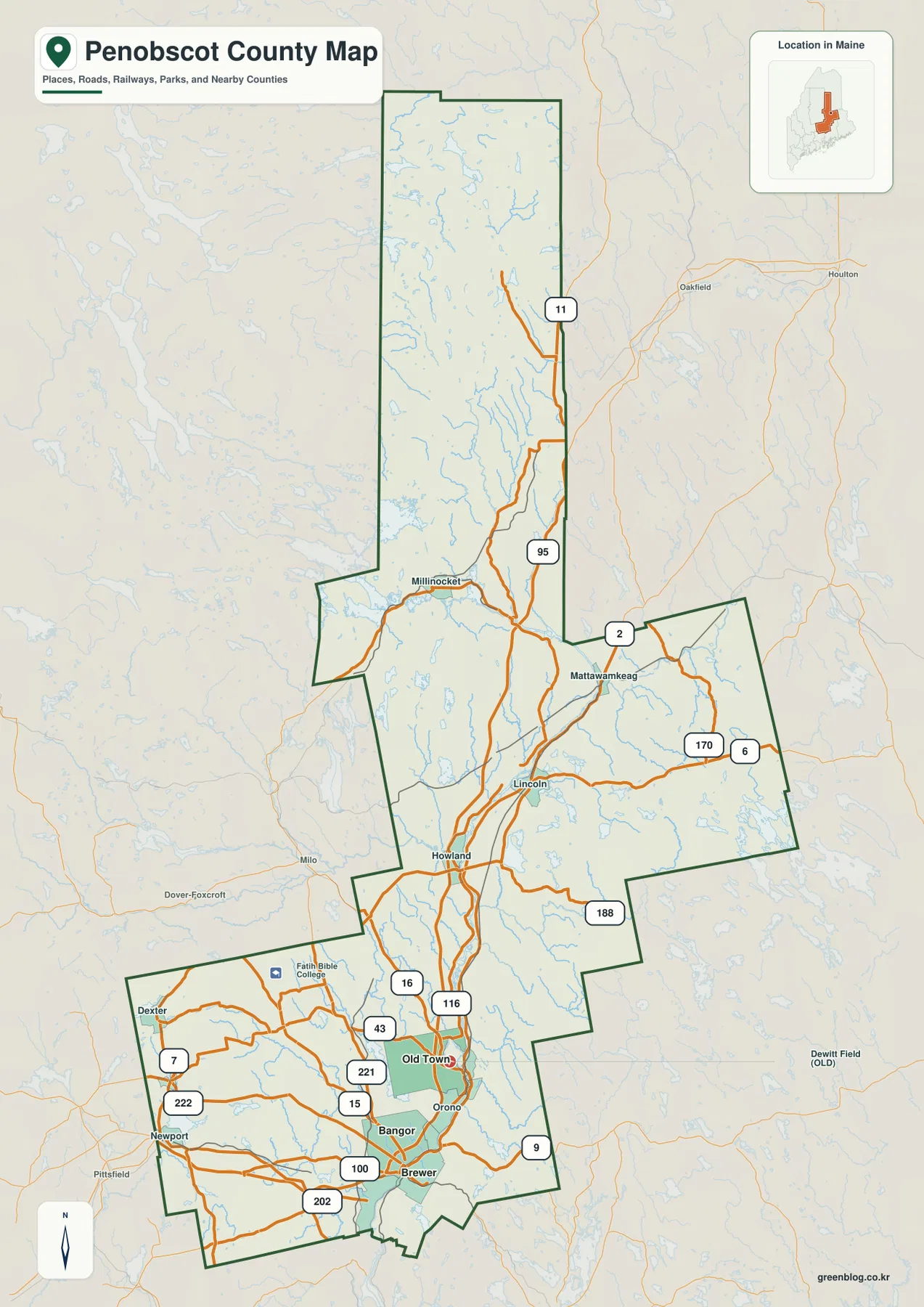
The southern part of the main county map contains the strongest concentration of roads and place names. Bangor and Brewer sit close together near the county’s southern edge, with Old Town and Orono farther north along the Penobscot River corridor. Penobscot County’s official website also lists county offices in Bangor, reinforcing the city’s usefulness as a practical reference point for both administrative and geographic orientation.
Bangor and Brewer are separated by the Penobscot River but function as neighboring map anchors. I-95, U.S. 202, Route 15, Route 9, Route 100, and several local routes are visible around the two cities. To the west and northwest, Routes 222 and 43 help connect smaller communities, while the county boundary turns sharply around the lower section. The road pattern is busy enough that it is usually easier to locate I-95 and the river first, then follow the smaller road that leads toward a specific town.
Old Town and Orono continue the populated corridor north of Bangor. Around Old Town, the map labels Routes 16, 43, 116, and 221, while Orono occupies a useful position between Old Town and Bangor. The combination of river, roads, and closely spaced communities makes this section relatively easy to read even at a small scale. By comparison, the western and eastern edges of the county contain fewer city labels and longer stretches between road junctions.
Newport appears toward the southwest edge of the county map, while the boundary around Bangor and Brewer creates a more irregular southern outline. This is a useful reminder that Penobscot County is not a simple rectangle. For a printed overview, the county boundary and the larger city labels provide enough structure; on screen, zooming in reveals the state routes and local connections that fill the gaps between those larger points.
I-95, U.S. 2, and Route 11 organize the county at different scales
I-95 is the clearest long-distance road on the map. It enters the southern part of Penobscot County near Bangor and continues north through the central portion of the county before heading toward northern Maine. Because the county is so long, the interstate provides a convenient first line for understanding how the southern city cluster relates to Lincoln, Mattawamkeag, and other communities farther north. Current travel times, exits, closures, and winter conditions should always be checked separately, but the map makes the regional direction easy to see.
U.S. 2 is more useful for east-west orientation across the central and eastern sections. Near Mattawamkeag it is shown close to Routes 6 and 170, and it connects with the broader network around Lincoln. Route 11 serves a different purpose: it continues north through the narrow upper portion of the county and remains one of the most visible roads beyond the more populated central section. The contrast between these routes illustrates why a single “main road” description does not fit the entire county.
Lincoln is a practical midpoint between the Bangor area and the far north. The map places it south of Mattawamkeag and east of Howland, near the Penobscot River system and several road connections. Millinocket sits farther north and west, close to the section where the county boundary projects westward before narrowing again. Following these two communities in sequence helps bridge the visual gap between the dense southern road network and the sparse northern map.
Other labeled routes include 6, 7, 9, 15, 16, 43, 100, 116, 170, 188, 202, 221, and 222. They matter most when the reader is looking for a particular town or cross-county connection rather than trying to memorize the whole road system. The map is an orientation resource, not a live navigation product, so road construction, seasonal restrictions, and real-time traffic need to be checked with current transportation sources before a trip.
City Connections uses Bangor as a hub for Brewer and Old Town
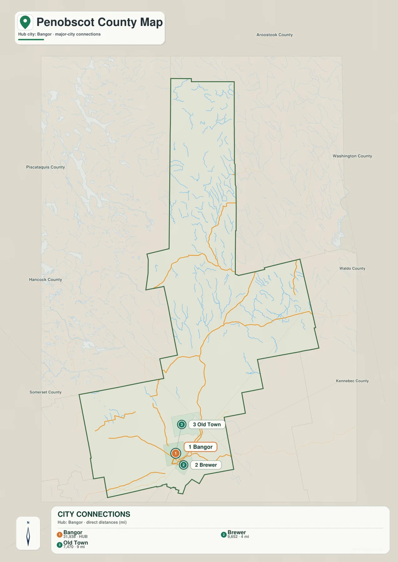
The City Connections map intentionally removes most of the local detail and focuses on three cities. Bangor is the hub, Brewer is marked 4 miles away, and Old Town is marked 9 miles away. The legend identifies these as direct distances, so they are straight-line comparisons rather than driving mileage. Road distance can be longer because a driver has to follow streets, bridges, and the available highway network.
This simplified view makes the direction of the three cities very clear. Brewer is immediately east and slightly south of Bangor, while Old Town lies to the north. That basic relationship can be harder to notice on the full road map because the southern section contains many route labels and small waterways. For classroom slides or a quick regional explanation, the city map provides a cleaner introduction before the reader returns to the more detailed county map.
The graphic also shows the values 31,938 for Bangor, 9,652 for Brewer, and 7,470 for Old Town. The image by itself does not establish the reference year or statistical definition behind those numbers, so they should not be presented as current population totals. Anyone who needs up-to-date demographic data should consult the latest U.S. Census Bureau release. The more reliable purpose of this graphic is to show relative location and direct distance from Bangor.
County names surrounding the map include Aroostook, Washington, Waldo, Kennebec, Somerset, Hancock, and Piscataquis. Those labels give useful context for Penobscot County’s position within Maine and help explain the long northern outline. They also make it obvious that Bangor is not near the geographic center of the county; it is a southern hub for a county that extends a considerable distance north.
The Penobscot River ties together several major tributaries
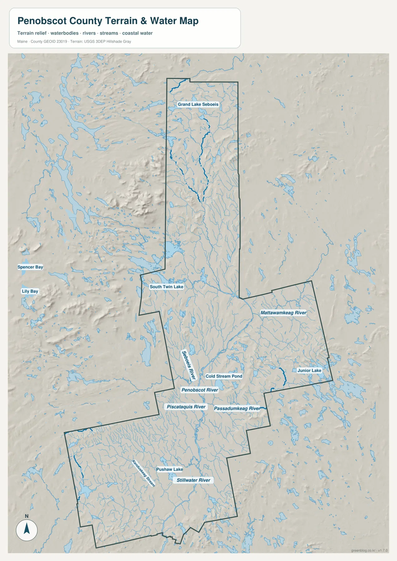
The terrain-and-water map makes the Penobscot River the dominant feature of the central and southern county. Several tributaries approach it from different directions, creating a branching network that is much easier to see here than on the road map. The Piscataquis River joins the broader system from the west, while the Passadumkeag River enters from the east. These confluences are useful orientation points because they sit near the central road-and-community corridor.
The Seboeis River appears farther north, and the Mattawamkeag River stretches across the eastern part of the county. In the southern section, Stillwater River and Kenduskeag Stream provide additional references around the Bangor-Old Town area. Switching between the road map and the water map shows how communities and roads are often close to the same river corridor without implying that every road follows the river exactly.
It is helpful to start with the Penobscot River and then trace one tributary at a time. The network is too extensive to absorb as a single set of labels, especially in the central part of the county where many streams overlap visually. A reader interested in the eastern section can follow the Mattawamkeag and Passadumkeag rivers, while someone focused on the west-central area can use the Piscataquis and Seboeis rivers as references.
Grand Lake Seboeis, South Twin Lake, and Pushaw Lake mark very different parts of the county
Grand Lake Seboeis stands out in the long northern section of the map. Around and south of it, numerous smaller streams and lakes fill the background even where very few road or city labels appear. South Twin Lake is farther southwest near the Millinocket area and the county’s western projection. These water bodies provide stronger orientation points in the north than the city pattern that dominates the Bangor area.
Junior Lake is labeled in the east-central portion of Penobscot County, while Cold Stream Pond lies closer to the central Penobscot River corridor. Farther south, Pushaw Lake appears west of the Bangor-Old Town area. The wide spacing between these lakes demonstrates that the county’s water features are not concentrated in a single district. They stretch from the populated south through the central river system to the remote northern section.
Relief shading on the water map gives a broad impression of hills and valleys. More textured terrain is visible around parts of the northern and western edges, while the major river valleys form gentler-looking corridors through the interior. This shading is intended for visual reference rather than engineering measurement. Exact elevations, slopes, and survey-grade terrain data should be obtained from authoritative elevation products such as the USGS 3D Elevation Program.
The water map is also not a flood-risk, depth, navigation, water-quality, or legal-boundary product. It is useful for comparing the general location of the Penobscot River, Mattawamkeag River, Grand Lake Seboeis, South Twin Lake, Junior Lake, Cold Stream Pond, and Pushaw Lake. Flood safety, water levels, boating conditions, and regulatory questions require the current information issued for those specific purposes.
Why the whole county looks different from the Bangor-area map
If the reader looks only at Bangor, Brewer, and Old Town, Penobscot County can seem like a compact river-centered urban area. The full boundary tells a different story. The county continues north through Lincoln and Millinocket and then narrows into a long section where lakes, streams, and a few major roads become more prominent than city labels. That contrast is one of the most important things to retain when using the map for regional context.
A useful learning sequence is to begin with Bangor, Brewer, and Old Town, then follow the Penobscot River north toward Lincoln and the Millinocket area. After those anchor points are familiar, the northern lakes and rivers are much easier to place. This method avoids treating the remote northern section as empty space and shows how the road map and water map describe different aspects of the same long county.
The maps also suit different presentation needs. The full county map works well when roads and named communities matter, the City Connections graphic is cleaner for explaining Bangor’s relationship to Brewer and Old Town, and the terrain-and-water map is better for river and lake discussions. Using each map for the information it displays best produces a clearer result than trying to force every label into one image.
Downloading and using the map files
The WebP images embedded in the article are optimized for on-page viewing. The download ZIP contains the corresponding three high-resolution JPG files, each measuring 2572 × 3638 pixels. They can be useful for printed handouts, classroom material, presentations, regional comparison, or personal reference. For legal boundary work, surveying, emergency navigation, or official road decisions, use current government datasets rather than treating these blog images as final authority.
The county road map is the best starting point for cities, numbered routes, and county shape. The City Connections map is simpler and better suited to a quick Bangor-centered explanation, while the terrain-and-water map provides the strongest view of rivers, tributaries, lakes, and general relief. Keeping all three files together makes it easy to choose the amount of detail needed for a specific project.
Frequently Asked Questions
How far is Brewer from Bangor on the City Connections map?
The map labels Brewer as 4 miles from Bangor, but that number is a direct or straight-line distance. It is not driving mileage, and an actual trip can be longer depending on the starting point, bridge, and road used. The label is best used to understand how close the two cities are to each other.
Where is Old Town in relation to Bangor?
Old Town is north of Bangor and is labeled 9 miles away on the City Connections graphic. Orono lies between the two areas on the more detailed county map, and the Penobscot River and several roads continue in the same general direction. The 9-mile value is a direct distance rather than a driving route.
Can the terrain and water map be used for flood risk or exact elevation?
No. It is a general reference for the position of rivers, lakes, streams, and terrain relief. It does not provide flood zones, water depth, live water levels, legal water boundaries, or survey-grade elevations. Use the appropriate USGS, FEMA, Maine, or local agency source when a safety, engineering, or regulatory decision depends on precise data.
Map File Information
Download the three high-resolution JPG maps described on this Penobscot County page in one ZIP file.
- Included Files: county and major-road map, City Connections map, terrain and water map
- Printable Size: 2572 × 3638 pixels each
- File Type: JPG
Related Maps
Sources and References
- Penobscot County, Maine – Official County Website
- Maine Office of the State Auditor – County Websites
- U.S. Census Bureau – TIGER/Line Shapefiles
- USGS – National Hydrography
- USGS – 3D Elevation Program
Green Map creates custom-edited map images using open geographic data sources such as geoBoundaries, Natural Earth, OpenStreetMap, and government open data. These maps are edited visual materials, not raw data files, and are provided for education, documents, presentations, and graphic reference.