Knox County occupies a distinctive piece of Maine’s mid-coast, combining the mainland communities around Rockland, Camden, and Thomaston with a broad group of islands in Penobscot Bay. The mainland looks fairly compact when the roads are viewed by themselves, but the county boundary extends well offshore, so a complete reading of the area has to include both land and water. This page compares the county-and-road map, a simplified Rockland city index, and a terrain-and-water map. The same subjects are also available as high-resolution JPG files in a downloadable ZIP package.
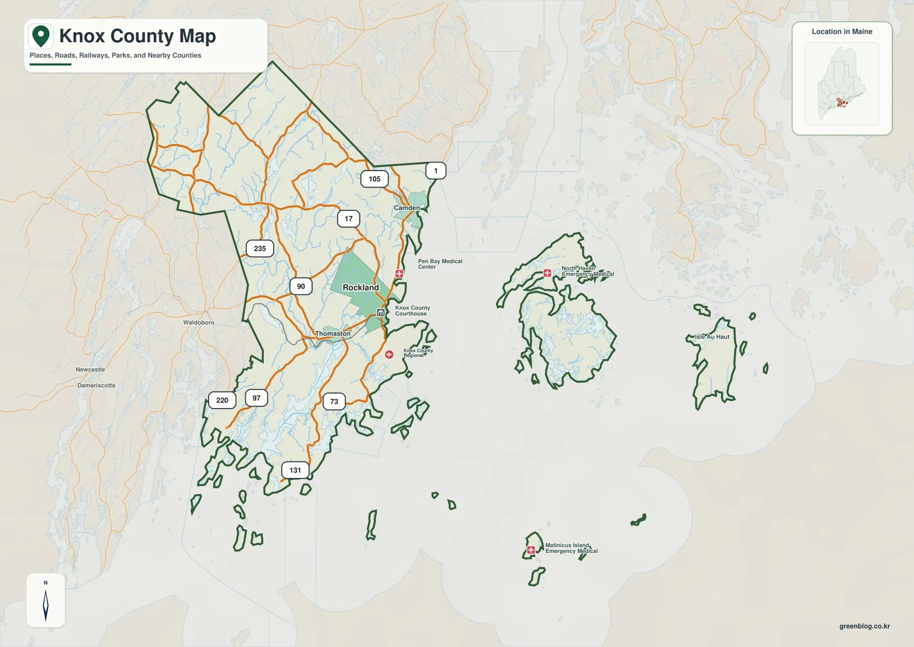
A practical way to orient the map is to find Rockland and U.S. Route 1 first. Route 1 links the coast through Camden, Rockland, and Thomaston, while Routes 17, 90, 105, and 235 extend toward the interior. Farther south, Routes 73, 131, 97, and 220 help organize the more irregular coastline. Offshore, the boundary encloses large islands and smaller outlying islands that are not connected to the mainland road network. That combination of coastal roads, river mouths, bays, and islands is the defining geographic feature of the county.
Table of Contents
Rockland, Camden, and Thomaston on the coastal road map
Rockland is the most prominent labeled community on the general county map. Several roads converge near the city, and its location on the eastern mainland coast makes it an easy reference point for the rest of Knox County. Camden lies to the north along U.S. 1, while Thomaston is southwest of Rockland. Following those three names in sequence gives a quick picture of the county’s best-known mainland coastal corridor without requiring the reader to trace every smaller local road.
Camden sits where the shoreline and higher ground come close together. U.S. 1 follows the coast through the area, and Route 105 turns inland from the Camden side of the map. The Maine Bureau of Parks and Lands describes Camden Hills State Park as being just north of Camden and notes the view from Mount Battie toward Camden Harbor and Penobscot Bay. That official description provides useful context for the shaded relief visible behind the road network: the Camden area is not simply a flat strip of shoreline.
Thomaston provides another useful anchor south and west of Rockland. As the map continues south, the mainland narrows into peninsulas and inlets, and Routes 73 and 131 extend toward that more broken coast. Straight-line separation on a small map can therefore be misleading. A destination that looks nearby may require a longer road route because bays, river mouths, and narrow peninsulas interrupt the direct path. The map is useful for orientation, but current navigation data should be used for an actual driving plan.
On the inland side, Route 17 is one of the clearest lines extending west from the Rockland area. Route 90 runs through the interior between the Rockland-Camden coast and the western side, while Route 235 connects another section of the inland network. Route 105 reaches northwest from the Camden area, and Routes 220 and 97 appear near the southwestern edge. These roads make more sense when treated as branches from the coastal reference points rather than as a list of unrelated route numbers.
The county boundary also includes substantial offshore territory. The general map shows two large island groups east of the mainland as well as smaller islands farther south and east. They are drawn within the same Knox County boundary system but do not share the mainland road grid. For regional study, this matters: Knox County cannot be reduced to the Rockland-Camden-Thomaston mainland corridor, even though that corridor contains the most obvious concentration of roads and labels.
Using U.S. 1 and Route 17 as the main mainland references
U.S. 1 is the easiest road to use as a first reference because it connects several of the county’s most visible mainland communities. On the map it comes through Camden, continues toward Rockland, and then reaches the Thomaston area. Once that line is located, smaller routes can be understood by the direction in which they leave the coastal corridor. This is more useful than trying to memorize every route number at once, especially in a county where the shoreline makes the road geometry more complicated.
Route 17 provides the strongest westward connection from the Rockland side of the map. Route 90 crosses the interior, and Route 235 serves another north-south link farther inland. North of those routes, 105 extends from the Camden area, while the southwestern side shows 220 and 97. The southern peninsula roads, including 73 and 131, turn toward narrow coastal sections where bays and river mouths create detours. Comparing the road map with the terrain-and-water map helps explain why these roads bend or separate.
The road map is not a live traffic product. It does not report closures, construction, ferry schedules, seasonal restrictions, or travel times. Its value is geographic rather than operational: it shows where the principal roads sit in relation to communities, county boundaries, and the coast. For a visitor, classroom exercise, or printed regional reference, that is enough to establish the structure of the mainland before switching to a navigation service for a specific trip.
Why the City Index highlights only Rockland
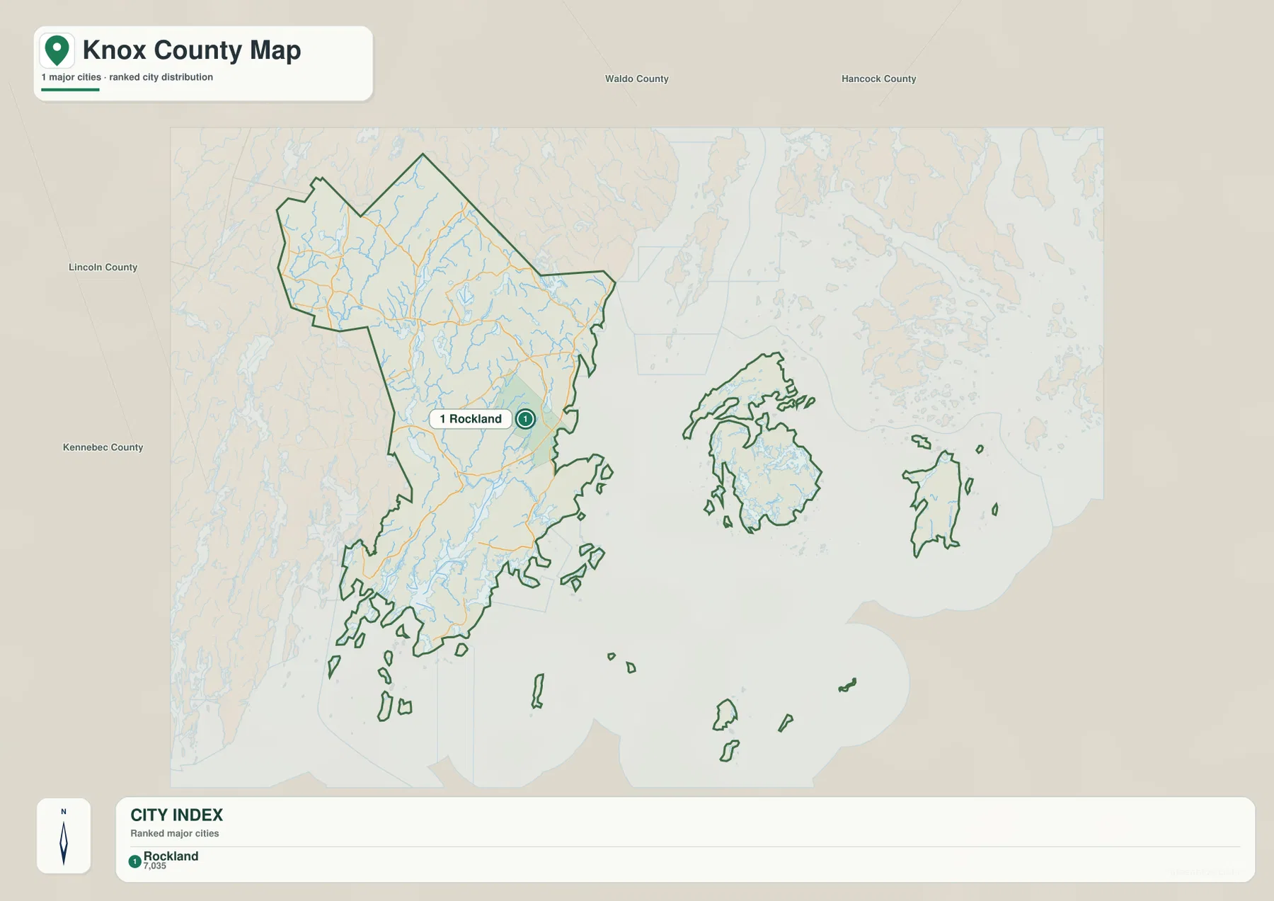
The City Index is intentionally much simpler than the general county map. In the supplied image, only one major city is ranked: Rockland. That does not mean Camden, Thomaston, or the county’s other communities are absent from Knox County. They are visible on the general map, but the city-index layer uses a narrower classification and therefore places only Rockland in its ranked list. The safest use of this graphic is to treat it as a simplified location index rather than a complete settlement map.
Rockland appears on the eastern mainland close to the coast, roughly where the denser group of roads also appears on the full map. Around the county, the City Index labels neighboring areas including Waldo County, Hancock County, Lincoln County, and Kennebec County. With most secondary labels removed, the image becomes useful for quickly showing where Rockland sits within Knox County and how the county relates to the surrounding part of mid-coast Maine.
A small number is printed beside Rockland in the supplied City Index. This article does not treat that value as a current population statistic because the image alone does not establish the statistical year or exact definition behind the figure. Current demographic information should be checked separately through the U.S. Census Bureau or another up-to-date official source. The dependable information in this graphic is the city’s relative placement, not the freshness of the numeric label.
St. George River, smaller coastal rivers, and Penobscot Bay
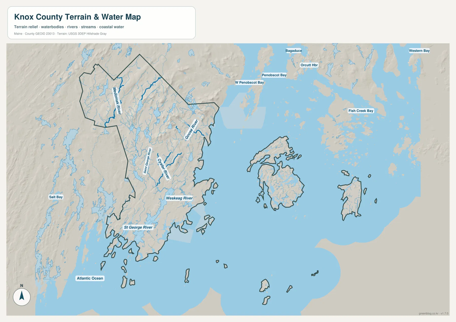
The terrain-and-water map changes the emphasis dramatically. Roads fade into the background while rivers, bays, and the offshore county boundary become the dominant features. The St. George River is one of the clearest waterways in the southwest, entering a coastline that is already broken into long inlets and narrow points. Closer to the Rockland-Thomaston area, the Oyster River and Weskeag River are labeled, while the Goose River appears farther northeast.
The Medomak River is labeled near the western side of the regional map, much of it outside or near the Knox County boundary. That makes it useful as a neighboring reference rather than as the single defining river of Knox County. The St. George River, Oyster River, Weskeag River, and Goose River have a more direct role in understanding the county’s mainland coast. Their positions help explain why the shoreline contains so many coves, estuaries, and narrow land sections instead of forming one smooth line.
Offshore, West Penobscot Bay and Penobscot Bay occupy much of the map. Other surrounding labels include Orcutt Harbor and Bagaduce to the north and northeast, Fish Creek Bay farther east, and Western Bay beyond the county islands. Some of those labels refer to waters outside the county itself, which is useful rather than confusing when the purpose is regional orientation. They show how Knox County’s islands sit within a larger bay system instead of appearing as isolated shapes on a blank ocean.
The large islands are easier to understand in this version because the water separating them from the mainland is visually emphasized. Smaller islands are also visible between and south of the larger landforms. The road map confirms the political boundary, but the water map better communicates the actual physical separation. That distinction is important for any reader who is unfamiliar with coastal Maine and might otherwise assume that every part of the county is connected by ordinary roads.
Shaded relief adds broad topographic context. The Camden and inland areas show more pronounced terrain than many of the low coastal margins, while river valleys and shoreline areas generally read as lower passages through the relief. The shading should not be interpreted as survey-grade elevation information. It is a visual aid for comparing broad landform differences. Exact elevations, engineering slopes, or site-specific measurements require a dedicated source such as the USGS 3D Elevation Program.
The water layer also has firm limits. It is not a nautical chart, flood map, tide forecast, water-quality map, or legal description of shoreline boundaries. It does not provide depths, navigation hazards, ferry routes, or current river conditions. Those uses require current specialist information from agencies such as NOAA, FEMA, USGS, or Maine authorities. Here the layer is intended to show the relative location of rivers, bays, mainland shore, and islands.
A useful reading sequence from Camden to the offshore islands
For a first pass, start with Camden at the northern end of the visible coastal corridor, follow U.S. 1 south toward Rockland, and continue toward Thomaston. Then locate Route 17 to see how the mainland network reaches west. This establishes the main road-and-community framework before the coastline becomes more complex. From there, move to the water map and find the St. George River, Oyster River, and Penobscot Bay.
After those reference points are clear, the offshore part of the county is easier to interpret. The large islands and smaller surrounding islands are separated from the mainland by substantial water, yet they remain part of the county boundary. The result is a county whose political geography is much broader than its mainland road footprint. This is why a map focused only on highways would provide an incomplete picture of Knox County.
Maine’s Department of Agriculture, Conservation and Forestry places Rockland and Camden within the state’s mid-coast travel region and describes a Route 1 drive continuing through Rockland to Camden. The same department’s Camden Hills State Park page notes the park’s proximity to Camden and the view toward Penobscot Bay from Mount Battie. These official references support the close relationship among the coast, Route 1, Camden, and the bay that is visible in the maps.
Which Knox County map works best for each task?
Use the general county map when the main need is roads, community names, and the county boundary. Rockland, Camden, and Thomaston provide good starting points, U.S. 1 organizes the coast, and Route 17 organizes a major inland direction. The same image also keeps the offshore county islands visible, making it suitable for a classroom handout or regional reference where political geography matters as much as transportation.
The City Index works best when the question is simply where the primary ranked city sits. Because only Rockland is highlighted, the graphic is cleaner than the full road map and can fit well in a presentation or brief regional overview. Its numeric label should not be reused as a current population figure unless the original statistical source and date are separately verified.
Choose the terrain-and-water map when rivers, bays, the coastline, and islands matter most. The St. George River, Oyster River, Weskeag River, Goose River, and Penobscot Bay are much easier to compare there than on the road-focused version. The shaded relief also adds useful physical context, although it remains a generalized visual reference rather than a technical elevation product.
The WebP images embedded in this page are optimized for convenient online viewing. The download package contains matching high-resolution JPG maps at 3638 × 2572 pixels each, providing more detail for printing, offline reference, classroom use, and presentations. These maps are not substitutes for cadastral surveys, legal boundary records, engineering measurements, flood determinations, or nautical navigation products.
Frequently Asked Questions
How are Rockland and Camden connected on the Knox County maps?
Both communities lie on the county’s eastern mainland coast, with Camden north of Rockland. U.S. Route 1 provides the clearest road reference between them, while Route 105 and other local routes extend inland from the Camden side. For actual driving mileage and travel time, use a current navigation service rather than estimating from the map.
Why does the City Index show only Rockland?
The supplied City Index uses a narrow major-city ranking and includes only Rockland. It should not be read as a complete list of Knox County communities. Camden and Thomaston, for example, are clearly labeled on the general county map and remain important geographic reference points even though they are not included in the ranked city layer.
Can the terrain and water map be used for boating or flood decisions?
No. The map is a general geographic reference showing rivers, bays, coastlines, islands, and broad relief. It does not provide water depth, tides, navigation hazards, flood zones, legal shoreline boundaries, or real-time conditions. Use current NOAA, FEMA, USGS, Maine state, or other specialist sources for those purposes.
Map File Information
The ZIP package contains the high-resolution Knox County JPG maps described on this page.
- Included Files: county and road map, City Index map, terrain and water map
- Printable Size: 3638 × 2572 pixels each
- File Type: JPG
Related Maps
Sources and References
- Knox County, Maine – Official County Website
- Maine DACF – Camden Hills State Park
- Maine DACF – Mid-Coast Travel Reference
- U.S. Census Bureau – TIGER/Line Shapefiles
- USGS – National Hydrography
- USGS – 3D Elevation Program
Green Map creates custom-edited map images using open geographic data sources such as geoBoundaries, Natural Earth, OpenStreetMap, and government open data. These maps are edited visual materials, not raw data files, and are provided for education, documents, presentations, and graphic reference.