Rawlins County occupies the far northwestern part of Kansas, where Atwood serves as the main road and service center for a sparse High Plains landscape. US 36 crosses the county from west to east, and K-25 meets it at Atwood before continuing toward Nebraska and the counties to the south. McDonald lies along the western US 36 corridor, while Herndon and Ludell belong to the northeastern side of the county. High-resolution map files are available for download in the section below.
The physical geography is just as important as the roads. Beaver Creek and its forks cross the middle of the county, while several branches of Sappa Creek form separate southern valleys. Elevation ranges from about 803 to 1,045 meters. WebP previews are available in the article, and the matching high-resolution JPG files can be downloaded together in one ZIP for printing, classroom work, or offline reference.
Table of Contents
Atwood sits at the county’s key US 36 and K-25 crossroads
Atwood is slightly north of the county center and provides the clearest orientation point on the road map. US 36 runs through the city from west to east, while K-25 crosses it on a north–south line. Kansas Department of Transportation projects in Rawlins County use the US 36–K-25 junction at Atwood as a major route reference, confirming the importance of the crossroads.
Westbound US 36 leads toward McDonald and the Cheyenne County side, while the highway continues east from Atwood toward the northeastern communities and Decatur County. K-25 runs from the Thomas County line south of Atwood to the Nebraska border north of town. The Kansas Historical Society identifies Atwood as the Rawlins County seat, so the administrative and transportation centers occupy the same place.
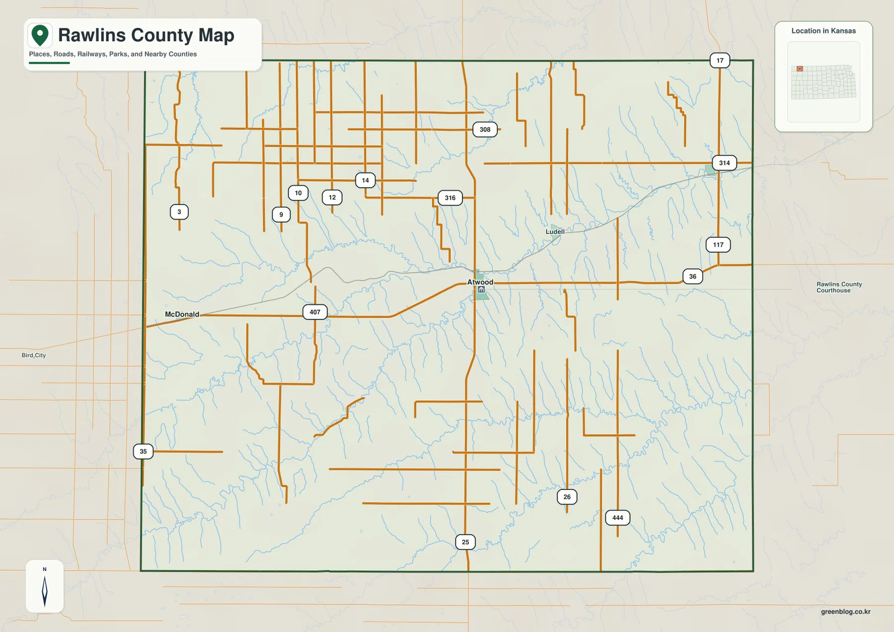
County Road 407 appears on US 36 west of Atwood. KDOT’s 2026 US 36 resurfacing project extends from near that road to the K-25 junction, making this stretch a useful real-world reference for the western approach into Atwood.
Atwood is the hub, with Herndon and McDonald on different sides of the county
The city-connections panel marks Atwood as the hub with an index value of 1,320. Herndon is listed at 159 and about 15 direct miles away, while McDonald is 249 and roughly 18 direct miles from Atwood. These are map index values rather than current official population estimates, and the mileages are straight-line measurements rather than driving distances.
The two connections occupy different settings. McDonald lies west of Atwood along the US 36 corridor, while Herndon is near the northeastern edge in a much more creek-cut landscape. Ludell also appears in the northeast. Rawlins County’s local development organization identifies Atwood, Herndon, McDonald, and Ludell as the county’s four communities.
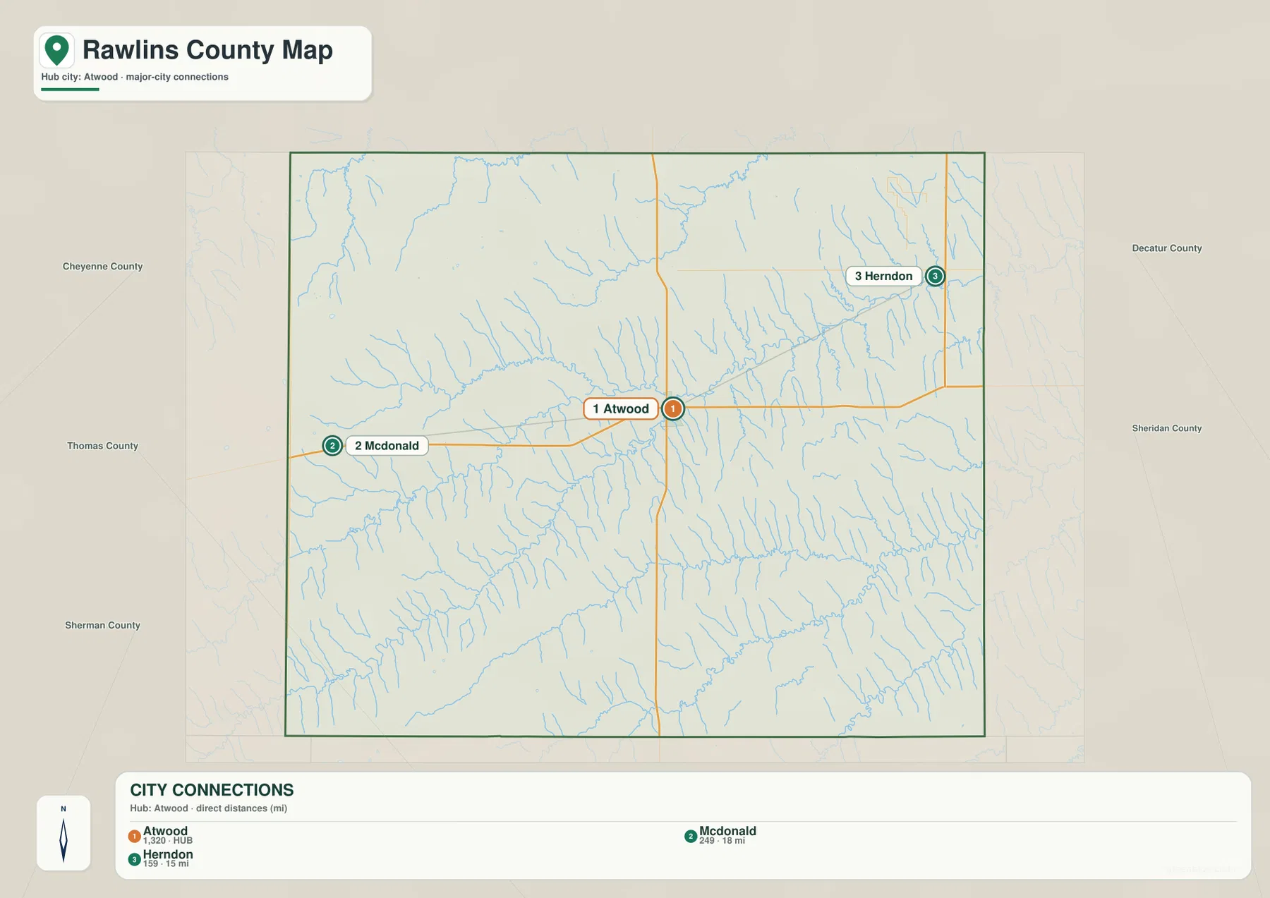
Because Herndon and McDonald are separated from Atwood in different directions, direct mileage alone does not describe their access equally. McDonald follows the main US 36 corridor, while travel toward Herndon uses smaller roads through a denser network of stream valleys.
Beaver Creek and its forks shape the broad central lowlands
The strongest central drainage on the terrain-and-water map is Beaver Creek. North Fork Beaver Creek and Middle Fork Beaver Creek descend from the western uplands, while South Fork Beaver Creek approaches from the southwest. The channels converge into a broader central valley that continues eastward.
Northern Rawlins County is cut by a separate Driftwood Creek system. North Fork Driftwood Creek and South Fork Driftwood Creek carve long valleys across the high northwestern terrain before continuing toward the east. Numerous short tributaries branch into these channels, giving the northern county much more relief than a plain road map suggests.
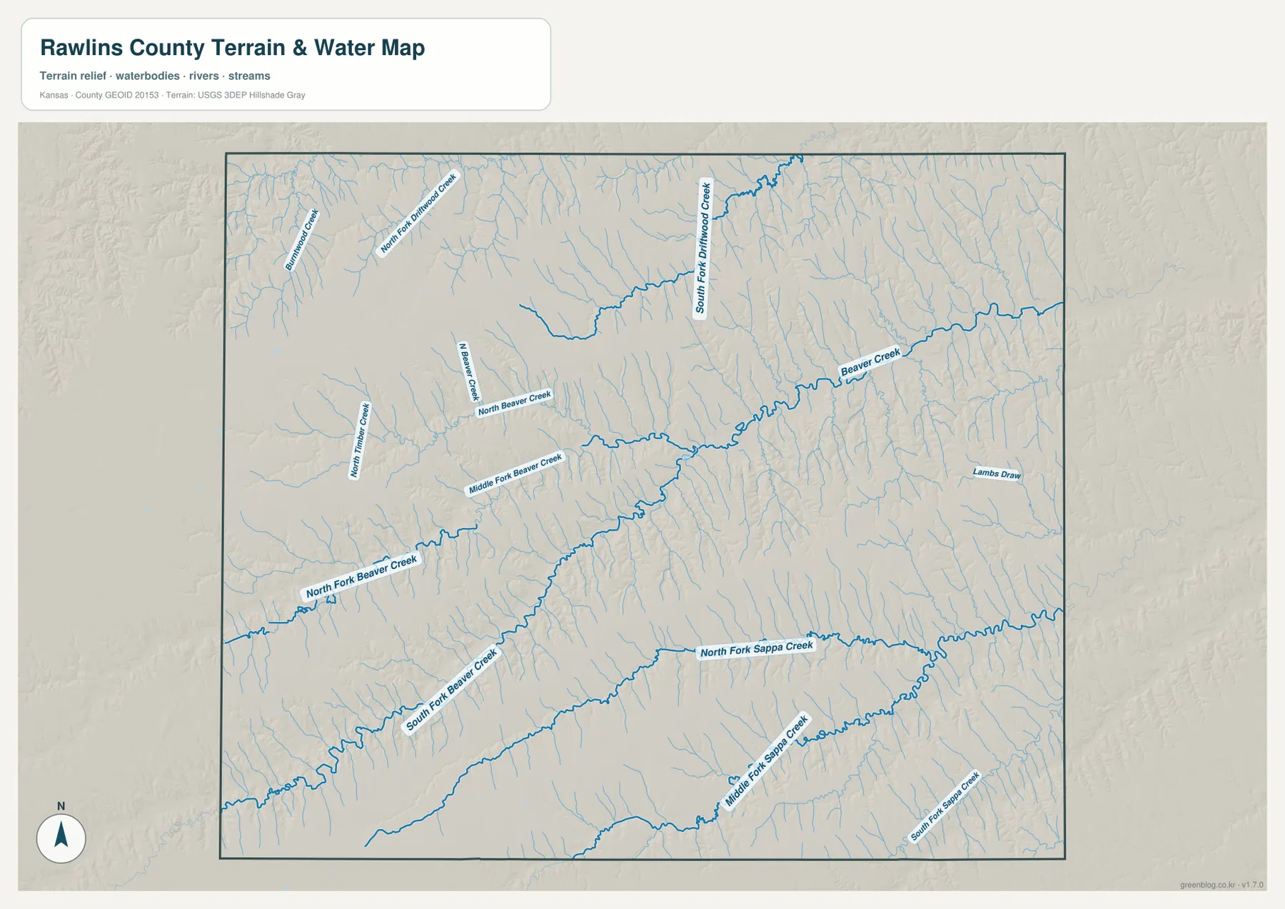
The southern half of the county is organized around the Sappa Creek system. North Fork Sappa Creek crosses the south-central area, while Middle Fork and South Fork Sappa Creek form separate long valleys farther south. Higher ground remains between the Beaver and Sappa systems, so they appear as distinct low corridors rather than one continuous basin.
This water image is intended for geographic reference rather than floodplain, navigation, water-quality, parcel, or legal-access decisions. Stream flow and channel conditions can change, so current agency information should be used whenever access or safety matters.
Relief from 803 to 1,045 meters falls sharply from west to east
The elevation surface ranges from about 803 to 1,045 meters, with a mean near 937 meters. Brown and dark tan terrain dominates the west and northwest, while yellow and green become more common toward the eastern side. The Kansas Historical Society classifies Rawlins County within the High Plains, but the county still contains more than 200 meters of local elevation difference.
The central Beaver Creek valley forms a long green corridor through the higher terrain. South of it, the Sappa Creek forks create another set of low bands that broaden toward the east. In the north, Driftwood Creek and its tributaries cut narrow valleys into the high western surface.
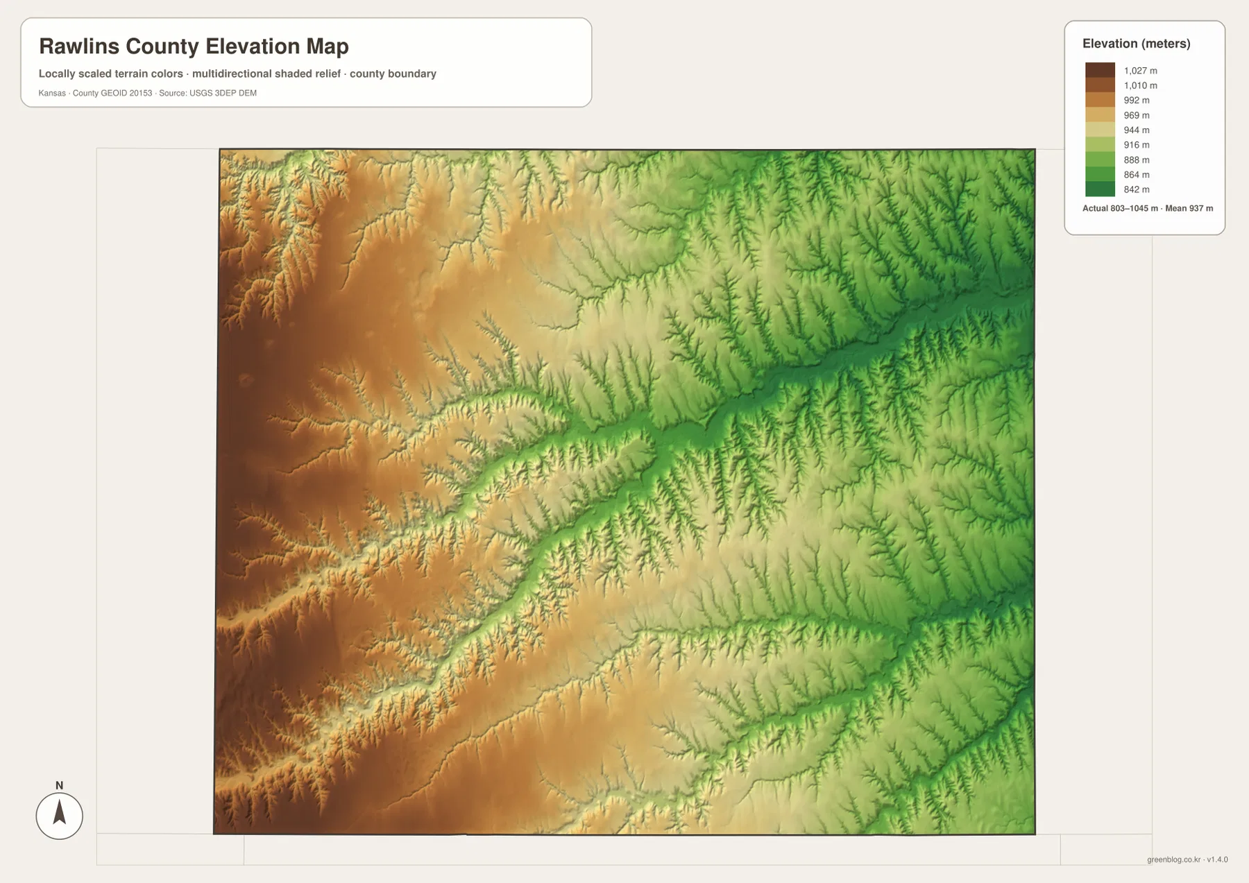
The Atwood-to-eastern-county side contains broader connected lowlands than the McDonald and northwestern side. Small tributaries are especially visible where they cut down through the western high ground, while the eastern valleys occupy larger continuous areas. This west-to-east drop is one of the clearest features on the supplied relief image.
The elevation surface is generalized for county-scale comparison. It is not survey-grade or engineering-grade measurement and should not be used for parcel elevations, construction grades, drainage design, or legal boundary work.
Atwood combines county government, transportation, and local history
The Kansas Historical Society records Rawlins County as organized in 1881 and identifies Atwood as the county seat. That historical role still makes sense geographically: Atwood sits at the US 36 and K-25 crossroads close to the Beaver Creek valley, with road and rail connections converging around the town.
The Shirley Opera House provides a county-specific historic landmark within Atwood. Kansas Historical Society records list the 1907 building on the National Register of Historic Places and describe its role in local performances and community gatherings. Although the county map does not show building-level detail, the site adds useful context to Atwood’s long-standing role as Rawlins County’s civic center.
US 36 from McDonald to Atwood crosses from high western ground into the Beaver valley
The McDonald-to-Atwood section of US 36 looks like a simple east–west connection on the road map. The elevation image adds another layer: higher terrain dominates around the western county, and the route approaches a broader lowland as it nears Atwood and the Beaver Creek system.
The water image shows why that transition occurs. North Fork and Middle Fork Beaver Creek descend toward the central valley, while South Fork Beaver Creek approaches from the southwest. Their combined drainage creates a wider low area around the Atwood side than the narrower tributary cuts farther west.
Herndon shows the lower, more heavily dissected northeastern side
Herndon lies close to the northeastern county edge and is about 15 direct miles from Atwood on the city-connections panel. This part of the county contains many small tributaries feeding the eastern Beaver Creek and Driftwood Creek systems, so the terrain is divided into numerous narrow ridges and valleys.
The relief map shows more green and lower-elevation terrain toward this side than in the west. Comparing Atwood with Herndon therefore reveals another part of the county’s overall descent from the high western High Plains toward the lower eastern drainage network.
For posters, classroom prints, or presentation slides, use the original JPG files in the download archive rather than enlarging the web previews. Small road labels, creek names, community labels, and the elevation legend remain clearer at the higher resolution.
Frequently Asked Questions
Is Herndon or McDonald closer to Atwood on the supplied city map?
Herndon is shown about 15 direct miles from Atwood, while McDonald is about 18 direct miles away. These are straight-line distances rather than driving distances.
Do Beaver Creek and Sappa Creek occupy the same valley?
No. Beaver Creek and its forks form the main central drainage, while the North, Middle, and South Fork Sappa Creek valleys occupy the southern half of the county. Higher uplands separate the two systems.
Can the 803–1,045 meter elevation image be used for surveying?
No. It is a generalized county-scale terrain image for comparing the high western High Plains with lower creek valleys. Parcel elevations, engineering grades, drainage design, and legal boundary work require more precise official data and, where needed, professional surveying.
Map File Information
The archive contains the Rawlins County, Kansas general county map, city-connections map, terrain-and-water map, and elevation map as original high-resolution JPG files.
- Included Files: Use only the versions confirmed in the article and supplied images
- File Type: Use the confirmed download contents
- Intended Use: Printing, education, presentations, and map-based projects
Related Maps
Sources and references
- Rawlins County Kansas — local community, transportation, and county information
- Kansas Historical Society: Rawlins County, Kansas — county seat, High Plains setting, history, and local historic properties
- Kansas Department of Transportation: U.S. 36 Rawlins County project — US 36 and the Atwood K-25 junction
- U.S. Census Bureau TIGER/Line Shapefiles — county boundary and geographic reference data
- USGS National Hydrography — river and stream reference data
- USGS 3D Elevation Program — elevation and terrain reference data
Green Map creates custom-edited map images using open geographic data sources such as geoBoundaries, Natural Earth, OpenStreetMap, and government open data.
These maps are edited visual materials, not raw data files, and are provided for education, documents, presentations, and graphic reference.