Reno County sits in south-central Kansas, with Hutchinson forming a much larger urban center than the surrounding communities. South Hutchinson, Buhler, Haven, Nickerson, and Pretty Prairie occupy smaller settings across a broad rural county. US 50, K-61, K-14, and K-17 provide useful road references, while the Arkansas River, Cow Creek, and the Ninnescah drainage explain many of the county’s low areas. High-resolution map files are available for download in the section below.
This guide follows Hutchinson and the surrounding communities across the road, water, and relief views, with elevations ranging from about 430 to 556 meters. WebP previews are available for quick viewing, and the matching high-resolution JPG files can be downloaded together in one ZIP for printing, classroom work, or offline reference.
Table of Contents
Hutchinson and South Hutchinson form the county’s main road and rail center
The strongest concentration of roads and rail lines appears around Hutchinson and South Hutchinson. US 50 runs across the southern side of the urban area and continues toward Haven, while K-61 connects the Hutchinson area with the north. K-14 provides a north–south reference through the western part of the county around Arlington, and K-17 serves the rural south.
Reno County government offices are based in Hutchinson, and the Kansas Historical Society identifies Hutchinson as both the county seat and the county’s largest city. The general map makes that role easy to understand because the urban footprint, rail network, and major highways are far denser here than around the smaller towns.
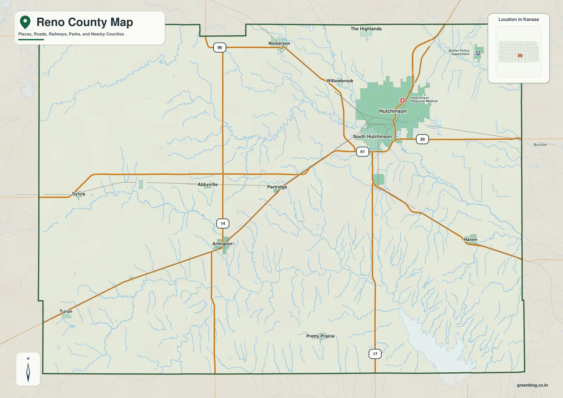
Nickerson lies northwest of the Hutchinson urban area, while Buhler occupies the northeastern side. Haven sits along the eastern US 50 corridor, and Arlington and Sylvia provide western rural references. The settlement pattern is therefore not one continuous city strip; smaller communities are spread along different road and rail corridors around Hutchinson.
Hutchinson dominates the six-city index
The city panel ranks Hutchinson at 39,709. South Hutchinson follows at 2,751, Buhler at 1,525, Haven at 1,313, Nickerson at 1,001, and Pretty Prairie at 641. These are map index values rather than current official population estimates, but they explain the large visual difference between Hutchinson and the other city markers.
The smaller communities occupy very different settings. South Hutchinson is directly tied to the main urban area, while Buhler and Nickerson sit in the northern half of the county. Haven belongs to the eastern US 50 corridor, and Pretty Prairie is much farther south in a more rural landscape.
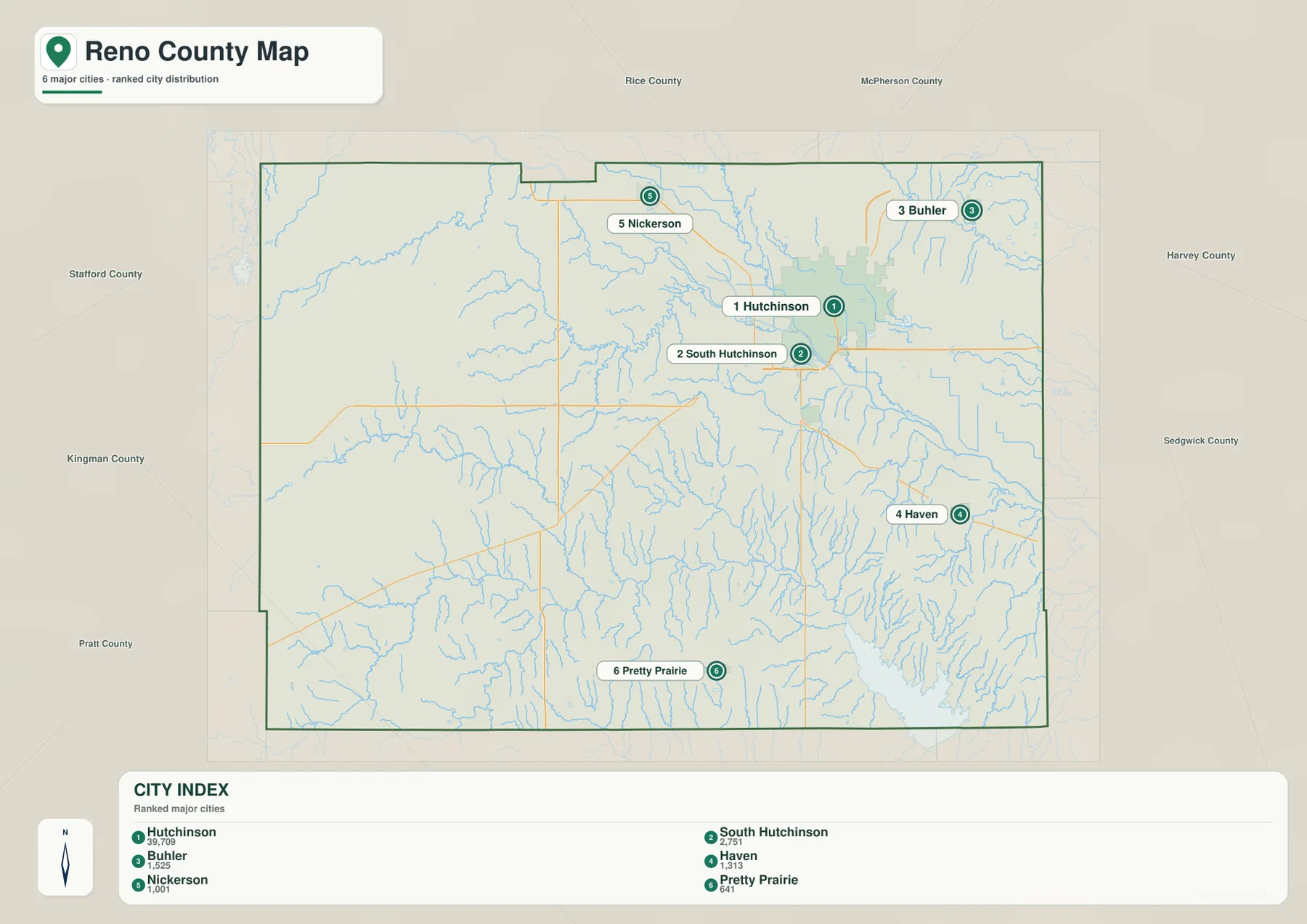
Kansas Historical Society population material also identifies Hutchinson as the county’s largest city. The official census figures and the supplied map index are different datasets and should not be treated as interchangeable, but both reflect the county’s strong concentration around Hutchinson.
The Arkansas River and Cow Creek organize the Hutchinson lowlands
The Arkansas River is one of the most important water features in Reno County. It enters the county from the northwest and continues toward the Hutchinson area, creating broad low terrain along its route. Kansas Historical Society material also identifies the Arkansas River and Cow Creek as major geographic features of the county.
Cow Creek descends through the northern half toward the Hutchinson area, while Salt Creek creates a separate long valley farther west. In the northeast, the Little Arkansas River provides another major channel, with Panorama Lake, Brandy Lake, Magwire Lake, and smaller water bodies nearby.
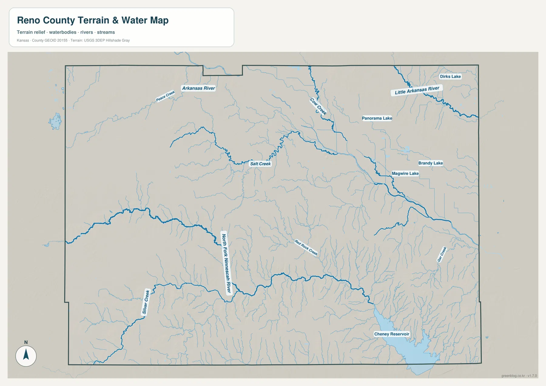
The southern half is organized around the North Fork Ninnescah River. Silver Creek and Red Rock Creek join the drainage from surrounding uplands, while Cheney Reservoir occupies a large low area in the southeast. Grant Creek and many short tributaries further divide the terrain around the reservoir.
This water image is intended for geographic reference rather than floodplain, navigation, water-quality, parcel, or legal-access decisions. River flow, lake level, and recreation conditions can change, so current agency information should be used whenever access or safety matters.
Elevation from 430 to 556 meters drops from the west toward the river valleys
The elevation surface ranges from about 430 to 556 meters, with a mean near 488 meters. Brown and tan terrain dominates much of the west and southwest, while green lowlands become more extensive around Hutchinson, the eastern half, and the southeastern reservoir country. More than 100 meters of local relief separates the highest and lowest parts of the county.
The Arkansas River and Cow Creek occupy broad lower terrain around the central and eastern side. The North Fork Ninnescah River and Cheney Reservoir create another large low zone in the south and southeast. In contrast, the Arlington and Sylvia side retains more extensive higher ground cut by narrower creeks.
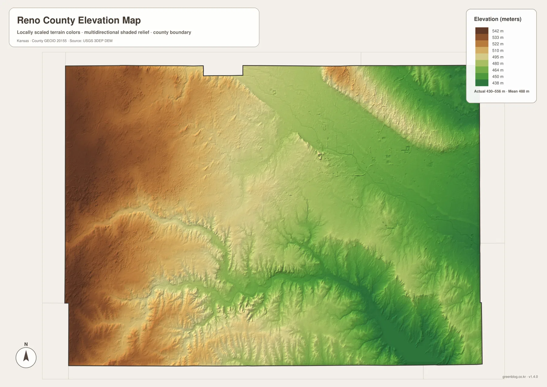
The northeast is lower overall but still contains ridges between the Little Arkansas River and its tributaries. Pretty Prairie lies in an intermediate southern setting where rolling uplands are crossed by numerous small streams feeding the Ninnescah system.
The elevation surface is generalized for county-scale comparison. It is not survey-grade or engineering-grade measurement and should not be used for parcel elevations, construction grades, drainage design, or legal boundary work.
Sand Hills State Park preserves dune country just north of Hutchinson
Kansas Department of Wildlife and Parks places Sand Hills State Park north of Hutchinson, about one mile east of K-61. The 1,123-acre natural area preserves sand dunes, grasslands, wetlands, and woodlands, providing a distinctive landscape very close to the county’s main urban center.
The park’s trail system passes through dunes that the agency describes as roughly 10 to 40 feet high. That detail gives useful real-world context to the subtle rolling terrain north of Hutchinson that can be easy to overlook on a county-scale elevation image.
Cheney Reservoir anchors the southeastern water landscape
Cheney Reservoir is the largest single water body visible in the southeastern part of the supplied map. Kansas Department of Wildlife and Parks lists Cheney State Park and Cheney Wildlife Area among its Reno County locations, tying the reservoir directly to the county’s outdoor recreation landscape.
The water and relief images show the reservoir within a broad low area connected to the Ninnescah drainage and many short tributaries. The supplied map does not represent current reservoir level, access restrictions, or facility status, so those details should be checked with the park or managing agency before a visit.
Moving west from Hutchinson reveals a different rural terrain
Leaving Hutchinson toward Arlington or Sylvia means moving away from the dense road and rail network into higher rural ground. The western side contains fewer major channels and more narrow creek valleys, creating a different physical setting from the broad lowlands around the county’s main city.
Travel toward Haven shows another pattern, with US 50 crossing lower eastern terrain and numerous small streams. South toward Pretty Prairie, the road network enters rolling country associated with the North Fork Ninnescah drainage. Comparing these corridors makes Reno County’s internal differences much clearer than treating each map as a separate checklist.
For posters, classroom prints, or presentation slides, use the original JPG files in the download archive rather than enlarging the web previews. Small road labels, creek names, town text, and the elevation legend remain clearer at the higher resolution.
Frequently Asked Questions
Which city is largest on the supplied city index?
Hutchinson ranks first at 39,709. South Hutchinson is 2,751, Buhler 1,525, Haven 1,313, Nickerson 1,001, and Pretty Prairie 641. These are map index values rather than current official population estimates.
Do the Arkansas River and North Fork Ninnescah River share the same valley?
No. The Arkansas River and Cow Creek shape broad lowlands around the Hutchinson side, while the North Fork Ninnescah River crosses the southern half as a separate drainage corridor. Cheney Reservoir occupies another large low area in the southeast.
Can the 430–556 meter elevation image be used for surveying?
No. It is a generalized county-scale terrain image for comparing higher western ground with lower river and reservoir valleys. Parcel elevations, engineering grades, drainage design, and legal boundary work require more precise official data and, where needed, professional surveying.
Map File Information
The archive contains the Reno County, Kansas general county map, city map, terrain-and-water map, and elevation map as original high-resolution JPG files.
- Included Files: Use only the versions confirmed in the article and supplied images
- File Type: Use the confirmed download contents
- Intended Use: Printing, education, presentations, and map-based projects
Related Maps
Sources and references
- Reno County, Kansas official website — county government and Hutchinson-based services
- Kansas Historical Society: Reno County, Kansas — county seat, Arkansas River, Cow Creek, history, and regional geography
- Kansas Department of Wildlife and Parks: Sand Hills State Park — dunes, grasslands, wetlands, trails, and location north of Hutchinson
- Kansas Department of Wildlife and Parks: Cheney State Park — Cheney Reservoir recreation and facilities
- U.S. Census Bureau TIGER/Line Shapefiles — county boundary and geographic reference data
- USGS 3D Elevation Program — elevation and terrain reference data
Green Map creates custom-edited map images using open geographic data sources such as geoBoundaries, Natural Earth, OpenStreetMap, and government open data.
These maps are edited visual materials, not raw data files, and are provided for education, documents, presentations, and graphic reference.