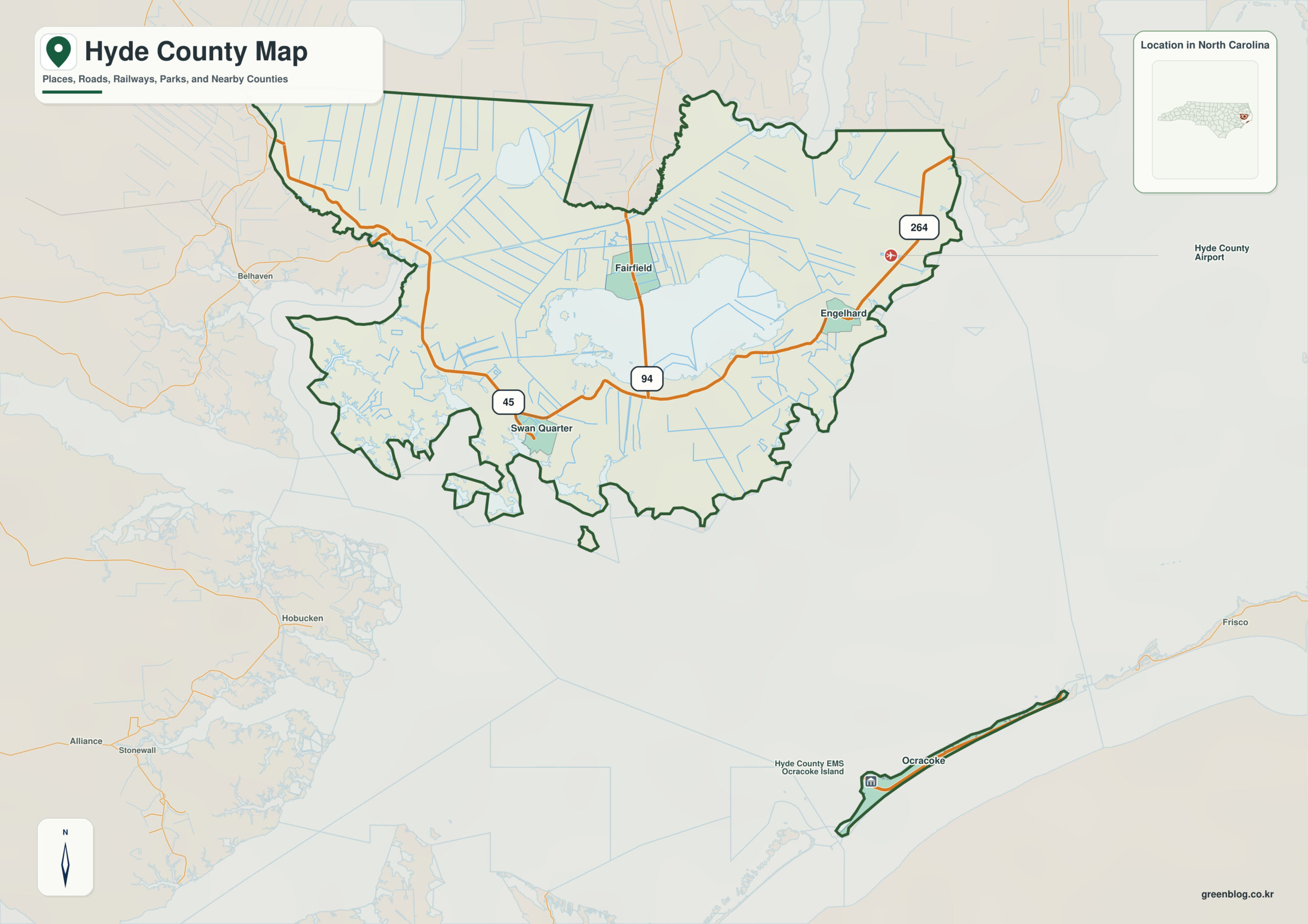
Hyde County North Carolina map needs a mainland-versus-island reading from the start. Swan Quarter and Engelhard belong to the mainland around Lake Mattamuskeet, while Ocracoke sits across Pamlico Sound on the Outer Banks, so the county cannot be reduced to a normal county-seat sequence.
Swan Quarter is a starting point, not a complete description of the county. Ocracoke, Engelhard, Lake Mattamuskeet, and Pamlico Sound reveal additional settlement and landscape zones that would otherwise disappear.
Hyde County quick facts
- County seat: Swan Quarter
- North Carolina setting: Inner Banks and Outer Banks
- Place references: Swan Quarter, Ocracoke, Engelhard
- Physical references: Lake Mattamuskeet, Pamlico Sound, Ocracoke Island
- Neighboring counties: Beaufort, Dare, Tyrrell, Washington
Mainland Hyde and Ocracoke are separate worlds
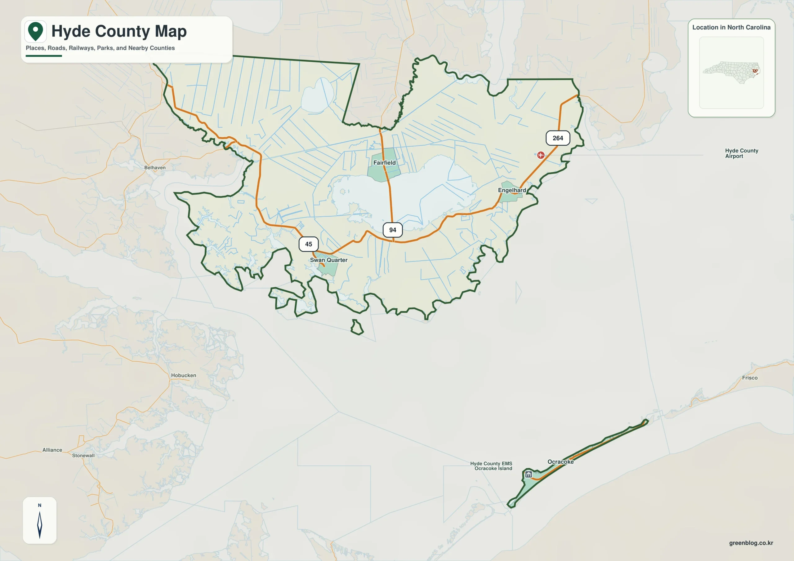
Swan Quarter and Engelhard belong to mainland Hyde, but Ocracoke lies across Pamlico Sound on the Outer Banks. The first map decision should therefore be mainland versus island, followed by Lake Mattamuskeet as the main mainland anchor.
Lake Mattamuskeet as the mainland anchor
Lake Mattamuskeet dominates mainland Hyde and separates western Beaufort/Washington directions from the Pamlico Sound side. Ocracoke then forms a second geographic world across the sound rather than an extension of the mainland road grid.
Pamlico Sound divides the county internally
Hyde is sparsely populated and physically divided by large water bodies, making a lake-sound-island reading more accurate than a county-seat-centered layout.
This county is clearer when settlement references (Swan Quarter, Ocracoke, Engelhard) and physical references (Lake Mattamuskeet, Pamlico Sound) remain separate. The distinction improves both geographic interpretation and later use of demographic, transport, or recreation layers.
Avoiding false distance assumptions
- compare Swan Quarter and Ocracoke through the Lake Mattamuskeet reference
- orient the Beaufort side of the county before reading smaller labels
- use the county image as a base reference before switching to street, parcel, hazard, or navigation mapping
Hyde County single map file
The image above is a web preview. The button is reserved for the separate original map asset used in the publishing workflow.
Download the Hyde County map fileFrequently Asked Questions
Why is Lake Mattamuskeet one of the map's most useful non-city references?
The value of Lake Mattamuskeet is that it explains physical orientation while the named communities explain settlement. Using both layers together produces a more accurate county-scale reading.
How does Ocracoke prevent an overly simplified Swan Quarter-centered map?
Swan Quarter and Ocracoke do not need to have the same administrative status to be equally useful for orientation. One marks the seat; the other helps represent a different part of the county.
Sources
Related County Maps
Green Map creates custom-edited map images using open geographic data sources such as geoBoundaries, Natural Earth, OpenStreetMap, and government open data.
These maps are edited visual materials, not raw data files, and are provided for education, documents, presentations, and graphic reference.