A Korean version of this map page is available. View Korean Page
Seoul is one of the most frequently referenced cities in Korea for presentations, educational materials, travel planning, and infographic projects. Because the city is divided into many districts along the Han River, a clean and readable Seoul map can be much more useful than a simple screenshot or navigation capture.
This map collection was designed with practical use in mind. Instead of focusing on excessive detail, the layouts were simplified to make district boundaries easier to read on screen and in print.
The files were created in high resolution for A3-size printing, making them suitable for classroom handouts, blog graphics, presentation slides, and editing projects.
Table of Contents
Map Overview
Seoul is located in the northwestern part of South Korea and serves as the center of the Seoul metropolitan area. The city is divided into multiple administrative districts, commonly known as “gu,” which are often used in regional comparison materials and location-based explanations.
The Han River runs across the city and acts as one of the main geographic references when explaining district layouts.
This collection focuses on readability and practical use rather than detailed transportation or street-level information.
Included Map Types
The Seoul map package includes three different styles:
- Regional color map
- Black and white printable map
- Blank outline map
File Information:
- Resolution: 4961 × 3508
- Format: JPG
- Color Mode: CMYK
- Designed for: Printing, editing, presentations, and educational use
Regional Color Seoul Map
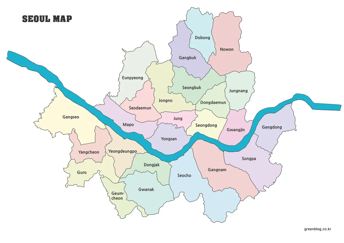
The color version was created to make Seoul’s district structure easier to understand at a glance. Each district is separated using different colors, helping users quickly identify regional layouts without needing additional labels or overlays.
This version works especially well for:
- presentation slides
- educational reference materials
- blog graphics
- regional comparison visuals
- infographic layouts
The larger canvas size also makes the map easier to read when projected on screens or printed in poster format.
Black and White Printable Version
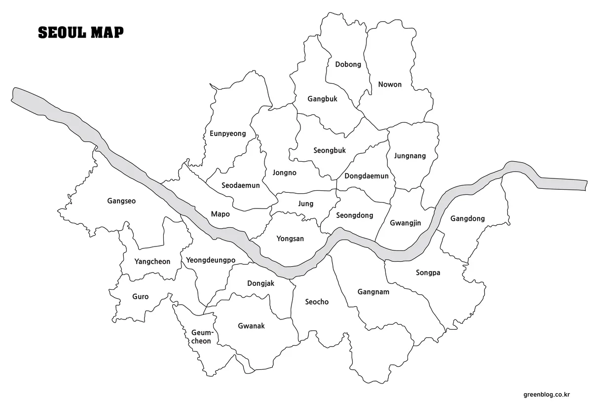
The black and white version removes most background colors and focuses on boundaries and labels instead. This layout is often easier to print clearly, especially when using standard office printers or classroom printouts.
Because the map uses minimal visual elements, it also works well for:
- note-taking
- annotations
- worksheets
- printed reports
- grayscale documents
This version keeps district separation visible without relying on color differences.
Blank Outline Map for Editing

The outline version removes colors and labels completely, leaving only district borders and the outer city shape.
This layout is useful when creating:
- custom infographic projects
- multilingual labels
- travel route graphics
- statistics overlays
- educational exercises
- presentation visuals
The simplified structure allows users to add their own text, colors, or symbols without visual clutter.
Designed for Printing and Presentation Use
These Seoul maps were created in high resolution to remain readable even when enlarged or printed in A3 format.
The files work well for:
- classroom presentations
- regional comparison materials
- travel planning graphics
- blog illustrations
- editable design projects
- district reference guides
Because the layouts avoid unnecessary visual noise, they also fit naturally into documents and slides without overpowering surrounding content.
Frequently Asked Questions
Can I print the maps in large size?
Yes. The files were designed for high-resolution A3 printing.
Is the outline map editable?
Yes. The blank version works well for editing, annotations, and graphic design projects.
Are district names included?
The color and black and white versions include district labels. The outline version removes them for easier editing.
Download Information
Seoul Map Download
The Seoul map files can be downloaded using the link below. Choose from the color map, black and white map, or outline map depending on your project or printing needs.
- File Format: JPG / PNG / ZIP
- Usage: Printing · Presentation · Editing
- Size: High Resolution A3 Format
The files are provided in ZIP format. Extract the archive after downloading to access all included map versions.
Related Map Collections
If you are looking for more printable regional maps, these collections may also be useful for comparison, presentation slides, or educational reference materials. Additional Seoul travel and district information can also be explored through Visit Seoul Official Guide.
Green Map creates custom-edited map images using open geographic data sources such as geoBoundaries, Natural Earth, OpenStreetMap, and government open data.
These maps are edited visual materials, not raw data files, and are provided for education, documents, presentations, and graphic reference.