A Mactan Island Map is most useful when it separates three ideas that visitors often combine: the island itself, nearby mainland Cebu, and the surrounding channels and smaller islands. The supplied travel illustration enlarges Mactan’s coastline, shows a northern bridge connection, and places Olango Island to the southeast. It also identifies selected visitor businesses and coastal points rather than attempting to reproduce a complete street map.
The set contains a color travel map, a black-and-white labeled version, and an unlabelled outline. All three previews measure 1200 × 740 pixels and share the same landscape frame; the preserved source information identifies the original downloadable map as 4463 × 2753 pixels. This consistent geometry lets readers move from a finished reference to a printer-friendly planning sheet or a clean base for custom labels.
Mactan forms part of Cebu Province in the central Philippines. The official Lapu-Lapu City website explains that Lapu-Lapu City and the Municipality of Cordova comprise the island, and that bridges connect it with the main Cebu landmass. Mactan-Cebu International Airport is an important part of the island’s travel context, but it is not labeled on these supplied images. The maps should therefore support general orientation and visual projects, not replace live navigation.
Table of Contents
What This Mactan Island Map Includes
The labeled artwork combines an island outline with selected roads, point markers, text boxes, and surrounding-water labels. Visible geographic references include Magellan Bay, Hilutungan Channel, Olango Island, and the Marcelo Fernan Bridge at the northwestern edge. These features help establish direction even though the map has no compass arrow, scale bar, distance table, or coordinate grid.
Visitor labels include Mactan Newtown Beach, Happy Beach Cebu, the Lapu-Lapu Statue and Magellan Shrine area, Island Central Mactan, several malls, dive operators, tour businesses, and other commercial locations. Their presence makes the image a selective visitor map rather than an administrative or comprehensive attractions inventory. Businesses, operating names, and access arrangements can change, so readers should verify any planned stop before traveling.
Several important elements are absent. The Mactan Island Map does not label the airport, Cebu City, Cordova, the internal boundary between Lapu-Lapu City and Cordova, every bridge, every street, hotel locations, public transport routes, or travel times. It also does not distinguish which markers are landmarks, shops, tour operators, or educational institutions through a formal legend. Those limits should shape how the file is used.
English labels make the named points easier to compare with international travel pages and booking searches, but spelling on a static image should not be treated as the final authority. Use the map to understand relative placement, then confirm current names and directions through official destination pages or a live navigation service.
Color Travel Map for Tourist Spots and Island Layout
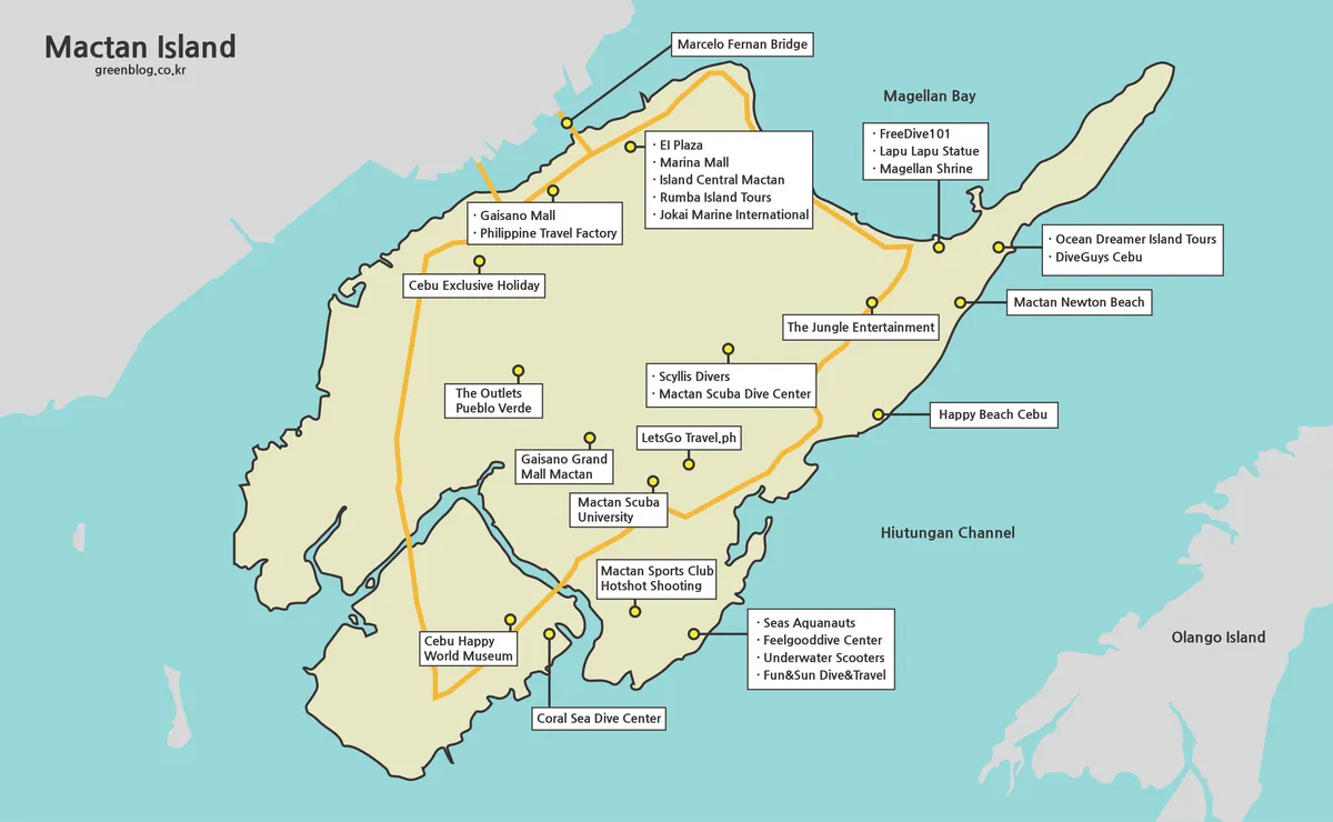
The color Mactan Island Map uses pale yellow-green for Mactan, turquoise for water, and gray for surrounding land. An orange road line crosses the island and connects selected parts of the visitor layout, while yellow point symbols link to labels through short leaders. The restrained palette keeps the irregular coastline visible without competing with the many white text boxes.
Water color is especially useful here because the image must explain more than the main island. The gap toward mainland Cebu, the eastern water beside Olango Island, Magellan Bay, and Hilutungan Channel become immediately distinct from land. This makes the color version the clearest choice for an introductory slide, travel article graphic, or on-screen explanation of Mactan’s setting.
The map’s markers are reference points, not a turn-by-turn route. Orange lines do not provide road numbers, direction restrictions, traffic conditions, or measured travel times. A viewer can see that labeled places occupy different parts of the island, but should not infer that every point lies directly on the highlighted line or that the illustrated route is the fastest connection.
For presentation use, introduce the island shape first and then highlight only the labels relevant to the itinerary. The northeastern coast contains several closely spaced callouts, so adding more text there can obscure the map. Open water provides safer space for a short legend or title, provided that Magellan Bay and Hilutungan Channel remain readable.
Black and White Printable Version
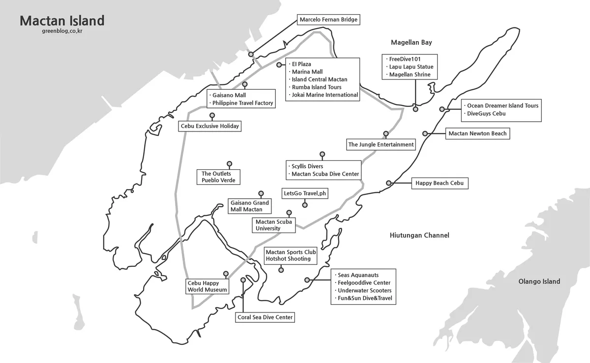
The monochrome Mactan Island Map retains the roads, point markers, visitor labels, bridge, channel names, and Olango Island context while removing the blue water and colored island fill. Gray surrounding land and road lines still separate major visual layers. This neutral treatment fits printed travel folders, report pages, group-planning handouts, or documents with an established color scheme.
Because the existing labels remain, this version works best for annotation rather than an identification quiz. Travelers can circle potential stops, number a tentative sequence, or write confirmation notes beside selected businesses. They should avoid drawing a route as if it were verified navigation, particularly because the map does not show the full street network, bridge options, or current traffic constraints.
Use landscape orientation and preserve the aspect ratio when printing. The original 4463 × 2753 file provides more source detail than the 1200 × 740 page preview, but physical legibility still depends on the chosen print size and printer. Test one sheet before a large batch, checking the smaller commercial labels and leader lines around the eastern and central parts of the island.
Black and white does not mean low-detail or blank. It still contains most of the travel information visible in the color edition. Anyone who needs an uncluttered shape for entirely new content should use the outline file instead of erasing dozens of labels from this version.
Blank Outline Map for Editing and Route Marking
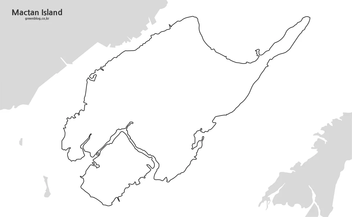
The outline Mactan Island Map removes roads, pins, visitor labels, bridge text, and water names. It preserves the main island’s detailed coastline and the gray silhouettes of nearby land, including the Olango Island area at the southeastern edge. The “Mactan Island” page title remains, so the file is a geographic blank base rather than a completely text-free canvas.
This version provides room for a single-purpose graphic. A traveler might add confirmed accommodation and transfer points; a teacher could ask students to indicate nearby Cebu and Olango; a blogger could mark only the locations mentioned in one article. Keeping the task narrow prevents the custom layer from recreating the crowded conditions that the clean outline is meant to solve.
When adding routes, treat them as explanatory diagrams unless they have been checked against current road and marine information. Boat routes, pickup sites, resort access, and bridge traffic can be operationally sensitive. Use distinct symbols for verified places and approximate areas, provide a legend, and attach a date and source to any factual overlay.
The downloadable resource is an image-based map, not a claimed vector or GIS dataset. It can support worksheets, blog illustrations, presentation graphics, and personal planning sheets, but it is not suitable for distance measurement, legal boundaries, marine navigation, or emergency routing.
Practical Ways to Use the Mactan Island Map
Start by choosing the version that matches the decision. Use color to explain the island and surrounding water quickly, black and white when existing labels must remain on a printed sheet, and outline when the reader will add new information. This approach is more reliable than treating the three images as interchangeable visual styles.
For an arrival overview, pair the map with a note that the airport is on Mactan but is not marked in the artwork. For sightseeing, identify only the places actually relevant to the day and verify them before departure. For island-hopping material, preserve the Hilutungan Channel and Olango context while using current operator instructions for departure points and schedules.
A blog post can use the labeled Mactan Island Map to introduce relative locations, then link to current information for transport and admissions. A classroom activity can compare the labeled version with the outline and ask which geographic clues disappear. In both cases, the strongest lesson is not a precise itinerary but the island’s relationship to mainland Cebu, surrounding water, and nearby islands.
Frequently Asked Questions
What is included in this Mactan Island Map collection?
The collection includes a color travel map, a black and white printable map, and a blank outline map. Each version is designed for a different purpose, from travel planning to graphic editing.
Is this Mactan Island Map suitable for printing?
Yes. The original map size is 4463×2753, which gives users more detail than a small preview image. For printing, the black and white version is usually the easiest to use.
Why are the labels written in English?
English labels make it easier to match places with hotel booking sites, navigation apps, travel guides, and local search results used by international travelers.
Can I use the outline map for travel route marking?
Yes. The blank outline version works well for marking airport transfers, resort locations, island hopping routes, and custom travel notes.
Download Information
Map File Information
The archive contains three Mactan Island image maps for orientation, printing, annotation, and visual projects.
- Included Versions: Color travel map, black and white map, outline map
- File Type: Image files in a ZIP archive
- Intended Use: Travel reference, handouts, blog graphics, presentations, and custom labeling
Related Maps
Additional Resources
- Lapu-Lapu City Government: About the City — Read official background on Mactan Island’s local-government setting, bridge connections, airport, and relationship with Cebu.
Green Map creates custom-edited map images using open geographic data sources such as geoBoundaries, Natural Earth, OpenStreetMap, and government open data.
These maps are edited visual materials, not raw data files, and are provided for education, documents, presentations, and graphic reference.